
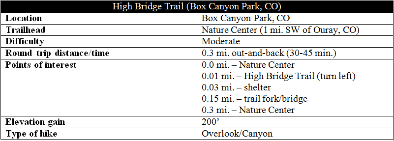
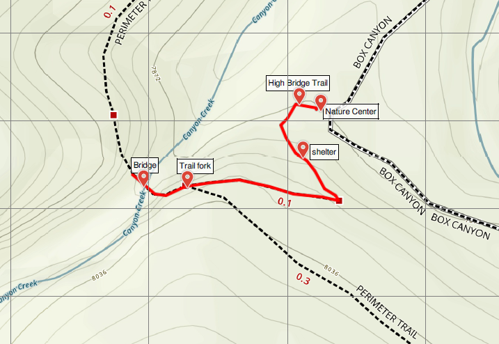
The High Bridge Trail is a more strenuous alternative to the lower Box Canyon Falls Trail, climbing 200 feet to a suspension bridge that spans Box Canyon and offers views northeast to Ouray, Colorado. On sunny summer days and weekends, it’s also likely to be jam-packed with visitors, making an early morning or late afternoon jaunt the best option.
The hike
Begin at the Nature Center in Box Canyon Park, situated halfway down the signed, one-way drive that connects Route 550 (a.k.a., “Million Dollar Highway”) with 3rd Avenue in Ouray. A $4/person entrance fee applies.

After exploring the Nature Center, head west on the wide trail and take your first left at the foot of a metal staircase, which marks the start of the High Bridge Trail. (Note: The main trail to the base of Box Canyon Falls continues straight.) Climb the stairs for initial views of Ouray, then continue left as the path hugs the hillside en route to a covered shelter after around 50 yards. Billed in the trail guide (obtained at the Nature Center) as a “panorama,” there are some decent views from here of Ouray and the San Juan Mountains. On a clear day, it is easy to spot Cascade Falls across the valley, as well as geological features known as the Blowout and the Amphitheater.

Continuing onward, the narrowing footpath rounds a switchback at about the 100-yard mark, and then climbs sharply westward toward the Box Canyon. The tree life is classic Colorado: Rocky Mountain junipers, Douglas firs, ponderosa pines, and other conifers – plus some deciduous, like Gambel oaks, mixed in.
The steep and rocky climb ends abruptly at around 0.15 miles, where the High Bridge Trail merges with the Ouray Perimeter Trail. With the bridge in sight, take a right, continuing the last few steps to your destination.

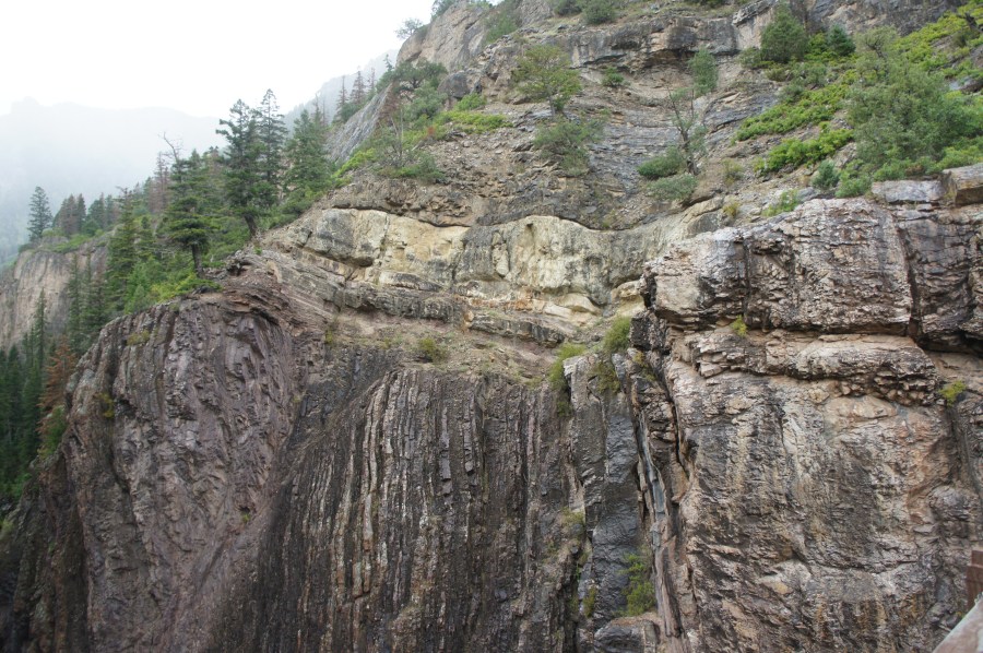
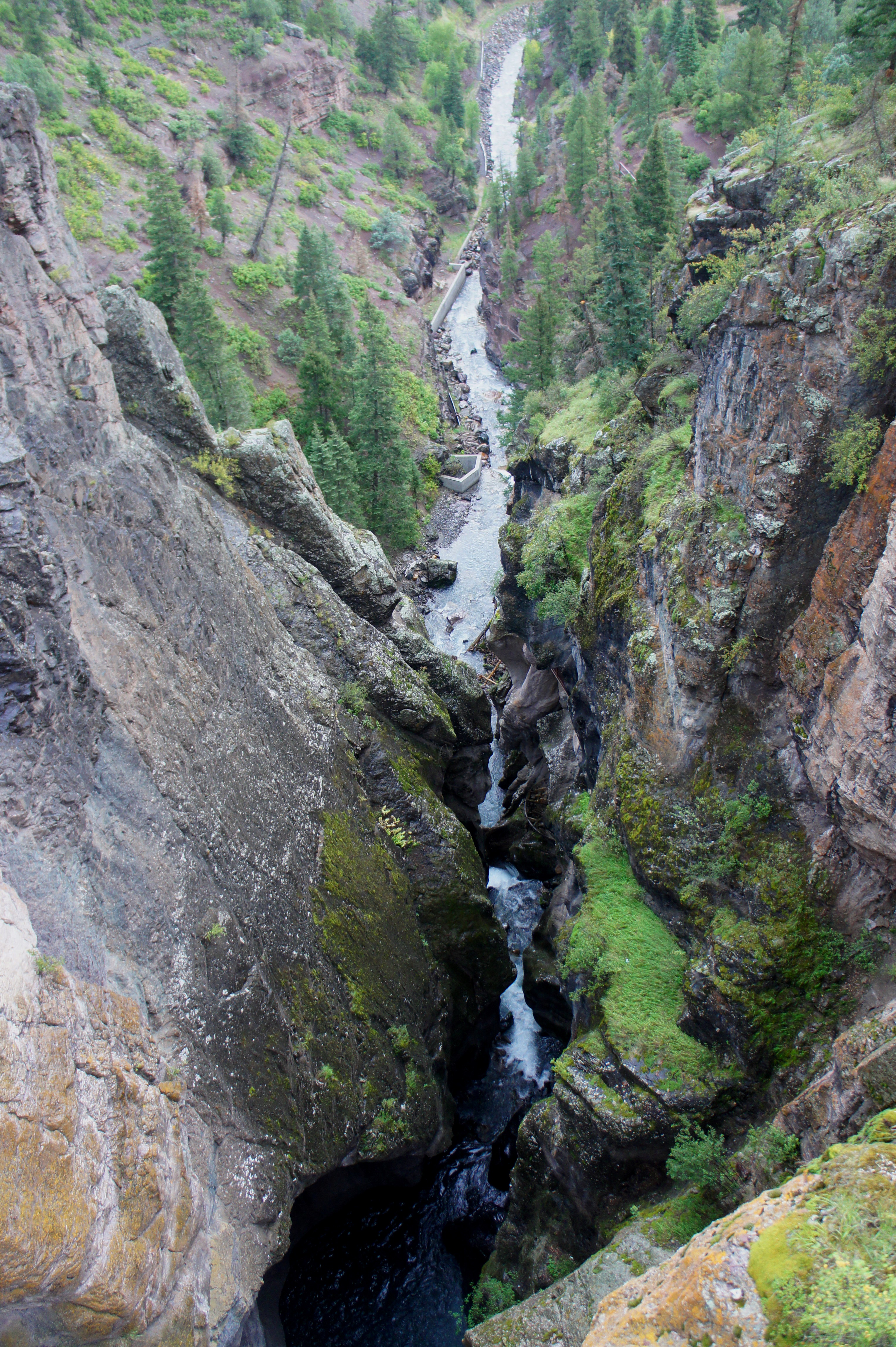
The bridge spans a deep and narrow gorge composed mostly of ancient, white quartzite and black slate (550+ million years old). A wayside at the bridge extends the stratigraphic column to include “newer” layers of limestone, sandstone, and shale (300-400 million years old), which are visible along the canyon’s right flank. Directly below your feet, of course, Canyon Creek tumbles through the deep-cut gorge, forming Box Canyon Falls. While barely visible, the presence of the falls is unmistakable by the thundering noise of the crashing waters.

Just beyond the bridge lies a remnant of human history: a dark and damp tunnel that was built for a water pipeline project in the early 1900s before it was abandoned in the 1950s. After exploring the bridge and tunnel, return the way you came—or continue down the Ouray Perimeter Trail to return to town. For the out-and-back to the bridge, allot between 30 and 45 minutes, depending on fitness levels for the steep climb.
Extra credit
Hike the lower trail in Box Canyon, then explore some other, more challenging trails in the Ouray area, such as the Ouray Perimeter Trail, Portland Trail, or Sutton Mine Trail.

Pingback: Box Canyon Falls Trail (Box Canyon Park, CO) | Live and Let Hike