Set in the southern reaches of the Desolation Wilderness, Horsetail Falls is a local landmark visible to those driving along U.S. Route 50 between Placerville, California and Lake Tahoe. More of a series of tumbles than a sheer drop, the waterfall on Pyramid Creek drains many of the premier lakes of Desolation Valley above (including the famous Lake Aloha) and is sometimes used as an access point for backpackers heading up into the wilderness. But for most visitors, Horsetail Falls is a moderately strenuous half-day hike, culminating at lovely swimming holes set against roaring cascades, enlivening a landscape recently charred by the 2021 Caldor Fire.

The hike
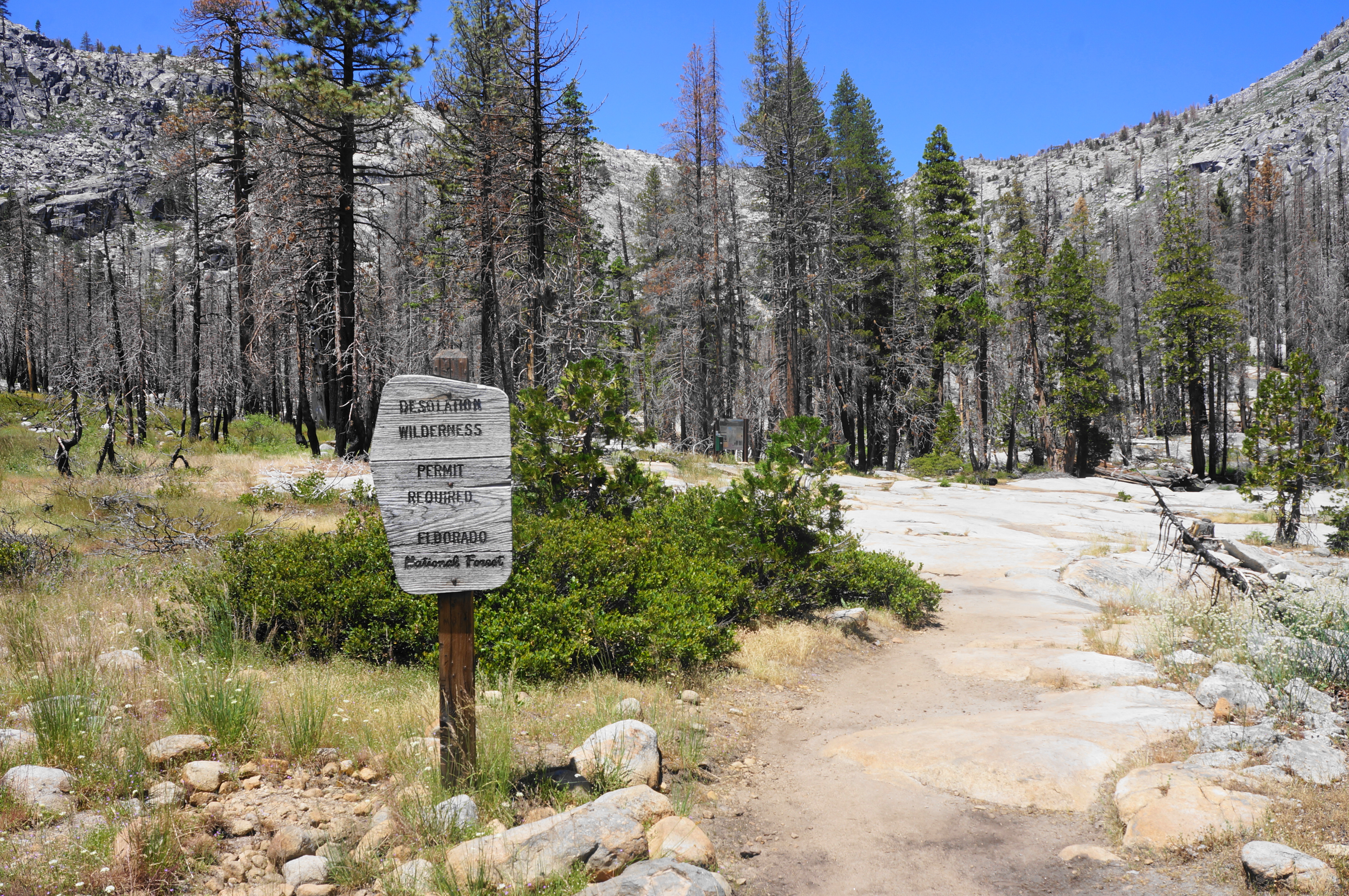
The Pyramid Creek Trailhead, the staging point for the hike to the base of Horsetail Falls, is situated just off U.S. Route 50 in the very modest town of Twin Bridges, California, within the boundary of Eldorado National Forest. Here Pyramid Creek races to meet the South Fork of the American River, which forms a large canyon eventually more than 2,000 feet deep. Much to the consternation of some, there is a small fee to park at the trailhead, with room for upwards of 50 cars. There is also a restroom, and cell service can be found here for some carriers.
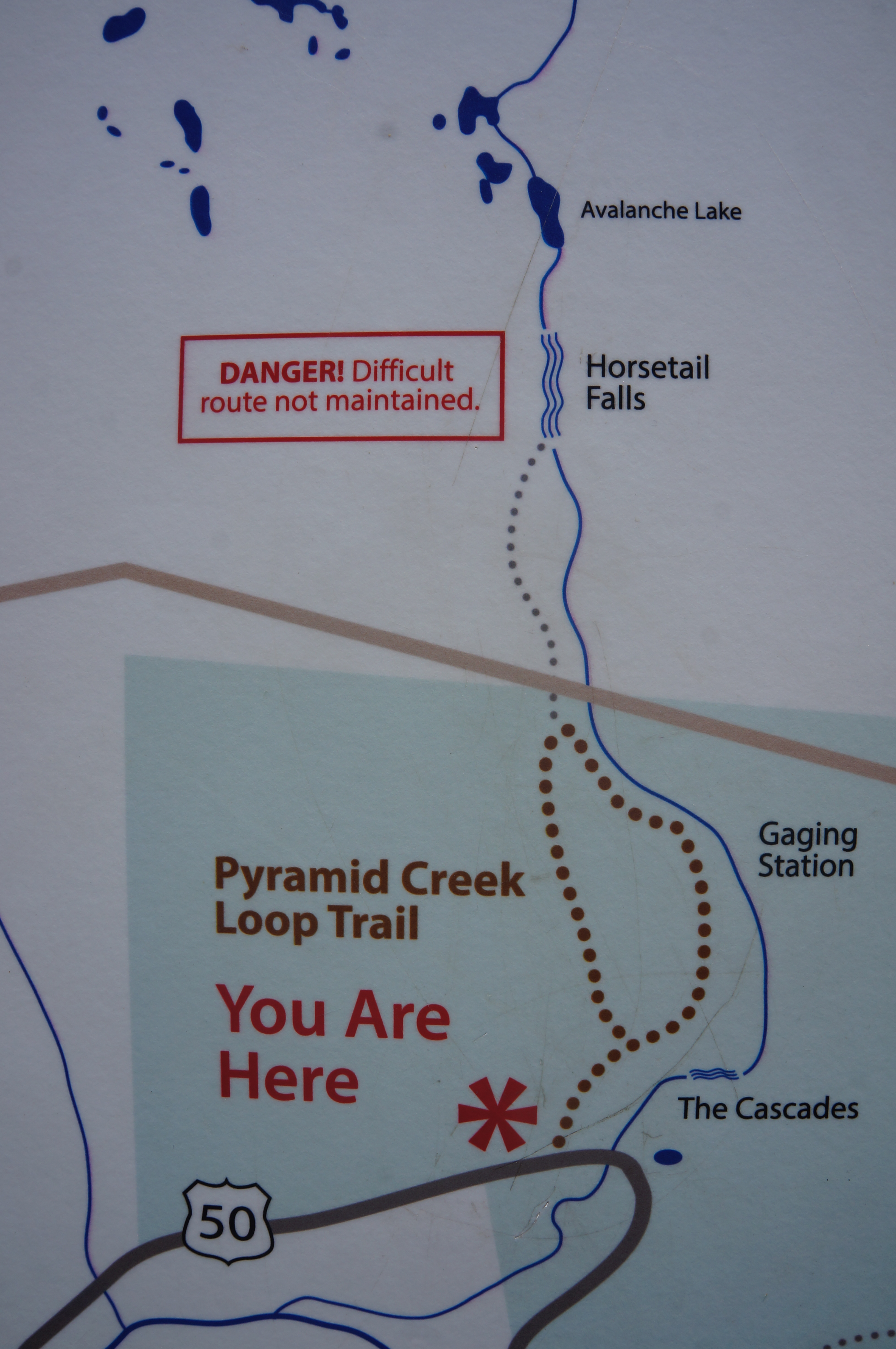
When ready, start on the Pyramid Creek Loop Trail, marked on a crude map found at the start of the hike. From here the path winds east, and soon north, briefly moving away from the traffic noise of Highway 50 before returning within sight of the busy thoroughfare. Pass a small cabin with a chimney off to the right, following the black trail blazes appended to woody pines. After around 250 yards, come to a stone slab set beside Pyramid Creek, with an initial set of small cascades. (Note: In late summer in a dry year, the creek flow can thin to a trickle.)
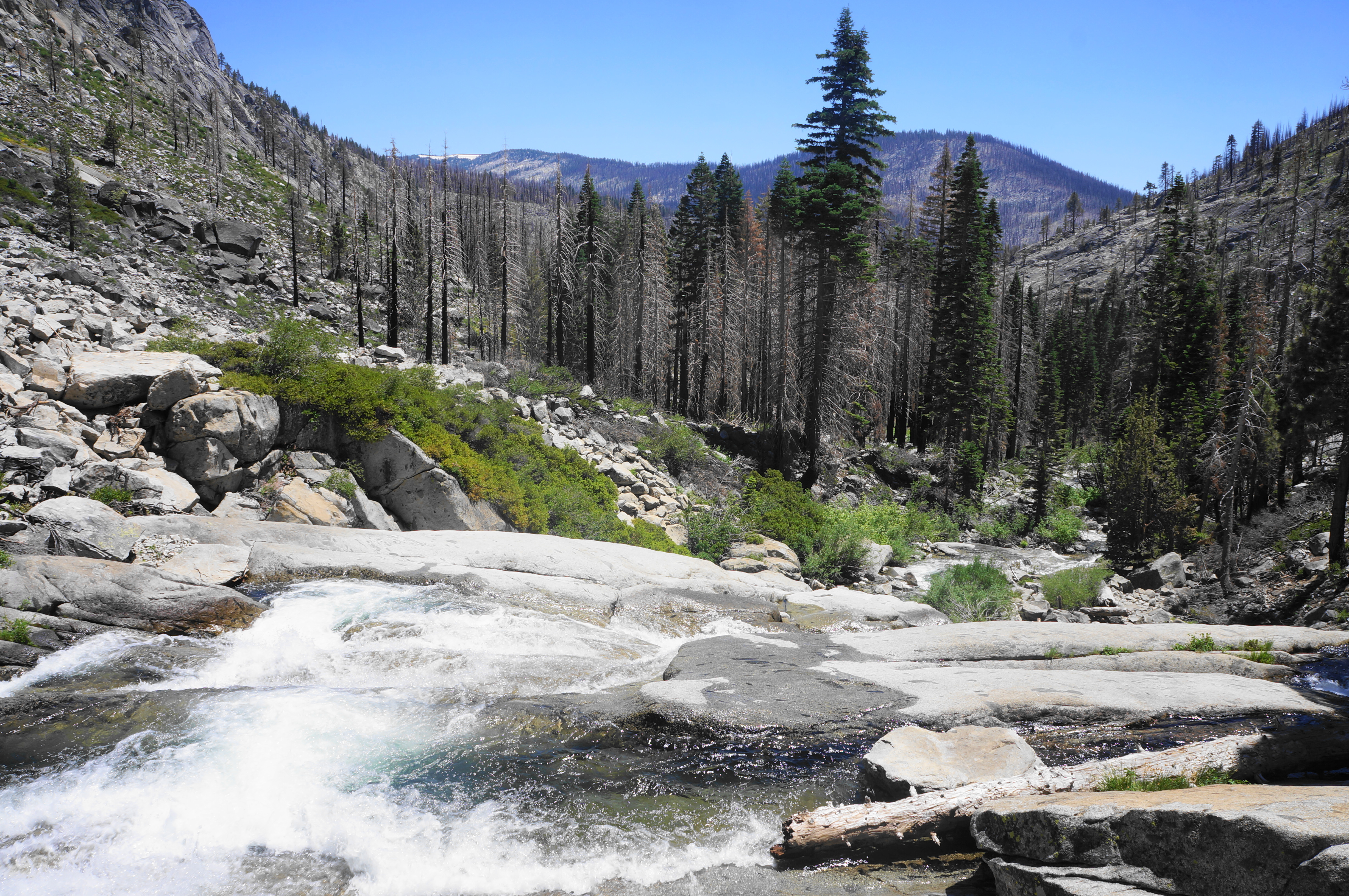
Still within earshot of the road, the Pyramid Creek Trail bears north and follows the stream, coming to another nice access point at around 2/10 mile. Cut away from the creek briefly and rise to a basin before returning to waterside views, but now in a forest with visible damage from the Caldor Fire. This historic wildfire burned more than 200,000 acres, cresting the divide and threatening the outer limits of the Lake Tahoe area, leaving a grim toll in its wake. It will take years, even decades, for this area to recover, as evidenced by the charred pine stands that remain along much of the hike.

At 3/10 mile, the loop portion of the Pyramid Creek Trail begins, with a lone sign pointing north toward the wilderness boundary and east to Pyramid Creek and cascade vistas. I recommend heading right first, taking the longer but more scenic option as it hugs the banks of gushing Pyramid Creek.


At this point, the trail becomes harder to follow, as slickrock replaces dirt, and the only markers of the route are the sporadic black blazes. Look for these tags to guide you up an initial slope and back to the creek, where one finds a shimmering cascade sliding down a granite face, a preview of the greater drops to come.

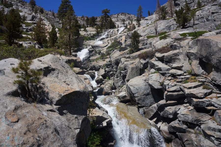
Parallel the creek as you climb to another level, exposed to the sun, and round a left-hand bend, now bearing north toward the main waterfall, visible ahead in the distance. The granite cliffs here form a bowl-shaped basin, nominally the end of Desolation Valley. Beyond, not visible, lies a playground of alpine lakes and scrubby knobs in the heart of Desolation Wilderness, easily one of the most popular backpacking destinations in the country.

Continuing to head toward the distant falls, the route comes level and follows something resembling a trail—more of a slight depression interrupted by slickrock, where the route disappears completely, except for those occasional black blazes. The proper route parallels the creek but largely stays out of sight of it, passing minor outcrops on the right.
At 9/10 mile, the Pyramid Creek Trail climbs noticeably away from the creek and up a manzanita-dotted hilltop. Bear right and crest a low ridge, coming back in view of the waterfall ahead. This spot, a popular resting point, marks the junction of the Pyramid Creek Loop with the start of the unmaintained route to Horsetail Falls.

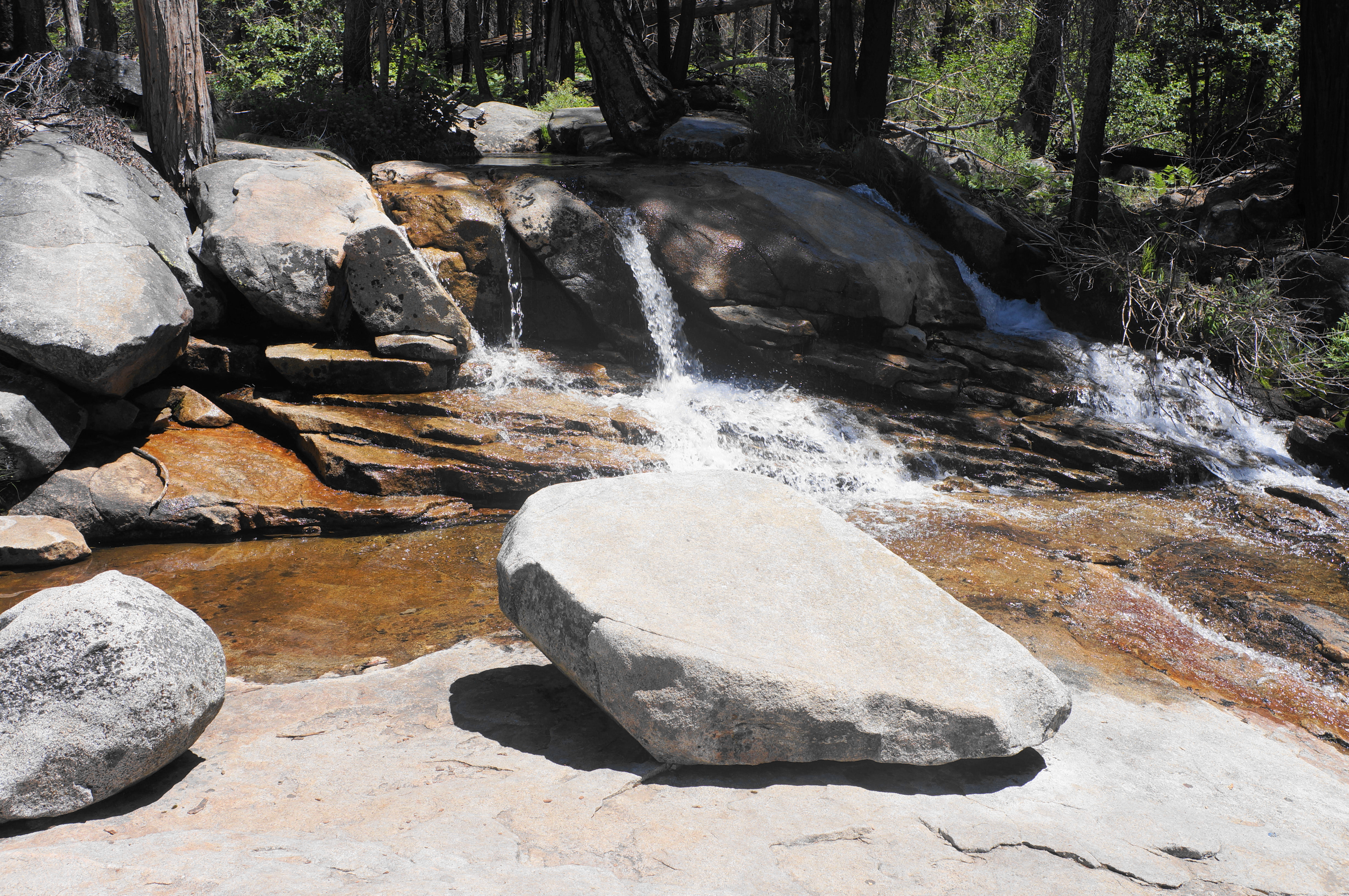
Head north on the unmaintained but well-travelled track, soon coming to a sign and trail register at the boundary of Desolation Wilderness. Sign in and fill out a free day pass here before continuing on. Thereafter the route starts out relatively clear before quickly threading out into a variety of social trails. Pick one, routing generally northbound. One option is to stay largely left, hugging granite slopes, well away from the creek; another, much brushier but perhaps more scenic, is to parallel Pyramid Creek. At one point, the trail passes a beautiful emerald pool, fed by a 2-foot cascade, that makes for a good swimming spot.

By 1.5 miles, the passage narrows as granite faces approach the creek on both sides, and denser shade cover offers respite from the summer heat. Come soon to a beautiful 20-foot, twisting plunge that marks the first of several scenic cascades that, in another park, would be considered waterfalls in themselves. By now one can reasonably say you have reached the ill-defined “base” of Horsetail Falls.

Beyond, head up and away from the creek, passing an overhang created by a massive boulder, then climb amid the brush to another vantage point with additional views of the cascades. The creek often splits into two separate threads here before rejoining at the base of the falls section.
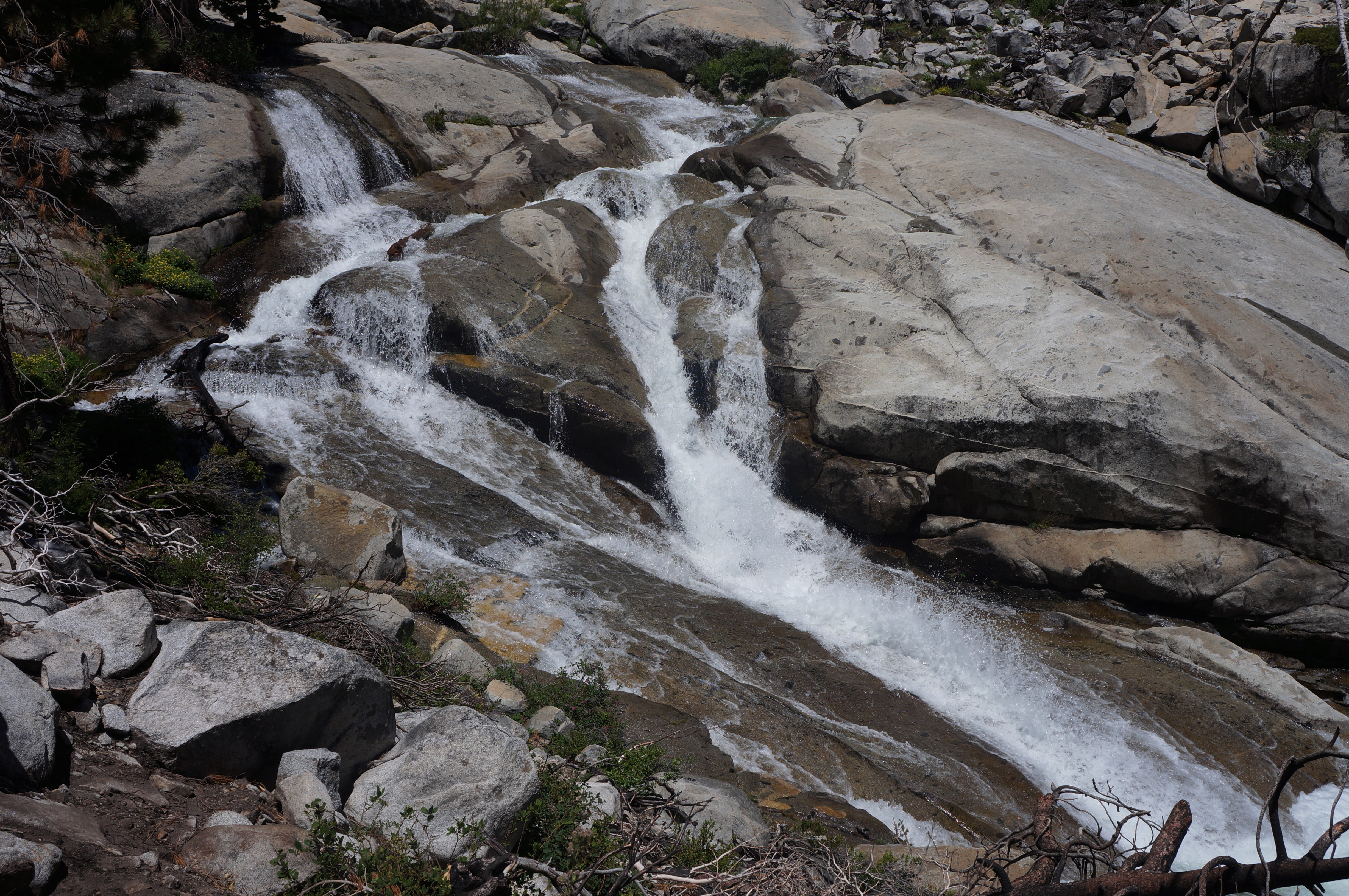
Another 1/10 mile takes one to the top of another 20-foot falls and an epic slot where, at certain times of year, the flow is such that the water forms a beautiful—and swimmable—pool, both above and below terrific cascades. This is a premier swimming hole on a hot day—but quite popular as well.
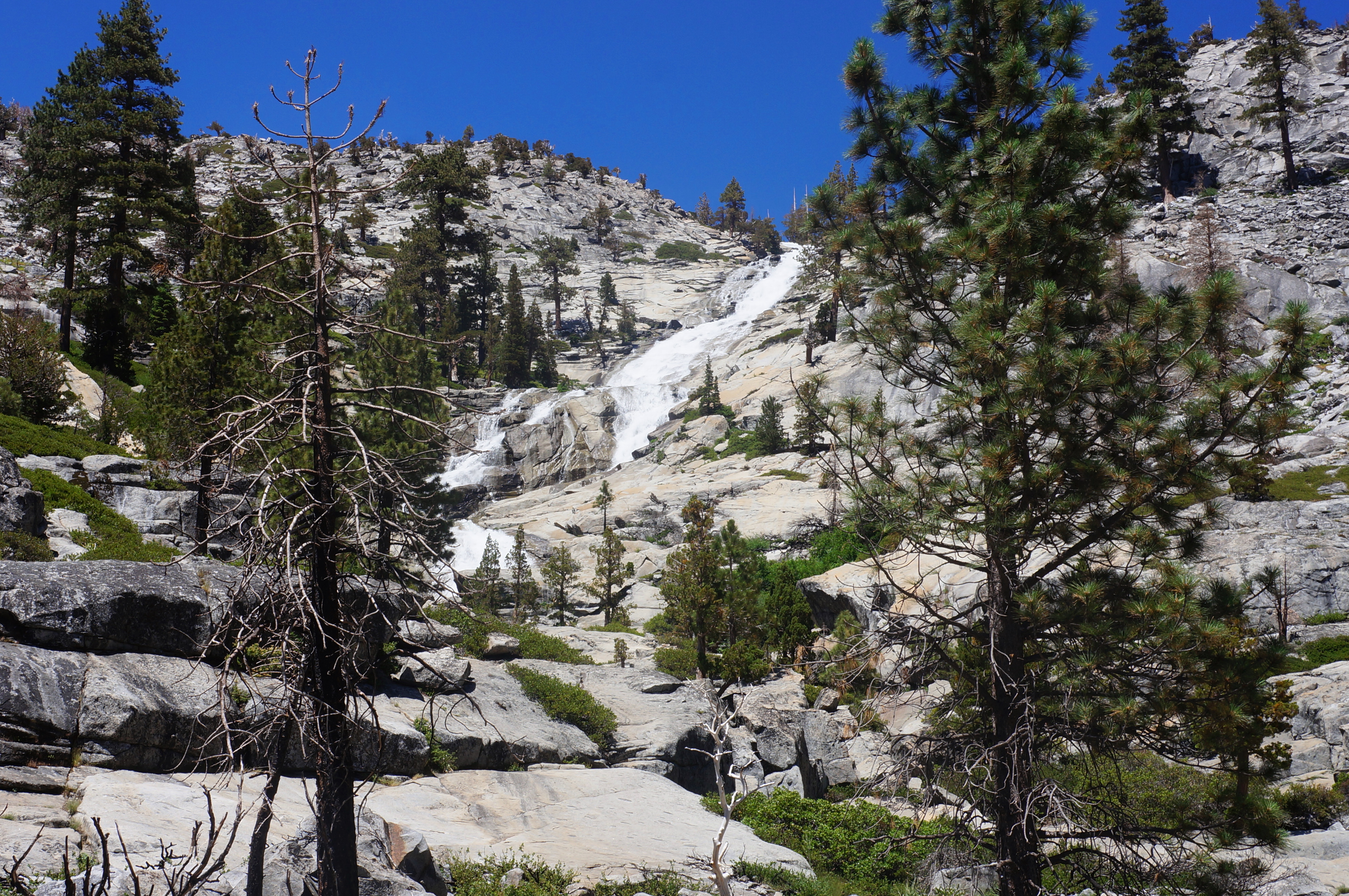


This is more or less the end of the hike for many. It is possible to continue farther to the base of what appears to be the “main” plunge—the section visible from Highway 50—and even beyond, with a steeper route that is basically an exposed rock scramble. (Note: This informal route leads up to Avalanche Lake, Ropi Lake, and beyond.)

For the rest (including yours truly), it is now time to return the way you came—to a point. Make your way back to the loop section at the manzanita-lined crest, except this time stay straight, following a shorter, mostly slickrock route back to the start. Look for black blazes and occasional cairns to guide the way again, descending a granite slope back to the initial (signed) junction. From here, follow the trail back through the burned area and down to the entry slabs along Pyramid Creek, before bearing right (west) to return to the trailhead.


Horsetail Falls is far from the easiest ½-day hike, but the short distance and relative accessibility of the route makes this one of the most popular treks in the Tahoe area.

Pingback: Top 10 Hikes in 2023 | Live and Let Hike