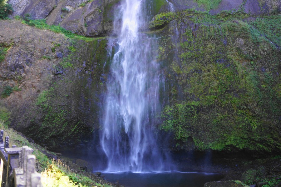
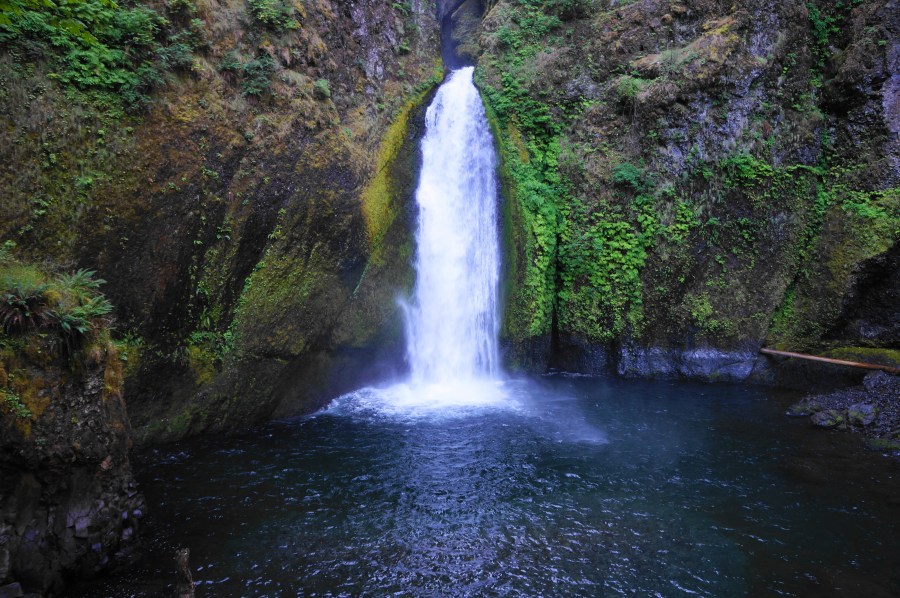
Natural Bridges (Samuel H. Boardman State Scenic Corridor, OR)

Natural Bridges, Samuel H. Boardman State Scenic Corridor, January 2021 As if the secret beaches, spectacular cliffside vistas, and crashing waves of the Pacific Ocean were not enough, Samuel H. Boardman State Scenic Corridor on the southern Oregon coast also boasts a number of natural bridges—iconic archways carved by the sea. The Natural Bridges viewpoint—at …

Continue reading Natural Bridges (Samuel H. Boardman State Scenic Corridor, OR)

Indian Sands Loop (Samuel H. Boardman State Scenic Corridor, OR)

Indian Sands Loop, Samuel H. Boardman State Scenic Corridor, January 2021 The Indian Sands area, situated near the middle of Samuel H. Boardman State Scenic Corridor, is a collection of crisp, windswept dunes, towering headlands, and thundering coves along the southern Oregon coast. Starting and ending at the Indian Sands Trailhead (mile marker 348.6 on …

Continue reading Indian Sands Loop (Samuel H. Boardman State Scenic Corridor, OR)

Thunder Rock Cove Loop (Samuel H. Boardman State Scenic Corridor, OR)

Thunder Rock Cove Loop, Samuel H. Boardman State Scenic Corridor, January 2021 Southwest Oregon’s Samuel H. Boardman State Scenic Corridor features some of the finest stretches of shoreline on the Pacific coast of the United States, and the short-but-spectacular Thunder Rock Cove Loop traverses one of its most picturesque pockets. The brief circuit skirts towering …

Continue reading Thunder Rock Cove Loop (Samuel H. Boardman State Scenic Corridor, OR)

Cape Ferrelo Loop (Samuel H. Boardman State Scenic Corridor, OR)

Cape Ferrelo Loop, Samuel H. Boardman State Scenic Corridor, January 2021 For 296 miles, the restless Pacific Ocean laps up against the Oregon Coast, producing chilly beaches, windswept rock outcrops, and imposing sea stacks. While some more peaceful, wide-open beaches may be found further south in California, the word that best describes the Oregon seashore …

Continue reading Cape Ferrelo Loop (Samuel H. Boardman State Scenic Corridor, OR)

Sun Notch Trail (Crater Lake National Park, OR)

Sandwiched between two precipitous peaks, the Sun Notch Trail is a short and scenic circuit hike in Oregon’s Crater Lake National Park that features five fine views of Crater Lake in quick succession. From the caldera rim, situated atop a cliff that drops more than 1,000 feet, hikers can see Wizard Island, the Phantom Ship, …

Continue reading Sun Notch Trail (Crater Lake National Park, OR)

Crater Lake National Park, OR

Oregon’s Crater Lake, America’s deepest lake, is also arguably its bluest. Fed entirely by rain water and snowmelt, this natural wonder and centerpiece of Crater Lake National Park was formed after the explosion of an ancient volcano—Mount Mazama—about 7,700 years ago. Volcanic features dot the landscape around the lake, including the Pinnacles, a set of …

Continue reading Crater Lake National Park, OR