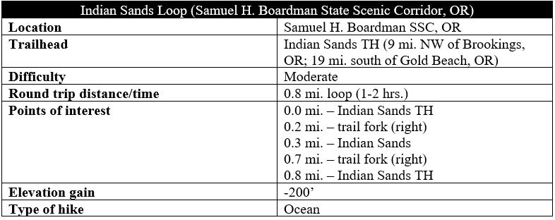
The Indian Sands area, situated near the middle of Samuel H. Boardman State Scenic Corridor, is a collection of crisp, windswept dunes, towering headlands, and thundering coves along the southern Oregon coast. Starting and ending at the Indian Sands Trailhead (mile marker 348.6 on Highway 101), a brief but beautiful circuit combines the sunny sands with thick forest cover, with terrific ocean views throughout much of the moderately-difficult hike.

The hike
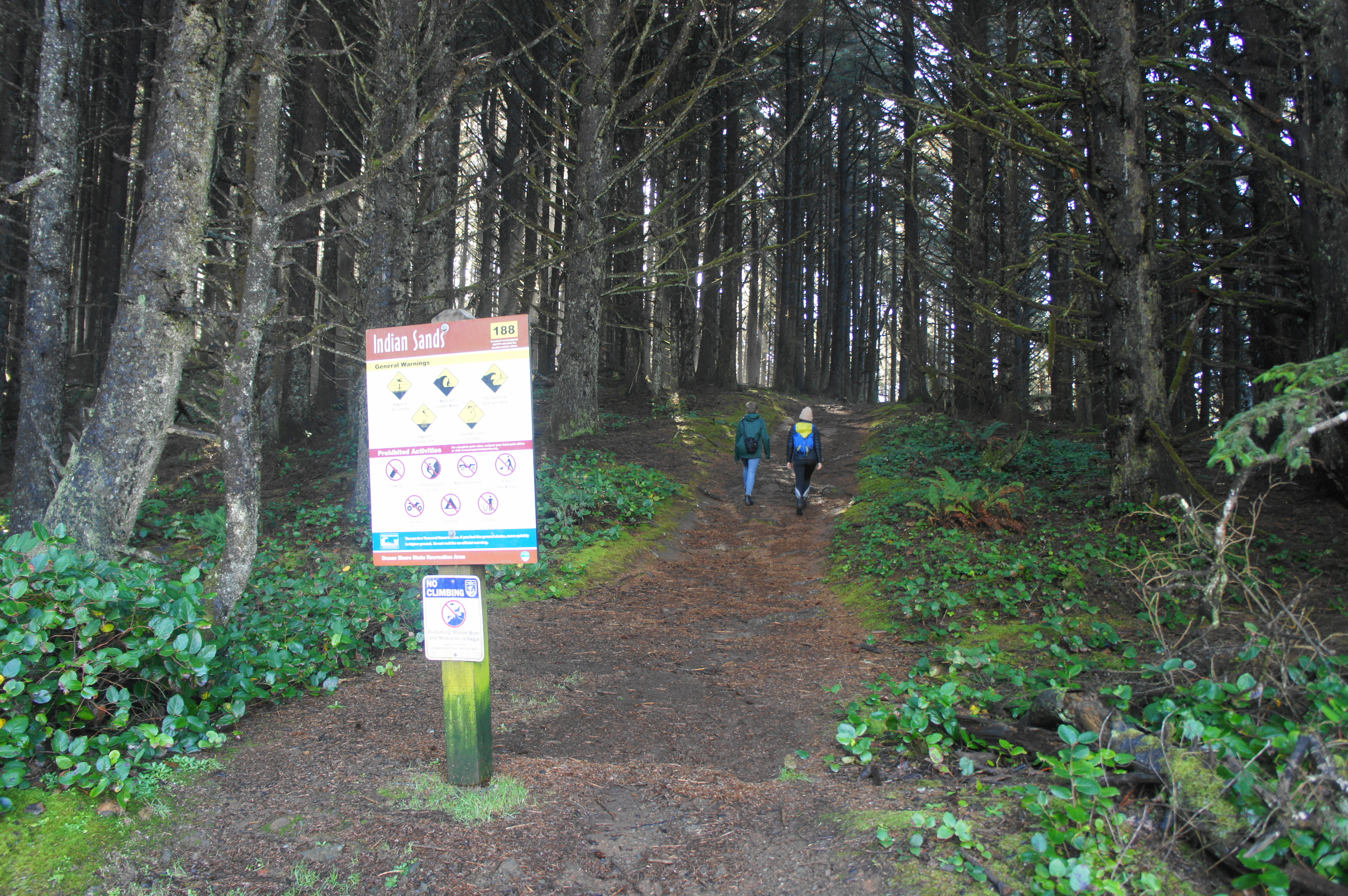
The large and gravel parking lot for Indian Sands is well-marked and situated roughly nine miles northwest of Brookings, Oregon and 19 miles south of Gold Beach in Samuel H. Boardman State Scenic Corridor. Park anywhere in the lot, but note that there are two trails that begin from this point: a wide, southbound route (after the entrance, to your left), which leads into a grove of tall Sitka spruce, and a northbound, narrower route, which is quickly enveloped by the dark forest. These are the start and end to the hike, respectively. Heading in the clockwise direction avoids a crushing ascent up a steep slope.
Taking the southbound track, the trail begins as a mild walk through an impressive stand of spindly conifers, with occasional ferns and salal dotting the understory. The modest descent, however, turns quickly into a sharp and precipitous decline, a drop that requires slow and careful deliberation, especially in the presence of mud or other moisture.
Beautiful spruce grove 
Approaching Indian Sands on the Oregon Coast Trail

The downhill ends at a trail junction about 2/10 mile; head right on the Oregon Coast Trail, a nearly 400-mile route that traverses the length of the state’s rugged coastline. Continuing to decline, but at a much more gently clip, the trail quickly emerges into a clearing, where the dirt gives way to clumpy sand and views of the Pacific Ocean open up to the west.

Heading in a northwesterly direction, the Coast Trail passes a neon-green sign on the right (titled “188”—used to signal one’s location in case of an emergency) and then leaves the dense stand of stubby shore pines behind. Ahead is the heart of Indian Sands, an attractive, cliffside shelf of gently sloping dunes. Here, footsteps fan out in nearly all direction, and the main track is temporarily difficult to discern. But this is also a fantastic area to explore.

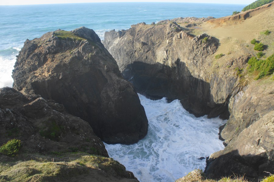
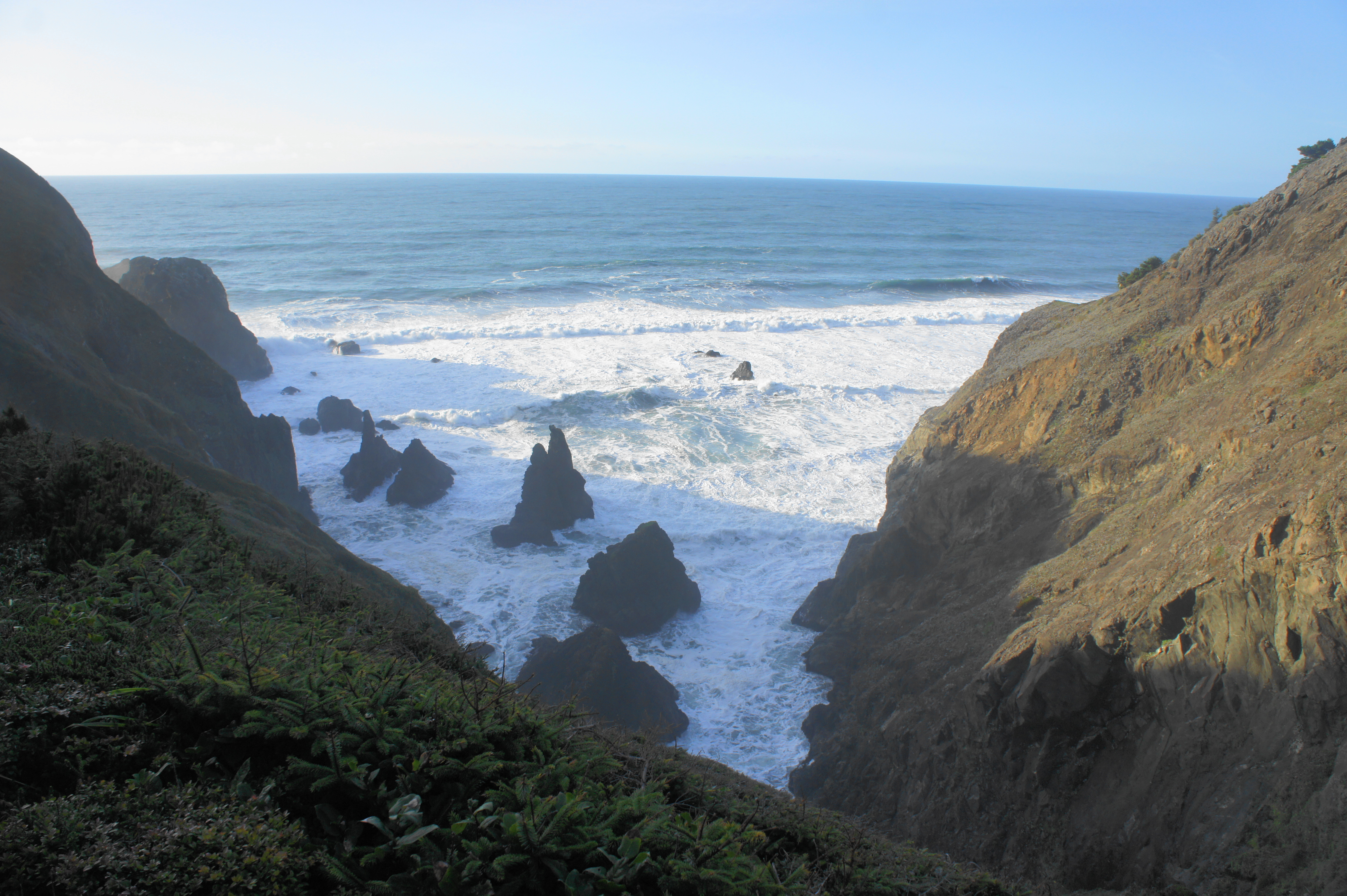
Heading left for five minutes leads to an outcrop with views of seaside natural arch to the south, while heading straight—out toward the ocean—leads to a series of rocky crags, separated by deep chasms, where the swirling sea creates thunderous waves and froth.
The onward track bears right (north), dropping to clear a sandy bowl before heading toward what appears to be a dusty passage between the main hillside and a rugged peninsula. The passage turns out to lead to a dropoff: the cliffs give way to another scenic inlet to the north, where a minor drainage drops sharply to the ocean, with several sea stacks just out to sea. One can also see north up the coast toward Thomas Creek Bridge, China Beach, Thunder Rock Cove, and the Natural Bridges area, although all are obscured by the jagged angles of the cliffs.

Even as the sands give way to impassable cliffs, the trail continues onward by cutting sharply to the right. Follow the footsteps leading up a narrow track that hugs the scrubby hillside, then runs through a trio of evergreen arches, formed by the windswept spruces that envelop the sea-facing slopes.


After the arches, hikers start to get a better view of the ravine to the east—your exit route. After a fourth, dark tree tunnel, the path crosses a minor stream that often bleeds into the trail itself. Now ascending steadily, the trail cuts left and enters a dim upland gully. Upon hearing the highway noise up ahead, the route forks; head right, leaving the Oregon Coast Trail behind—but not before briefly detouring to the left to observe a small waterfall, dropping gracefully into the wider creek below. (Note: Heading left, across the creek, leads toward Crook Point and Thomas Creek Bridge.)

From the junction, a network of trails bears uphill—all paths generally lead to the same place, although the trail that hugs the highway before contouring southwest is the easiest and avoiding unnecessary descents. Follow this track as it snakes through dense forest and returns to the Indian Sands parking area at the northbound entry point.
This moderately challenging loop hike takes roughly one to two hours to complete: that is, if you take the time to explore the Indian Sands area and its many wild features. Speedsters can certainly finish in less time, but what is the fun in that?

At the extreme south end 0f the Indian Sands area(south of the beautiful archway)is one of the great scenes of North America.
Pingback: Top 10 Hikes in 2021 | Live and Let Hike
Pingback: Humbug Mountain Trail (Humbug Mountain State Park, OR) – Live and Let Hike