Chain Lakes Loop (Mount Baker-Snoqualmie National Forest, WA)

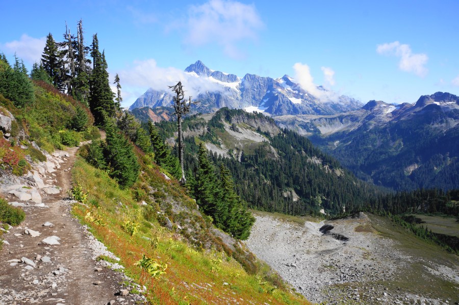
Iceberg Lake, Chain Lakes Loop, Mount Baker-Snoqualmie National Forest, September 2025 Traversing the highlands between two volcanic behemoths—Mount Baker (10,781’) and Mount Shuksan (9,131’)—the Chain Lakes Loop is a premier day hike in the northern Cascades of Washington’s Mount Baker-Snoqualmie National Forest. There are few dull moments, with open views of the two peaks and …

Continue reading Chain Lakes Loop (Mount Baker-Snoqualmie National Forest, WA)

Pemberton Creek Falls (Pemberton, BC)

Pemberton Creek Falls, Pemberton, British Coumbia, September 2025 Imagine living in a quiet neighborhood, set in picturesque mountains, with what one visitor described as “the waterfall no one knows about” in one’s backyard. The town is Pemberton, British Columbia—a much more modest alternative to bustling Whistler—and the waterfall is Pemberton Creek Falls, a 200-foot double-shot …

Continue reading Pemberton Creek Falls (Pemberton, BC)

Nairn Falls Trail (Nairn Falls Provincial Park, BC)

Nairn Falls, Nairn Falls Provincial Park, September 2025 Situated along the Green River, Nairn Falls is a popular destination between Whistler and Pemberton, British Columbia, notable for its frothy, multi-tiered drop through a narrow gorge. Nairn Falls Provincial Park is easily accessible from the Sea to Sky Highway (Route 99), though the parking area fills …

Continue reading Nairn Falls Trail (Nairn Falls Provincial Park, BC)

Marriott Basin Trail (Pemberton, BC)

Marriott Basin Trail, Pemberton, BC, September 2025 Set in a gorgeous bowl in the Cayoosh Range in western British Columbia, the Marriott Basin Trail is a less-crowded alternative to nearby Joffre Lakes. After a relatively ho-hum walk on logging roads, the route ascends through pine forests and glacial moraines to Upper Marriott Lake and Wendy …

Continue reading Marriott Basin Trail (Pemberton, BC)

Appalachian Trail – Virginia/West Virginia Section 1: Harpers Ferry to Keys Gap (Harpers Ferry National Historical Park, WV/VA)

Appalachian Trail, Harpers Ferry National Historical Park, October 2024 Having returned to the Washington, DC area last fall, my opportunities to get out hiking have unfortunately declined. But I have been able to resume my quest to achieve a long-term goal of completing all the nearby Appalachian Trail (AT) sections (see MD Sections 1, 2, …

Continue reading Appalachian Trail – Virginia/West Virginia Section 1: Harpers Ferry to Keys Gap (Harpers Ferry National Historical Park, WV/VA)

Top 10 Hikes in Briones Regional Park

Briones Crest Trail, April 2020 Spanning 1,600 acres in the East Bay’s Contra Costa County, Briones Regional Park is a wonderland of woody valleys, rolling hilltops, and sun-soaked ridges with panoramic views of the Berkeley Hills, Carquinez Strait, Mount Diablo, and Ygnacio Valley. Once owned by a 19th century rancher, the Briones Hills are now …

Continue reading Top 10 Hikes in Briones Regional Park

Hikes in Briones Regional Park (Lafayette Ridge Staging Area)

Lafayette Ridge Trail, Briones Regional Park, March 2020 Note: This is part of a multi-post series chronicling the many possible day hikes in the East Bay’s Briones Regional Park, a 1,600-acre tract nestled east of the Berkeley Hills, west of Mount Diablo, and south of Martinez and Carquinez Strait. I tackled these hikes over the …

Continue reading Hikes in Briones Regional Park (Lafayette Ridge Staging Area)

Hikes in Briones Regional Park (Springhill Road Staging Area)

Lafayette Ridge Trail, Briones Regional Park, March 2020 Note: This is part of a multi-post series chronicling the many possible day hikes in the East Bay’s Briones Regional Park, a 1,600-acre tract nestled east of the Berkeley Hills, west of Mount Diablo, and south of Martinez and Carquinez Strait. I tackled these hikes over the …

Continue reading Hikes in Briones Regional Park (Springhill Road Staging Area)

Hikes in Briones Regional Park (Reliez Valley Staging Area)

Blue Oak Trail, Briones Regional Park, November 2019 Note: This is part of a multi-post series chronicling the many possible day hikes in the East Bay’s Briones Regional Park, a 1,600-acre tract nestled east of the Berkeley Hills, west of Mount Diablo, and south of Martinez and Carquinez Strait. I tackled these hikes over the …

Continue reading Hikes in Briones Regional Park (Reliez Valley Staging Area)

Hikes in Briones Regional Park (Alhambra Creek Staging Area)

Hayfield Trail, Briones Regional Park, March 2020 Note: This is part of a multi-post series chronicling the many possible day hikes in the East Bay’s Briones Regional Park, a 1,600-acre tract nestled east of the Berkeley Hills, west of Mount Diablo, and south of Martinez and Carquinez Strait. I tackled these hikes over the course …

Continue reading Hikes in Briones Regional Park (Alhambra Creek Staging Area)