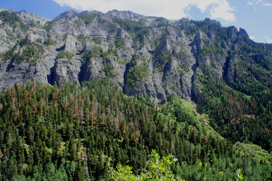
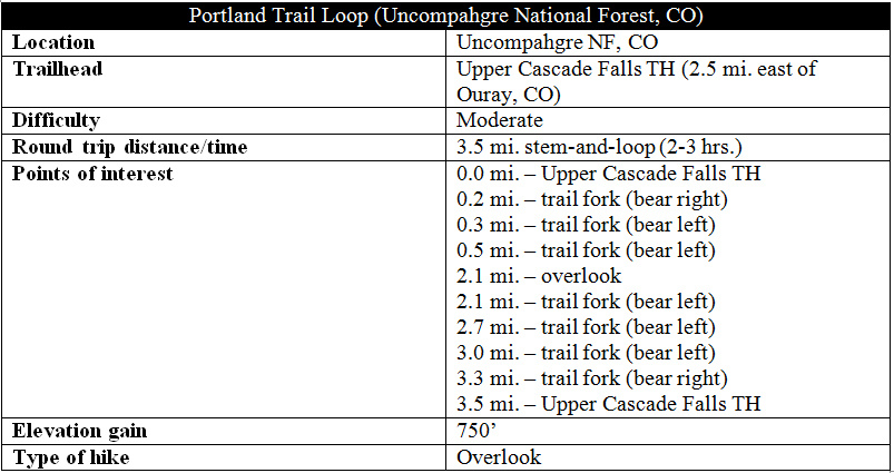
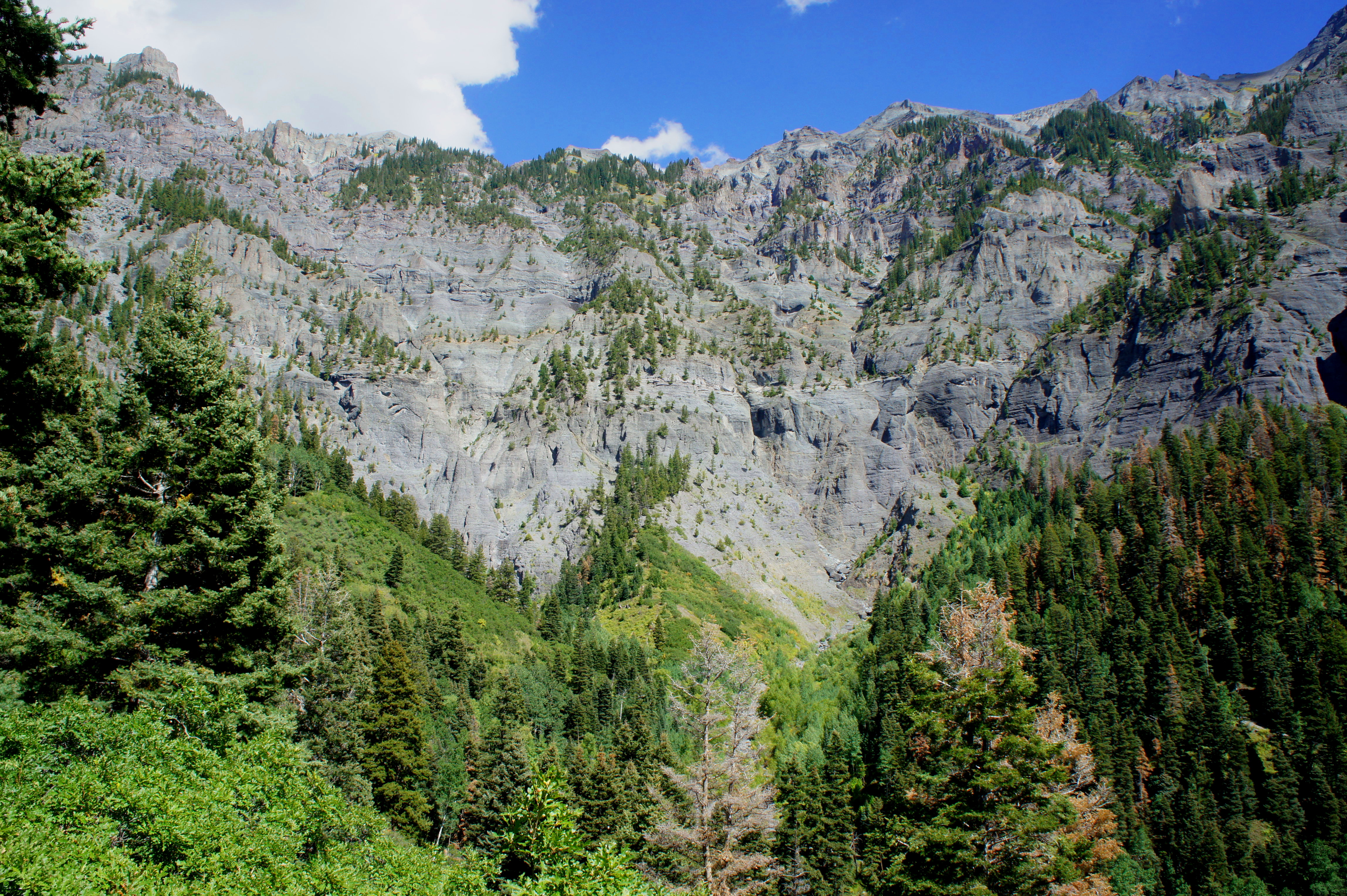
The Portland Trail, just outside Ouray in southwest Colorado, offers close-up views of one of the area’s most striking features: a highly sculpted, bowl-shaped cliff face known as the Amphitheater. While composed mainly of grayish, volcanic rock, this west-facing wall is illuminated in the evening light, bringing out the whites, yellows, and purples and allowing visitors to examine the intricacies of the glacier-carved valley. At just 3.5 miles with a very gradual ascent of 750 feet, the Portland Trail is also one of the Ouray area’s easiest hikes. Hike this loop in mid-afternoon, waiting for the morning shadows to fully lift, for the best views of the colossal Amphitheater.

*Check out more hikes in Colorado, Uncompahgre National Forest, or the Ouray area.*
The hike
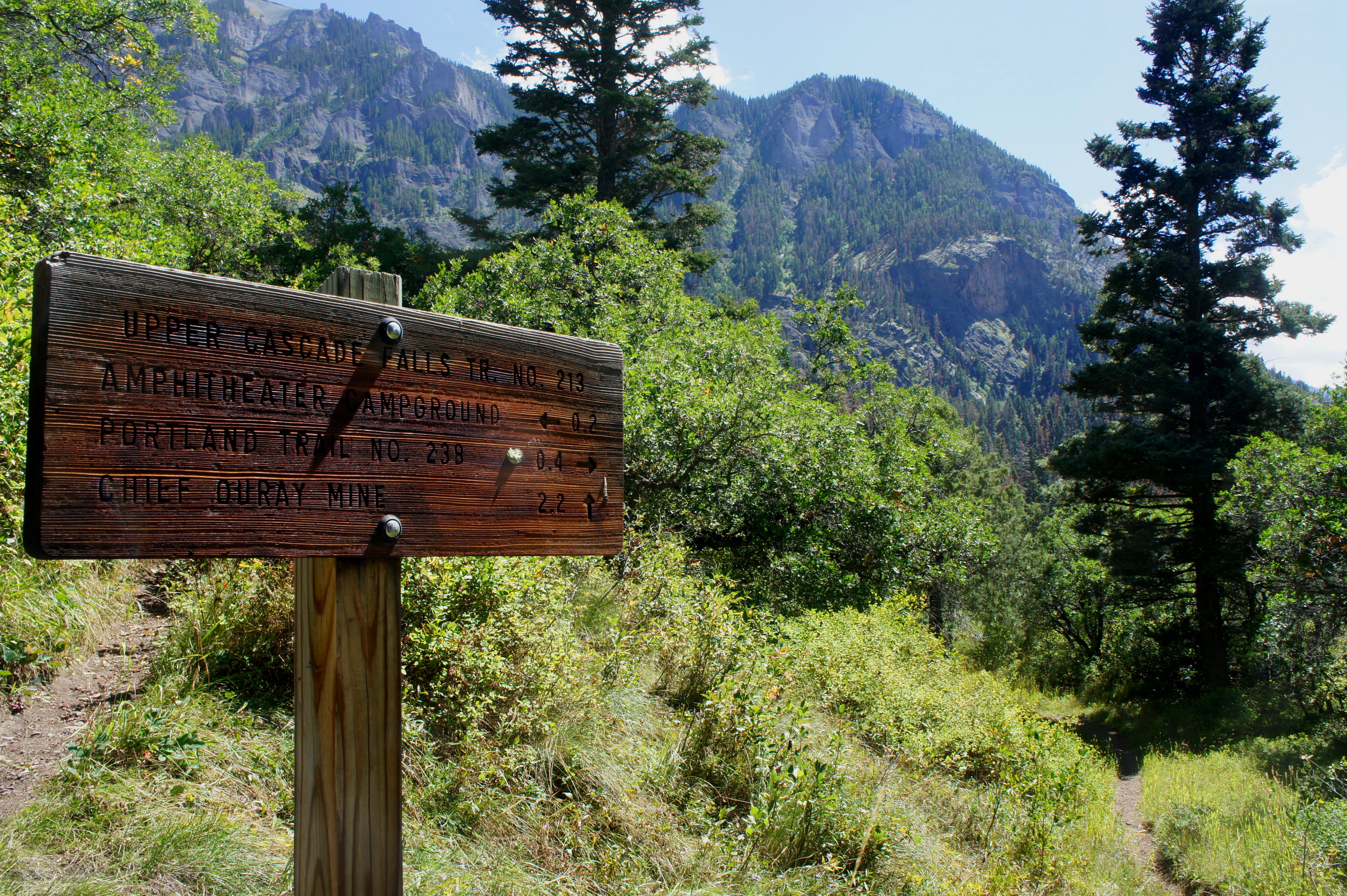
Like many hikes in the area, the Portland Trail Loop has many possible approaches. The official Portland Trailhead seems like the most logical place to start, but it is situated along an unpaved road that may be impassable for some vehicles. The better alternative is to begin at the Upper Cascade Falls Trailhead, located at the end of the Amphitheater Campground Road, a paved drive that breaks with Route 550—a.k.a. the “Million Dollar Highway”—after two hairpin curves heading south from Ouray. Drive up the road and stay left at each junction, eventually ending at a dead-end parking lot surrounded by a sea of trees; this is the trailhead. There is a large hiking map and weathered trail sign at the south end of the lot. (Note: for visitors staying at the Amphitheater Campground, it is a short walk to the trailhead.)
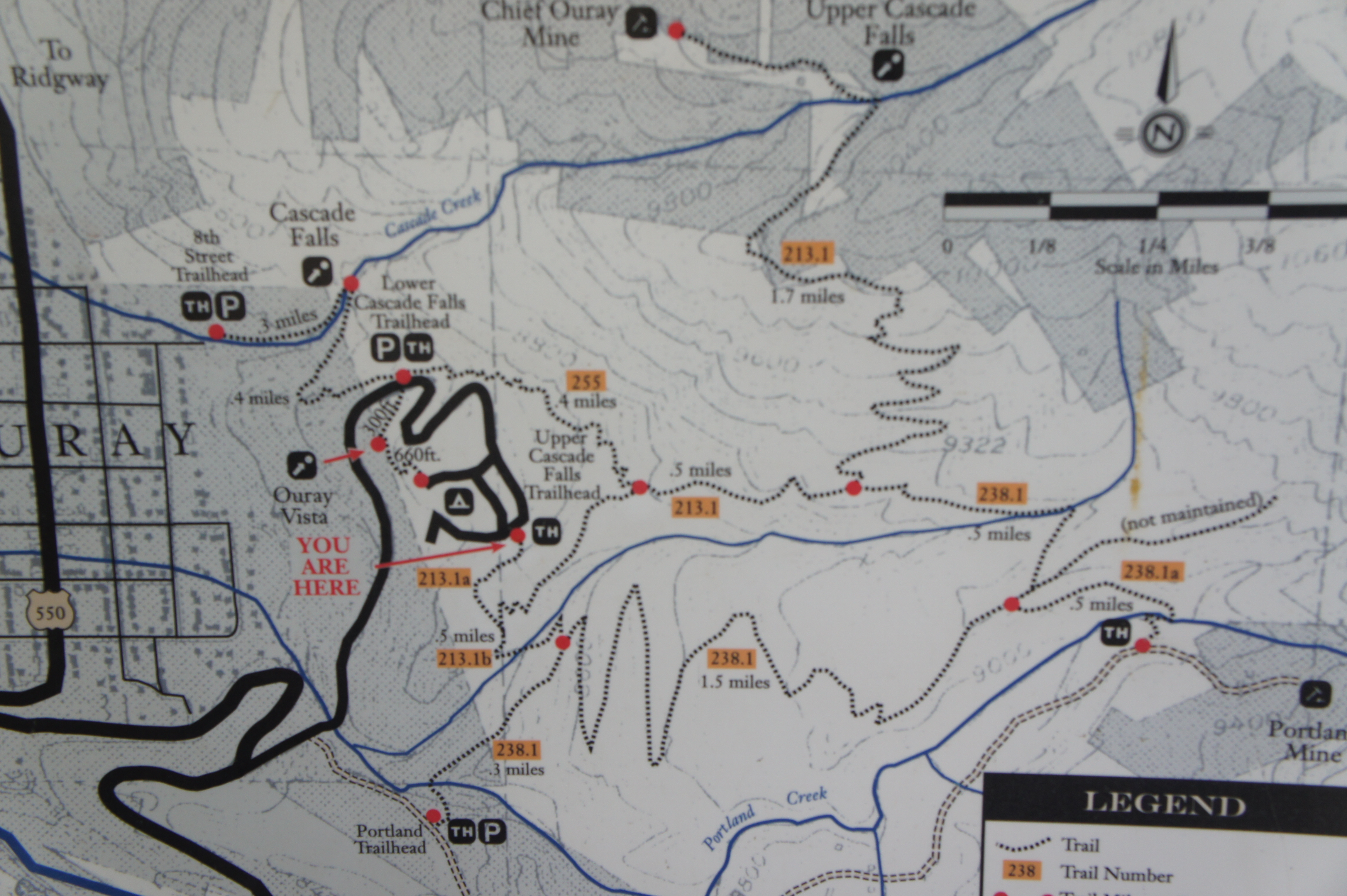
The hike begins by gently tracing a brushy hillside for around 2/10 miles, when you will encounter the first of several trail junctions. Stay right, following the arrow pointing to the Portland Trail, which is from here a little over 1/3 mile away. (Note: The trail heading left—the Upper Cascade Falls Trail—will be your return route. Hiking in a counter-clockwise direction, this route offers the path of least resistance, climbing up the gradually-sloping Portland Trail, while saving the steeper Upper Cascade Falls Trail for the downhill.)
Leaving the trail fork behind, the singletrack path must first descend to clear Little Portland Creek before it begins the 750-foot climb to the scenic overlook of the Amphitheater. Meandering around a left-hand bend, the trail drops downhill to meet a second trail junction at 3/10 mile; stay left at the fork. (Note: The trail heading right descends sharply down to Ouray.)
Winding amid tall firs and ponderosa pines, the trail descends to cross the (usually dry) creek bed of Little Portland Creek at around 0.45 mile. Immediately after, the ascent begins, starting with a steep but brief haul up the southern bank. A third junction is reached just beyond the ½-mile mark: hang a left on the Portland Trail. (Note: There is a small hand-drawn map at the junction with accurate trail distances.)
For the next 1.5 miles, the footpath will climb gradually to the hike’s high point at around 9,200 feet. The ascent is made relatively painless by the development of long, gently-sloping switchbacks, the first of which you will round at about 0.57 miles. Occasional clearings offer nice views looking back toward Ouray, Hayden Mountain (13,206’), Potosi Peak (13,786’), and the Canyon Creek Valley. As the trail ascends higher, aspen trees pop up amid the mixed conifers, and the trail traverses hillsides of scrub oak and mountain laurel.

After briefly descending to clear a minor ravine at 1.7 miles, the trail climbs again to round a left-hand bend then levels off. The floor drops off to the right, giving way to a U-shaped valley carved by Portland Creek. The opposite flank, part of an unnamed ridge that reaches 12,300 feet, has been heavily mined, as it is rich in ores of all varieties. (Note: It is evidently possible with some good eyes, better than mine, to spot some crude mining infrastructure, long abandoned, along the grayish slopes.)
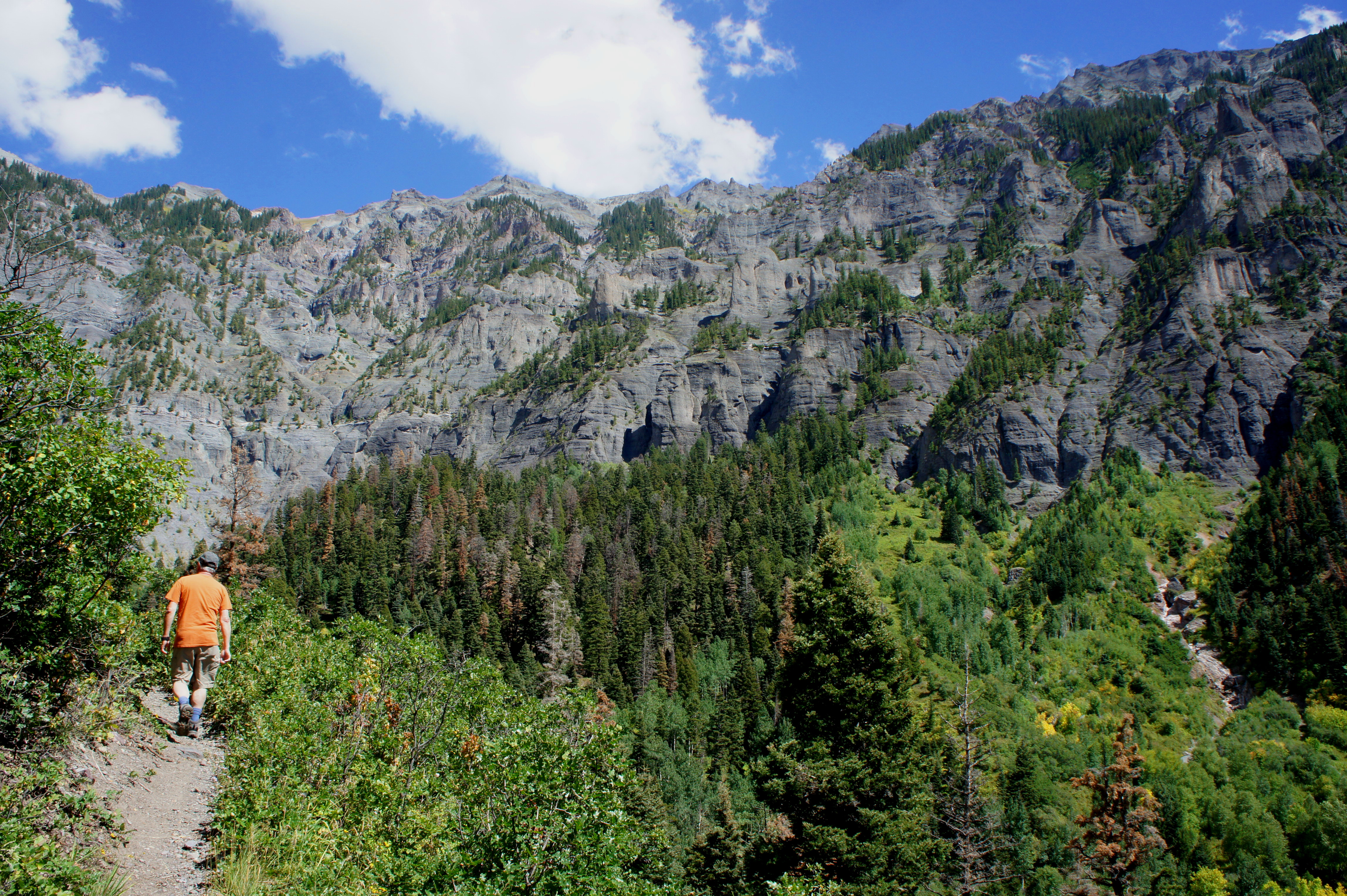
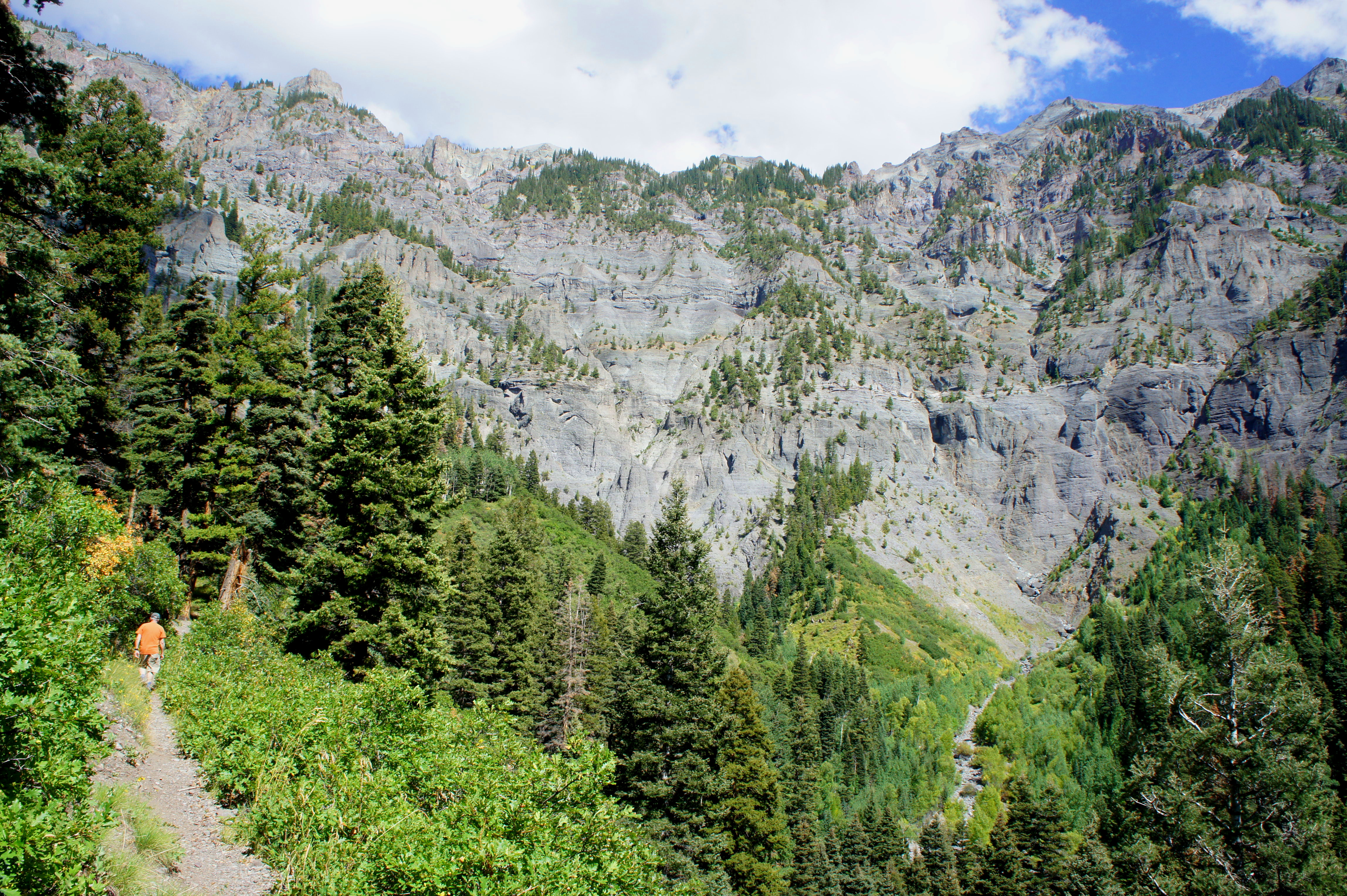
At around two miles, the trail passes a stand of aspens and makes a final push to the scenic overlook, marked with a small sign. Here one can see much of the curved Amphitheater in its full splendor. Intricate vertical cuts add texture to the soft, volcanic walls of the cliff face, which was formed by a receding glacier, leaving behind what is called a “glacial cirque.”

The stony mass is capped by an unnamed peak that tops out at 13,111 feet and bounded to the northeast by peak aptly named Bridge of Heaven (12,368’), which can be reached on a very difficult hike from the Horsethief Trailhead north of Ouray. Dense stands of conifers and sporadic grassy pastures fill the bottom of the cirque, adding allure to the mountain nirvana.
After enjoying a snack break at the viewpoint, continue northward on the Portland Trail as it reaches the highest point on the hike at around 2.2 miles. Here the trail forks again: a ½-mile spur trail continues straight ahead, leading to the Portland Mine and Portland Mine Road, while the loop continues left. Plunging back into the trees, the Portland Trail begins a sharp descent as it approaches the Little Portland Creek drainage. At 2.4 miles, the rocky trail crosses the creekbed—likely dry in summer—then traces the northern bank as it continues downstream. Crossing a series of tributaries, the trail bounds up and down before meeting a signed junction with the Upper Cascade Falls Trail at 2.7 miles. Stay left on the main track, also the main thoroughfare for hearty hikers heading to and from Upper Cascade Falls and the Chief Ouray Mine.
Now at least 150-200 feet above Little Portland Creek, the subsequent section offers terrific views toward Ouray and Hayden Mountain (though they will be cast into shadows in the late afternoon light).

The trail drops at a noticeably steeper incline than the gradual ascent and leads to another junction at around mile 3; stay left. Winding through a series of sloping bends, hikers will reach the original trail junction at 3.3 miles; take a right, and follow the gentle slope back up to the Upper Cascade Falls Trailhead, your start and end point.
As mentioned before, this 3.5-mile circuit is one of the easiest hikes in the area and will likely take 2-3 hours to complete.
Extra credit
Pair this afternoon hike with a morning jaunt on the Ouray Perimeter Trail, which forms a 4-5 mile circuit around Ouray and features multicolored cliffs, waterfalls, deep canyons, and panoramic views of the San Juan Mountains. Check out the hike description here.

So good to see you back out west, Andrew! We are hoping to finally get to this area late summer/fall next year. It seems we are in CO in the spring and it is too early to hike in most of the higher elevations. We’ve only been to Ouray with a motorcycle so we are really looking forward to hiking this area.
Indeed! Alas, only for a fleeting moment, as I am now back out east again. But I savor the trips when I can get them.
Pingback: High Bridge Trail (Box Canyon Park, CO) | Live and Let Hike
Pingback: Top 10 Hikes of 2016 | Live and Let Hike
Pingback: Trading Post Trail (Red Rocks Park, CO) | Live and Let Hike