
Barry’s Island Trail, situated at the end of the paved road in Bighorn Canyon, was my third hike of the day and second in the park. I added a foray into the Medicine Creek/Davis Creek drainage, which was terrific but not recommended for those without some off-trail navigation abilities. I also encountered the most bighorn sheep I have ever seen; they were in a batch of 20 or so along the main trail and were seemingly not afraid of humans. A cool sight in the canyon bearing their name.
The Barry’s Island Trail is a curious little route, rounding not an island but a peninsula of sorts, a sharp hairpin bend in the Bighorn River in the middle of Montana’s Bighorn Canyon National Recreation Area. While the canyon walls in this part of the park are not as tall, the orange-, red-, and tan-hued limestones and sandstones make for a colorful palette. This is also a relatively rare hike that is at river/lake level, and the mildly meandering path offers distant views to Pryor Mountain and the Bighorn Mountains. Expect to take 2-3 hours to complete this pleasant hike.


The hike
To reach the trailhead, drive Wyoming Route 37 (Bighorn Canyon Road) to its end, rising up into Montana and following a side canyon down to river level, near the mid-point of Bighorn Canyon National Recreation Area. Park at Barry’s Landing, which boasts a large parking area and popular marina. Here, close to the vault toilets on the north side, a sign indicates the start of the Barry’s Island Trail, a 4.4-mile stem-and-loop that ventures north from here.


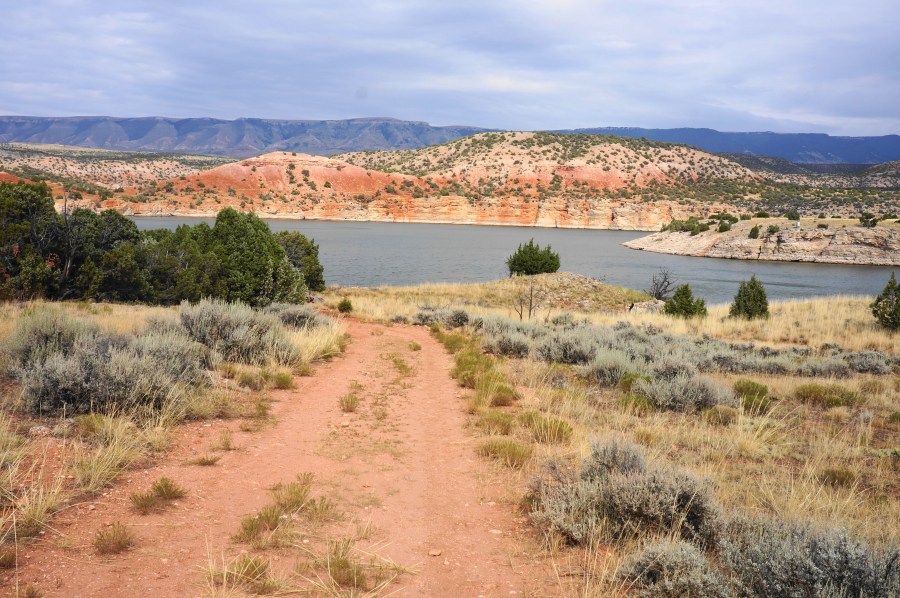
The wide double-track treads across ruddy soil and through a pinyon/juniper landscape, with a broader section of Bighorn Lake (a manmade expansion of the underlying Bighorn River) visible off to the east. The rosy crumble of the Chugwater Formation gives way to the gray- and peach-colored Madison limestone just above the water’s edge.

Pass through a gate, then round a left-hand corner and skirt tree-lined Chain Canyon, which was once used as an escape route for cattle rustlers in the late 19th century. After clearing the sandy drainage and inlet, the trail bears eastward and comes within a stone’s throw of the main lakeshore, with the flattop of Barry’s Island visible ahead.


From here the Barry’s Island Trail skirts the lakeshore and rises to a narrow neck between Wassin Canyon and the main gorge. This is also the start of Barry’s “Island”—actually an oval-shaped peninsula. Here there is also a junction, with the route left heading toward Medicine Creek Campground (boat-in only) and the Davis Creek drainage. Head right, however, to begin the Barry’s Island section, with the trail quickly forking again, signaling the start of a 1.5-mile loop.


Take a left to follow the circuit clockwise, with views to the Wassin Canyon inlet, and, further in the distance, some much higher limestone cliffs with a chunky thumb jutting out into the main canyon. The vistas improve as the trail rises, but eventually the track turns inland and splits again. Take the “upper trail” to the left for the best views, tracing up a partly graveled track to a higher shelf with eastward vistas across Bighorn Canyon, with the Bighorn Mountains beyond.


Traverse the hightops—peppered with prickly pear cactus, yuccas, and cryptobiotic soil—eventually coming to a grassier section where the trail is more faded but still traceable. Then ascend a sharp grade to a spot with a full panorama look. Round a dip and eventually return to connect again with the “lower trail.”

With the lake now down to the left, descend mildly and then follow the level trace back to the start of the loop section. Say goodbye to Barry’s Island as you return to the saddle. The adventurous can bear right to check out Medicine Creek Campground and the pretty Davis Creek drainage. But most will want to head left, retracing your steps for 1.4 miles to return to Barry’s Landing and cap off the hike.


Pingback: Cottonwood Creek Trail to Melody Falls (Bureau of Land Management, WY) – Live and Let Hike
Pingback: Top 10 Hikes in 2024 – Live and Let Hike