
From the Bighorn Canyon area, I set out across the Bighorn Mountains and visited Little Bighorn Battlefield before leaving the Rockies behind. Traversing a whole lot of nothing between Buffalo, Wyoming and the Black Hills, I made it to Devils Tower National Monument in the late afternoon. The Sturgis biker crowds were out in full force, but the brief 1.6-mile hike around the tower was pleasant enough, with some beautiful evening views across the Belle Fourche River valley.
The world’s most famous example of a phonolite porphyry, Devil’s Tower in northeast Wyoming was once described as an “upthrust against the gray sky as if in the birth of time the core of the earth had broken through the crust and the motion of the world was begun.” Known locally as “Bear Lodge” to Native Americans, the volcanic protrusion became known as Devil’s Tower after another poor case of translation by a US Army Colonel in 1875. Today the site receives more than 500,000 visitors annually, many seeing the tower as part of a trip in the broader Black Hills. There are a handful of hiking trails in the park. One of the shortest—and closest to the iconic butte—is the Tower Trail, a 1.60-mile circumnavigation that is paved but with lots of mild ups and downs. In addition to tower views from all angles, there are a couple nice overlooks of the Belle Fourche River valley along the way.

The hike
Reach the trailhead by following the main road through Devils Tower National Monument to its end, set in the high hills dotted with ponderosa pines. The parking area and Visitor Center are 3.4 miles from the turnoff on State Highway 24. Once you’ve arrived, make your way to the east side of the circle loop, toward the impressive monolith. Here a pair of trails form concentric circles: the Tower Trail and the longer and more rugged Red Beds Trail. If you only have time for one, I recommend the former, which offers a closer look at Devils Tower (though with significantly more crowds).
The first part of the hike is wheelchair-accessible, with a paved path heading toward the rubble. Follow the bends up to a gazebo (dubbed the “Interpretive Plaza”), viewing platform, and junction with interpretive signs about the tower. The views improve after turning right at the fork, staying on the paved path (the Red Beds Trail bears left here). Here hikers come closer to the famed volcanic monolith of Close Encounters of the Third Kind lore. Round another set of bends and come to a second fork. This is where the loop portion begins.
Head left to follow the Tower Trail in a clockwise direction. The tread turns from concrete to asphalt and is no longer technically wheelchair-accessible (although potentially possible to maneuver). After heading north for about 1/10 mile, come to a spur that veers right, dipping into a boulder field at the base of Devils Tower. This is the best view so far of the igneous intrusion, the origins of which are still debated.

Continue on the Tower Trail as it bears north and east through the ponderosa forest, with some obscured views beyond. Now set pretty far back from the tower, the trail ascends briefly in one section and comes to a spur to a partial view of the valley below. The route then rises a bit further, then returns back in the direction of the tower, rounding to its eastern flank. Weaving amidst the boulders, come eventually to the hike’s halfway point, denoted with a small sign.


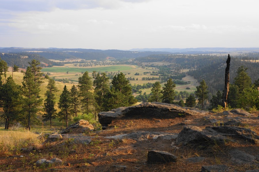
Soon come to a view of “The Window,” a 300-foot alcove where part of the tower has eroded. After this the trail climbs again over a notch and comes close the wall itself. Bend away from the base once again and pass a set of benches on the left, with the woods thinning and offering a better look down to the lovely valley, streaked with beds of red mudstone. The views improve further at a worthy spur trail heading left at around the 1-mile mark. Here one can see east to Black Hills of eastern Wyoming (but not quite the higher tops of South Dakota).


Continue as the trail bears westward through patches of pines. Pass the remains of an old stake ladder and admire the enduring views of Devils Tower from yet another angle, then enjoy additional unobstructed vistas southeast across the Belle Fourche basin.


The final stretch of the loop bobs and dips through a chunky boulder field set below the tower. Soon enough the Tower Trail returns to the junction that kicked off the loop portion. Take a left, then another, to follow the stem section back down to the parking lot and Visitor Center. This caps off a 1.6-mile hike.


I recently re-watched “Close Encounters” and it was (as I remembered from the first time) a pretty terrible movie. Still, it will be forever associated with this site.