
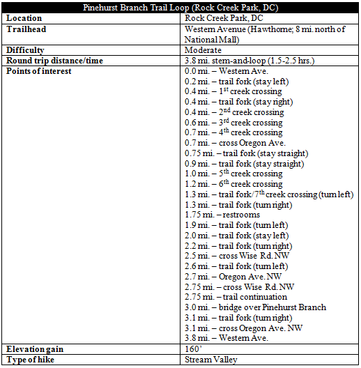
While firmly within the District of Columbia, Rock Creek Park’s “wild northern section” sees relatively sparse use due to its distance from the city center. All the better: not only is bigger and better than the park’s crowded southern reaches, but the area provides a sense of solitude almost unheard of in a major American metropolis. The 3.8-mile Pinehurst Branch Trail Loop described below offers a taste of this charming and densely-wooded area, beginning and ending at DC’s northwestern frontier with Maryland.
The hike
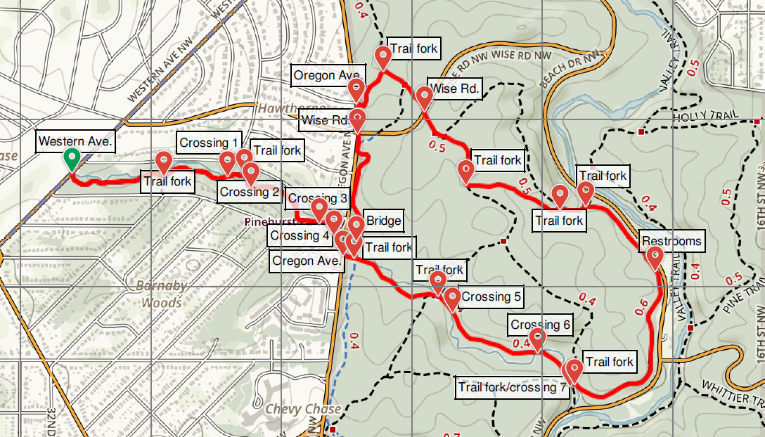
The loop hike takes off from the quiet and sleepy community of Hawthorne, nestled in the northwest corner of DC. Bounded by Pinehurst Parkway Park and Rock Creek Park to the south and east and Maryland to the west, Hawthorne is so isolated—by city standards—that many longtime DC residents have never heard of it.
All this, of course, makes the neighborhood an ideal starting point for a hike characterized by its quiet seclusion. The Pinehurst Branch Trail begins along Western Avenue NW between Beech Street and Aberfoyle Place, marked with a small wooden sign. Park anywhere along the shoulder (or take the E6 bus from the Friendship Heights Metro Station), and lace up your hiking boots for the dusty path ahead.
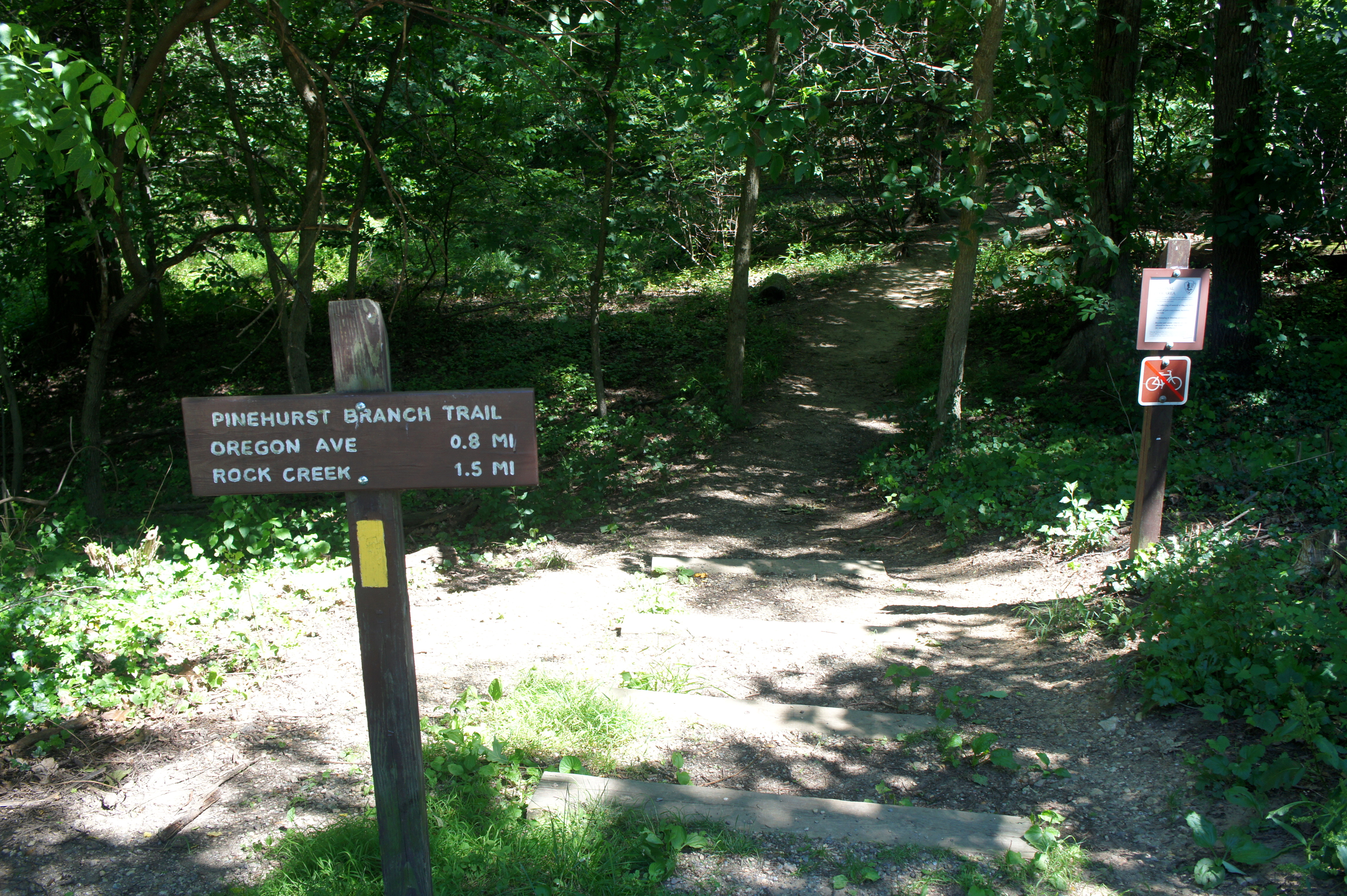
The narrow trail begins by dropping down four wooden steps and plunging into the woods, passing under a canopy of poplars, chestnuts, oaks, maples, and ubiquitous beech trees. The trail’s namesake stream is visible on the left after about 100 yards. Partly graveled, the trail widens slightly then climbs at a modest clip to meet the first trail junction at ¼ mile. Stay left, paralleling a densely-vegetated ravine on the right before traversing a short bridge over a Pinehurst Branch tributary.
For the next couple hundred yards, the trail parallels Pinehurst Branch, littered with gray-white stones that have washed downstream. At about 1/3 mile, pay close attention as the trail drops down to cross Pinehurst Branch for the first time; while the more obvious trail continues straight along the south bank, yellow blazes direct hikers across the stream. Barring adverse weather conditions, the traverse is short and straightforward.
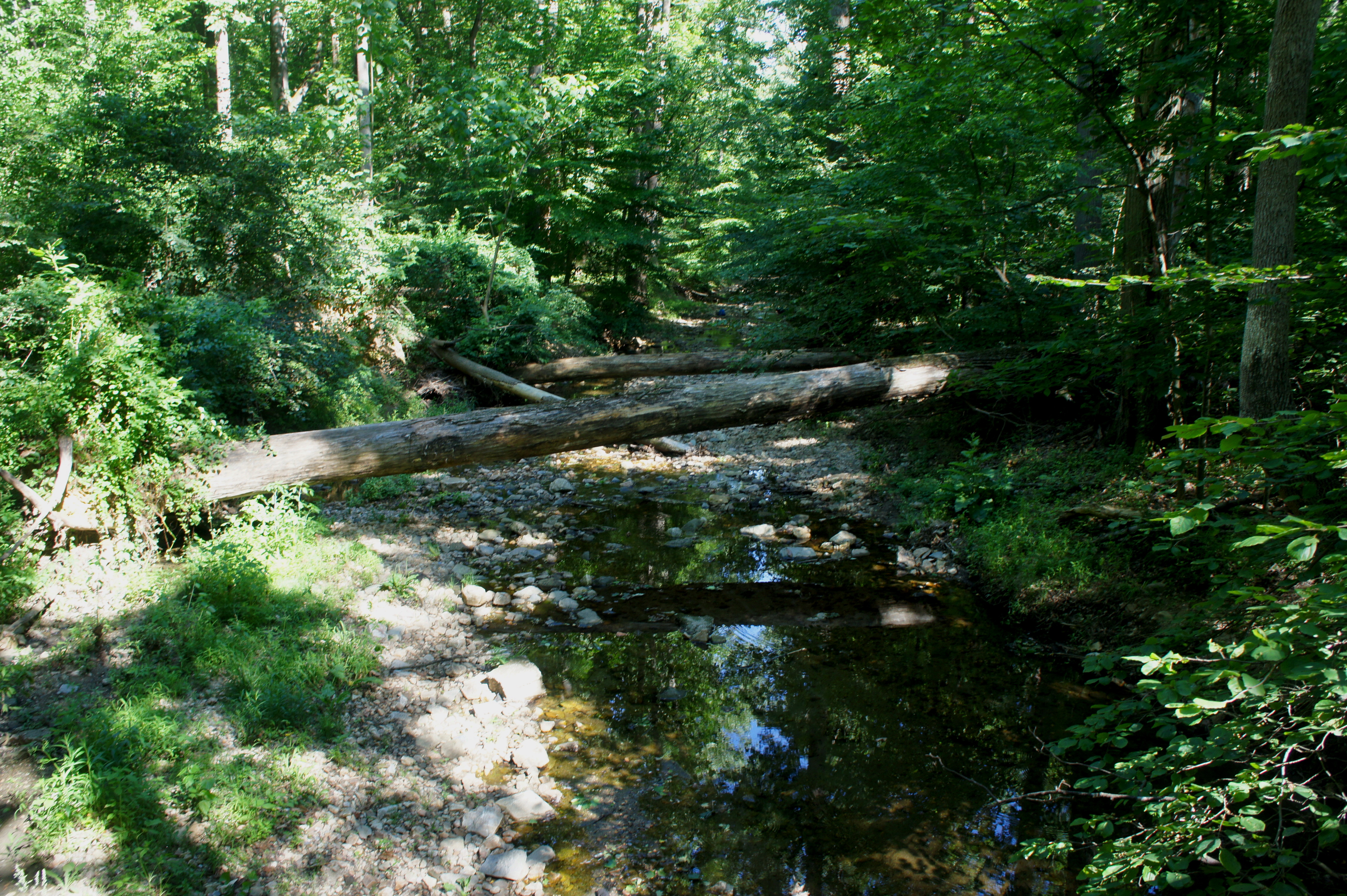
Time along the left bank is fleeting; stay right at the route junction (a connecting trail leads left to Beech St.), then cross Pinehurst Branch a second time, returning to the south shore. This crossing is one of the more interesting: the high bank on the right has become the deposit point for a smattering of large boulders, which, at the time of writing, were further enveloped by a large, fallen tree.
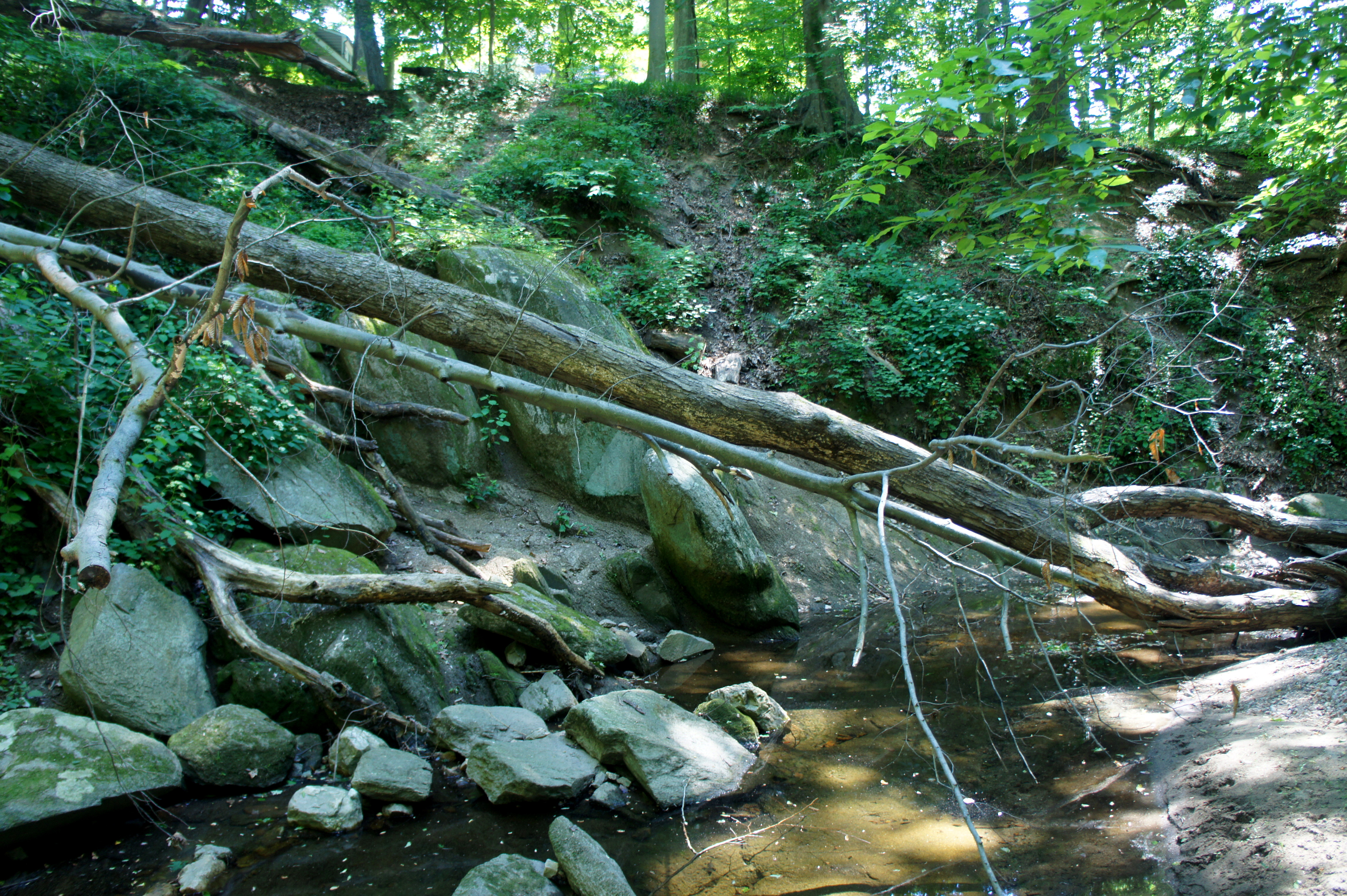
By now, the right flank of the stream valley has developed into a relatively steep hillside largely devoid of undergrowth. The Pinehurst Branch Trail follows the south slope for 1/10 mile, then suddenly cuts right as it ascends partway up the hillside. Stay left at the junction with an unofficial spur trail, then cross a minor drainage. At 6/10 mile, the path crosses Pinehurst Branch a third time. Again, it lasts only a moment, as the trail curves right and, with Oregon Avenue now in sight ahead, crosses back to the right bank.

At 7/10 mile, carefully cross Oregon Avenue, leaving Pinehurst Parkway Park behind and entering Rock Creek Park proper. Within a minute of reentering the woods, the trail bisects the paved Rock Creek Trail (which you will return to later). Stay straight on the Pinehurst Branch Trail.
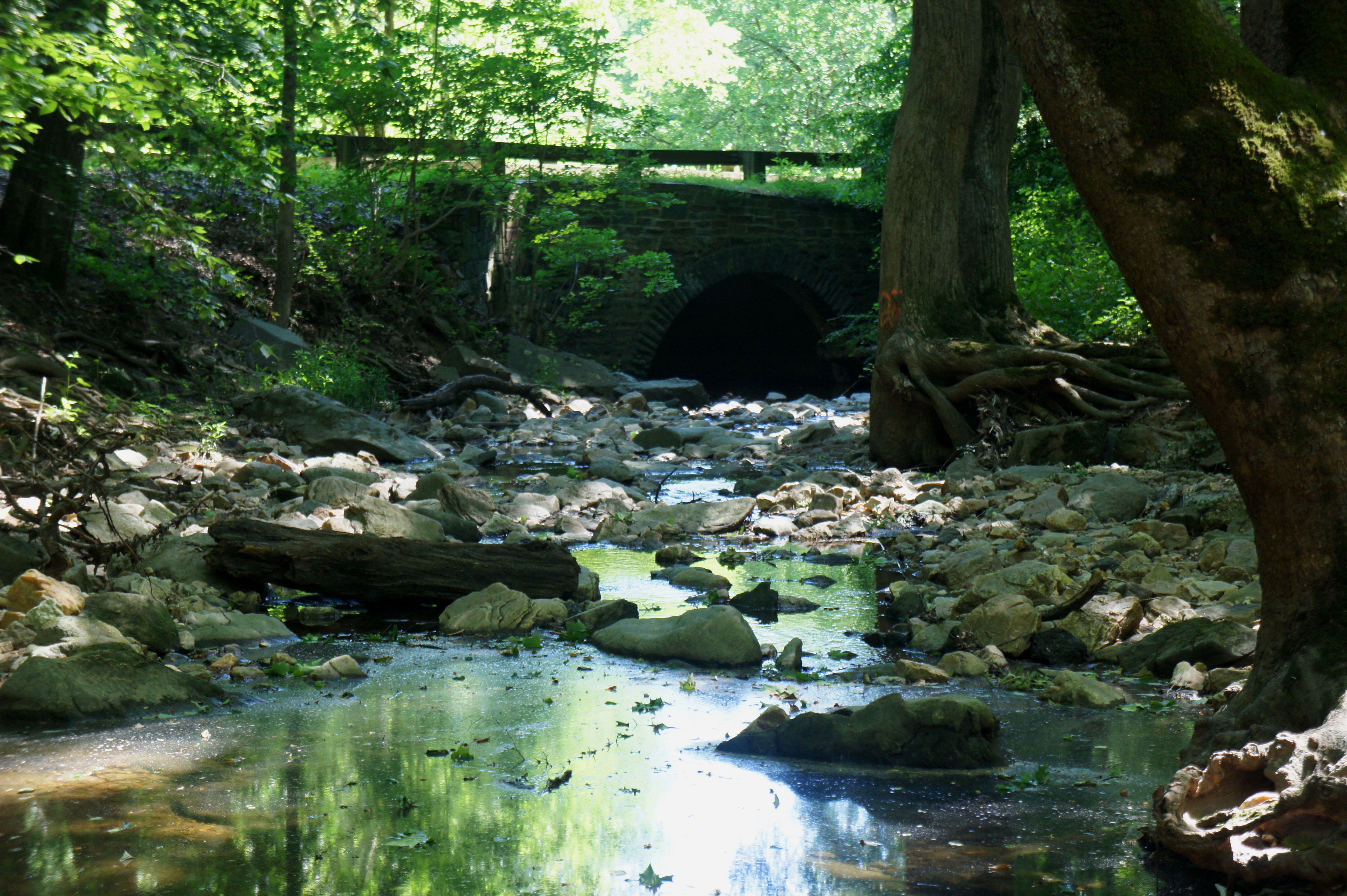
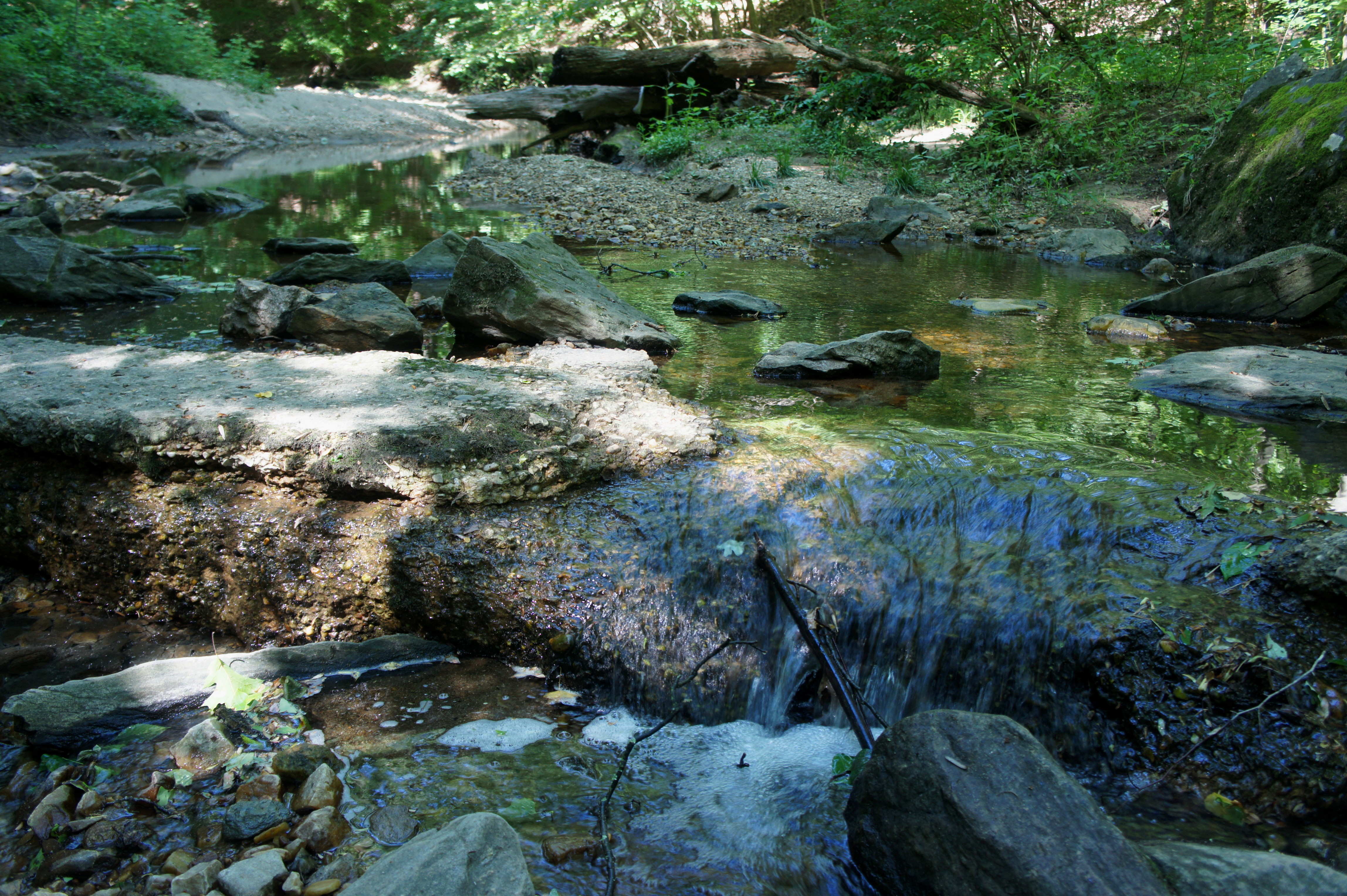
After a brief absence, the stream reappears at around 8/10 mile, and the path forks again at 9/10 mile. Stay straight again on the roughly east-west Pinehurst Branch Trail as it crosses the north-south bearing Western Ridge Trail. The sandy trail crosses Pinehurst Branch a fifth time at about the one-mile mark, where the stream drops leisurely over a small shelf, forming a pretty mini-cascade of sorts. After 2/10 mile on the left bank, the trail crosses the stream again at 1.2 miles; this time, the creek is more than 20 feet wide before it funnels into a manmade, partly concrete channel. From here, the trail widens and is partly graveled as it approaches Beach Drive in the heart of Rock Creek Park.
Just before reaching the road, however—at 1.3 miles—it’s time to leave the Pinehurst Branch Trail behind. Bear left at the four-way trail junction, then immediately cross the creek for a seventh and final time. Ascend the steps along the north bank, then turn right at the next junction, embarking on an unnamed trail bearing east.
More so than any other part of the hike, this section offers the best workout as it climbs steadily while rounding a left-hand bend. Beach Drive and Rock Creek Park’s picnic area #8 appear down through the trees on the right. Now bearing northward through dense thicket, the narrow trail drops into a ravine, climbs again, then clears a second gully. Spur trails bearing right and left are ubiquitous—stay straight as the main path heads northwest, passing behind some restrooms at picnic area #10 at around 1.75 miles.

Minutes later, the trail climbs steadily to a point offering a partly-obscured view of Rock Creek (situated across Beach Drive) from above, then cuts west and descends to a real trail junction. Faced with the binary choice of left or right, bear left at the fork, ascending gradually through a fern-covered gulch.
This trail—effectively a dusty and weathered former road—climbs up the ravine, passing a subtle spur on the right at 2.0 miles and terminating at the Western Ridge Trail at 2.2 miles. Bear right on this prominent hiking thoroughfare through Rock Creek Park, which, true to its name, follows high ground as it snakes north and west toward Wise Road.
Cross the road at 2.5 miles, entering the hike’s most confusing section: many maps show the Western Ridge Trail intersecting with a southwest-bearing path shortly past Wise Road…but for all intents and purposes, this path does not exist. An alternative is to head up the trail for about 1/10 mile, then bear left on a subtle, social trail that also bears southwest but gradually fades as it approaches the edge of the park. Nonetheless, the path offers a route up and out of a fingered ravine and within sight of Oregon Avenue on the right, effectively ending at the junction of Oregon and Dogwood Street. From here, follow the left-hand side of Oregon down to the intersection with Wise Road, where you can pick up the paved Rock Creek Trail. (Note: It is also possible to skip this section altogether by bearing left on Wise Road at 2.5 miles, but, with blind curves and the lack of a clear shoulder, this is discouraged.)
Now around 2.75 miles into the hike, follow the Rock Creek Trail as it snakes around a small ravine, then bounds southward. At 3.0 miles, the paved path crosses a bridge over Pinehurst Branch then completes the loop as it joins again with the Pinehurst Branch Trail. Bear right at the junction, retracing your steps—over Oregon Avenue and across the first four crossings of Pinehurst Branch—back to the trailhead at Western Avenue in Hawthorne. (Note: As shown in my Map My Hike track, there are a couple of possible deviations along the way.)
All told, this loop—at a leisurely space but with minimal stops—should take around 1.5-2 hours. While not exactly action-packed, the 3.8-mile stem-and-loop offers solitude nearly unparalleled in one of America’s largest urban parks.

Great website!! If you’d like some more hikes with photos, let me know! I’d love to know how you set the site up, too. For example, Soapstone/Melvin Hazen loop with Western Ridge extension.
Tom Beckman 202-248-9608