

Although named for the tall, wily trees populating the area, the real highlight of the Yellow Poplar Trail in Maryland’s Gambrill State Park is the ubiquitous, yellow-green ferns seemingly present at every turn. Straddling Catoctin Mountain—the easternmost ridge of the Appalachian Mountains in Maryland—the Yellow Poplar Trail offers some limited vistas but, sparsely traveled even on a busy summer day, is more notable for its peaceful serenity. At 7.1 miles, the circuitous trail is also Gambrill’s longest.

The hike
The Yellow Poplar Trail intersects with Gambrill Park Road at a number of places, but there is probably no place better to start than the parking area at the High Knob Nature Center, situated just off Gambrill Park Road about one mile from the entrance. (Note: A stone’s throw from Frederick, Maryland, Gambrill State Park is about an hour’s drive from both Baltimore and Washington, DC.) While the nature center is only open by appointment, the parking area across the street has around 10-12 spots. (Note: Additional parking is available farther south at South Frederick Overlook in the High Knob Area.)
Head north along the road to reach the start of the Yellow Poplar Trail, situated just past the intersection with Gambrill Park Road on the left. Several paths take off from here, including the Black Poplar Trail and Green Ash Trail; follow the yellow blazes north, as Yellow Poplar shares a track with Green Ash while paralleling the road on the right. Occasional pines and hemlocks dot the path amid a sea of otherwise deciduous trees.
At 2/10 mile, the trail passes in front of a building labeled on the maps as the “visitor center”—but looks rather like a maintenance shed. (Note: I think the real visitor center is across the street?) The footpath continues north for another 200-300 yards before it crosses over to the east side of Gambrill Park Road, where it finally plunges into the woods and out of sight of cars.
At 4/10 mile, Yellow Poplar—briefly sharing a track with the Black Locust Trail—breaks with its trail brethren after passing under a set of power lines. Shortly after the split, hikers pass again under the power lines, then again a third time within minutes. The third crossing reveals a sea of bracken ferns, the first good look at the hike’s most striking flora.
Aside from the ferns, the most conspicuous other plant along the hike is mountain laurel, widely found in the Appalachians. This evergreen shrub blooms in May and June, producing bunches of pink or white flowers. Mountain laurel is particularly noticeable throughout the next section, as the Yellow Poplar Trail rounds a corner at 7/10 mile and follows an old road toward a junction with the blue-blazed Catoctin Trail.

The Catoctin National Recreation Trail runs north from Gambrill State Park for roughly 27 miles, terminating in Catoctin Mountain Park near Camp David and the Pennsylvania border. It shares a track with the Yellow Poplar for only 2/10 miles as it bears north, before the two split again at the sight of a gravel road. Take a left to continue on the Yellow Poplar loop.
After 1/10 mile, the trail leaves the road and darts back into the woods on the right. At 1.4 miles, the ever-present power lines show up again, and the path crosses another utility road. As the path winds northwest, coming within a stone’s throw of Gambrill Park Road, the foliage grows denser, enveloping the trail in a haven of green. Up to this point, the trail has more or less covered rather level terrain, but the downward slope becomes more noticeable as it approaches the same old power lines again at around two miles.
Take a left, briefly following the power lines up the sun-soaked slope, then bear right on the Upper Yellow Loop, marked on a nearby sign as adding an additional 2.5 miles to the hike. (Note: My GPS denotes it as only 2.3 miles.)
Putting the clearing behind you, the woods become denser and darker, leaving hikers with a sense that civilization is farther and farther behind. The trail descends around 250 feet down the right flank of Catoctin Mountain and crosses a fern-laden, bowl-shaped ravine before beginning to ascend again at around 2.6 miles. At 2.7 miles, the trail cuts sharply left and starts to climb the spine of a ridgeline. At this point, the trail has left Gambrill State Park for a brief foray into neighboring Frederick Municipal Forest.
At three miles, near the top of the 350-foot ascent, stay left at the trail fork, reentering Gambrill State Park. Within minutes, the trail approaches a stunning pocket of ferns, which blanket the ground in nearly all directions (at least in summer).

Eventually the ferns are replaced with crowded clusters of mountain laurel, and the trail starts on a strangely circuitous route across flat terrain—which only makes sense when you realize that this section was apparently built for mountain bikers. At 3.4 miles, the trail comes within striking distance of an official weather station, and traffic can be heard on Gambrill Park Road. After a short downhill, the trail crosses under the power lines for a sixth time (stay straight), then meanders uphill again to cross Gambrill Park Road.

Four miles into the hike, the Yellow Poplar Trail reenters the woods and follows the left flank of Catoctin Mountain as it winds south back toward the trailhead. The ferns return again in full force, and protruding chunks of stone break up the otherwise featureless terrain. At 4.3 miles, stay right at the trail junction, then cross again over an old road. As the trail snakes southeast, it comes close—but never quite reaches—the rim of a steep drop-off into Middletown Valley; dense vegetation obscures nearly all views to the west.
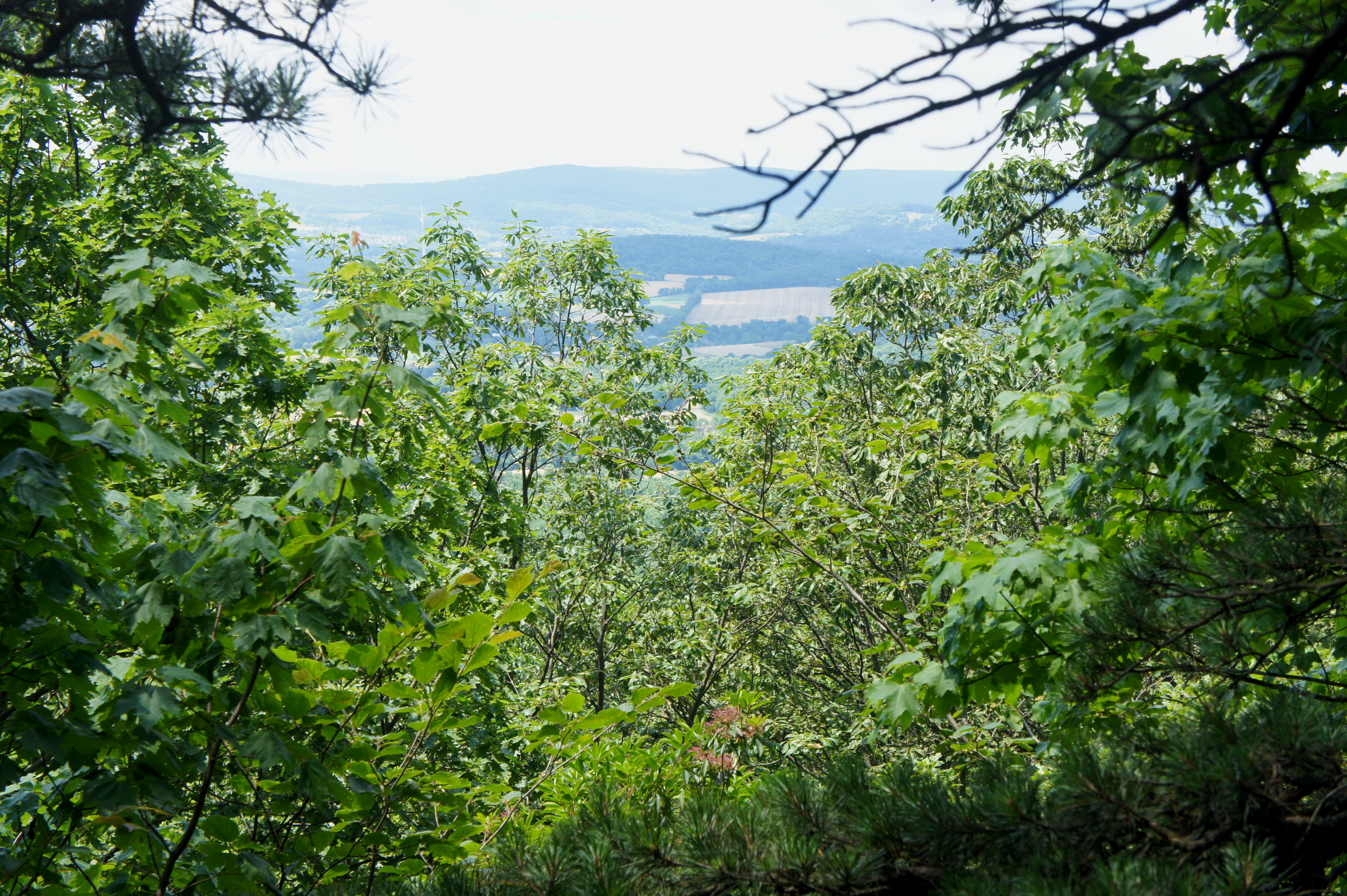
Not until 5.5 miles does the trail split again; this time, the Black Locust Trail enters from the left, merging with Yellow Poplar for the next ½ mile. With the road tantalizingly close on the left, the trail instead bears right, sheds around 100 feet in elevation, and approaches a spur trail leading to a “scenic view.” Turn right on the spur, following the well-trodden path under dense canopy to the overlook: a singular rock perched along the west-facing hillside. The spot provides an obscured and underwhelming view of the valley—but nonetheless the best that Yellow Poplar has to offer. (Note: Better views can be had at North and South Frederick Overlooks situated off Gambrill Park Road.)
After stopping at the viewpoint, continue south down the spur trail, which reconnects with the main path after 100 yards. Around the 6-mile mark, hikers will reach a junction that is within earshot of the starting place—and bearing left at the fork will return you to the nature center and parking area. But those determined to finish the entire loop should hang a hard right, where the Yellow Poplar Trail separates from Black Locust and continues southward around the southern cone of High Knob. The trail gradually descends as it bounds east and reaches a 4-way junction at 6.6 miles. Stay straight on the multi-blazed trail—Yellow Poplar, Black Locust, Green Ash, and Red Maple all share the same path.

From here, the trail climbs for 1/10 mile to meet Gambrill Park Road once again. Cross the street to the parking area on the east side, then look for the continuation of Yellow Poplar at the end of the parking lot to the left. Beyond, the trail makes up for lost elevation in a final, 150-foot climb back to the trailhead, roughly following the omnipresent power lines until the trail ends, at last, where it began: at the road junction just north of High Knob Nature Center.
While not overly strenuous, this 7.1-mile jaunt feels like a full day’s hike. Allot at least 3.5 hours, or 4-5 to be safe.
