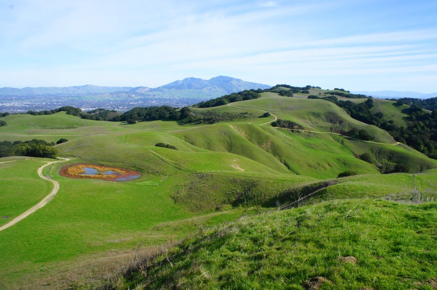
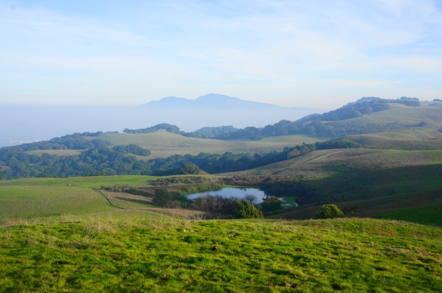
Top 10 Hikes in 2022

Medicine Bow Peak Trail, Medicine Bow National Forest, July 2022

As 2022 draws to an end, it is—as per tradition—time to look back on the year at Live and Let Hike. This is the ninth year of the blog—the tenth anniversary coming in 2023—and there was no let-up in content, as I published 68 entries, the most since 2017. Viewership remained strong, clocking in more than 276,000 page views (185,000 visitors), the second-highest year on record (a milestone of 1 million total visitors is approaching next year!).

As usual, my trail descriptions spanned many different states, with a majority coming from a lengthy road trip to and from Michigan in June and July. Highlights along the way included a 2-day trip to Colorado/Utah’s Dinosaur National Monument, as well as some exploration of parks in the Great Lakes region, including Starved Rock State Park and Indiana Dunes National Park. The return trip included hikes in seven states (WI, MN, SD, NE, WY, ID, and CA), ranging from the hilly Driftless Area of the Upper Midwest to the bluffs and waterfalls of northwest Nebraska to the Snowy Range of southern Wyoming and Idaho’s City of Rocks. Aside from this major journey, I also managed two trips to southern Arizona—one in January and one in November—where I explored hikes at Coronado National Monument, Chiricahua National Monument, Organ Pipe Cactus National Monument, Saguaro National Park, and other sites in the Phoenix and Tucson areas. In March, Spring Break with my parents brought us to California’s Monterey/Big Sur area and Pinnacles National Park. In May, I took a short camping trip with friends to the Wawona area of Yosemite National Park, and I tackled a portion of the challenging Lost Coast Trail in Sinkyone Wilderness State Park on a 3-day out-and-back—the only overnight backpacking of the year. The rest of the year was relatively quiet, focusing on work or local Bay Area hikes. Expect the backlog from this year’s hikes—especially the November Arizona trip—to trickle in by early 2023…in addition to whatever the coming year’s adventures bring.

The top five most visited posts on Live and Let Hike in 2022 were, interestingly, all from hikes completed in 2021: (1) The New Wave Loop (Glen Canyon National Recreation Area, AZ); (2) Scorpion Canyon Loop Trail (Channel Islands National Park, CA); (3) Buckskin Gulch via Wire Pass (Paria Canyon – Vermilion Cliffs Wilderness, UT); (4) Cavern Point – Potato Harbor Loop (Channel Islands National Park, CA); and (5) John Muir Trail Northbound Section 4 – Red’s Meadow to Happy Isles (Ansel Adams Wilderness & Yosemite National Park, CA). The top eye-catchers from this year, however, were: (1) Flatiron via Siphon Draw Trail (Superstition Wilderness, AZ); (2) Lower Mariposa Grove Loop (Yosemite National Park, CA); (3) Chilnualna Falls Trail (Yosemite National Park, CA); (4) Pfeiffer Falls Trail (Pfeiffer Big Sur State Park, CA); and (5) St. Louis Canyon and Aurora Canyon (Starved Rock State Park, IL).

In keeping with tradition from past years, see below for a list of my top ten favorite hikes of the year:

10. Jones Hole Trail & Ely Creek Falls (Dinosaur National Monument, UT)

Boasting canyons and high cliff walls that rival southern Utah, Dinosaur National Monument along the Colorado/Utah border has limited but exceptional hiking opportunities, including the gentle Jones Hole Trail. This nearly 8-mile out-and-back follows a perennial stream and includes spurs to ancient petroglyphs and a pretty waterfall before culminating at the banks of the roaring Green River.

See my post on July 3, 2022 for a full trail description.

Jones Hole Trail, Dinosaur National Monument, June 2022

9. Flatiron via Siphon Draw Trail (Superstition Wilderness, AZ)

Arizona’s Superstition Mountains rise sharply from the suburbs of Phoenix, seemingly forbidding and impossible to surmount—but a narrow draw outside Lost Dutchman State Park leads hikers up to the summit of Flatiron, a prominent peak with expansive views. Expect a workout—and even a brief, Class 3 climb—on this challenging but immensely popular hike, a local favorite.

See my post on March 20, 2022 for a full trail description.

Flatiron, Superstition Wilderness, January 2022

8. Juniper Canyon Trail to High Peaks Loop (Pinnacles National Park, CA)

Partly a repeat of a hike that made the top 10 in 2019, this scenic stem-and-loop instead takes off from the west side of California’s Pinnacles National Park, climbing Juniper Canyon to the cliffy High Peaks area. Expect wild staircases and narrow passages as hikers wind through the rhyolite, hoping to catch glimpses of the park’s famed California condors.

See my post on May 24, 2022 for a full trail description.

Juniper Canyon Trail, Pinnacles National Monument, March 2022

7. Mitten Park Trail (Dinosaur National Monument, CO)

This remote and rarely-used trail on the Colorado side of Dinosaur National Monument follows the Green River from Echo Park to nearby Mitten Park, situated along a dramatic fault line that produced wildly-shaped formations. This rugged 3-mile out-and-back has some strenuous climbs but offers likely solitude in one of Colorado’s most beautiful canyons.

See my post on July 23, 2022 for a full trail description.

Mitten Park Trail, Dinosaur National Monument, June 2022

6. Chilnualna Falls Trail (Yosemite National Park, CA)

In Yosemite National Park, a land known for dramatic waterfalls, Chilnualna Falls is one of the tallest—and much less-visited than those dotting Yosemite Valley. Situated in southern Yosemite, the Chilnualna Falls Trail climbs more than 2,000 feet to a multi-tiered waterfall, with additional views of Wawona Dome and the woody Wawona Valley.

See my post on June 2, 2022 for a full trail description.

Chilnualna Falls Trail, Yosemite National Park, May 2022

5. St. Louis Canyon to Illinois Canyon (Starved Rock State Park, IL)

A gem in heart of the Great Plains, Starved Rock State Park in northern Illinois features more than a dozen sandstone canyons, towering waterfalls, and an extensive trail network. Hikers seeking to “do it all” can cover all the major canyons in one long, 14-mile hike, covering four distinct sections: (1) a roughly 1.5-mile one-way trek from St. Louis Canyon to the Visitor Center (including dramatic St. Louis Canyon Falls); (2) a 4.5-mile circuit that includes French, Wildcat, and LaSalle Canyons and a clutch of additional waterfalls; (3) a somewhat dull connector by way of Owl and Hennepin Canyons; and (4) an incredible trio of canyons—Ottawa, Kaskaskia, and Illinois—at the eastern end of the park.

See my collection of four posts from August 2022 for full trail descriptions.

Ottawa Canyon, Starved Rock State Park, June 2022

4. Chiricahua Big Loop (Chiricahua National Monument, AZ)

This all-day hike explores the wonderland of rhyolite pinnacles found in southern Arizona’s Chiricahua National Monument, climbing in and out of canyons and through basins of stone. Many settle for just a portion of the so-called “Big Loop,” but the entirety of the 9-mile trek is well worth the effort.

See my post forthcoming in the coming weeks!

Heart of Rocks Loop, Chiricahua National Monument, November 2022

3. Point Lobos Loop (Point Lobos State Natural Reserve, CA)

The popular but incredibly scenic Point Lobos is all about rugged, oceanside landscapes and dramatic colors, including the turquoise waters of China Cove, orange creamsicle-colored slots of the Weston Beach area, and high clifftop views of Sea Lion Cove and the Cypress Grove Loop. Also expect to see seals, sea lions, and other fauna along the shores of the Pacific Ocean, in addition to some of the best-preserved stands of Monterey cypress in the world.

See my post on May 20, 2022 for a full trail description.

Point Lobos Loop, Point Lobos State Natural Reserve, March 2022

2. Lost Coast Trail – Needle Rock to Little Jackass Creek via Wheeler Camp (Sinkyone Wilderness State Park, CA)

Covering a wild and overgrown section of the fabled Lost Coast Trail, this strenuous backpack traverses redwood groves, high cliff passages, and unsullied beaches in northern California’s Sinkyone Wilderness. Start out from the Needle Rock Visitor Center, making your way south to Wheeler Camp and on to the secluded beach of Little Jackass Creek and beyond.

See my posts on June 4, 2022—Part I and Part II—for a full trail description.

Lost Coast Trail, Sinkyone Wilderness State Park, May 2022

1. Medicine Bow Peak Loop, including Lakes Trail (Medicine Bow National Forest, WY)

The best hike of 2022 was a strenuous, 7-mile circuit in the Snowy Range of southern Wyoming, rising to the summit of Medicine Bow Peak (12,013’) before skirting a series of stunning subalpine lakes. Enjoy the panoramic views and dramatic vistas along what is one of the premiere day hikes in all of Wyoming and was certainly the best of my summer road trip.

See my post on December 28, 2022 for a full trail description.

Medicine Bow Peak, Medicine Bow National Forest, July 2022

Honorable Mention:

Posted in Arizona, Big Sur, California, Colorado, Dinosaur National Monument, Illinois, Moderate Hikes, Pinnacles National Park, Sinkyone Wilderness State Park, Starved Rock State Park, Strenuous Hikes, Utah, Wyoming, Yosemite National Park | Tagged , , , , , , , , , , , , , , , , , , , , , , , , , , , , , , , , , , , , , | 1 Comment

Fossil Butte National Monument, WY

Fossil Butte National Monument, July 2022

Visitors to southwest Wyoming’s Fossil Butte National Monument, when they get out of their cars at the Visitor Center, are treated to a walk back in time: interpretive signs and markers along the deck and sidewalk point out different geological epochs and the creatures that inhabited the Earth at the time. Eventually, as the path approaches the Visitor Center, one reaches the early Cenozoic Era—after the dinosaurs went extinct 65 million years ago—and the time period from which the area’s famed plant and animal fossils derived.

Today, the landscape at Fossil Butte resembles a semi-arid desert, with few tall trees amid the scrubby and windswept terrain. But this was once part of the vast 1,500-square mile “Fossil Lake,” which gave life to a variety of species. Quarrying in the area, which ran from the late 19th century to today produced a bonanza of spectacularly-preserved fossils, some of which are on display in the Visitor Center today.

In addition to viewing the fossils, visitors to Fossil Butte National Monument can hike to the historic quarry—which unfortunately has no fossils to view—and/or complete the 5.5-mile one-way Scenic Drive. The latter climbs sharply to a high plateau overlooking the park and the many canyons of the surrounding area. The national monument makes for a pleasant ½-day visit, situated just off U.S. Route 30 between Kemmerer, Wyoming and Bear Lake, Utah. See below for a selection of photos from a trip to the park.

Fossilized turtles at the Visitor Center
Fish fossils
Fossilized palm at the Visitor Center
Ancient crocodile specimen
Morning at the Historic Quarry
Fish cross-section: the closest thing to a fossil found on the Historic Quarry Trail
Following a bench along the Historic Quarry Trail
The tiny A-frame of early 20th century fossil digger David Haddenham,
who earned a living selling fossils found in the quarry
Dusk approaching over Fossil Butte
Male pronghorn
Bigger group of pronghorn
Sun setting outside Fossil Butte National Monument
Posted in Wyoming | Tagged , , , , , | Leave a comment

Medicine Bow Peak Loop, including Lakes Trail (Medicine Bow National Forest, WY)

Medicine Bow Peak Trail, Medicine Bow National Forest, July 2022

At 12,013 feet, Medicine Bow Peak is the highest mountain in southern Wyoming’s Snowy Range, a small but exceptionally scenic slice of the broader Medicine Bow Mountains, which extend into northern Colorado. The peak is accessible via a relatively straightforward climb, with some decent elevation gain but no scrambling or technical climbing, making this a popular favorite of residents in nearby Laramie or Cheyenne, Wyoming. In addition to 360-panoramic views from the summit, the Medicine Bow Peak Loop passes through spectacular meadows and skirts glimmering alpine lakes, making this roughly 7-mile day hike easily one of the most memorable jaunts in southern Wyoming and beyond.

Map of Medicine Bow Peak Loop, Medicine Bow National Forest; created using alltrails.com

The hike

The downside of relative proximity to Laramie and other prominent towns is that the Snowy Range is often overrun with visitors, with the vast majority concentrated in the handful of square miles surrounding Medicine Bow Peak. Campers, anglers, hikers, and bikers easily fill in the campgrounds and picnic areas around Mirror Lake, just west of Snowy Range Pass (10,847’) and the highest point on the 29-mile Snowy Range Scenic Byway. Plan to arrive early in the day to secure a parking spot at one of the multiple trailheads, a strategy that also helps to avoid the late afternoon thunderstorms that frequent the area in summertime.

There are several options for accessing the 6.9-mile Medicine Bow Peak Loop, which combines the Medicine Bow Peak and Lakes Trails. One is to start at popular Mirror Lake, although the parking is very limited; the other—and preferred—option is to begin and end at the West Lake Marie Trailhead, located just over a half-mile south of Mirror Lake. Here there is parking for perhaps a couple dozen vehicles, with late-comers tending to park along the shoulder in both directions.

Start of Medicine Bow Peak Trail from West Lake Marie Trailhead

West Marie Lakes Trailhead to summit via Medicine Bow Peak Trail (3.6 miles)

Three distinct trails take off from this starting point: the Lakes Trail, the Lake Marie Falls Trail, and the Medicine Bow Peak Trail. The latter begins by climbing a modest staircase through a clutch of lifeless pines, seemingly marred by weather or beetles. However, the verdant meadow, teeming with wildflowers and beaming with color, more than makes up for the struggling forest. One can also begin to make out the range of precipitous mountains ahead, beginning with The Diamond (11,720’), then Old Main (11,755’), and—in the distance—Medicine Bow Peak (12,013’). The Medicine Bow Peak Trail will eventually tuck behind these peaks to the west and north before summitting Medicine Bow.

Wildflowers in the meadow south of Lake Marie

After around 75 yards, the trail splits, with a spur heading right to a shelter and picnic area overlooking Lake Marie. The main track bears left, beginning a steady alpine climb. Soon the Medicine Bow Peak Trail treads uphill and southward, away from the lakes and peaks before rounding a right-hand switchback that carries hikers up a pine-studded ridge.

Switchbacks on Medicine Bow Peak Trail

The open moraine gives way to terrific views across Lake Marie to Mirror Lake and Sugarloaf Mountain (11,398’). While the rest of the surrounding Medicine Bow Mountains resembles a lower, forested, and mild-sloping plateau, the Snowy Range rises precipitously—a case of a mountain range on top of a mountain range. The peaks, affectionately known as “The Snowys,” are composed primarily of quartzite, evidence of ancient sand deposits that were thrusted upward with the Rocky Mountains; centuries of erosion then left behind the jagged and magnificent mountains seen today.

Remarkable view of Lake Marie, with Medicine Bow Peak, Sugarloaf Mountain, Lookout Lake, and Mirror Lake in the distance

As the hike continues, the distant summit of Medicine Bow Peak becomes obscured behind The Diamond and Old Main, but the vista now extends as far as Lookout Lake, which will be encountered later in the hike. At around ½ mile, the trail begins edging away from the peaks again, treading south and west to an open slope with westward views. Hikers can see a higher ridgeline ahead.

Terrific views of the highest peaks in the Snowy Range

Minutes later, the Medicine Bow Peak Trail starts moving north again toward the three summits along a relentless uphill. After a welcome patch of spruce trees that provide rare shade on the largely exposed hike, the onward route begins the toughest climb of the entire loop.

Climb through two patches of boulder rubble, enjoying expansive views between huffs and puffs. The large mountain range in the distance—to the southwest—is the Sierra Madre, another snow-capped range, positioned on the Continental Divide, that extends into northern Colorado.

Mandatory pika shot
Westward views toward the Sierra Madre

The uphill boulder slide section—the scree more of a nuisance than an obstacle—is interrupted briefly by an ease in the incline. But the climb continues again as the trail wraps around to the west flank of the mountain range. At 9/10 mile—still in the rock scree—tackle a right-hand switchback, bearing east again. After a brief time away, the path returns to a spot overlooking the lakes to the east, now with a bird’s eye view down to Mirror Lake and Lake Marie.

Look down at Lake Marie and Mirror Lake

Take a left-hand switchback, then traverse an open and very steep incline that lasts perhaps 1/10 mile before finally easing. Follow the trail—marked with wooden stakes—as it offers its first views northwest, toward Pennock Mountain (10,043’) and an extension of the Medicine Bow Mountains. Hikers also get a look at the terrain ahead—still dotted with quartzite but much milder and flatter than the previous half-mile.

View around to the west side of the mountains

Thus begins a long, easy section with unobscured views westward toward Saratoga and the Sierra Madre. Mild ups and downs are interrupted briefly by a longer climb at around 1.6 miles, but this too gives way soon enough to easier tread. At 1.8 miles, the route passes a gap between two peaks on the right: this is the modest division between The Diamond and Old Main, both of which are not summited on the trail.

Traversing the tundra leads to a minor crest and another open basin walk with the first views of Medicine Bow Peak since the start of the hike. Here the peak appears imposing but much less difficult than before.

View down to Dipper Lake and Turpin Reservoir, with Pennock Mountain in the distance

At 2.25 miles, approach a sign for the “Old Lookout Cabin,” where a spur leads to the namesake, situated in the gap between Old Main and Medicine Bow Peak. A rise to the saddle offers more eastward views, and a smattering of subalpine lakes to the west are also now visible, including Dipper Lake and Turpin Reservoir. Pass a sign at 2.4 miles for “Medicine Bow Peak,” then—after mounting a boulder pile—the trail actually descends for a brief period. A nice grassy section skirts scree fields on the right.

Trail junction, below the summit, at the start of the final climb

Upon approaching a trail junction at 2.8 miles, the 1.5-mile level section comes to an end. The Dipper Lake Trail bears left for 1.7 miles, ending at its namesake, but the Medicine Bow Peak Trail continues right, immediately beginning an intense uphill.

Encompassing westward view

The demanding climb is made more difficult by the altitude, as hikers have now crested 11,500 feet. Some level stretches at 3.1 and 3.3 miles offer some respite, but overall, the path ascends relentlessly, in a final push for the summit of Medicine Bow Peak. As with many peak-bagging hikes, there are false summits, one of which is passed on the right at around 3.3 miles. Here visitors can see the true summit ahead, however, with less than 100 feet in elevation gain to go.

Approaching the final climb to the summit

Come to the base of the summit hump, with views from the ridge looking down more than 1,000 feet to the lakes below. The final ascent is the hike’s closest analogue to a true rock scramble, with hikers having to contend with loose and bulky quartzite rocks. But the trail is evident and ascent mild, culminating at the 12,013-foot summit.

At the summit of Medicine Bow Peak!
Views from the summit – to Old Main, Lookout Lake, Mirror Lake, and Lake Marie

The views from Medicine Bow Peak, as expected, are simply splendid. In addition to the westward views, hikers can now look south to the parade of alpine lakes—Lookout, Mirror, and Lake Marie—guarded on the right by the near-vertical cliffs of The Diamond and Old Main. One can also see east to a clutch of other lakes, including Lewis, Libby, and Klondyke Lakes. Eventually the Snowy Range fades away, with the Laramie Valley beyond.

View east to Klondyke Lakes, Lewis Lake, and Libby Lake, with Laramie Valley in the distance
Another south-facing view as a weather system comes in

Space is at a premium at the summit, which can get crowded on summer weekends, but there are enough spots to sit and enjoy the views over lunch or a snack. Better yet, at 3.6 miles, the hike is only around half-way complete, with more scenic terrain ahead to complete the loop.

Summit to West Marie Lake Trailhead via Lakes Trail (3.3 miles)

Here at the summit, loop trekkers will mix with day hikers who opted to take on the summit as an out-and-back from the Lewis Lake Trailhead—a shorter but less rewarding walk. The two groups will combine for the next section, a long and steady descent to a low saddle between Medicine Bow and Sugarloaf Mountain.

The main lakes complex from the descent

The descent begins by heading straight down an east-west ridge, then four switchbacks and a straightaway that can be snow-covered through much of the year. Follow signs and the scores of hikers bounding down stairstep switches, with near-constant views of the lakes to the east and south. For a while, the shade-less tread heads south toward Lookout Lake and the rest of the massif, but soon the wiggles extend back and forth, with careful footing required on the rocky and often slippery surface. (Note: On the summer afternoon in July when I did this hike, it started hailing around this point.)

Descending to the low gap
Dozens of lakes to the east, including South Gap, Klondyke, Lewis, Libby, Telephone, and Brooklyn Lakes

At last, almost a mile from the summit, the trail reaches the saddle and junction with the Lakes Trail. With the out-and-back hikers heading left to Lewis Lake, the crowds thin again along the Lakes Trail, another beautiful section of this star-studded hike.

First pools along the Lakes Trail as the weather clears

After traversing an alpine meadow, the path briefly cuts through a stunted conifer section, then passes the first of several small, unnamed pools on the right. From here the mild track weaves within reach of a second, smaller pond, then skirts a low ridgeline on the left. Pass a small boulder field, then a third pool, at around 4.9 miles. All the while, the towering façade of Old Main dominates the landscape.

More small ponds in the alpine area as it transitions to moraine
Beautiful moraine with small unnamed lakes
Looking back at Medicine Bow Peak

From here the Lakes Trail rises slightly to a beautiful moraine with wildflowers and patches of pines. Pass through a gap, descending next to Lookout Lake—the largest lake encountered on the hike—which is surrounded by pines on the east bank but flanked by scree and rubble on the west side.

Lookout Lake

A very steep downhill at 5.3 miles leads to a curious, unmarked junction. Bear left, with the path moving southward in the direction of the Mirror Lake and Lake Marie Trailheads. With Lookout Lake still down to the right, cross over a small stream, then climb a mild slope with open views as the lake thins to a narrow channel. (Note: In dry years, this narrower strip is actually a separate lake.)

Looking back at Lookout Lake and Medicine Bow Peak
Following Lookout Lake as it narrows

Soon the path settles into a downhill wooded section, then an up and down in the open with the lake reaching its terminus on the right. It is a short walk from here to the Mirror Lake Picnic Area, where there is limited trailhead parking.

Mirror Lake – a popular picnicking spot

At the first sight of the road, take a left, finding your way out of the parking area and to the shores of Mirror Lake. With the lake on the left, continue along the entry road until a wide and marked path bears right. (Note: There is a sign here that reads “No Parking – Trail to Marie Lake.”) The paved route is a pleasant stroll that first skirts an inlet of Lake Marie before coming to another small parking area.

Skirting the inlet at Lake Marie

Stay on the path as its parallels the road, with the rest of Lake Marie now coming back into view. A sign indicates that hikers have entered Carbon County. With the parking area now in sight, the trail crosses a final bridge; turn left and return to the trailhead, ending the 6.9-mile loop hike.

Reflections of the Snowys in Lake Marie
The Diamond above Lake Marie

Although one of the easier 12,000-foot summits in Wyoming to reach, this hike is considered strenuous due to its length, considerable elevation gain, and high altitude conditions. Hikers should expect to take at least 4-6 hours to complete the loop.

Final look at Lake Marie
Posted in Strenuous Hikes, Wyoming | Tagged , , , , , , , , , , , , , | 3 Comments

Mexican Canyon Trail Loop, inc. Scenic View Trail (Fort Robinson State Park, NE)

East Mexican Canyon Trail, Fort Robinson State Park, July 2022

Fort Robinson, a former U.S. Army base dating to the late 19th century, may be the most popular destination in the state park that bears its name—but the natural highlights lie beyond to the north and west in the sedimentary rock canyons and high bluffs that form part of northwest Nebraska’s Pine Ridge. This 22,000-acre state park features an extensive—if underdeveloped—trail network for hiking, biking, and horseback riding, and the Mexican Canyon Trail Loop covers some of the most spectacular terrain. Expect on this 3.2-mile journey to see towering chalk cliffs, photogenic box canyons, and a diversity of flora and fauna.

Map of Mexican Canyon Trail Loop, Fort Robinson State Park; created using alltrails.com

The hike

To reach the trailhead, head northwest on Soldier Creek Road from Fort Robinson, bearing in the direction of remote Soldier Creek Wilderness. Here the road traverses a broad plain that bisects the state park, with the main complex of buttes, ridges, and plateaus dominating the skyline to the north. Drive on Soldier Creek Road for 1.6 miles, bearing right at the sign indicating the Mexican Canyon Trailhead. A dirt, steep doubletrack—likely accessible with any vehicle unless conditions are wet and muddy—leads uphill to a mound south of the cliff-line with early views.

Looking back at the trailhead from the Mexican Canyon Trail

At the trailhead, there is a small white picket fence enclosure, as well as a picnic table and information on the resident bighorn sheep—which you have a decent chance of seeing on the hike. The loop hike described combines the Mexican Canyon Trail, East Mexican Canyon Trail, and a ¾-mile spur to the park boundary on the Scenic View Trail, heading in a clockwise direction.

Mexican Canyon and the chalky cliffs from the Mexican Canyon Trailhead

Begin the hike by finding the grassy doubletrack path heading up the ridge to the northwest, quickly putting the small trailhead in the rear-view mirror. Views of the crumbly cliffs are immediate—although they improve significantly as the journey continues. Between the Mexican Canyon Trail and the bluffs lies Mexican Canyon, one of the longest incisions in the park’s highlands. The usually dry canyon nonetheless bears significant life, including a diversity of conifers characteristic of the broader Pine Ridge.

View of the cliffs from near the Mexican Canyon Trailhead
Looking down into Mexican Canyon

The Mexican Canyon Trail keeps its distance from the bluffs visible to the north, but another high ridge begins to take shape on the left—this is the long arm of Walter Reed Butte (4,401’), named for the Army doctor who also became the namesake for the famous veterans’ hospital in Washington, DC. (Note: The trail never quite summits the butte but comes close.)

View down Mexican Canyon

At about 0.35 miles, the trail splits—marked by white stakes—with an incredibly steep slope heading left. Given the two forks meet up again soon, it is best to go right, where the tread is easier and incline more gradual. There is a short steep section, but soon the trail levels again, and the two alternatives weave back together.

It is not long until the stiff climb returns, with hikers now getting a workout as they continue to skirt the fringes of Walter Reed Butte. The trail approaches some small chalk outcrops on the left, and there are excellent views down-canyon to the south and east. Upon cresting a moderately high saddle, hikers are greeted with a junction: the intersection of the Mexican Canyon Trail—which continues northwest—and the East Mexican Canyon Trail, a more scenic alternative. Head right, beginning a pleasant downhill section.

Immediately after turning right, there is a short spur to an outcrop with canyon views, with the main track gradually dropping left down a windy ridgeline. More or less follow the white stakes as the singletrack skirts tall grasses and yucca plants, with distant views of the trail network snaking below the stony cliffs to the east.

Starting the descent into Mexican Canyon

Eventually the trail starts to descend more steeply into Mexican Canyon, a shady gulch that feels a world away from the open desert pitches above. Here the landscape is teeming with shrubs and tall pine trees, with water running seasonally through the channel.

Down in the cool, shady cover of Mexican Canyon

Hikers’ time in the canyon, however, is abbreviated, as the trail quickly climbs out again to the left (see the white trail marker), by way of an incredibly steep pitch that should be taken with care. This brutal but brief uphill brings hikers back up into the open prairie, with continued views.

Here the faded grassy path becomes harder to follow, but white stakes generally lead the way, and the path becomes more visible as it climbs the ridgeline. Soon, at 1.4 miles, the trail reaches a much better-defined intersection, with wide and well-worn paths heading left and right. The views from the junction are excellent, with up-close vistas of the cliff-line and grand panoramas down to the Soldier Creek Basin and Fort Robinson area.

Bluffs and junction straight ahead

While the loop continues right (east), it is hard to resist taking the spur path left on the Scenic View Trail, a ¾-mile out-and-back that ends at the northern park boundary. Hikers in a hurry can skip this, but those with more flexibility are rewarded with an interesting detour that tucks behind the upright buttes and traverses high ridges.

Grand panorama of the bluffs along East Mexican Canyon Trail
View eastward to the darker cliffs

The out-and-back begins by cutting left, following the sandy doubletrack up and around a protruding outcrop. Rounding north and east, the Scenic View Trail rises to a gap with views south across the rolling plain, with a peculiar thumb-shaped hoodoo ahead.

Approaching the thumb hoodoo on the Scenic View Trail

Minutes later, the trail comes to a second gap, with views east to a series of dark-colored buttes. The onward path then keeps the thumb on the right and bounds toward the park boundary, edging a hillside with occasional pines and plenty of high grasses and flowers. Eventually the trail fades significantly, but a thin trace continues through the lawn.

Along the Scenic View Trail, with the park boundary within reach
Views east from the second gap

The spur ends perhaps unceremoniously with a steep climb to a closed gate, with private property beyond. This is the northern boundary of Fort Robinson State Park. There are nice views back south, however, and up-close views of the conglomerate cliffside, with dark stones cemented into the peachy rock.

View from the park boundary at the end of the Scenic View Trail
Westward vista

When ready, return the way you came, returning to the East Mexican Canyon Trail. Bear left on the wide track, which follows a shelf below the striated cliffs and rounds a left-hand bend with fine views. Upon clearing the next major drainage, the trail passes below a row of towering sentinels—the same impressive cliff faces visible from near the trail’s start around 2.25 miles back.

Impressive side canyon along the East Mexican Canyon Trail

Beyond, the track rounds a series of wiggles, skirting minor side ravines, eventually coming to a junction with the Deer Trail at 2.4 miles. Stay right on the East Mexican Canyon Trail, descending a ridgeline with a double-lane dirt track. The incline soon weakens, and the trail traverses an open grassland. The chalky knobs and buttes are now far in the rear-view mirror, and the end of the hike is near.

Descent back toward the trailhead

At 2.8 miles, come to a junction and stay right, returning to the (West) Mexican Canyon Trail, which continues south for another 200-250 yards. Pay close attention for an unmarked four-way junction, where hikers should take a hard right. Traverse a woody drainage with small, mucky pool on the right, then take a final left at the last junction. From here the trail rises a modest slope and returns to the white-fence enclosure and trailhead. This marks the end of the 3.2-mile stem-and-loop hike.

East Mexican Canyon Trail running down toward the Soldier Creek valley
Posted in Moderate Hikes, Nebraska | Tagged , , , , , , , , , | 1 Comment

Blackhills Overlook Trail Loop (Chadron State Park, NE)

Blackhills Overlook Trail, Chadron State Park, July 2022

Rising suddenly and surprisingly, the scenic Pine Ridge cuts like a furrowed eyebrow across northwest Nebraska, revealing an elevated landscape of thick ponderosa forests and chalk canyons. The 100-mile ridge is a sudden break from the flats of the Great Plains and bears some of the best hiking in the Cornhusker State. Situated at roughly the ridge’s halfway point (west-to-east), Chadron State Park is a popular destination off U.S. Route 385 between Chadron and Alliance, Nebraska, and the park’s best hike is the Blackhills Overlook Trail, a moderately-difficult 4.7-mile adventure. Along the trail, hikers will traverse tallgrass prairies and ponderosa woodlands and rise to heights above the Niobrara chalk bluffs that dominate the landscape. (Note: Be sure to wear long pants on this hike, as ticks are a major problem in this area.)

Map of Blackhills Overlook Trail, Chadron State Park; created using alltrails.com

The hike

To reach the trailhead, enter Chadron State Park (entrance fee required) off Highway 385 and make your way north to the park campground. Round the one-way loop through the camping area until passing sites #47 and #49 on left and right; thereafter, pass the non-reservation tent camping area on the right and park at a small and unmarked pull-off just before the road heads back east. (Note: If you pass Sites #50 and #51, you have gone too far.) The unassuming trailhead lies on a crest just above a typically dry tributary of Chadron Creek and the pleasant tent camping area, set at the edge of a ponderosa pine stand.

The Blackhills Overlook Trail is a bit of a misnomer: while there are very distant views of the Black Hills in neighboring South Dakota, the predominant vistas are of Pine Ridge, a curious feature punctuated by chalky bluffs and deep canyons. (Note: There are multiple options for loops on this hike, but the below description follows the recommended route in the “Northwest Nebraska Recreational Trails Guide.”)

At this stage, the towering bluffs are not yet visible, and the unmarked but evident trail traverses a grassy upland. Soon a barely helpful sign emerges—it says merely “start trail”—and the route cuts through prairie before dropping into the ravine, keeping the tent area on the right. Pass through a rarely-used campsite and then through an open gate, immediately reaching a four-way junction set at the edge of the pine forest. Stay straight, following the path as it eventually bears westward, following what feels like a long trench on a double track that was likely an old ranching or logging road.

After about ¼ mile, still in the shaded gully, pass through another gate and enter a “special hunting area” (October-December), followed soon by the abrupt exit out of the ravine, entering open prairie. At 4/10 mile, there are finally some more robust trail signs (but even these are not incredibly helpful; be sure to carry a map with you): while the quickest route to Blackhills Overlook is to head left, the more scenic route heads right. Take the right fork to enjoy the alluring ascent to the sandstone bluffs.

Looking back at a chalky ridge along the Blackhills Overlook Trail

These bluffs finally come into view soon after the junction, as the doubletrack quickly fades into a single lane and the route parallels a minor drainage on the right. The exquisite cliff faces gleam in the morning and evening sun, and the valley begins to resemble more of a canyon as the trail continues. At 0.55 miles, the incline picks up, and the path cuts away from the drainage. Tree cover gradually fades away, and the route levels off as it approaches a beautiful amphitheater of rock with several chalk outcrops. Pass a bench on the right and then drop to clear the drainage again, rising again to an open pitch with a solitary pillar on the right.

Heading uphill toward the high saddle

Ascend gently through a sun-soaked section, coming closer to a high saddle. After passing through a cattle guard at 8/10 mile, the Blackhills Overlook Trail briefly leaves the confines of the park. Soon the onward route comes to the pass, revealing additional vistas beyond: north and east to additional bluff structures along Pine Ridge and—on the very, very distant horizon—the Black Hills of South Dakota.

Northward views along the onward trail beyond the saddle

After cresting the saddle, hikers are greeted with some ever-elusive trail signs. The route heading right leads to the Outrider Trailhead, an alternative approach to the overlook loop that starts just north of the state park. Heading left continues to Blackhawk Overlook. Looking out across Crawford Valley, follow the narrow singletrack left as it skirts the hillside. A steep uphill comes abruptly at the one-mile mark, and the path ascends to the wind-swept ridgetop, passing occasionally desert yuccas.

Up-and-down trail along the ridgeline

Climb to a point that offers a look both north and south, with lots of dead wood from a recent fire, then start a roller-coaster section that dips up and down along the ridgeline. The landscapes on the left get better and better, as hikers pass narrow and deep-carved canyons. The vistas to the north are grand and wide, with views out to prominent Flannigan Butte (4,236’). Here the trail also reenters Chadron State Park.

View into dramatic canyon
Fire-stricken section

At 1.3 miles, the trail forks again. Continue right toward Blackhills Overlook, continuing to follow the ridgeline on a mostly level tread. This splendid section is easily better than the overlook itself, with tree cover at a minimum.

Chalky buttes just outside Chadron State Park
Evening sun in the direction of Flannigan Butte

Soon the pines do come back, and the westward trail leaves the park again at 1.5 miles, passing through a gate and cattle guard. The official Blackhills Overlook can be found at 1.8 miles, a little over 1/10 mile from the dirt parking area at the end of a long road. After taking in the overlook, follow the path southward to the parking lot—relatively under-utilized but accessible by car. By now hikers have travelled just under two miles from the Chadron SP Campground.

Alas, the rest of the loop is not quite as scenic as the first half, with the next leg requiring hikers to follow a well-graded dirt road for nearly 1.5 miles. The road starts by cutting through a clutch of pines, then reaches an open plateau with the hike’s first views westward to more of the conifer-clad Pine Ridge.

Views north to Crawford Valley from the road

After a left-hand bend at 3.1 miles, the trail approaches the park boundary again—and the official exit route for the hike. There is no gate at the boundary at 3.25 miles, but there is one steps later. Just before it, look for a marked path heading left, paralleling a modest fence. Take this trail, which starts as a grassy doubletrack. At 3.35 miles, the route appears to split, with a well-trodden path heading left, but the correct route bears right, close to the fence.

Soon the path drops into another side ravine, a tributary of the initial one encountered at the start of the hike. But the trail initially stays clear of the bottom, instead staying high above it on the left for a lengthy period. At 3.75 miles, the route splits into three: generally staying left is the best option here, eventually dropping sharply into the main canyon. Once down in the bottom, the route splits again; bear right, heading down the gully northward.

Spooky canyon

The gulch narrows and deciduous cover returns, giving the feeling of a spooky, dark canyon. Briefly reenter the special hunting zone, where the canyon is very narrow and scenic. Finally, at four miles, another path enters from the left, and the main trail heads east, with the valley widening again. About a quarter-mile later, the path climbs briefly up and out of the ravine, returning to the junction encountered near the start of the hike at 4/10 mile.

From here hikers must simply retrace their steps, heading right and dropping down into the initial pine-studded ravine again. After emerging out of the woods, don’t forget to take the trail heading uphill across the prairie to the unmarked trailhead where the 4.7-mile stem-and-loop hike began.

All told, this scenic hike—one of the best in northwest Nebraska—takes about 2-3 hours to complete and is moderately strenuous with some steep sections and some route-finding required.

Posted in Moderate Hikes, Nebraska | Tagged , , , , , , | 1 Comment

Scotts Bluff National Monument, NE

Scotts Bluff National Monument, July 2022

A key milestone along the Oregon and California historic trails, the chalky hightops of Scotts Bluff rise skyward above the broad Platte River Valley in western Nebraska. Here pioneers heading west along the North Platte had to detour south to evade some nasty badlands, bringing them up and over Mitchell Pass, wedged between the impressive towers of Scotts Bluff and South Bluff. Today the area is protected as Scotts Bluff National Monument, a 3,000-acre site that includes a scenic drive, several overlooks, and a small trail system. Panoramic views greet visitors at North and South Overlooks, and ambitious travelers can hike to and from the Visitor Center on the steep Saddle Rock Trail. Scotts Bluff is a must-visit for those passing through the Nebraska panhandle.

Scotts Bluff from near the Visitor Center
South Bluff from the Park Entrance
Driving up the scenic drive to atop Scotts Bluff
View of Saddle Rock from parking area
South Overlook view
Another South Overlook view
North Overlook view
Looking across the town of Scottsbluff
Posted in Nebraska, Uncategorized | Tagged , , , , , | Leave a comment

Daemonelix Trail (Agate Fossil Beds National Monument, NE)

Daemonelix Trail, Agate Fossil Beds National Monument, July 2022

Imagine a creature roughly approximating a beaver or large prairie dog but one that digs holes in a spiral nearly 10 feet deep, forming tunnels resembling a corkscrew or drill bit: this is the curious activity of the prehistoric paleocastor, which lived between 20-30 million years ago in the area now situated in present-day northwest Nebraska. A handful of these “Devil’s Corkscrews”—can be seen up-close on the Daemonelix Trail, one of two hikes in Agate Fossil Beds National Monument. (Note: The other is the 2.8-mile Fossil Hills Trail.) This historic trail also features some of the park’s nicest panoramic vistas, with views across the bluffs and badlands to the Niobrara River Valley and beyond.

The hike

The Daemonelix Trail begins from the first pull-off on the left after entering Agate Fossil Beds National Monument on River Road. The parking lot includes several waysides highlighting nearby attractions in Nebraska, South Dakota, and Wyoming, as well as a map of the one-mile stem-and-loop trail. The easy, pebbled track begins by setting out northward toward the sandstone and limestone bluffs, passing under telephone lines and coming adjacent with a clutch of wavy stones on the right that are remnants of an ancient sand dune.

Start of Daemonelix Trail

Beyond, sunflowers line the trail—which is now composed of mostly red dirt—and the loop section begins at 3/10 mile. Follow the arrow pointing left to tackle the circuit in a clockwise direction. Edging a bluff on the right, the path comes to a wayside and the face of a cliff with the remnants of several Daemonelix, the curiously-crafted burrows of ancient paleocastors.

Wall with remnants of many Daemonelix
Reading about the paleocastor and its burrows

While the burrows from this wall have largely been removed, one can see a preserved corkscrew minutes later: here a clear case about the size of a telephone booth protects a fossilized Daemonelix some 4-5 feet tall. Many of these spirals were excavated by the Carnegie Museum in the late 19th century, years before the discovery of many larger mammal remains at nearby Carnegie Hill and University Hill.

The sandstone wall and encased Daemonelix

From here the Daemonelix Trail climbs and wraps around a left-hand bend, with bluffs on the left and a gulch on the right. Indian ricegrass and yuccas dot the largely arid landscape. After a right-hand turn and the sharpest climb of the hike, the route crests a local summit. From here a panorama unfolds, with views east to Carnegie and University Hills, south to the Niobrara River and Agate Springs Ranch, and north in the direction of Pine Ridge and South Dakota. The overlook from atop this limestone perch is among the best in the park.

Climbing up to the bluffs
View southward from the summit

When ready, continue down the chalky path, soon returning to rosy soil and switchbacking down to a low saddle below two outcrops. Here there is a bench and another encased set of corkscrews, this one a split Daemonelix, leading to two separate nesting chambers. Ancient plant roots and insect burrows can be also be spotted along the exposed sandstone cliffs.

From here the trail courses downhill again, passing the initial bluff on the right and returning to the start of the loop section. By now hikers have travelled about ¾ mile. Bear left here, retreading down the well-worn path, passing the sand dune outcrop on the left and returning to the parking area along River Road. All told, this easy trail with some mild ups and downs clocks in at about one mile, making for a 30-minute-to-an-hour adventure in Agate Fossil Beds.

Posted in Easy Hikes, Nebraska | Tagged , , , , , , , | Leave a comment

Fossil Hills Trail (Agate Fossil Beds National Monument, NE)

Fossil Hills Trail, Agate Fossil Beds National Monument, July 2022

Agate Fossil Beds National Monument in northwest Nebraska was established a mere quarter century ago—in June 1997—but its famed mammal fossils date to the early Paleocene Epoch, just after the mass extinction of dinosaurs 65 million years ago. Dozens of fossil skeletons were discovered in this modest valley, fed by the Niobrara River, in the early 1900s, with some of the most impressive specimens—such as the giant pig Dinohyus and rhino-like Menoceras—displayed in the park visitor center. There is some limited hiking in the park—effectively two trails—and one climbs to the excavation sites at aptly-named Fossil Hills, a pair of high knobs overlooking the Niobrara valley. Although you should not expect to find any ancient skeletons on the hike, there are many interpretive signs—and expansive panoramic views—along the way.

Crude (and somewhat inaccurate) map of the hike

The hike

Agate Fossil Beds National Monument spans an austere valley in northwest Nebraska, south of the coniferous Pine Ridge and north of the Platte River Valley. Commercial amenities are dozens of miles distant in either direction; the nearest locality—known as Agate—is merely a single ranch set in an irrigated basin, at the junction of Route 29 and River Road, just west of the park. The remoteness of the national monument is part of its appeal, though a relatively large Visitor Center offers restrooms, exhibits, and, of course, the fossilized skeletons of several early Cenozoic era mammals.

Carnegie Hill and University Hill from near the Visitor Center

The Fossil Hills Trail, one of two official hikes, begins and ends just outside the Visitor Center. Look for a paved track heading eastward from the building, keeping the parking area and a picnic pavilion on the left and a pair of recreated teepees on the right. Come to the first trail wayside, which offers a map and information on the trail, with a second steps later on invasive plant species. Curiously, just beyond, the Fossil Hills Trail splits, but the two paved tracks come back together in a few dozen yards, forming an oval of sorts through the grassy plain.

Niobrara River from the Fossil Hills Trail

Head east, approaching a set of wetlands below the elevated hillsides to the south. At about 2/10 mile, hikers embark on a boardwalk section that traverses the marshy floodplain of the Niobrara River; this waterway, far wider and mightier downstream, is barely more than trickle at this point, well upstream from the river’s mouth.

Climbing the Fossil Hills Trail

Once across the stream, the Fossil Hills Trail winds southward and begins a mild but steady ascent, climbing up into the prairielands above the Niobrara Valley. The sun-soaked path skirts a minor uplift on the right and comes to a small shelter and bench at ½ mile. Stop here on a hot day for a drink and a breather. Here one can also read about Lieutenant Governeur K. Warren, who explored the area in 1857.

Views back toward Niobrara Valley

Up to the right (southwest), hikers can see the partly-exposed escarpments of University Hill and Carnegie Hill, the two “Fossil Hills” where paleontologists unearthed the specimens of various mammal species. Hikers will soon be atop a ridge between these two hills. But first, a steady climb is in order, with the still-paved track passing a sign for the “Bone Cabin” on the right and reaching a second sun shelter at 0.95 miles.

It is a short walk from here to a right-hand bend, which leads into another ascent, this time a straight shot up to the high saddle between University and Carnegie Hills. Stay right at the fork to take a short spur to the edge of University Hill, where there is an exposed section of agate but no fossils. Interpretive waysides explain how the rock layers reveal evidence of an ancient watering hole, frequented by species, long extinct today, like the Dinohyus, or “terrible pig.”

Exposed bluff at University Hill

Around the start of the 20th century, Professor Erwin Balbour of the University of Nebraska led the fossil excavation effort here at the University Quarry. Astute observers can locate where bones were removed from the striated wall on the right, but those expecting to see fossils are likely to be disappointed. Hikers can also look down at the Niobrara Valley and the ridge bearing “Quarry A,” site of a dig led by the Carnegie Museum’s Olaf Peterson in 1904.

Resting place and waysides at University Hill

From the end of the spur, turn around and head south at the junction, staying right (twice) and coming to a short connector before the start of a short, ¼-mile loop around Carnegie Hill. Heading clockwise, the trail continues south, climbing to another shade shelter and a high gap. Here there is a wayside on the “beardog,” a carnivorous, wolf-sized animal whose skeletal remains were found in dens along this ridgeline.

Once over the saddle, the trail bears westward, with nice views across the valley, and approaches the flank of Carnegie Hill. Here the exposed agate (wedged between layers of limestone and sandstone) is more extensive, with the walls rising to 20- to 30-feet high. Three more waysides offer additional details on the mammals found here, including the rhino relative Menoceras and tall omnivorous Chalicotheres. This hill was excavated between 1904 and 1923.

Exposed section of Carnegie Hill
Limestone, agate, and sandstone layers at Carnegie Quarry

Finally, past the main bonebed, the trail rounds to the north side of the hill and completes the loop portion. Now 1.6 miles into the hike, it’s time to retrace your steps back to the Visitor Center, shedding about 150 feet in elevation over the course of 1.2 miles. Passing patches of sunflowers and the initial wetlands, the Fossil Hills Trail ends back at the Visitor Center and parking area, finishing at 2.8 miles in total.

Rounding bend to the saddle between the two hills
Posted in Easy Hikes, Nebraska | Tagged , , , , , , , | 1 Comment

Fort Falls Trail (Fort Niobrara National Wildlife Refuge, NE)

Fort Falls Trail, Fort Niobrara National Wildlife Refuge, July 2022

A pioneer of environmental conservation, President Theodore Roosevelt created, with the stroke of a pen in January 1912, Fort Niobrara National Wildlife Refuge in northern Nebraska, protecting a “preserve and breeding ground for native birds.” The refuge also protects herds of bison and elk—rarities on the Great Plains today—and is intersected by the serene Niobrara River, a 500-mile-long tributary of the Missouri River. Aside from the wildlife, the primary attraction of Fort Niobrara NWR is the 0.8-mile Fort Falls Trail, a short and easy loop that includes an up-close look at a 45-foot waterfall and the striated cliffs that adorn the banks of the Niobrara in this scenic section of remote Nebraska. This easy and family-friendly hike is a popular stop along the Niobrara National Scenic River and a favorite of locals in the Valentine, Nebraska area.

The hike

There are two trailheads for accessing the Fort Falls Trail, although the more popular is the Upper Fort Falls Trailhead, situated at the end of a gravel track past the Wildlife Refuge Visitor Center. Park at the lot along the wide circle, where hikers immediately get a nice, expansive view across the Niobrara River drainage to the crumbly sandstone cliffs of the Valentine Formation. The Niobrara River has already flowed more than half its distance by this point, and the water flow improves as it continues downstream, past Smith Falls, to its confluence with the Missouri River in northeast Nebraska.

Views from the near the upper trailhead

Hikers can head either way on the loop, but the simplest and easiest option is to bear counter-clockwise, dropping steeply to Fort Falls before meandering back via a milder return. To do this, follow the trail heading east from the parking area. The path begins as a paved sidewalk but soon rounds a bend and turns into a concrete—and then steel—staircase, comprising around 100 steps, leading into a shady and attractive glen fed by a small but flowing stream. Now just upstream from Fort Falls, the catwalk crosses over the creek and then proceeds down another 60 steps, finally reaching the base of the falls after shedding around 100 feet in elevation.

Staircase down to Fort Falls
Catwalk above the stream

The view of Fort Falls is partly obscured by the dense thicket, but the contours of the snaking waters are clear. The waterfall was formed by a weakness in the Valentine Formation that is capped by the harder siltstone of the Rosebud Formation.

Fort Falls

It’s perhaps a little anticlimactic to reach the showstopper of the hike in the first 1/10 mile, but the onward Fort Falls Trail remains pleasant and worth following to complete the 8/10-mile circuit. From the base of the falls, the narrow track—now dirt—continues to parallel the creek as it flows downstream. A little over 100 yards from the falls, the trail reaches the banks of the Niobrara River and a trail sign for Fort Falls; the onward path bends west (left) here, below the chalky sandstone cliffs.

Niobrara River with the Valentine cliffs beyond

The trail more or less follows the riverbank for the next 1/3 mile, bobbing up and down at points, with sporadic, unobstructed views through the foliage to the fast-flowing river. Beyond are the modest hills of the Wilderness Area and wild Winter Bison Range.

Niobrara River
Fort Falls Trail along the Niobrara River

At ½ mile, hikers reach another small parking area—this is the Lower Trailhead—where hikers should follow the sign marked “main trail to parking lot.” The return route, climbing in fits and starts back to the Upper Trailhead, is less exciting, marred in part by a fence on the right. But the wooded walk improves after clearing a tributary at around 6/10 mile and ascending two sets of staircases. A steep incline around a chunk of chalk on the right leads to a third, short staircase and a bench with an obscured vista point. Rise slightly further to reach a better overlook, then continue into a forest of small, immature ash trees.

Vista point along the return route

From here it is a short walk back to the start, culminating at a sidewalk paralleling the gravel circle. All told, this 0.8-mile hike has some ups and downs but is relatively easy walking, packing a good bang for its buck. Combine with a trip to nearby Smith Falls State Park for a nice half- to full-day of activities in the Valentine area.

Posted in Easy Hikes, Nebraska | Tagged , , , , , , , | 2 Comments

Smith Falls Trail (Smith Falls State Park, NE)

Smith Falls, Smith Falls State Park, July 2022

“Honestly, it’s not for everyone” – so goes the official tourism slogan for the state of Nebraska, a Great Plains state notable mostly for its fields of corn and the invention of the Reuben sandwich and Kool-Aid. The tourism campaign is tongue-in-cheek, of course, but it may come as a surprise to many that Nebraska, especially its scenic north and west, boasts an impressive array of natural attractions. Near the top of the list are the hundreds of waterfalls found along the impressive Niobrara River—a 500-mile tributary of the mighty Missouri—the tallest of which is Smith Falls, a 63-foot cataract that is the highest waterfall in the state. A short walk through Smith Falls State Park leads to the base of the perennial falls, a popular spot for locals in the Valentine, Nebraska area. (Note: The walkway to Smith Falls is scheduled to be closed from September 2022 to May 2023 for renovations.)

The hike

Smith Falls State Park is a remote tract of land along the Niobrara River, about 19 miles east of Valentine, Nebraska and 4-5 hours from Sioux Falls or Omaha. The river around here—popular with canoers, kayakers, and tubers—is managed by the National Park Service, but the park surrounding the falls is state-owned and requires a small entry fee to access. From Route 12, bear south on a gravel road that cuts across fields and through rolling hills for 3.6 miles, ending at the Visitor Center, where one can pay the entrance fee and secure information on the park and area.

Verdigre Bridge at Smith Falls State Park

At the back of the Visitor Center, there is a long staircase that drops down a level to the floodplain along the Niobrara. Follow this to its base, coming out to the start of the West Campground, a riverside camp with nearly entirely sun-exposed walk-in sites. Bear right (west) and follow the wide track to the Verdigre Bridge, a 160-foot long span that has been moved from its original location many miles to the east.

Upstream view from the bridge
Downstream on the Niobrara River

The bridge offers passage over the calm waters of the Niobrara River, relatively wide at this point, and chock-full of watercraft on a nice summer day. Along the southern bank lies an open field bisected by the onward path, now bearing southwest toward Smith Falls Canyon.

Passing the vault toilets at the edge of the woods, follow the route as it turns to a boardwalk, passing a junction with the Jim McAllister Nature Trail, a short hiking loop. The Smith Falls Trail soon splits into a wheelchair-accessible and non-accessible route, with the latter featuring a short section of steps. Eventually the intersects with the stream fed by the falls, already cascading mildly here at the first look.

Cascading creek

Continue following the trail upstream (south), paralleling the stream on the right. Here the canyon has carved into the cliff-forming Valentine formation and more resistant Rosebud formation, the latter accounting for the creation of steep waterfalls.

Smith Falls

Few Nebraska waterfalls are more impressive than Smith Falls, encountered at the end of the ½-mile route. Here the falling water thunders year-round, dropping off a protruding knob and fanning out in several directions, making for a relatively wide base. The 63-foot chute ends in a brownish pool, which some daring visitors enter to feel the falls’ spray up-close. The mist of the falls is refreshing on a hot summer day.

Once ready, return the way you came and dip your toes in the Niobrara or simply continue back over the long footbridge, through the campground, and back up the initial staircase to return to your car.

Kayak along the Niobrara River
Posted in Easy Hikes, Nebraska | Tagged , , , , , , , | 3 Comments