

Envisioned to one day extend from Pittsburgh, Pennsylvania to Maryland’s Chesapeake Bay, the Potomac Heritage Trail (PHT) for now only exists in fragments. It is perhaps the good fortune of Washington, DC residents, however, that one of the PHT’s finest uninterrupted stretches—a 12-mile trek from Theodore Roosevelt Island to northern Virginia’s Scott’s Run Natural Preserve—is within easy reach. Earlier this month, Live and Let Hike covered part of this section, a challenging, waterfall-laden hike from Roosevelt Island to Fort Marcy. This post picks up where I left off—advancing the hike another four miles from Fort Marcy to Turkey Run Park, including a circuit around the park back to the start.
The hike
Fort Marcy—situated off the George Washington Memorial Parkway, roughly 4.7 PHT hiking miles north of Teddy Roosevelt Island—serves as the start and end point for this northbound ramble. Take a minute before you start to reflect on a little history: Fort Marcy was one of around a dozen key installations built by the Union during the Civil War to protect Washington, DC from a Confederate attack. A handful of relics remain, most notably a pair of 1860s-era cannons and earthen trenches. While Fort Marcy saw no significant battles, it served a critical role as one of only two Union defenses on the Virginia side of the Potomac.
During the war, Union soldiers blazed a wide swathe to ensure full visibility of the Chain Bridge and the Potomac. Today, the woodlands have returned, and this PHT section will spend nearly all its time among them.
After visiting Fort Marcy, head west down the wide, hard-packed trail. Almost immediately, the Potomac Heritage Trail skirts a minor ravine, then traverses another. As the PHT drops into a third gully, it pulls level with the George Washington Memorial Parkway off to the left. The next 1 ½ mile that follows is, admittedly, less than ideal. Even when the route trails away from the GW Parkway, the sound of zooming cars is seemingly ever-present. The next ravine is marred by the sight of houses up the hillside on the right and sporadic bits of trash—and old concrete drainage pipes—down in the gulch.
After paralleling the third drainage ditch for ¼ mile, the PHT ascends up and out of the shade to the sunny Parkway. Follow the teal-colored blazes—on trees, signs, and pillars of concrete—to pass under Route 123, then carefully cross a cloverleaf intersection. (Note: Though there is a marked crosswalk, don’t expect oncoming traffic to stop.) Fortunately one need not navigate the GW Parkway itself, but there is something noticeably odd about walking alongside a busy commuter thoroughfare. A couple hundred yards past the cloverleaf, the PHT finally ducks back into the trees…a pleasant relief.

The section that follows weaves through an awkwardly narrow ribbon of trees, wedged between the Parkway on the left and quiet Crest Lane on the right. In the hike’s first two miles, flat terrain is scarce, and the trail beyond Route 123 ascends and descends three modest-sized hills in quick succession. After crossing a small wooden bridge, the trail drops through a relatively open ravine and ascends again to come level with the Parkway. The narrow path follows the road for roughly 100 yards before finally plunging back into the forest.

The subsequent hill is notable for its giant birch tree and a curious collection of rocks: chalky white gypsum. A minute later, the trail descends to a small, graveled parking lot fit for no more than 3-4 cars. Immediately after, it’s another drop into a woody ravine, followed by perhaps the stiffest climb of the hike: here the PHT ascends 50 feet at a steep gradient. Beyond is yet another drop, this time a long and steady descent and the start of a much more enjoyable stretch of trail.
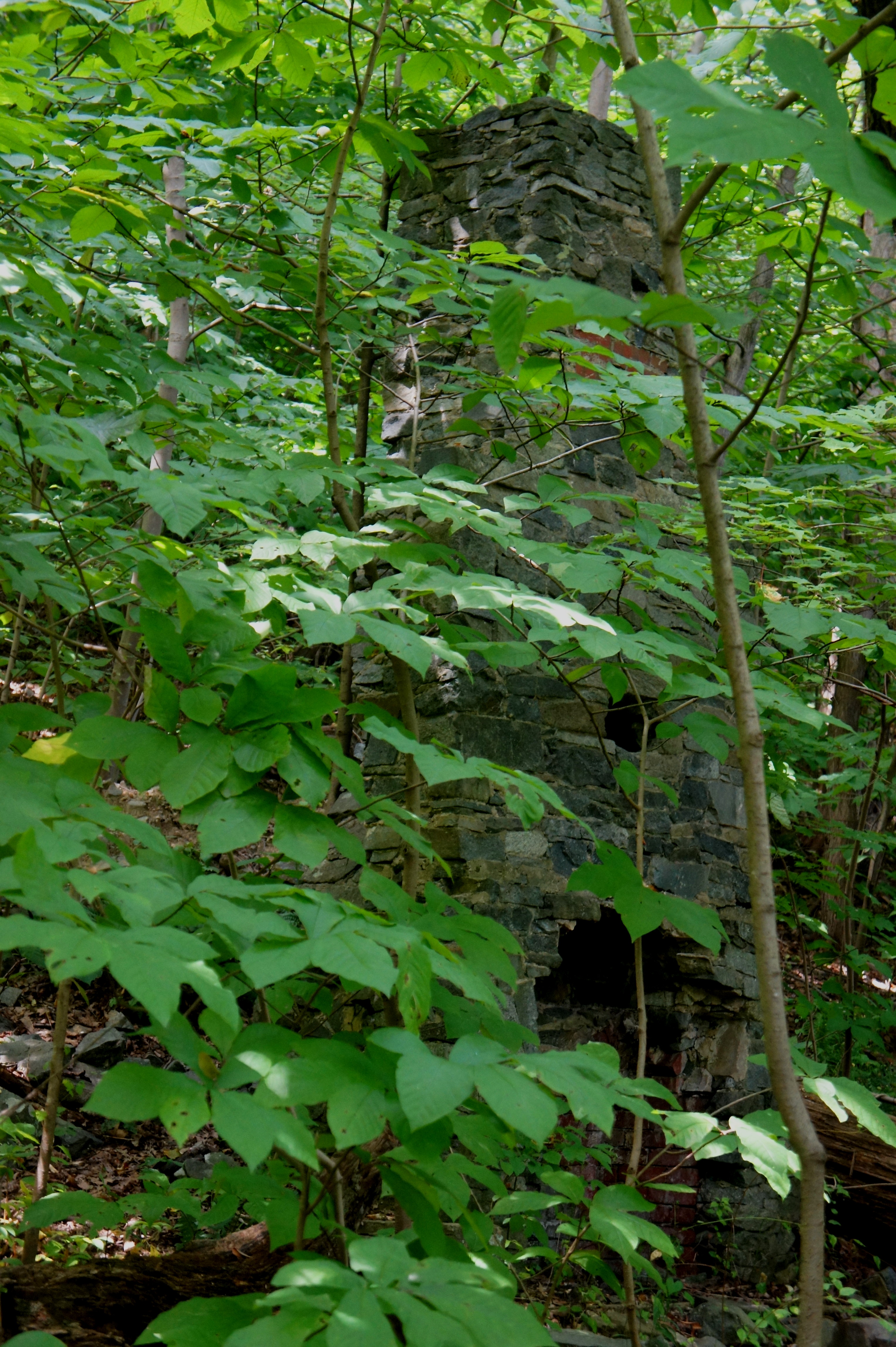
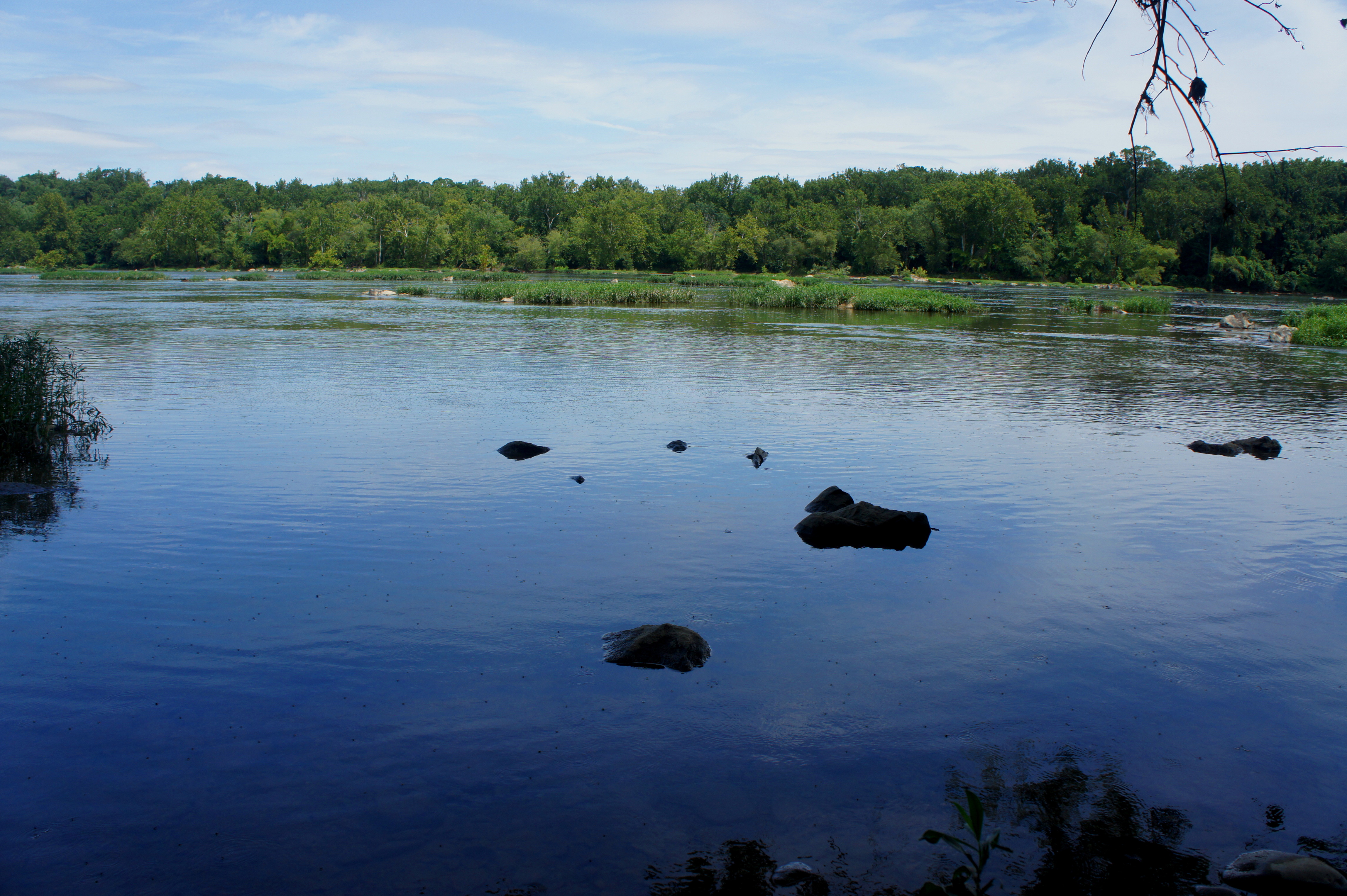
The sound of the GW Parkway gradually dissipates—even disappears—replaced instead by the chirps of birds and insects. All of a sudden, as the PHT bends west, a muddy drainage full of standing water appears—beyond this snaking channel lies the Potomac River, at last. After rock hopping a minor creek crossing, the route parallels the Potomac, offering occasional views through to the wide waterway. Unlike upstream at Great Falls, the river here is peacefully still.

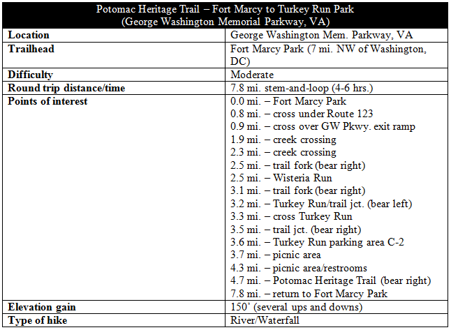
A short distance past the first creek crossing, the trail approaches from behind a large but antiquated sign meant to warn river runners. It reads: “STOP DAM AHEAD DEADLY UNDERTOW GET TO SHORE.” A few minutes later, hikers encounter a second stream crossing, this one sporting a minor cascade upstream to the left. Hiding amid the trees on the far bank are the remains of a stone chimney—accounting for part of the “heritage” of the Potomac Heritage Trail.
The owners of this old hearth probably found serenity in the Potomac, which beyond this point begins to flow more briskly. A brief interruption in tree cover gives way to a brushy meadow offering unobstructed views of the river. Roughly 2.5 miles from the start, the trail forks: to the left, the Woods Trail climbs up to Turkey Run Park’s “Park HQ, Restrooms”; to the right, the PHT continues on. Bear right for now—you will return to this point via the Woods Trail, after a loop around the park.
The next ¾ mile through Turkey Run Park is absolutely splendid, and it’s arguably the highlight of the hike. Just past the trail junction, the PHT crosses Wisteria Run, a cascading ravine flush with its namesake.

The path beyond skirts the banks of the Potomac, offering excellent views of the river. On a nice summer day, you’re likely to spot fly fishers or kayakers. As marshy islands appear, the pace of the water flow picks up.
As does the difficulty of the PHT, which becomes considerably more rugged through Turkey Run Park. Hikers will encounter sporadically rocky terrain as the trail approaches the park’s namesake, situated a little over three miles from Fort Marcy. Bear right at the first trail junction, then descend to Turkey Run.
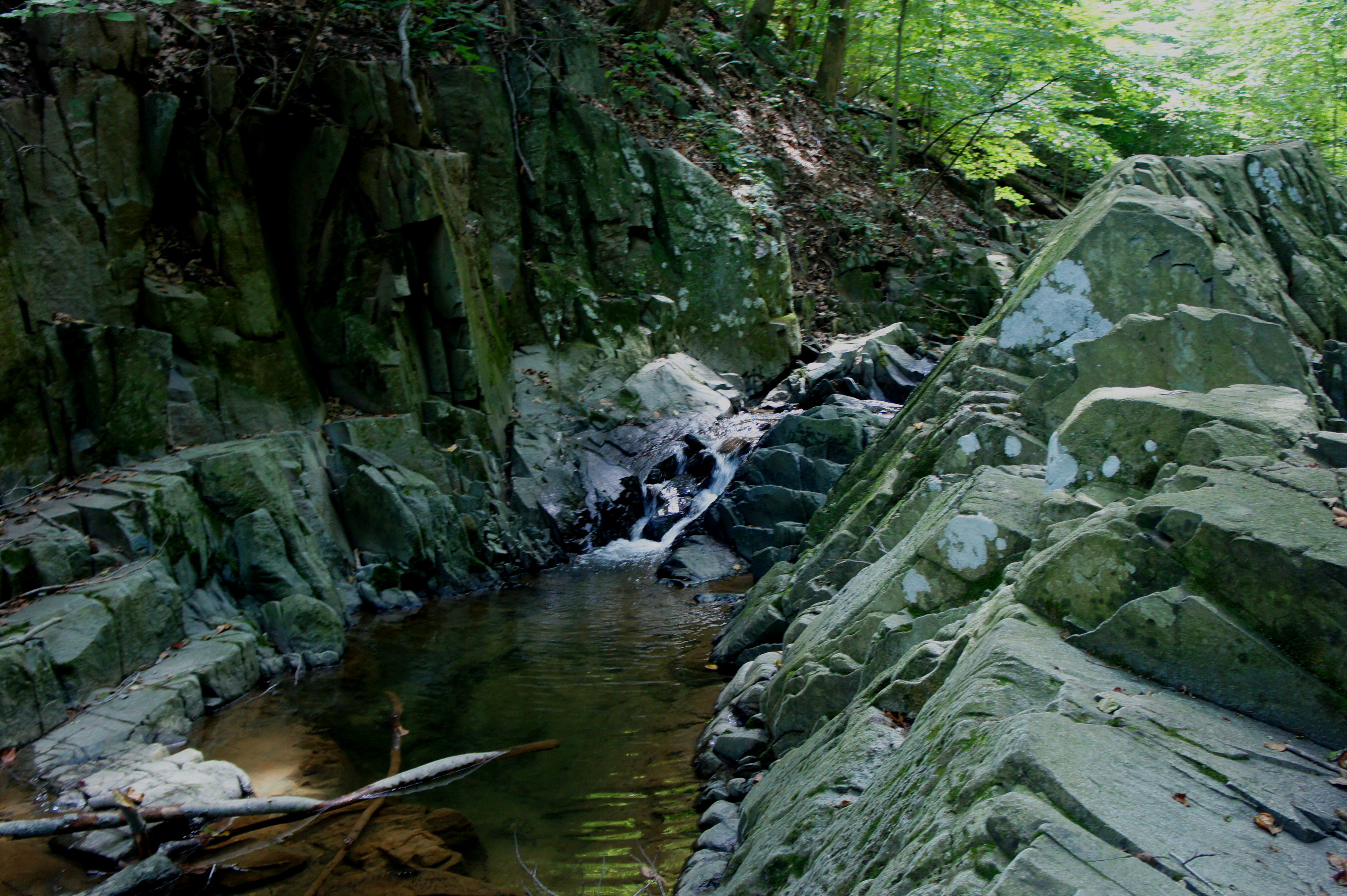
After tiptoeing across the streambed and up a short staircase, bear left at the next junction. For the first time, the route leaves the PHT behind, embarking on an alternative, 1.5-mile curve through Turkey Run Park. The first 1/3 mile follows the Turkey Run Loop Trail as it parallels the creek, crosses it, then ascends steeply to the park’s C-2 parking area. Stop along the way at a spot on Turkey Run where the creek tumbles into a pool wedged between walls of greywacke.
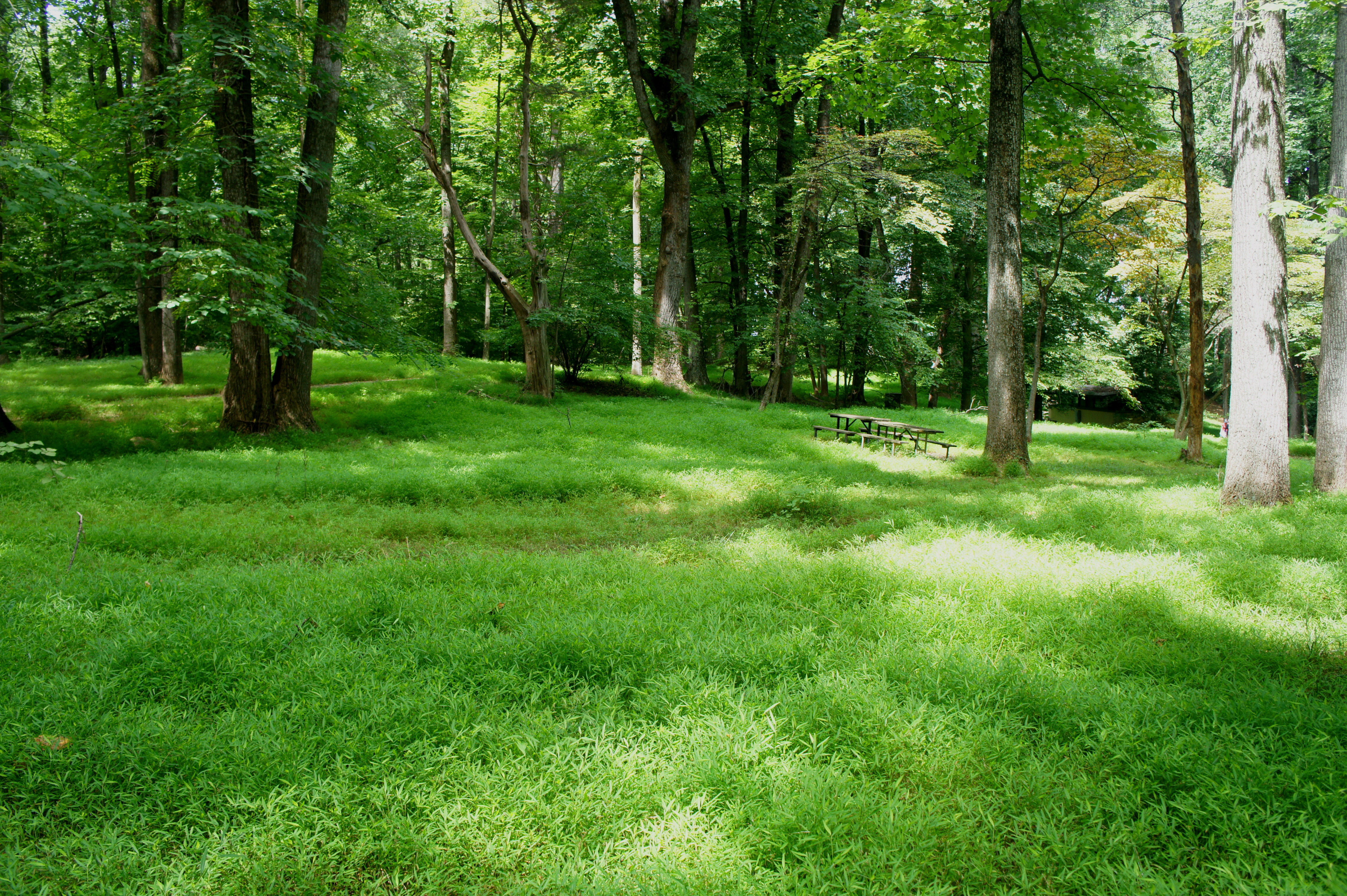
From the parking area, look across to the east for a maintenance road with a sign reading “service vehicles only.” This is the unassuming start to the mile-long Woods Trail, which connects back with the PHT. After passing a large and grassy picnic area, continue east as the trail leaves the road and traverses a series of ravines. Three wooden bridges are crossed in all, before the Woods Trail ascends to a second picnic area with restrooms behind the Park Headquarters.
From here, it is 1/3 mile, mostly downhill, back down to the PHT. Near its end, the path crosses Wisteria Run above the cascades and sneaks behind a 30-foot concrete tower (long abandoned) before completing the loop.

All that remains is the 3.1-mile return, amid streams and hills and the buzz of the GW Parkway, to the trailhead at Fort Marcy. The 7.8-mile round-trip, like the PHT section that precedes it, is a worthy workout.

Pingback: Potomac Heritage Trail – Turkey Run to Scott’s Run (George Washington Memorial Parkway, VA) | Live and Let Hike