

This 4.6-mile ramble from Turkey Run Park to Scott’s Run Nature Preserve in McLean, Virginia constitutes the third section of the Potomac Heritage Trail heading westward from Rosslyn in Arlington. (Note: Descriptions of the two preceding sections—Roosevelt Island to Fort Marcy and Fort Marcy to Turkey Run Park—can be found here and here, respectively.) Despite a handful of steep climbs, it is arguably less challenging than other sections downstream and features riverside views and three beautiful creeks, each with tumbling cascades feeding into the Potomac. A short detour to Scott’s Run Falls punctuates the scenic walk. Park one car at Turkey Run and a second at Scott’s, or return the way you came for a 9.2-mile out-and-back (or shorter, if you take a shortcut route through Scott’s Run Nature Preserve).


The hike
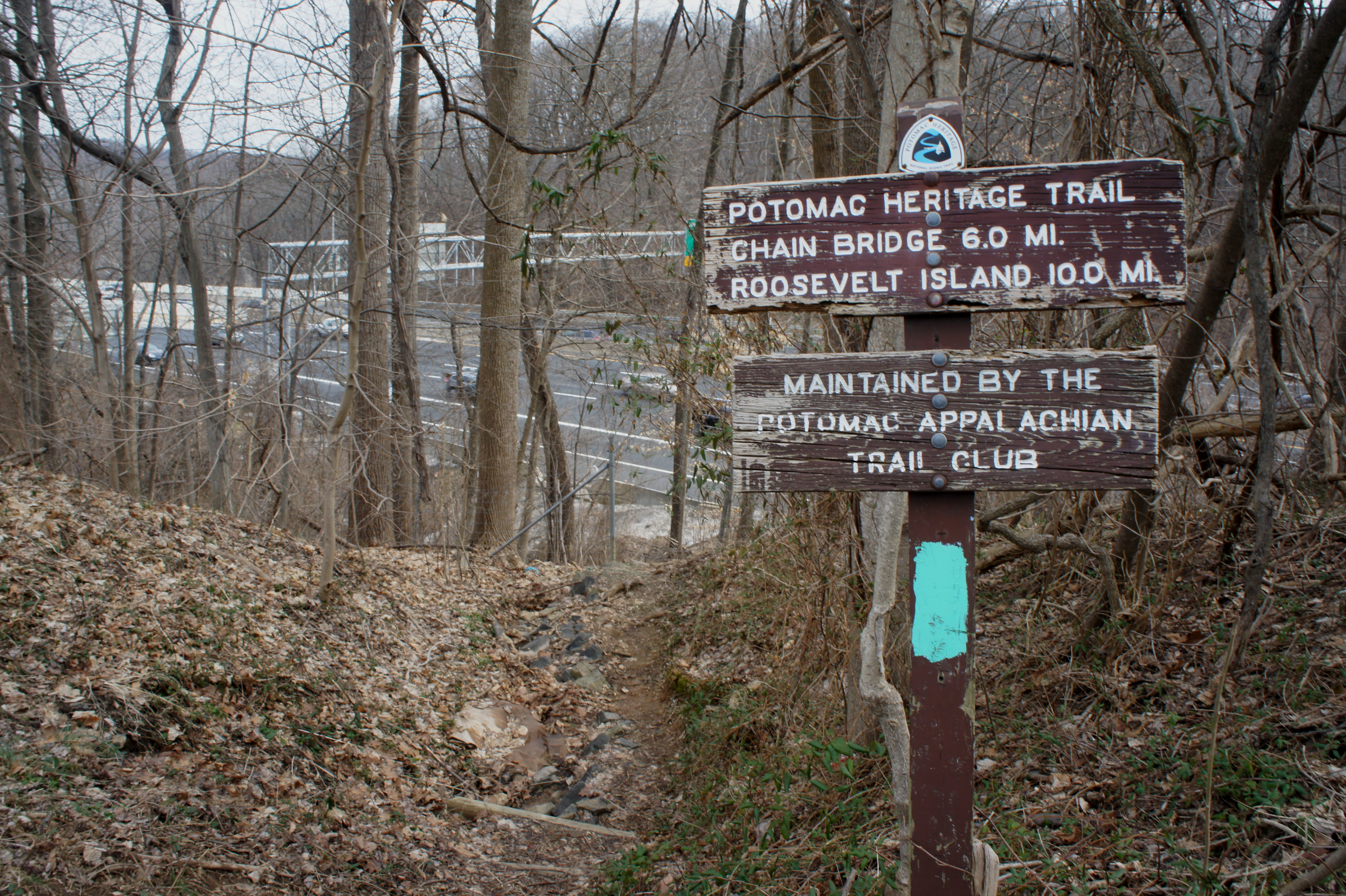
To start, park at the C-1 (or C-2 on some maps) parking area in the northwest corner of Turkey Run Park, the first lot reached (on your left) as you enter from George Washington Memorial Parkway. Bear straight on the obvious trail, which serves as the access route to the Turkey Run Loop Trail and Potomac Heritage Trail. After 1/10 mile, bear right at the fork, then descend a set of steep staircases, blended with winding switchbacks. Here the trail drops nearly 150 feet in a couple hundred yards. The sharp descent ends at a three-way junction; bear left (west) on the Potomac Heritage Trail (PHT).

The PHT runs, with several interruptions, from Prince William County south of DC all the way to Loudoun County, eventually connecting with other trails that extend all the way to Pittsburgh. The Turkey Run to Scott’s Run section is relatively popular, though the crowds thin out in the middle. Once you have crossed Turkey Run—about 1/3 mile from the start—the trail embarks on 1.5 miles of quiet, uninterrupted wilderness. Unlike other sections, the PHT here maintains a healthy distance from noisy GW Parkway (though careful listeners will probably still hear buzzing cars to the south).
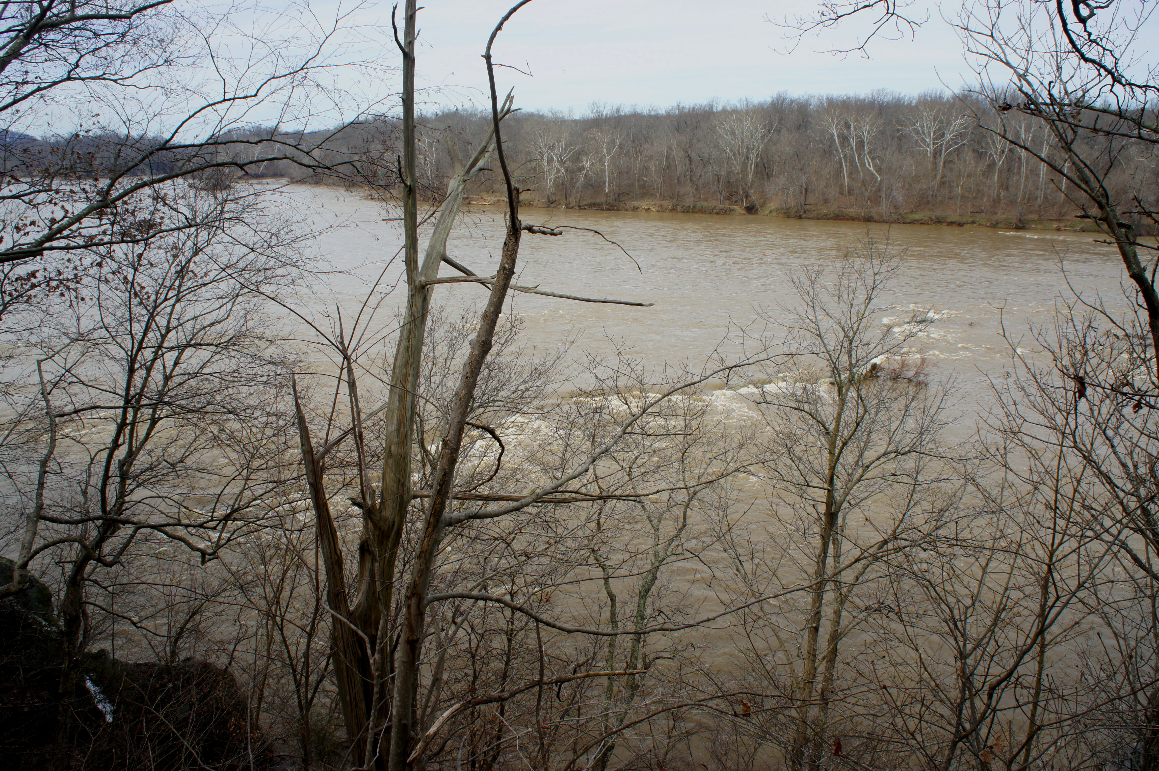
Shortly after Turkey Run, the trail buts up against the banks of the Potomac River, here relatively calm (compared to sections upstream and downstream). Roughly 7/10 mile from the start, hikers cross a small, stony streambed; 400 yards later, the trail wraps around a rocky knoll, where some minor scrambling is required. Just under a mile from Turkey Run Park, the trail cuts southwest, away from the river, through a swampy area and crosses another minor creek.

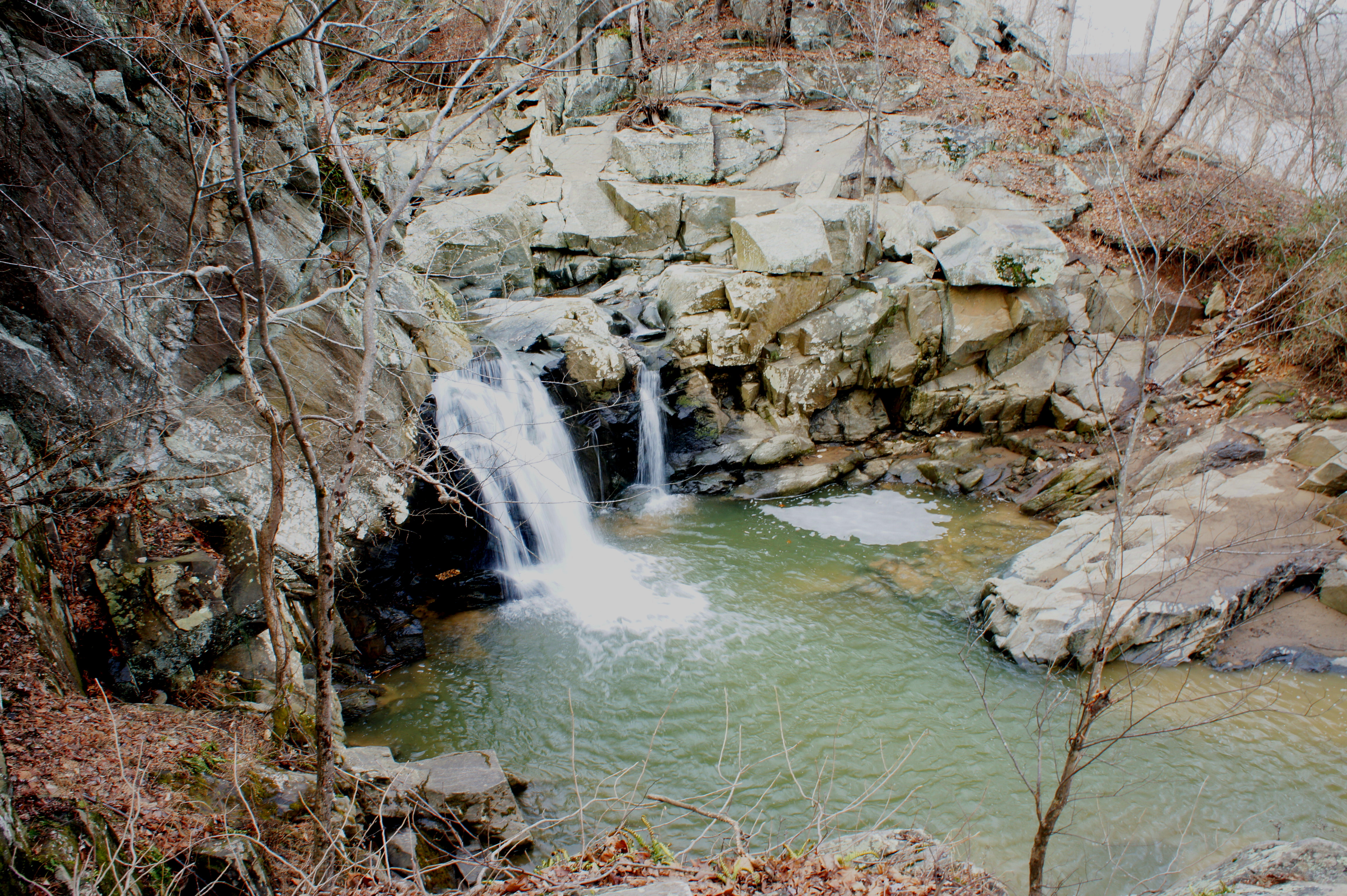
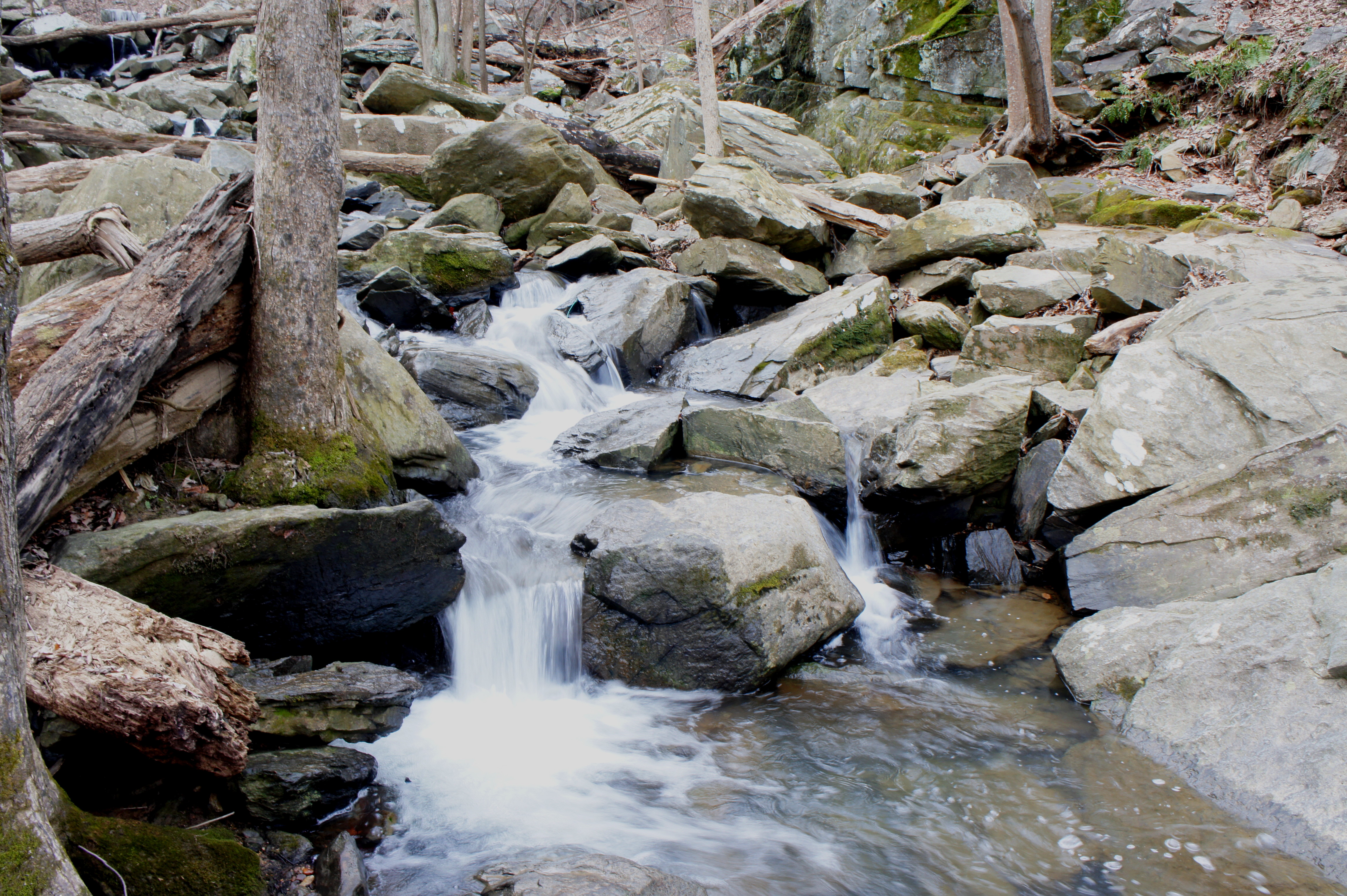
At 1.3 miles, the PHT descends a set of steps to Dead Run, a beautiful stream despite its ominous name. (Note: Bear left, before crossing the creek, for a circuit option back to Turkey Run.) Here Dead Run drops over a series of lovely and photogenic cascades—with a significantly higher flow in spring or after rainfall. Crossing Dead Run can be a challenge, but it’s quite possible—with secure footing—to hop from rock to rock to the opposite side. Stop here for a short break before continuing on, as the PHT climbs out of the streambed and veers off to the right.

Jagged bluffs tower over hikers for the next ½ mile, while the trail skirts the banks of the Potomac. In the event of high waters or recent floods, this section can be testing, as the river sometimes encroaches on the trail itself, submerging the route in milky puddles and thick mud. In summer, the dense thicket provides no easy bypass, but it’s possible in the winter season to climb partway up the rocky and brushy slope on the left to avoid the muck. Just before passing under Interstate 495 (the American Legion Bridge), return to the riverbank.

Alas, the next mile or so is less than ideal, starting with the smelly underpass below the Beltway. With a deluge of cars whizzing above, cross a small wooden bridge and take a left at the fork (counterintuitive, as it bears away from the river). For the next 100 yards, the path climbs steeply, following a small stream littered with black tarps and pipes. The dirt path ends at residential Live Oak Drive, where the PHT goes on a short hiatus.
From here, walk down Live Oak Drive—past many ornate McLean mansions—for 8/10 mile. The PHT resumes again at the far side of the private parking area at the Langley Club, behind the pool and tennis courts. Look for aqua blazes, the designated marker for the PHT.
Here the trail enters Scott’s Run Nature Preserve, a popular destination for northern Virginia residents. Foot traffic in this quiet corner of the park, however, is rather sparse. Shortly after leaving the Langley Club parking area, bear right at the first trail fork, then left at the second one. Here once again the PHT enters uninterrupted nature, free of cars and housing developments. At the 3-mile point, bear right at the four-way trail junction (again following the aqua blazes). The PHT beyond descends gradually through a woody ravine, coming within striking distance of the Potomac River. Bear left at the next trail junction; the spur trail to the right quickly dead-ends at the banks of the Potomac.

Now bearing westward, the PHT follows a hillside, remaining several dozen feet above the floodplain below. At 3.4 miles, the trail crosses a trickling creek and skirts rocky bluffs with commanding views of the Potomac River and Stubblefield Falls, a short rapid on the waterway below that is popular with kayakers. Hikers reach the highest bluff at around 3.5 miles, where a four-way junction connects several trails. To the right, it’s a short walk out to the Stubblefield Falls Overlook, perched high above the namesake rapids. To the left, the yellow-blazed Stubblefield Falls Overlook Trail ascends a hill en route to the Scott’s Run parking area. Stay straight on the PHT.
After traversing another small stream, the trail drops back down to river level, traversing the boggy floodplain. The sudden mass of crowds (at least on a nice day) indicates that Scott’s Run Falls—the park’s feature attraction—is near. Bear right at the next trail junction, crossing a concrete water treatment platform to the sandy viewpoint at the base of the falls.

Scott’s Run Falls drops only 12 feet, but its significant water flow and attractive plunge pool makes it better known than its higher neighbors (e.g., Dead Run, Windy Run Falls). The falls slice through a wall of greywacke sandstone and feed almost directly into the Potomac, situated in plain view off to the right.
It’s possible also to backtrack 30 yards or so, bear right, and climb up to a nice viewpoint overlooking Scott’s Run Falls from an angle. Climbing farther to the lip of the falls can be dangerous, however, and thus not encouraged. Return to the main trail and head right, up the well-trodden, partly-graveled path heading north.
This final section—dubbed on some maps as the “River Trail”—is wide, popular, and straightforward. Follow the route up through a leafy gully, bearing right at the trail fork at 4.0 miles. From here the PHT descends gradually to Scott’s Run, where the trail crosses just upstream from a pretty group of 2-foot cascades. Concrete stepping stones facilitate the easy traverse. After another 2/10 mile, the trail crosses Scott’s Run again—also straightforward—and passes another trail junction (the orange-blazed Trillium Hollow Trail bears left into the woods). Finally, at around 4.6 miles, the PHT ends at the often-packed parking area off Georgetown Pike.

This is the spot to park your second car if doing the 4.6-mile shuttle hike. If there’s no car waiting for you, either make your way back the same way for a 9.2-mile round-trip—or shave off around a mile by bearing east on connector trails and the blue-blazed Oak Trail, which returns to Langley Club and Live Oak Drive. From here, it’s 2.7 miles of retracing your steps back to Turkey Run Park.

Extra credit
Combined with the two preceding sections, the PHT runs from Theodore Roosevelt Island to Scott’s Run for approximately 12 miles. Try the other two segments, which are detailed in previous blog posts found here and here.

Pingback: Horsepen Run Trail (Horsepen Run Stream Valley Park, VA) | Live and Let Hike
Pingback: Yellow Trail Mystery Solved – Stubblefield Falls | Maryland Travel Stories
Pingback: Top 10 Hikes of 2016 | Live and Let Hike
Pingback: Billy Goat Trail – Section C (Chesapeake & Ohio Canal National Historical Park, MD) | Live and Let Hike