After 229 miles in Pennsylvania, the Appalachian Trail (AT) spends a relatively brief 41 miles running through Maryland, mostly following the lengthy ridgeline of South Mountain. While thru-hikers will breeze through the state in 2-3 days, day-trippers can complete the Maryland portion in seven discrete sections. (Note: This is the breakdown outlined in the excellent Appalachian Trail Guide to Maryland and Northern Virginia and accompanying map.) Maryland Section 1 is the northernmost section and extends from Pen Mar on the Pennsylvania border to Raven Rock Hollow; highlights include a shady rock amphitheater at Raven Rock, a spur to the intriguing Devil’s Racecourse, and beautiful views from Pen Mar Park and High Rock (though the latter is marred by disgusting graffiti). While not the longest section, Maryland Section 1 is arguably the toughest, boasting both the highest point (High Rock) and the steepest climb on the Maryland AT. (Note: The description below includes short detours from the main AT to High Rock and Devil’s Racecourse. Skipping these two spurs shaves 9/10 mile off the hike; or just skip the 0.8-mile round-trip spur to Devil’s Racecourse for a 6.0-mile total, one-way.)


The hike
The challenge with day hiking Appalachian Trail (AT) sections, of course, is the lack of loop options. Maryland Section 1 runs approximately six miles from Pen Mar, Pennsylvania to Raven Rock Road in Maryland, requiring either a pick-up at the end or doubling back across the same terrain for a 12-mile round-trip. (Note: Lacking a second car, I chose the latter.) In any case, I would recommend starting at Pen Mar, where there are far more parking options than the southern end at Raven Rock Hollow.
Reaching the town of Pen Mar, which straddles the Pennsylvania-Maryland border, the main parking area for Pen Mar Park is situated at around 14609 Pen Mar High Rock Road. The ideal parking spot, however, is situated ½ mile up the street at around 13355 Pen Mar Road in Pennsylvania. Here there is a very small gravel lot on the left, with space for no more than three cars; the official start of the section begins just beyond the overgrown metal gate marked “No Motorized Vehicles.” (Note: If the parking spots are full, backtrack to Pen Mar Park and park there. You will have an opportunity from here to hike north for 3/10 mile, back to the PA/MD border and to the official start. All overnight backpackers must park at Pen Mar Park in the overflow lot, which is situated just outside the park gate and requires a permit.)
With parking squared away, it’s time to begin the hike. From the official starting point off Pen Mar Road, the trail skirts around the metal gate and crosses an overgrown field while passing under power lines. After entering the woods, a sign on the left (with some poor grammar) indicates that you are walking on an old trolley line. Just beyond, hikers will cross over the Mason-Dixon Line into Maryland, a feat marked by a large sign and trail log on the right.

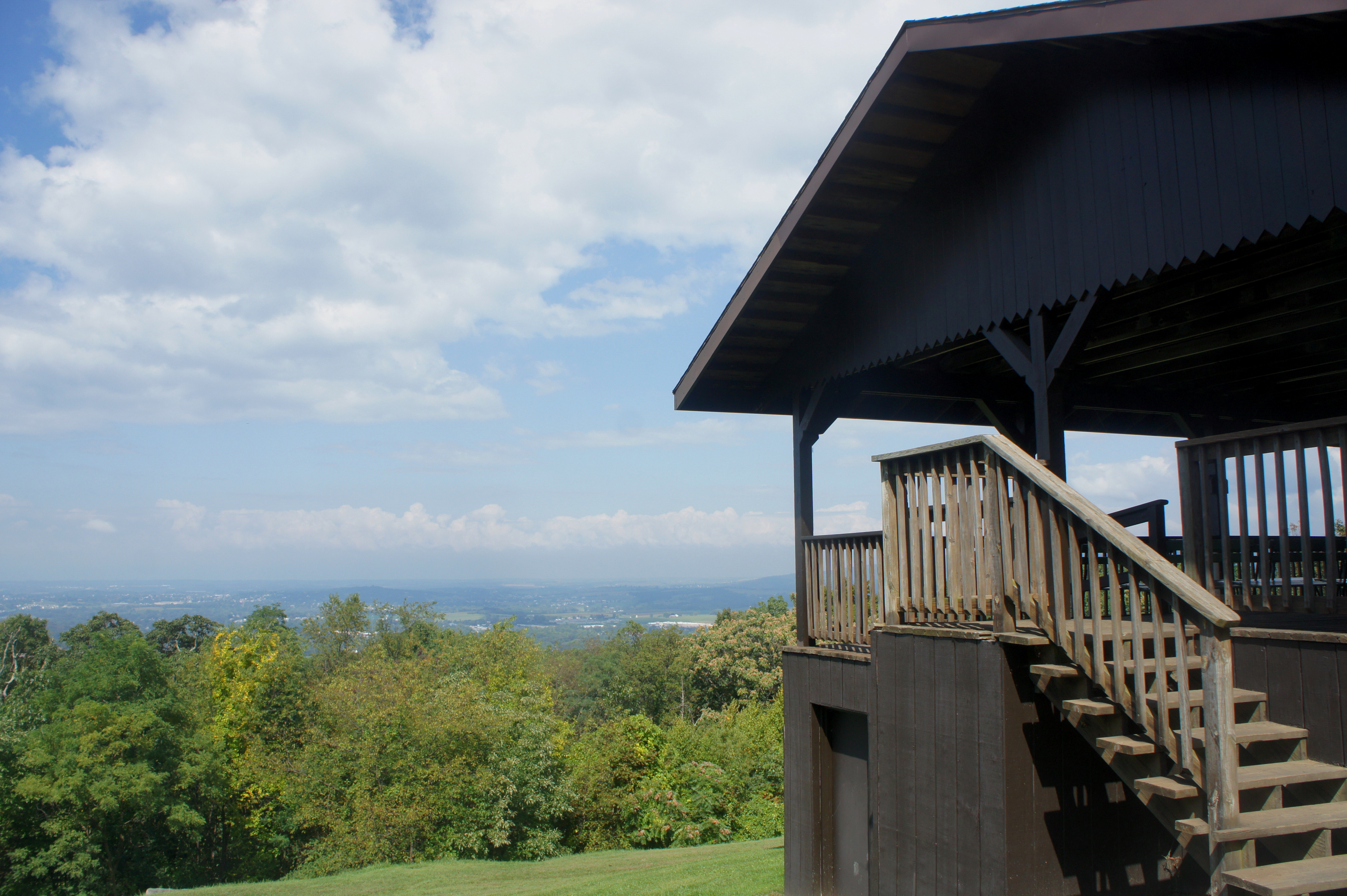
From here bear east, climbing uphill to a set of railroad tracks. Carefully cross the tracks and bear right at the trail junction. Now heading south, follow the wide path as it skirts a metal gate and enters Pen Mar Park. At 3/10 mile, the trail emerges from the woods and onto a grassy meadow; this is the heart of Pen Mar Park, complete with a playground, dance pavilion, picnic tables, and a covered overlook with tremendous views of Cumberland Valley to the west. (Note: The town visible below is Waynesboro, Pennsylvania.) Pen Mar Park was previously an amusement park and resort, a popular stop on the Western Maryland Railway. After more than 60 years in operation, the amusement park closed in 1943, reborn as a community park in 1977.

The AT continues between the overlook and the dance pavilion and then passes a small shed as it reenters the woods at about 4/10 mile. Remains of a historic rock wall are found on the left, paralleled by disturbed earth on the right that indicates former development. Nearby, down and to the right out of view, lies Glen Afton Spring, which provided the water supply for the amusement park at Pen Mar; it was decorated in 1879 with an ornate pavilion and railing around the pool.
Continue along the wide pathway until 0.55 miles, when the AT abruptly climbs up and embankment to the left and thins to a narrower track. (Note: Be sure to follow the AT’s white blazes, as the turn is easy to miss.) Just before the 1-mile mark, the trail begins a gradual ascent that continues for about the next half-mile. Look for a stone wall and large mound on the left at about 1.1 miles, the latest sign of former habitation in the Pen Mar area. At 1.4 miles, the AT intersects an old grade and then enters a very rocky section of the hike.
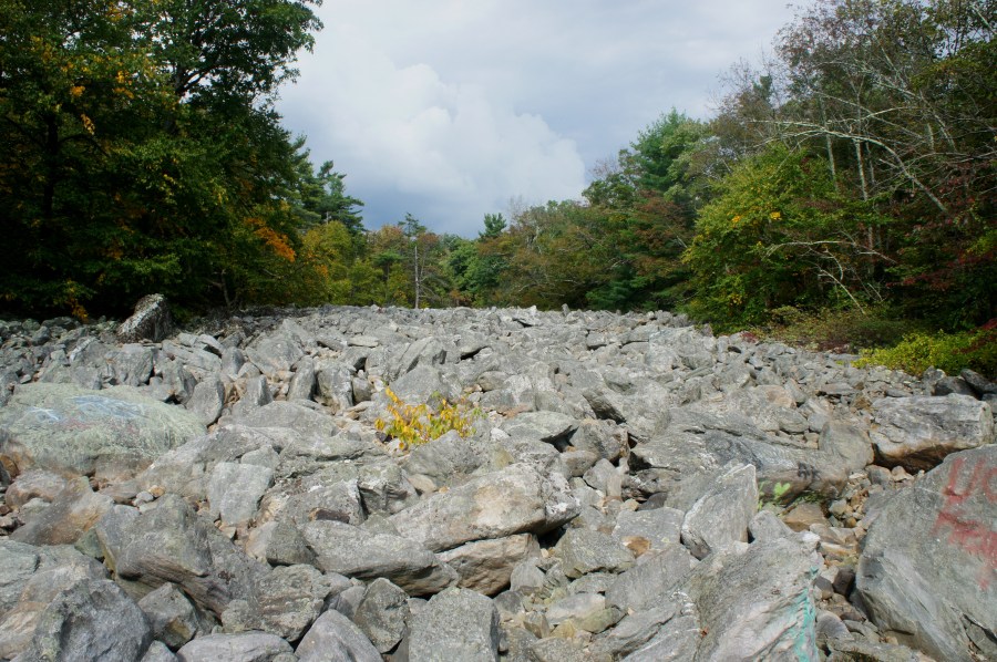
As the ascent turns to descent, the trail crisscrosses a boulder field, in which it is difficult to follow the trail; again, be sure to look for white blazes, which guide hikers through the maze of rocks. For a brief moment, the boulders dissipate and give way to a thick underbrush. At around mile two, however, the trail cuts across another rock slide, this one more gnarly than the first.
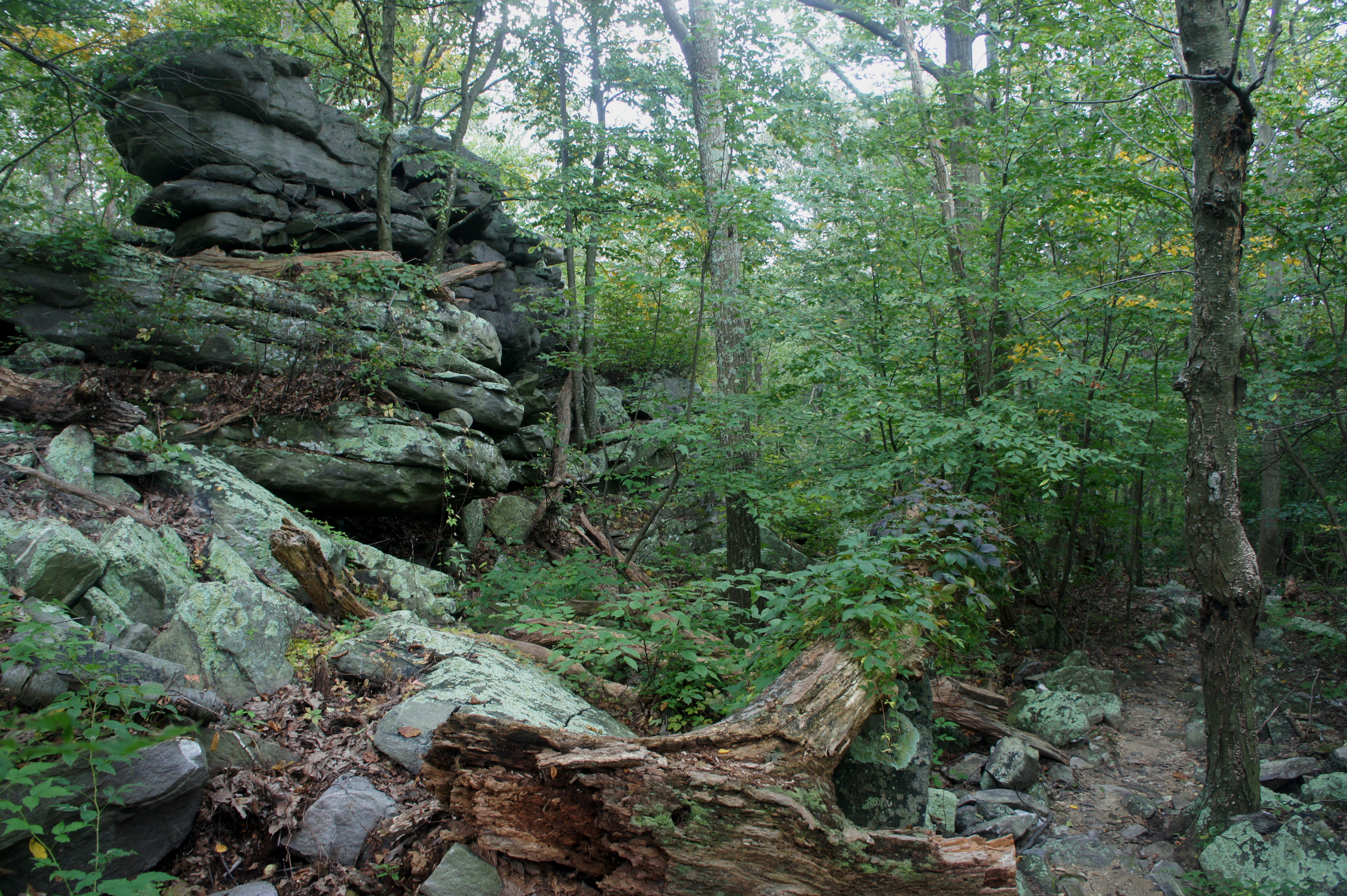
After reaching a local low point at about 2 ½ miles, the AT begins its sharpest ascent in Maryland. Inaugurated by two large boulders on the left, this section features stony steps, switchbacks, and a relentless grind, gaining more than 500 feet in 4/10 mile. Fortunately, it is also scenic: a left-hand bend at 2.75 miles offers some limited views of Cumberland Valley, followed by a chiseled wall of quartzite on the right at the 3-mile mark.


Just beyond, the trail reaches a small flat between two striated shelves of rock—ostensibly a nice camping spot. Then the path cuts left and climbs again, finally surfacing in about 70 yards at the end of the steep ascent. Various rock outcrops, mostly on the left, offer some limited views to the west.
By now you are approaching High Rock, which is accessed by a spur trail that intersects the AT at around 3.1 miles. Turn left on the blue-blazed path and follow it for 1/10 mile to the High Rock parking area, sure to be swarming with people on weekends during much of the year. The viewpoint at High Rock once hosted a tall lookout tower; today it is relegated to a concrete platform—which now is covered in a disgusting amount of graffiti that detracts from an otherwise terrific vista.
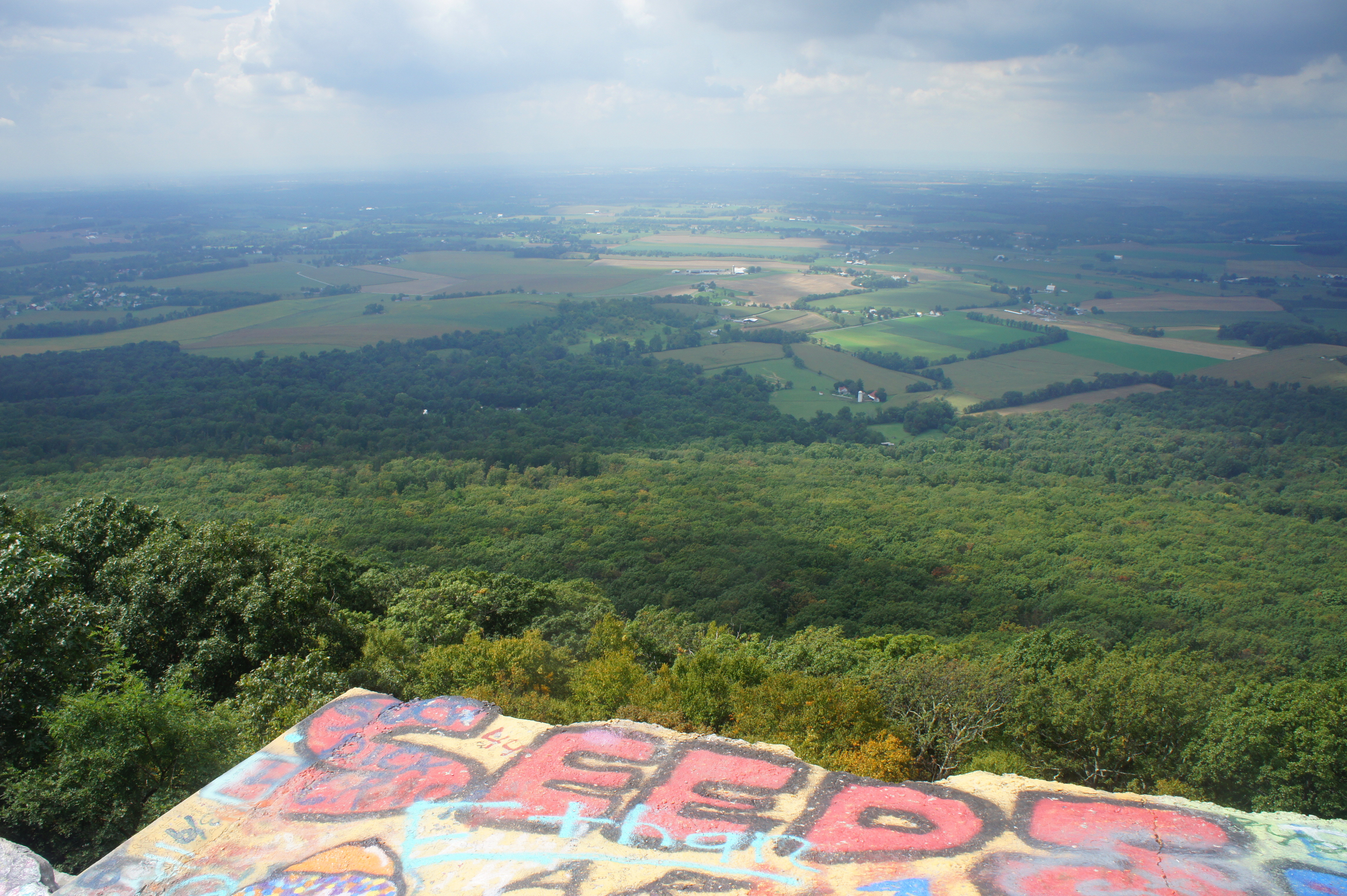


Focusing on the view, Cumberland Valley unfurls below in a patchwork of fields and wood lines; the Blue Mountain range and Bear Pond Mountains form the western end of the wide valley on the distant horizon. To the north, South Mountain juts out into the valley, with the town of Waynesboro at its feet.
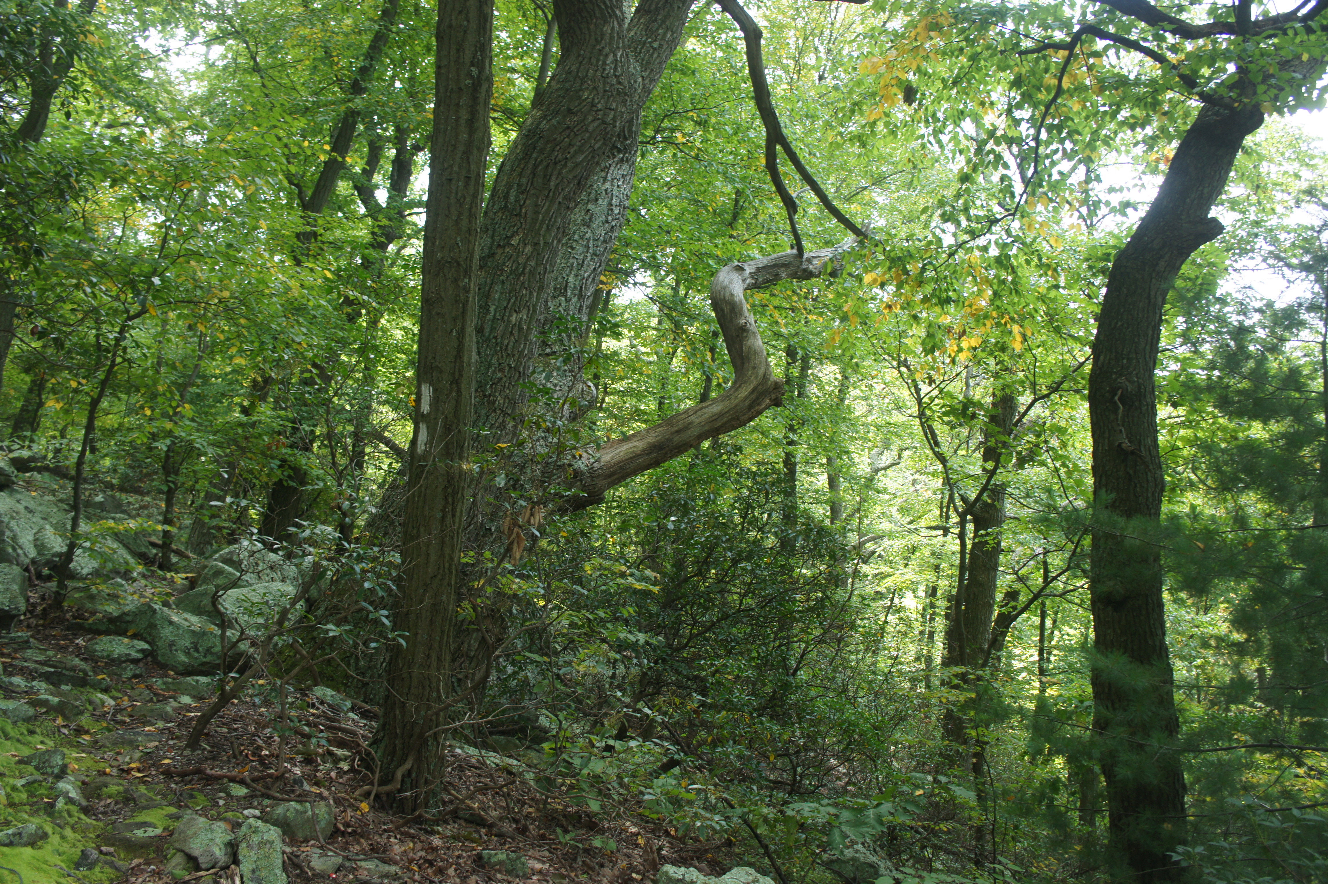
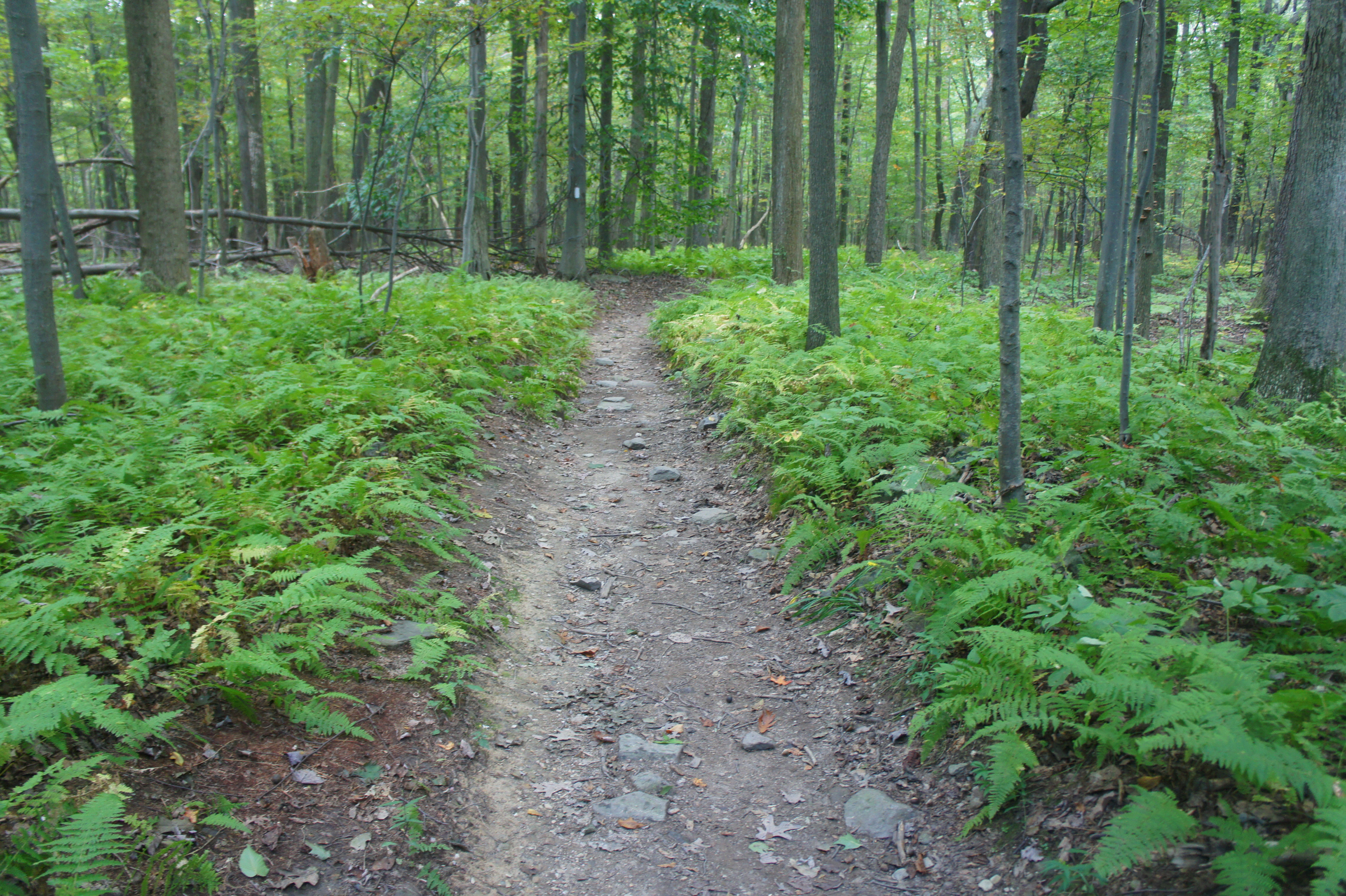
Leaving the platform behind, look for blue blazes heading east (to the left of where you entered). Follow this path for 1/10 mile, where it returns to the AT. Stay left and climb gradually through a sea of mountain laurel as the trail bears southeast. At the 4-mile mark, the trail passes a local high point on the southwestern slope of Quirauk Mountain then begins to gradually descend. The next mile is relatively uneventful—the most interesting break from the monotony of constant tree cover is the proliferation of yellow-green ferns.
Five miles from the trail’s start, the AT reaches a signed junction. To the left, a blue-blazed path leads downhill to a natural spring and an interesting geological feature called the Devil’s Racecourse. Steps beyond, a second spur heads off to the right, leading 1/10 mile to the Raven Rock Shelter.
Determined hikers may skip these detours, but those with extra energy and curiosity can head left on the 4/10 mile route to the Devil’s Racecourse. This path drops 200 feet in 3/10 mile to an extensive natural spring system that should be reliable year-round. Beyond the spring, a slightly faded path continues east for 1/10 mile to a sudden break in the woods—a so-called “river of rocks” clogged with light grey chunks of quartzite. The Devil’s Racecourse formed during the most recent glacial period (roughly 85,000-11,000 years ago), when extreme freeze and thaw episodes caused the break-up for larger rocks along the ridges above. Following the stream of Rattling Run—still here but hidden below all the boulders—thousands of bits of quartzite settled in this low trough to form the feature seen today.

From the boulder slide, turn around and retrace your steps back uphill to the AT. (Note: Allot 30-45 minutes for this detour, which is 0.8 miles round-trip.)
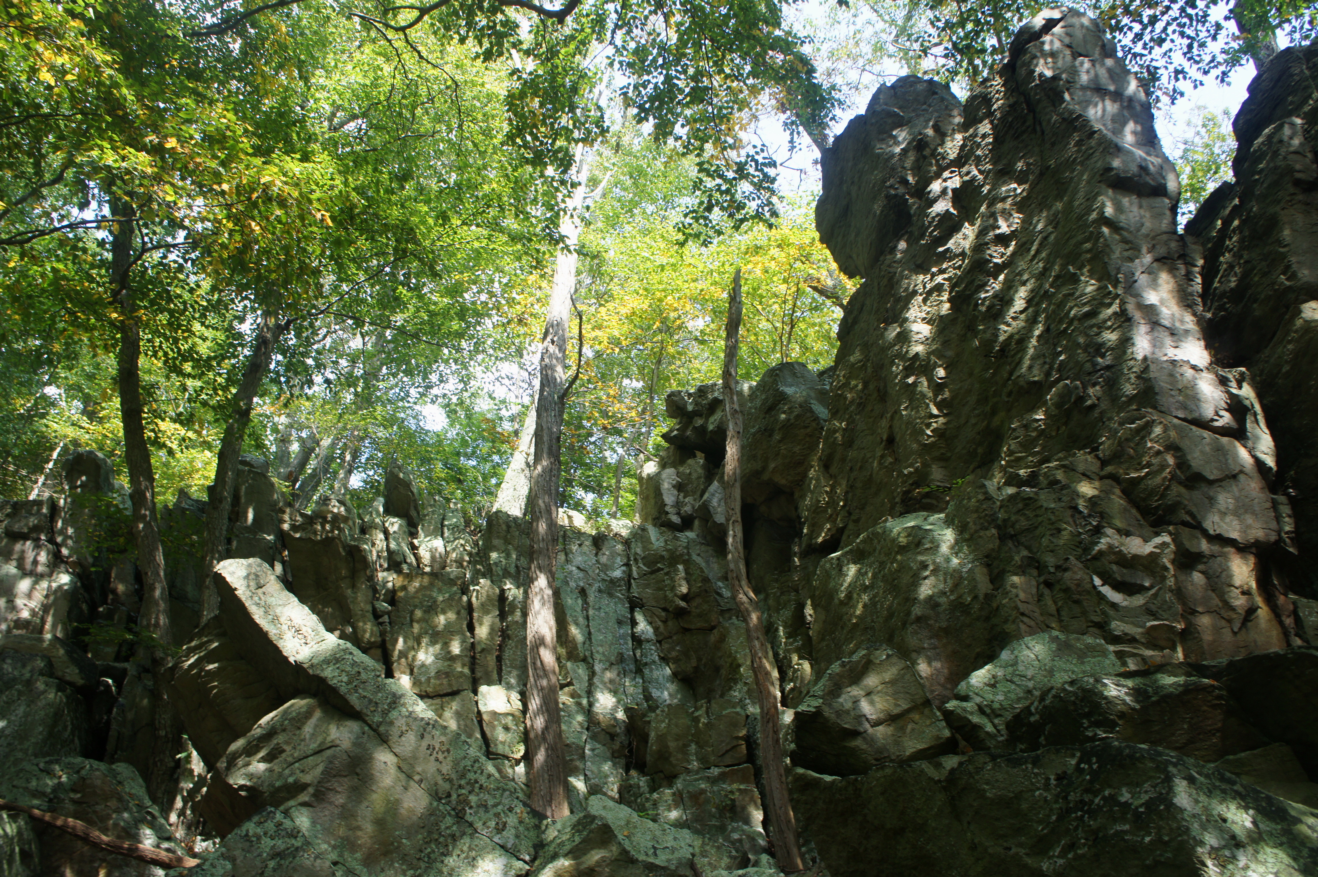
Continuing south on the AT, pass the spur to Raven Rock Shelter on the right, then begin a sharp descent at about 5.5 miles. (Note: 6.2 miles if you did the spur to Devil’s Racecourse.) For the hike’s finale, the trail drops nearly 600 feet in 6/10 mile. Along the way it passes a geologic wonder: an alluring rock-lined amphitheater filled with a jumble of boulders and surrounded by 10-20 foot walls. A short, blue-blazed spur trail leads to the Raven Rock cliff, which overlooks Raven Rock Hollow and Maryland Route 491 (Raven Rock Road).


Beyond Raven Rock, the trail edges westward and drops down a series of switchbacks, culminating with a sudden emergence onto Raven Rock Road, marking the terminus of AT Maryland Section 1. If you have a car waiting for you, this is the end of your hike. (Note: Parking is limited to the shoulder of the road.) Backpackers and ambitious day hikers can continue across the street to Maryland Section 2; for those parked at Pen Mar, it’s a 6-mile slog back to the car, making for a long and strenuous—but rewarding—day hike.


Pingback: Appalachian Trail – Maryland Section 2: Raven Rock Hollow to Wolfsville Road (South Mountain State Park, MD) | Live and Let Hike
Pingback: Top 10 Hikes in 2017 | Live and Let Hike
Our 65+ age group did this section yesterday (Oct, 2019), parking a second car at Pen Mar intending to end at the Raven Rock Shelter and to take a .3 mile side trail to Ritchie Road parking lot where we had parked a first car. Our only issue occurred at the 5.1 mile mark on the trail, which directed a .3 mile spur to the spring and, along the same path, a .6 mile spur to Ritchie Road. While this conflicted with our AT map, which listed a .3 mile spur to Richie Road, we opted to follow the sign. The spur was well marked in blue to the spring, but not beyond, where the trail and markings disappeared. We also saw no signs to the nearby Devil’s Racecourse. Since it was late in the day we opted to return to the AT and look for an alternate way to Ritchie Road. Finding none, we hiked down to Ravens Rock Road, with one stud of our group hiking over to and up Ritchie Road another mile to get the first car. Our phones measured over 9 miles in distance in what is listed as a 6 mile hike, and with the single return from the spring and the hike to start at the MD/PA line accounting for no more than one mile of the extra 3 miles. We would like to see better markings on the spurs to both Ritchie Road and Devil’s Racecourse. We found this section as advertised-strenuous in many places, and the rocks on the downhill trail caused many sore toes! It took us 6 hours to complete this section.
I did this hike yesterday from Pen Mar to the Racecourse and then out to the Richie Rd trailhead. We were confused for a moment once we got to the spring and found the blue blazed trail ending there. We backtracked a hundred feet back up the trail and found an unmarked trail leaving to the right (east) which led down the hill to the Racecourse and the Richie Rd trailhead. It is odd that this trail is not marked, and I can see how people might miss it. For us, Alltrails and Google Maps helped put the last pieces together since Alltrails shows the Richie Rd trail and Google Maps shows the racecourse on its satellite photo layer.
Fantastic review of this hike. I’m local to this hike but I’ve never done it yet. I’m trying to check off the MD AT sections. Not sure I can do 13+ miles in one day yet so I think just to Devil’s Racecourse and back will be great. Thanks!
Pingback: Top 10 Hikes in 2020 | Live and Let Hike
I lived at Pen Mar for alot of years when we were young the federal government would not allow cars you had to walk up High Rock Rd. now Washington County took it over thats when they started to deface High Rock its terrible site c is only a few hundred feet above High Rock you don’t get near that place run by the federal government towers knows every plane and ships on the east . I know the government is trying to get control of High Rock again and close it.They have to have there police running people out all the time after dark. High Rock is nothing but a place for durgs and beer parties Is a shame that Washington County Md. won’t do something about defacing the rocks High Rock was a place for hand gliders until 9 11 now they can’t because its to close to siteC
Pingback: Appalachian Trail – Virginia/West Virginia Section 1: Harpers Ferry to Keys Gap (Harpers Ferry National Historical Park, WV/VA) – Live and Let Hike