– Civil War Series –
Following General Robert E. Lee’s defeat the day prior at Beaver Dam Creek, the Confederate Army won a decisive but costly victory on June 27, 1862 in the Battle of Gaines’ Mill. Attempting to catch the Federal Army as it was retreating south to the James River, Lee sent the brunt of his force against Union General John Fitz Porter’s 5th Corps at a point outside Cold Harbor, Virginia. Although eventually succeeding in dislodging Porter’s troops, the Union’s strong position along the banks of Boatswain’s Creek produced scores of Confederate casualties, making the battle the Civil War’s second-bloodiest engagement to that point (behind only the Battle of Shiloh in April 1862). The battle was the third of the Seven Days’ Battles, which resulted in Lee’s successful defense of Richmond from General George McClellan’s Army of the Potomac.
A section of the battlefield today is protected as part of Richmond National Battlefield Park, situated in the Cold Harbor area northeast of Virginia’s capital city. An excellent 1-mile loop hike provides a tour of the grounds, now mostly covered in dense woods. Spur trails offer access to a monument for fallen soldiers, as well as an overlook of the area where Maj. Gen. James Longstreet’s division delivered the decisive blow that won the day for the Confederacy.

The hike
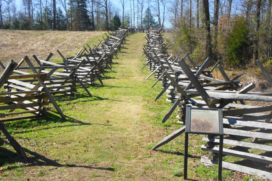
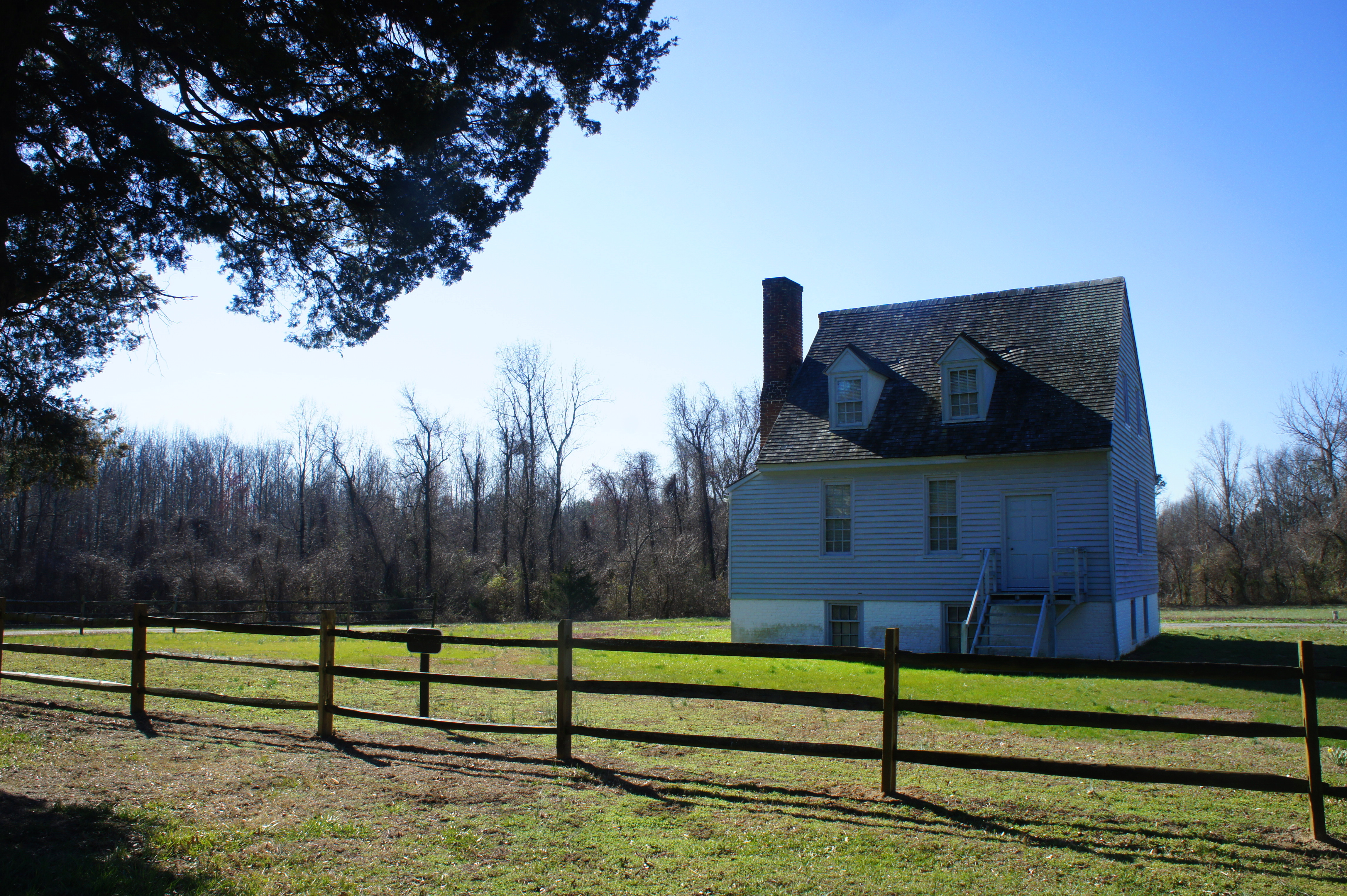
The Gaines’ Mill Trail is located a short drive southwest of the Cold Harbor Visitor Center in Richmond National Battlefield Park. Follow Watt House Road south as it crosses wood-laced Boatswain’s Creek and then climbs up Turkey Hill to an open field where the road ends. Next to the parking area and trailhead is the Watt House, once the centerpiece of a small plantation and a makeshift field hospital during the battle.
It was here at Turkey Hill that Porter positioned his forces to protect against a potential attack on the rear of McClellan’s army. In the early morning hours of June 27, McClellan decided to begin withdrawing the entire Army of the Potomac southward to the James River. To his commanders, this was billed as a “change of base”—but in reality, this was simply cover for what amounted to a retreat. According to historian Stephen Sears, McClellan decided that day that he was “quitting his grand campaign, surrendering the initiative, and giving up all hope of laying siege of Richmond from the line of the Chickahominy.”[1]

As day broke on June 27, however, Porter believed that his orders were to hold off a Confederate assault at any cost. Retreating east a few miles from Beaver Dam Creek, Porter’s 5th Corps set up a strong defensive position along Boatswain’s Creek. At the Watt House, Capt. William Weeden set up two guns aimed northwest across the woody ravine. (Note: This position is marked by two cannons today, within sight of the parking area.)
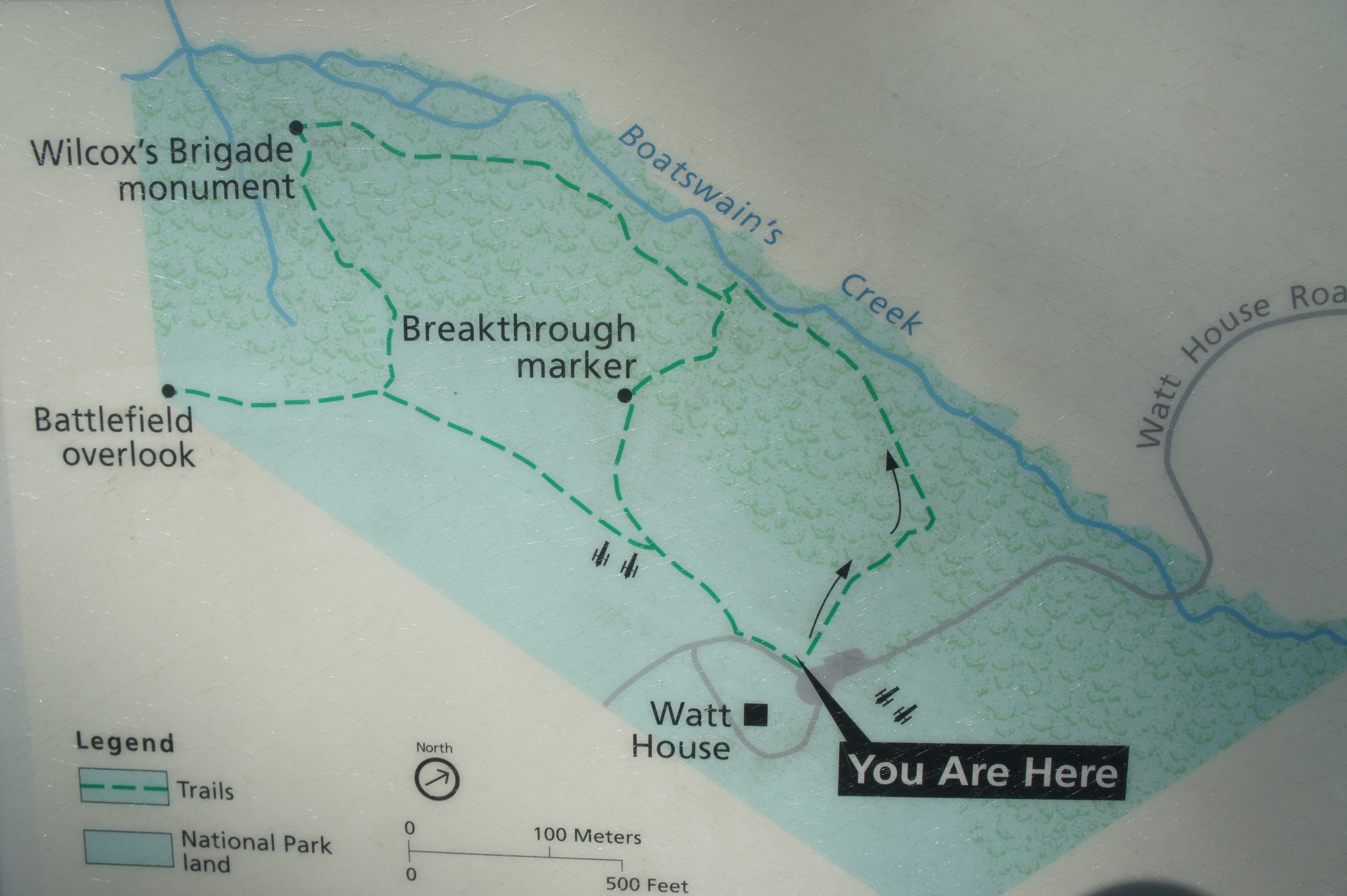
From the parking area, a dirt trail heads downhill off to the right, while a gravel road continues west across the grassy pasture. Bear right on the trail, beginning a counterclockwise loop around the Gaines’ Mill Trail (or Gaines’ Mill Breakthrough Trail, as it is officially called). The path makes haste for the edge of the woods, where an interpretive sign offers an overview of the battle. Beyond, the trail drops into the woody ravine, snaking down the north-facing slope at the heart of the action during the battle.
After a second sign, hikers will get their first views of Boatswain’s Creek, the boggy obstacle that separated the Union and Confederate forces for much of the day. At about 2/10 mile, the path flattens out and approaches the edge of the stream.
Following a minor skirmish at around noon, major fighting did not occur until around 2:30 pm, when Brig. Gen. Maxcy Gregg’s Confederate brigade attacked Union forces at a point roughly ½ mile east of your present location. Despite assaults all along the Federal line, Confederates largely failed to gain a foothold across the creek until very late in the day—when at last, at around 7pm, when Brig. Gen. John Bell Hood’s brigade pierced the Union defenses. (Note: Like at Beaver Dam Creek the day prior, famed General Thomas “Stonewall” Jackson was late to the fight at Gaines’ Mill.)
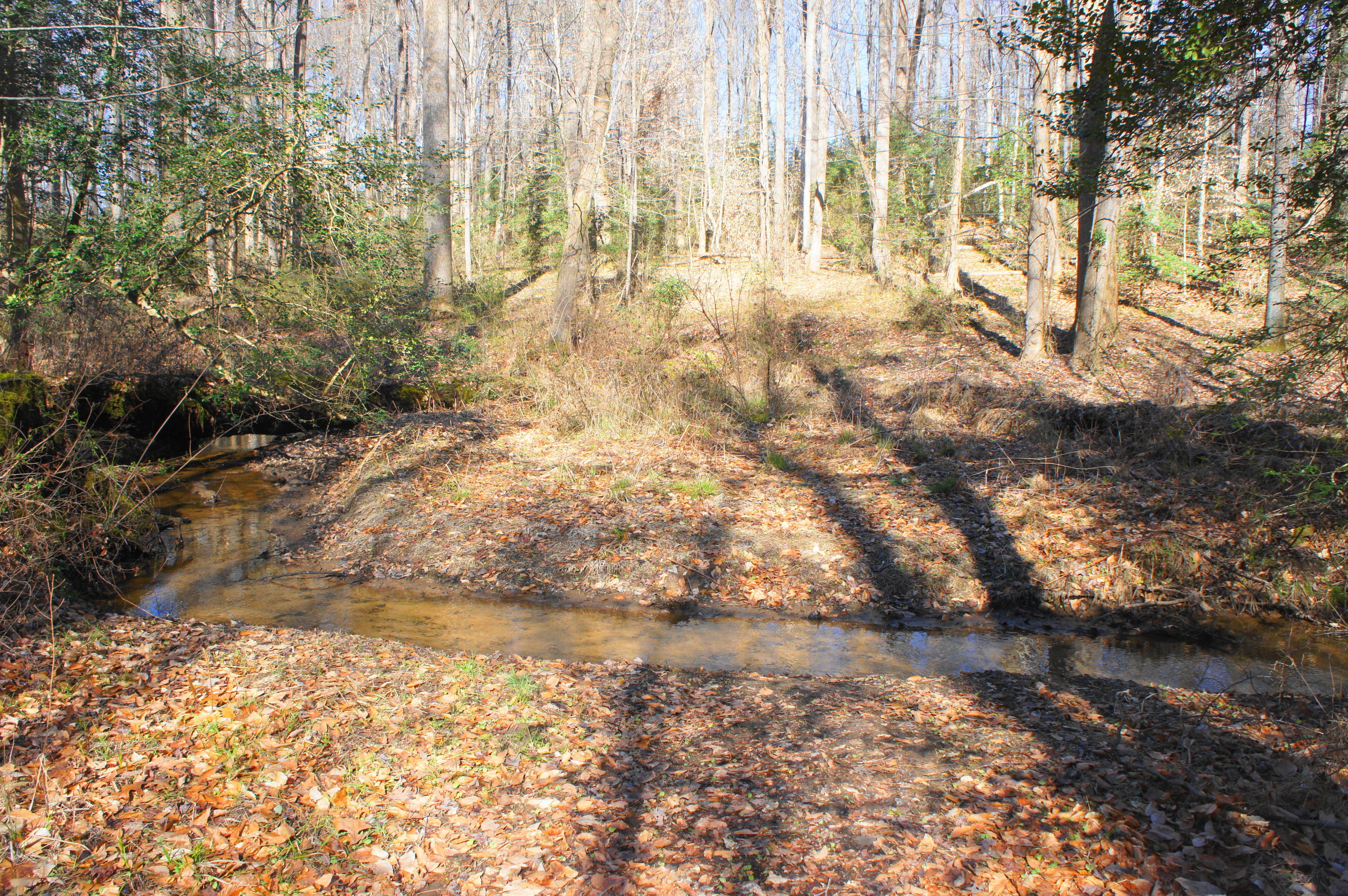
After following the gentle stream for around 150 yards, the Gaines’ Mill Trail reaches the decisive point where Hood’s brigade charged across Boatswain’s Creek. With the sun setting on the battlefield, Lee reportedly asked Hood: “This must be done. Can you break the line?” Hood’s response: “I will try.”[2] Try he did, eventually succeeding where dozens of other units had failed during the day.
From here the path leaves the creek and winds left up through a minor gap in the wooded hills. At about 0.3 miles, stay right at the trail fork. (Note: Heading left offers a shortcut back to the trailhead and passes a marker dedicated to Hood’s breakthrough in the Federal line.) The narrowing trail beyond ascends a minor slope amid a sea of beech trees.
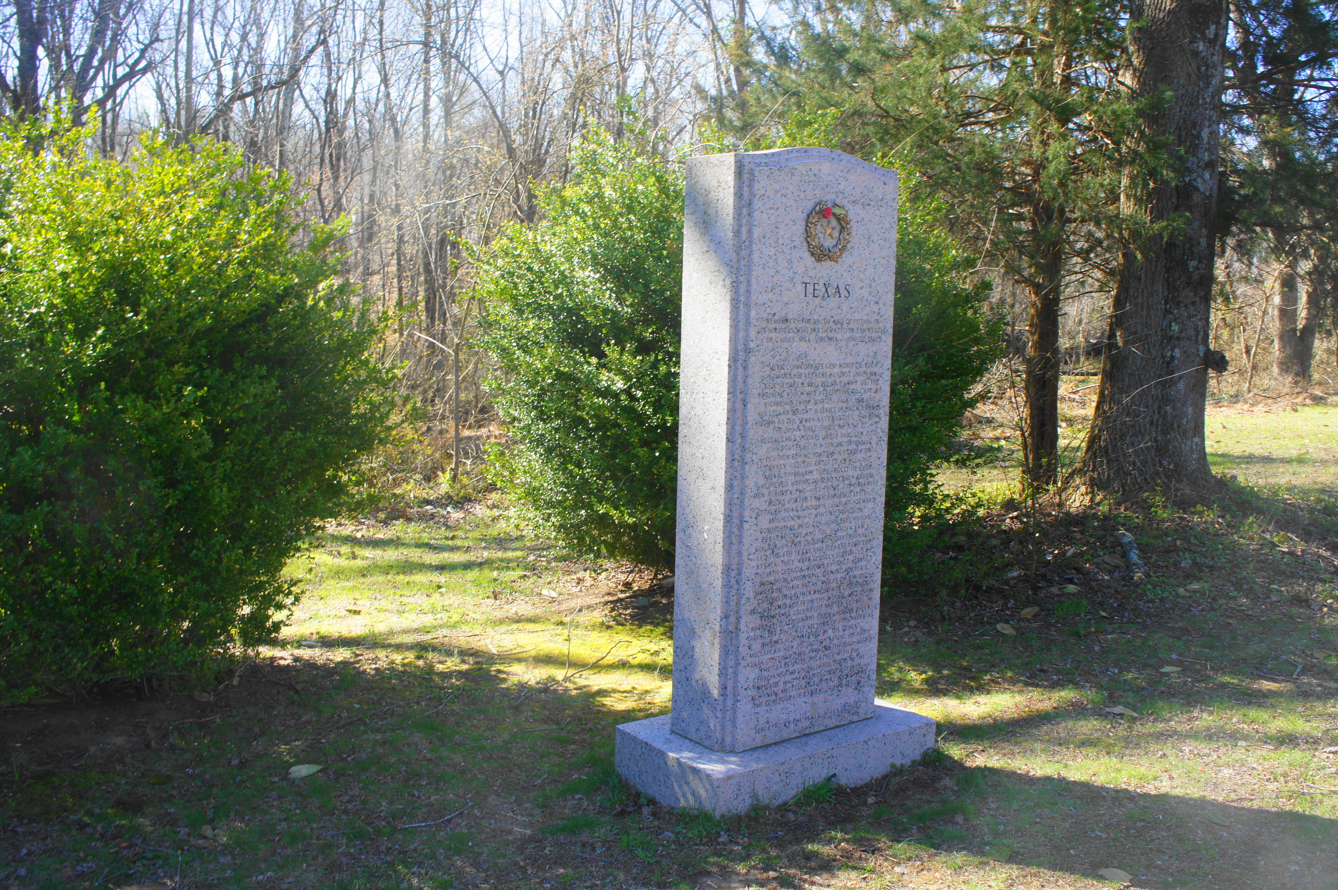
At 0.35 miles, a spur trail to the right offers a short detour for curious hikers. After crossing Boatswain’s Creek, the path climbs sharply uphill—effectively going behind the Confederate lines—and ends at a grassy patch with a granite monument to Hood’s “Texas Brigade.”
Beyond lies the gravel Watt House Road; while private property lies to the right, continue left to enter the vast, largely tree-less tract of land that was acquired and transferred to the National Park Service in 2014. The tract has no official trails, but it is possible to follow a faded gravel road across the fields, which were effectively a staging area for Confederate forces during the latter hours of the battle.

Returning back to the main trail, bear right as the path enters an area flooded by Longstreet’s division around dusk on June 27, 1862. While Hood’s brigade (part of Brig. Gen. W. H. C. Whiting) first breached the Union lines, it was Longstreet’s division—which trudged through thick swamp from the west—that delivered the final blow to Porter’s forces, forcing a Federal retreat.

At 0.75 miles, the trail approaches a monument dedicated to Brig. Gen. Cadmus Wilcox’s Alabama Brigade, which led Longstreet’s charge and seized this hill—but at great cost: Wilcox’s four regiments lost nearly a third of all their men in the battle.

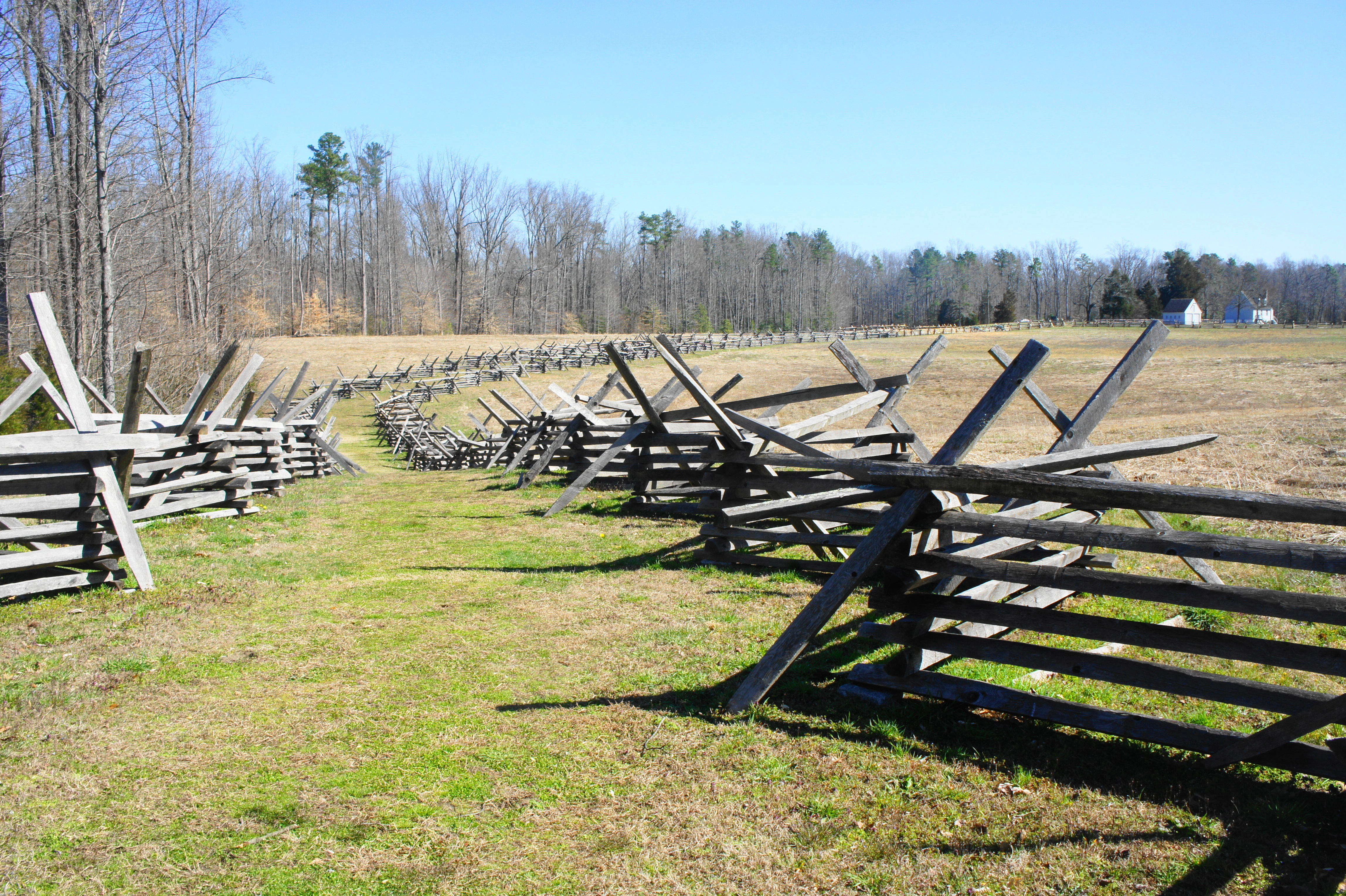
From the Wilcox monument, the Gaines’ Mill Trail bears southeast, leaving views of the creek behind and heading back toward the trailhead. At about 0.9 miles, the path abruptly reemerges from the woods, returning to the open fields of Turkey Hill. The hike is not over, however: at the next fork, bear right and follow the grassy path—between two sets of snake rail fence—to the Battlefield Overlook.

The overlook is somewhat underwhelming, with scattered foliage partly obscuring views across the fields to the west. (Note: The extreme right of Longstreet’s division barreled up this hillside during the evening assault.) There is an interesting panel, however, on the use of survey balloons during the battle, the only time during the Civil War that the two sides used aerial reconnaissance at the same time.

Heading back east on the trail, follow the grassy tread back toward the Watt House, staying straight at both trail forks. At the second junction, two artillery pieces mark the location of two guns operated by Union Capt. Stephen H. Weed’s artillery batteries during the battle.
Weed’s men would be forced to abandon the artillery as they—and the rest of Porter’s forces—retreated during the evening of June 27. Even in defeat, however, Porter’s 5th Corps achieved its purpose: covering the retreat of the Union Army as it moved south toward the James River. The Battle of Gaines’ Mill was celebrated as a Confederate victory in the South, but it came at a steep price of around 9,000 men killed and wounded.
The trail ends shortly after merging with a gravel road that cuts across Turkey Hill. The loop clocks in at about 1.3 miles (including the two spurs), roughly a 1-1 ½ hour hike across one of the Civil War’s bloodiest battlefields.
[1] Stephen W. Sears, To the Gates of Richmond: The Peninsula Campaign (New York: Ticknor & Fields, 1992), 211.
[2] Sears, To the Gates of Richmond, 240.

Pingback: Malvern Hill Trail (Richmond National Battlefield Park, VA) | Live and Let Hike
Pingback: Peninsula Campaign Driving Tour – Part 2 | Live and Let Hike
Pingback: Top 10 Hikes in 2018 | Live and Let Hike