
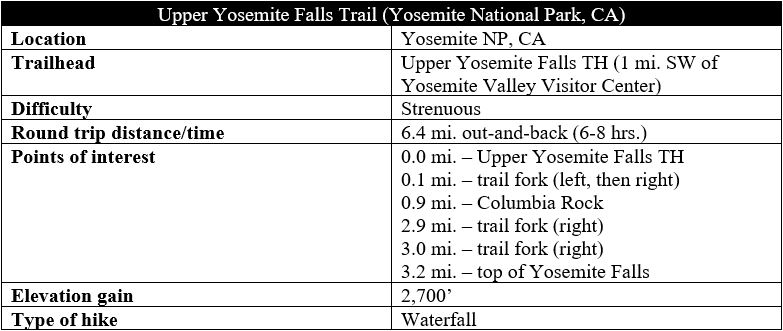
At 2,425 feet, Yosemite Falls is the tallest waterfall in North America* and an iconic destination in California’s Yosemite National Park. The entire height from base to crest can be tackled via the very strenuous Upper Yosemite Falls Trail, one of the most challenging day hikes in the park. Hikers who tackle the relentless switchbacks and 2,700 feet in elevation gain are rewarded with outstanding vistas of Yosemite Valley, as well as views of Yosemite Creek as it flows over the rim of towering granite cliffs, beginning its two-step drop to the valley below. The difficulty of this hike should not be underestimated: aside from the arduous elevation gain, the rocky traverse is often slippery as loose sand and the spray of the falls make sturdy hiking boots a must. (*Note: There is some dispute over this. Some surveys record Colonial Creek Falls in Washington State at 2,568 feet, and there are some minor, seasonal spills in Hawaii and British Columbia that technically are taller than Yosemite Falls.)
Highlights
- Satisfaction of having climbed the entire height of North America’s tallest waterfall
- Fantastic views of Upper Yosemite Falls and Yosemite Valley
Lowlights
- Brutal ascent and even more difficult descent as sandy, slippery rocks produce ample opportunities for twisted ankles
- Surprisingly crowded for such a strenuous hike
- Somewhat obscured views of the falls from the top

The hike
Figuring out where the Upper Yosemite Falls Trail starts can be a challenge on its own. While shuttle stop #6 offers access to Lower Yosemite Falls along Northside Drive, the route to Upper Yosemite Falls actually begins more than a half-mile farther west. The best option is to get off the free park shuttle at stop #7 (Camp 4) or park in the Lodge Day-use parking next to Yosemite Valley Lodge. (Note: Starting at Lower Yosemite Falls is possible but requires a half-mile hike along paved paths to reach the Upper Falls Trailhead.)
The hike begins at Camp 4, the famed climbers’ hangout, where there is a small sign indicating the way (northwest) to Upper Yosemite Falls. Walking across the campground and into the mixed conifer forest leads to a junction with the Valley Loop Trail, where hikers should bear left, then stay right at the subsequent turn less than a minute later. Here a sign indicates that it is 3.4 miles to the top of Yosemite Falls. This is not quite right (it’s about 3.1 miles from this point, according to my track), but it gives hikers a marker: only 3 miles to the top isn’t so bad, right?

Think again. Between here and the top are dozens of rocky switchbacks and relentless steps covering 2,700 miles in elevation gain, or around 900 feet per mile. The climb is no joke, and the switchbacks begin right away. The first section is nicely shaded by conifers and live oaks, with the first relatively unobstructed views not really encountered until 6/10 mile, when hikers can peer down at Yosemite Valley and the Merced River. Across the valley to the south are (from west to east) Cathedral Spires, Glacier Point, and Half Dome, the latter visible only after climbing more switchbacks when the trail finally gains an angle looking east.
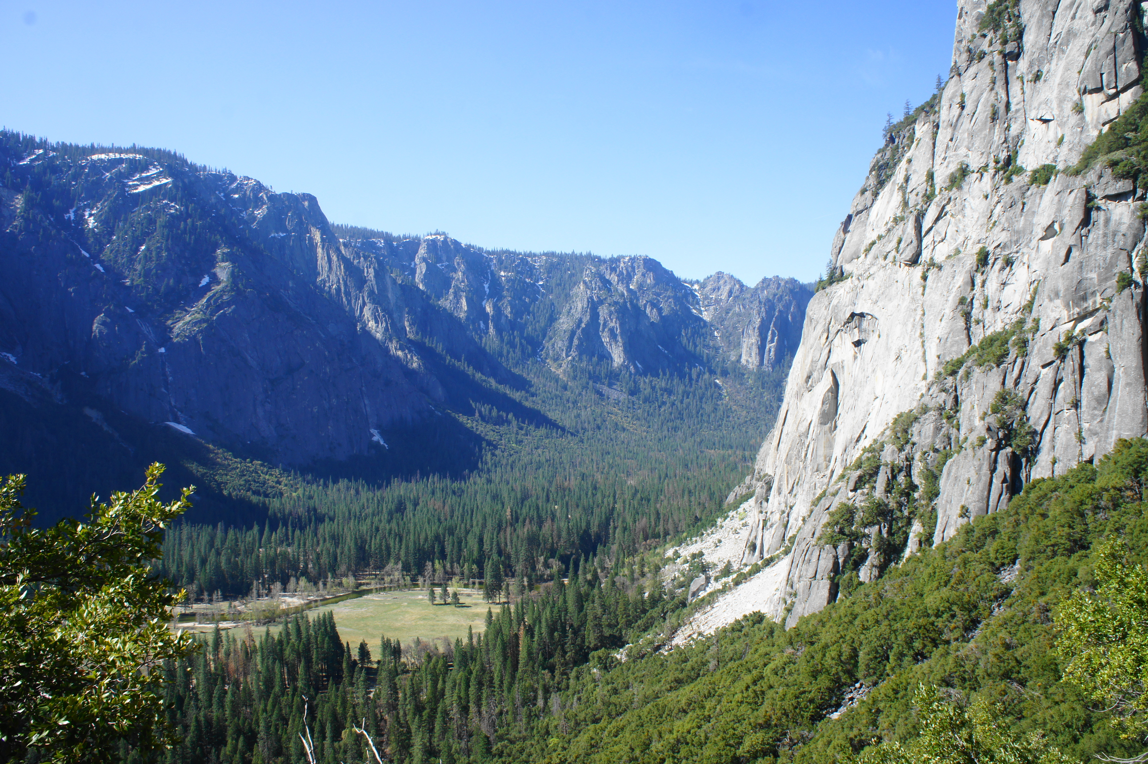
At 9/10 mile, after about 1,000 feet in elevation gain, hikers reach Columbia Rock, a small, railed viewpoint that is the turnaround point for a significant proportion of hikers. From here one can see up the valley to Half Dome, Tenaya Canyon, and the Little Yosemite Valley area, with higher granite peaks beyond.

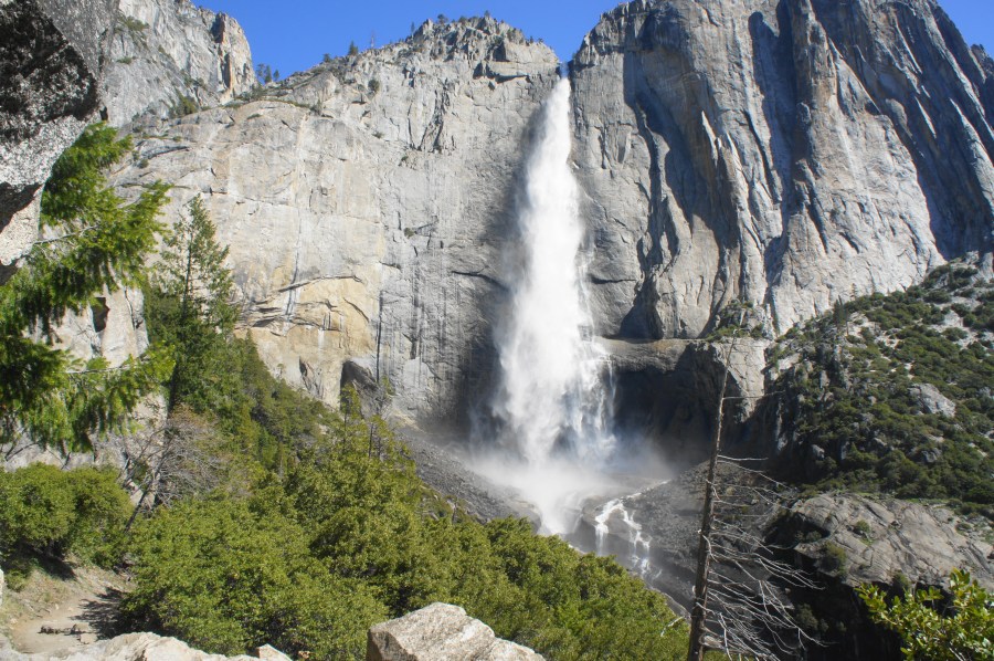
Beyond Columbia Rock, the trail continues to climb up sandy slopes for about 1/10 mile before it mercifully levels off for about a half mile. Bearing northeast along the base of granite walls, the Upper Yosemite Falls Trail even descends briefly in a couple places, reaching the hike’s first views of Upper Yosemite Falls at 1.25 miles. Here the spectacular waterfall (at least in spring and early summer) free-falls 1,430 feet, then tumbles down a set of cascades and culminates with a lower drop of 320 feet. Many hikers, content with what is perhaps the hike’s best view, turn around here, sparing themselves the remaining, brutal ascent.

The aforementioned ascent begins in earnest at around 1.45 miles, winding its way up toward a crack in the northern wall of Yosemite Valley, between the falls and Eagle Tower (7,290’). The switchbacks in this section are particularly slow-going, as the sandy (and often wet) steps demand patience and careful footing. Many hikers will need a rest at every few turns amid the relentless climb. A pair of excellent views of Yosemite Falls offer nice places to stop for a snack, after which the trail rounds a corner into the side drainage, leaving the falls obscured from view.

Yosemite Falls from the ascent 
Another angle


Now returning to near-full sun, the Upper Yosemite Falls Trail ascends the notch and, finally, around 2.8 miles, begins to briefly level off. Following a small drainage on the right, the hike crosses it at 2.9 miles and the route forks. Heading left leads to Eagle Peak (7,779’) and then Yosemite Creek Trailhead, while the more popular track bears right toward the top of the falls and Yosemite Point (6,410’).
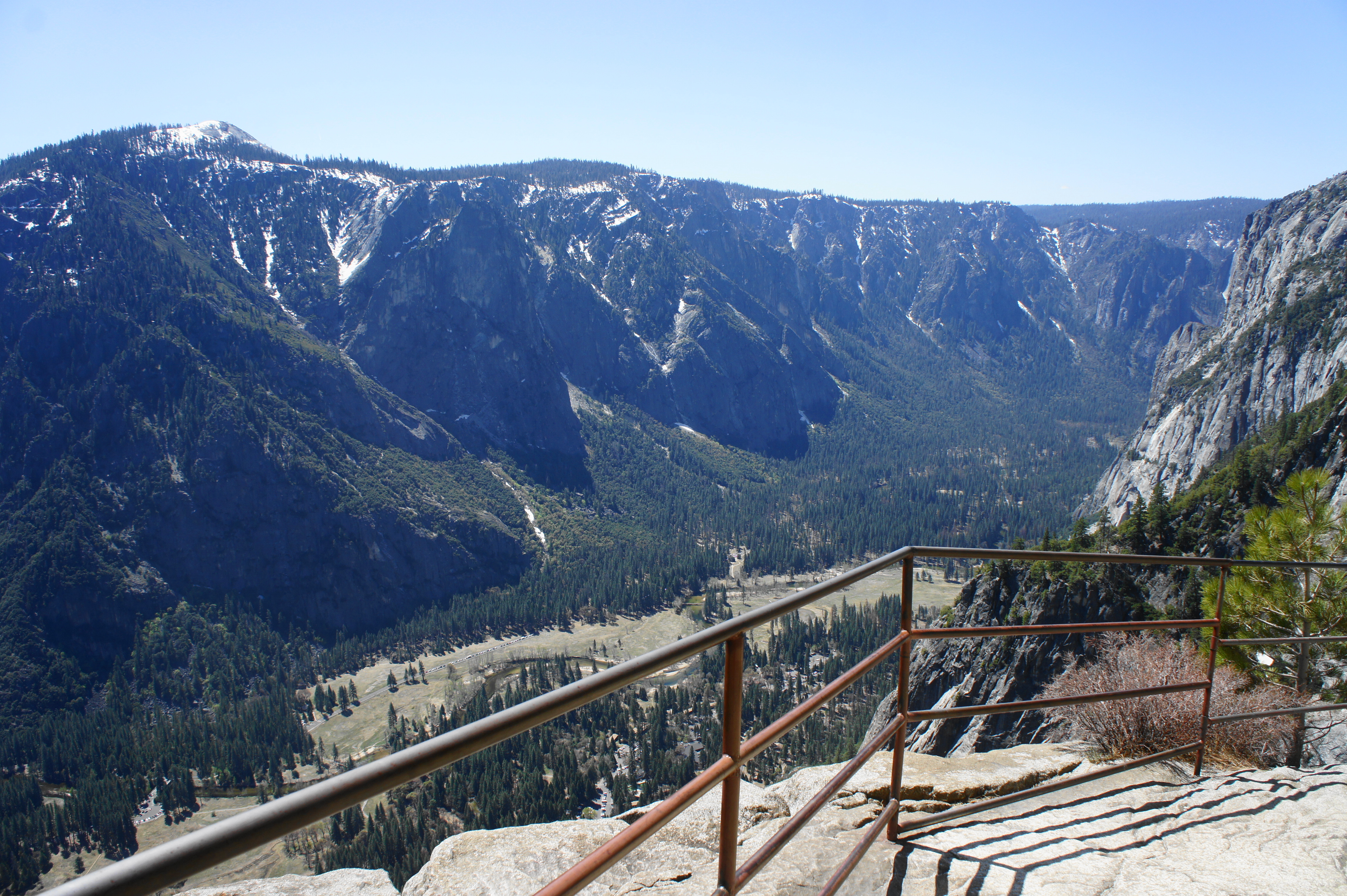
The next stretch can be confusing to follow, but footsteps generally lead east-southeast toward the cliff’s edge, with a second junction reached at around 3 miles. Stay right, descending through a narrow notch between granite outcrops, then come out to a rocky expanse with panoramic views of Yosemite Valley. This is the most popular place for hikers to stop for a snack or lunch break and admire the vistas.


View from top of Yosemite Falls 
Stony descent to end of the hike


The trail is not yet done, however. Follow the signs indicating the way to the top of Upper Yosemite Falls, and a narrow path leads over the lip of the granite surface and down stony stairs, equipped with metal railings to assist with the partially exposed descent. The trail ends at a small platform situated on a ledge overlooking the flow of Yosemite Falls.
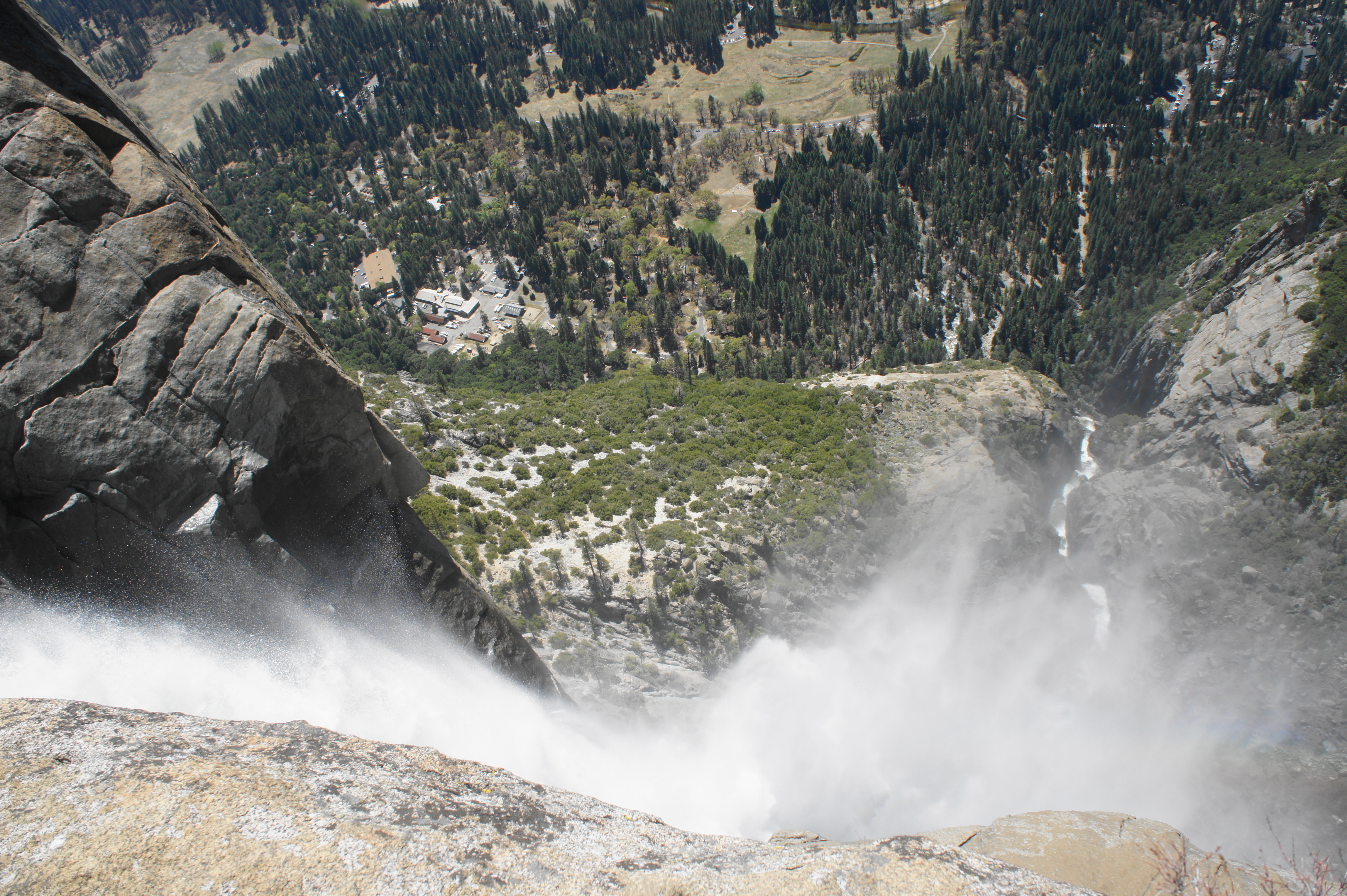
It is somewhat difficult and requires an awkward angle to see the lip of the falls, and Lower Yosemite Falls is obscured by the mist and cliffs below. However, this windy spot offers the satisfaction of being able to look down the entire length of North America’s tallest waterfall.
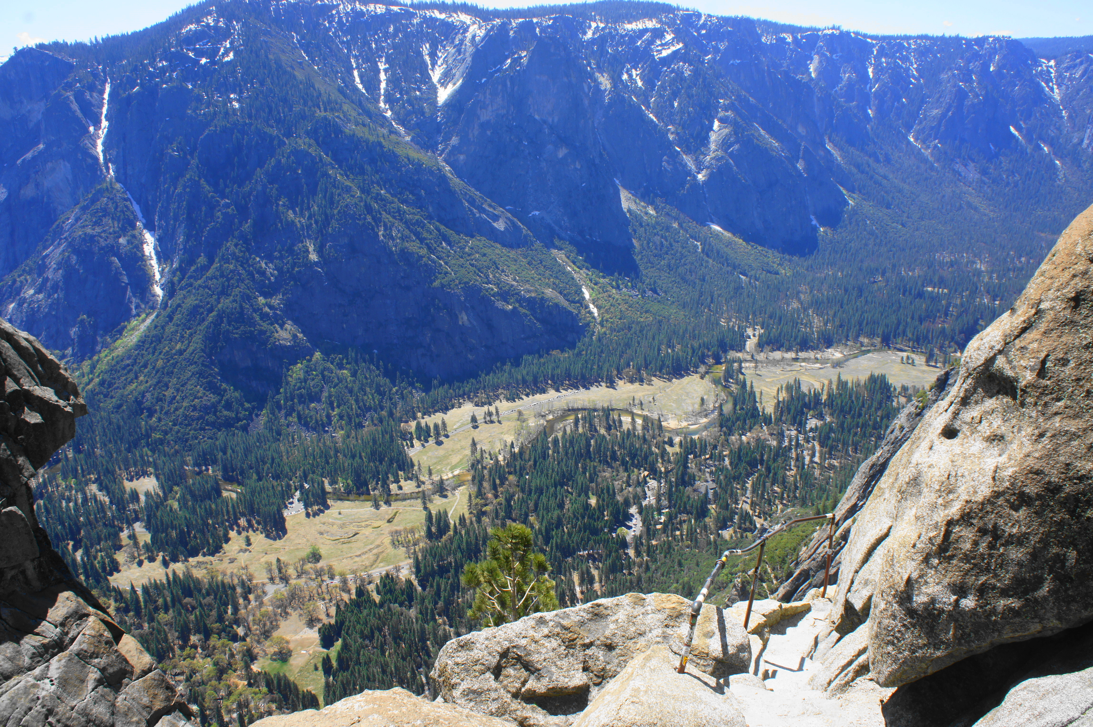
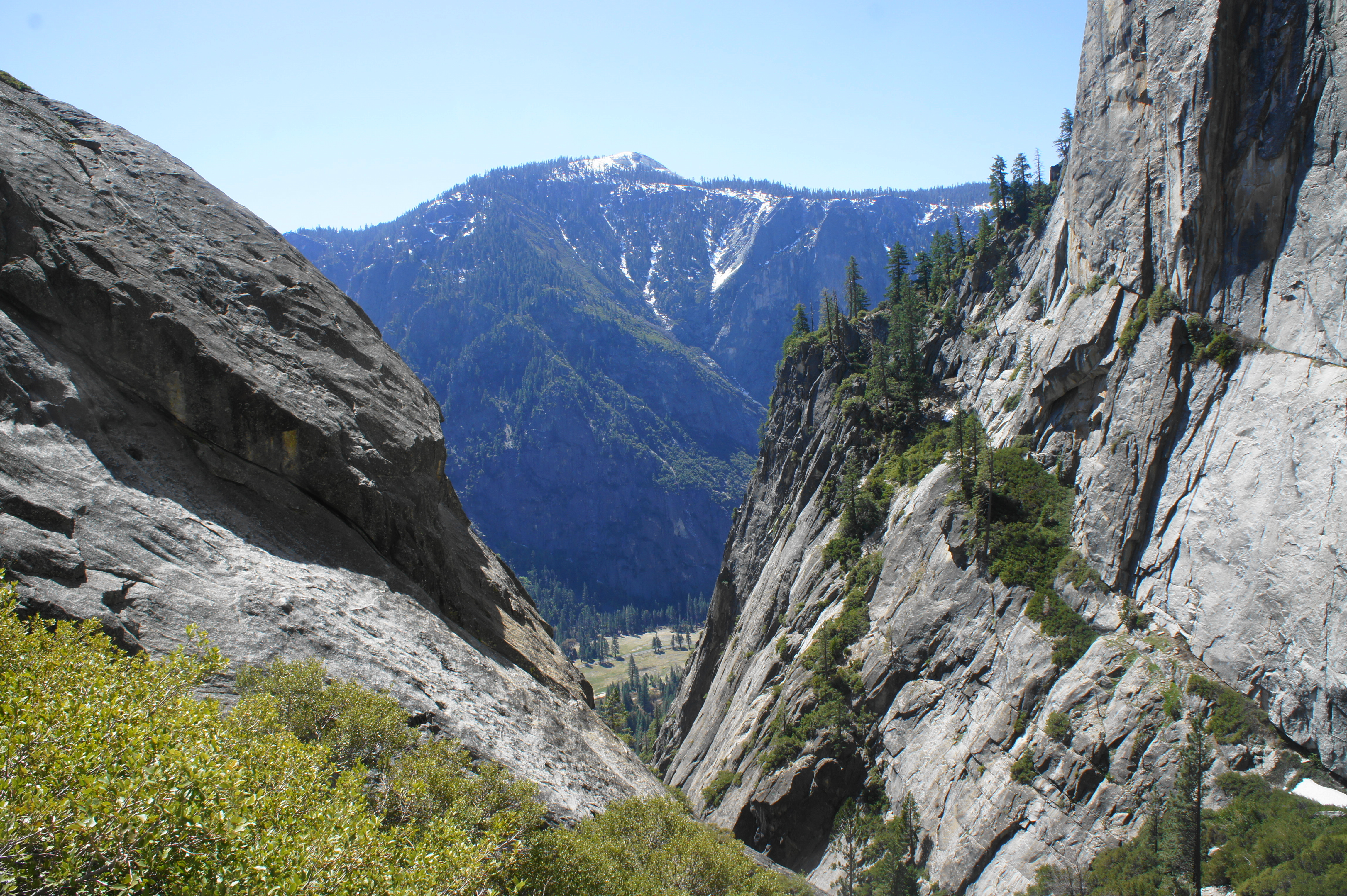
Heading back up the stairs, hikers can explore the surrounding outcrops for views upstream from Yosemite Falls, as well as different vistas of Yosemite Valley. Visitors can see southeast beyond Half Dome toward Mount Starr King (9,092’) and other peaks of the High Sierras.

Once ready, return the way you came, back to the junctions and creek crossing, then brace yourself for a slow and not-so-fun descent. Heading downhill is arguably more difficult than the ascent, with lots of opportunities for slipping on the slick rocks. Take your time, stopping for breaks, as you descend the three miles and 2,700 feet back to the start of the hike.

This is an all-day affair: most hikers will be too tired to do another big hike on the same day as Upper Yosemite Falls.

Pingback: Top 10 Hikes in 2021 | Live and Let Hike
Pingback: Washburn Trail (Yosemite National Park, CA) | Live and Let Hike