
Generally less frequented than nearby Yosemite or Sequoia & Kings Canyon National Park, the John Muir Wilderness spans 650,000 acres of mostly unblemished mountain terrain in the heart of California’s Sierra Nevada. The region is dotted with hundreds of alpine and subalpine lakes, each of which shimmers in the midday sun, with many sporting excellent views of surrounding craggy peaks. One such destination—a hidden gem in the John Muir Wilderness between Mammoth Lakes to the north and Lake Thomas Edison and Mono Creek to the south—is Mott Lake, which is set in a terrific basin below the Silver Divide. The lake is scarcely-visited but within two miles of the long-distance John Muir Trail (JMT), making for a worthy detour for JMT through-hikers if you find yourself with 2-3 hours to spare. Along the way, hikers will cross the scenic North Fork of Mono Creek and ascend wildflower-strewn slopes to the majestic lake.

The hike
Part of Mott Lake’s charm is its remoteness, situated in a rarely-travelled drainage in the John Muir Wilderness just south of the Silver Divide. The nearest road access is more than 10 miles away at Vermilion Valley Resort (VVR), on the western side of Lake Thomas Edison. Mott Lake is reachable as an overnight backpacking trip from VVR, but most visitors will likely be John Muir Trail (JMT) through-hikers, heading north or south on their 220-plus mile journey between Yosemite and Mount Whitney. (Note: The relevant section of the JMT is described here.)
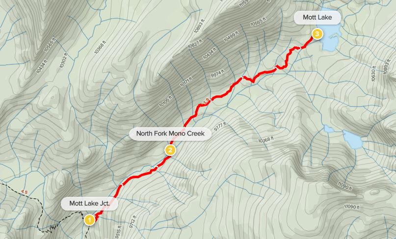
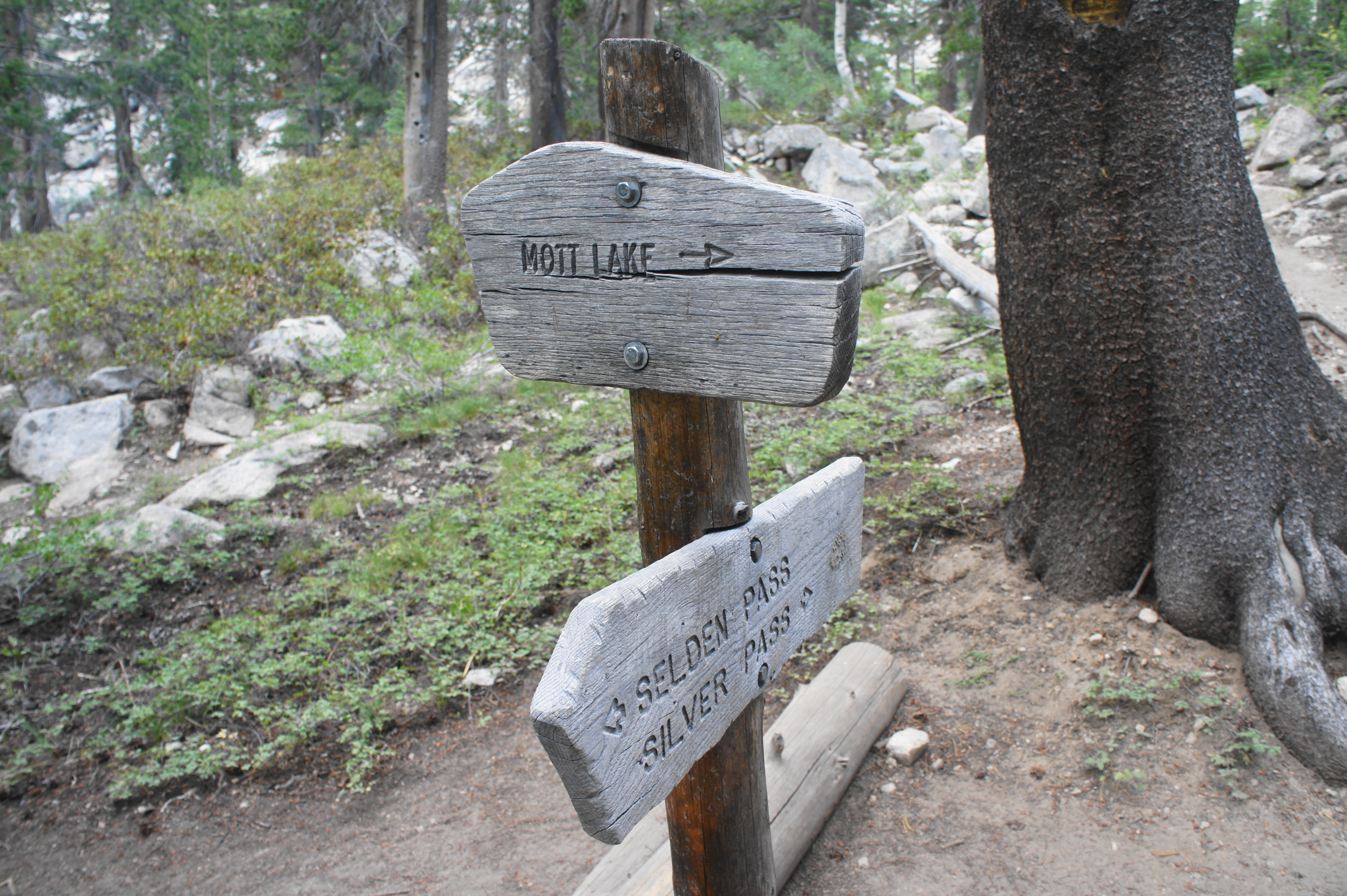
The Mott Lake Trail begins at a junction with the JMT, about three miles north of the bridge over Mono Creek and 3.5 miles south of Silver Pass. Follow the sign as the immediately fainter spur trail parts with the well-trafficked JMT and then ascends a steep pitch lined with thick conifers. Despite its low traffic, the route is relatively easy to follow, and the grade eases briefly after about 1/3-1/2 mile.
Here the trail passes an open granite slab with the North Fork of Mono Creek flowing through it. This gentle stream eventually connects with the main Mono Creek drainage and empties into Lake Thomas Edison. Then continue on a steady ascent alongside the creek before finally crossing it at a point about ¾ mile from the start.

Now on the left side of the stream, the trail rises through muddy, buggy terrain, but the wildflowers—which erupt here in a rainbow of colors—make the mucky ascent enjoyable. Eventually the Mott Lake Trail rises to a point overlooking a scenic meadow down to the right, with views back toward the lower canyon.


After reentering the woods, the trail becomes a little harder to follow as it bounds up a series of stony shelves, with occasional cairns and footprints guiding the way. The steadily-climbing trail finally levels off after about 1.8 miles and then approaches Mott Lake, where there a few previously-disturbed campsites.

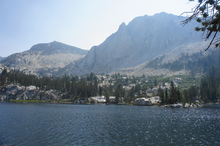
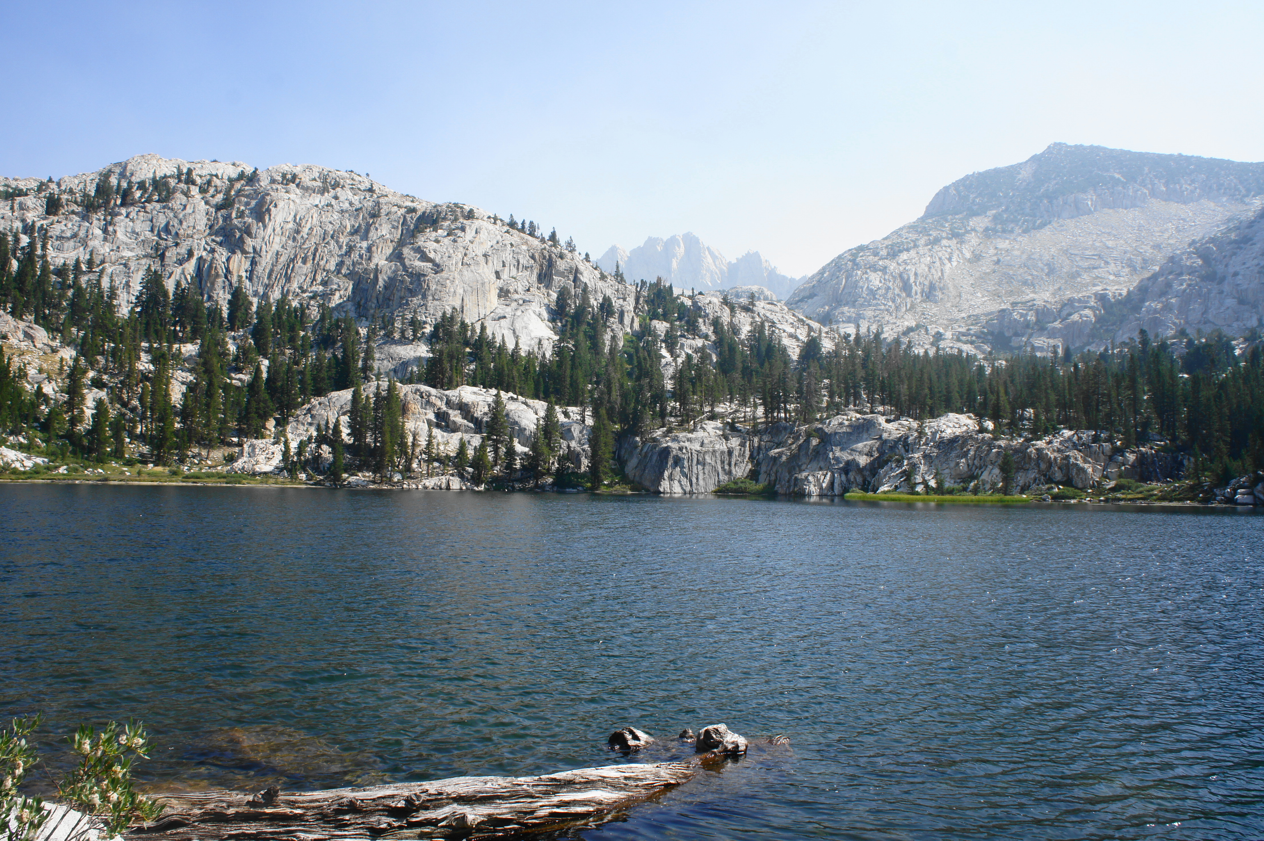
The views from Mott Lake’s western shores are stupendous, with the landscape dominated by a sheer granite pitch off to the southeast. The views extend northward toward Red and White Mountain (12,850’) and Mount Crocker (12,457’), with tree-line ridges obscuring an alpine landscape beyond that harbors two more higher lakes (Bighorn and Ross Finch Lakes). (Note: These lakes can be reached via some off-trail scrambling.) To the north lies Mount Isaak Walton (12,099’), a prominent peak also visible from the JMT near Silver Pass.
The waters here at Mott Lake are clear and serene, with opportunities—like much of the area—for some decent trout fishing. Although the official trail ends here, spur paths lead partway around the lake, and ambitious hikers can explore farther upstream toward the headwaters of the North Fork.

After enjoying the lake, return the way you came for 1.9 miles back to the JMT.

Thanks for sharing this nice post Andrew.
Mott Lake looks really nice and especially all the peaks that surround it.
Pingback: Top 10 Hikes in 2021 | Live and Let Hike
It is ROSY Finch lake, named after the bird Rosy Finch. You wrote “Ross Finch lake”.
Pingback: Five Lakes Trail (Granite Chief Wilderness, CA) | Live and Let Hike
Good description of the lake, hike and surrounding terrain. It’s been MANY years since I hiked it, but there is one thing you left out. As the mountains have not likely changed in the years since my ascent, it is probably still true that … you better be in shape to attempt this 2-mile hike. It is STEEP and the elevation unforgiving (as in no oxygen). I thought I was going to die. And I was in decent shape (former fire fighter familiar with the Sierra Nevada). Whew. But the views, after a long rest, were spectacular. And the lake unbelievably clear, clean and cold. Best of luck to all who attempt to visit.