
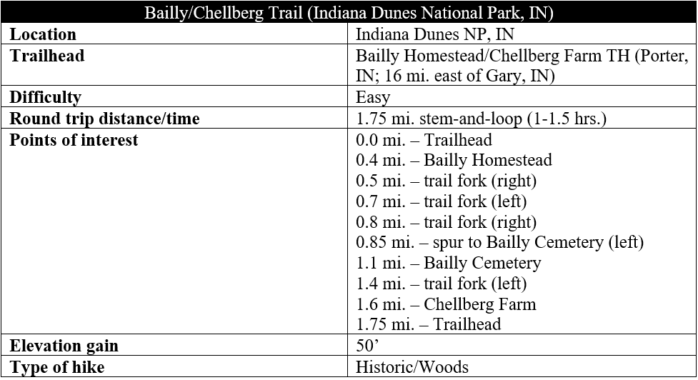
A prominent French Canadian fur trader, Joseph Bailly settled in the Indiana Dunes area in the early 19th century, establishing a trading post in 1822 near present-day Porter, Indiana. Decades later, Swedish immigrants Anders and Johanna Kjellberg purchased 80 acres of land on the other side of a small forest, establishing a small family farm and tapping the sugar maples to make maple syrup. Today, both the Bailly Homestead and Chellberg Farms still stand, incorporated into Indiana Dunes National Park and easily combined on a short, easy loop hike. In addition to the historic sites, the Bailly/Chellberg Trail traverses a fine section of deciduous forest and includes a spur to the impressive Bailly Cemetery. This easy walk covers about 1.75 miles and is a family-friendly hike in the Porter area.
The hike
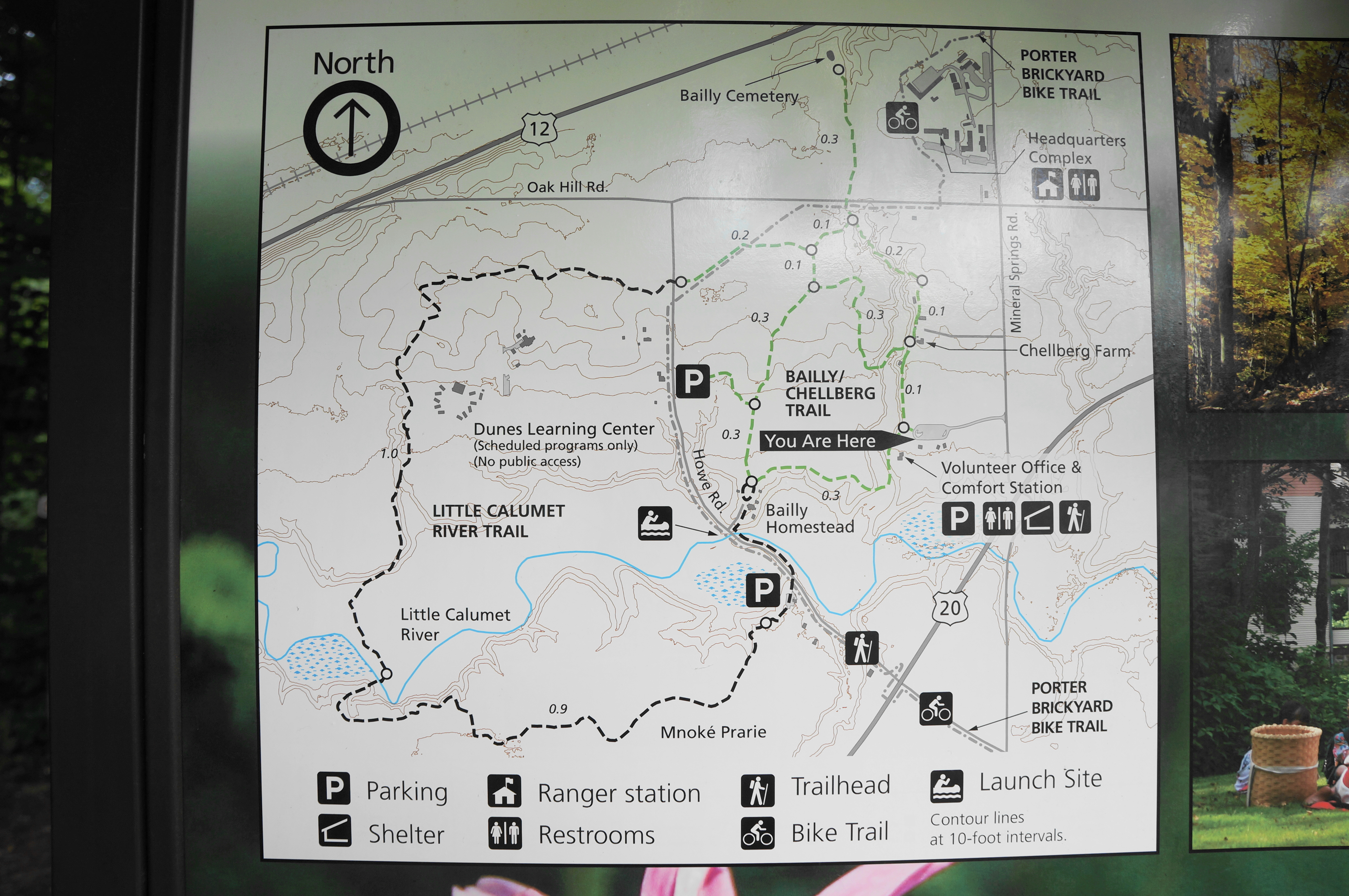
There are several options for connecting to the Bailly/Chellberg Trail loop, but the starting point that makes the most sense is the trailhead off Mineral Springs Road, just north of U.S. Route 20 and south of Oak Hill Road and the Park Headquarters area. (Note: The trailhead is marked “Little Calumet River Trail” on Google Maps.) There are several picnic verandas here, as well as a volunteer information station, which has limited hours.
The trail begins at the east end of the parking lot, marked by a large information board/map. (Note: The trail maps for Indiana Dunes are quite good; they are also available on the NPS app.) Immediately the partly-mulched path enters a dense forest of new growth and splits in two. Head left first, starting the loop and pursuing it in a clockwise direction.
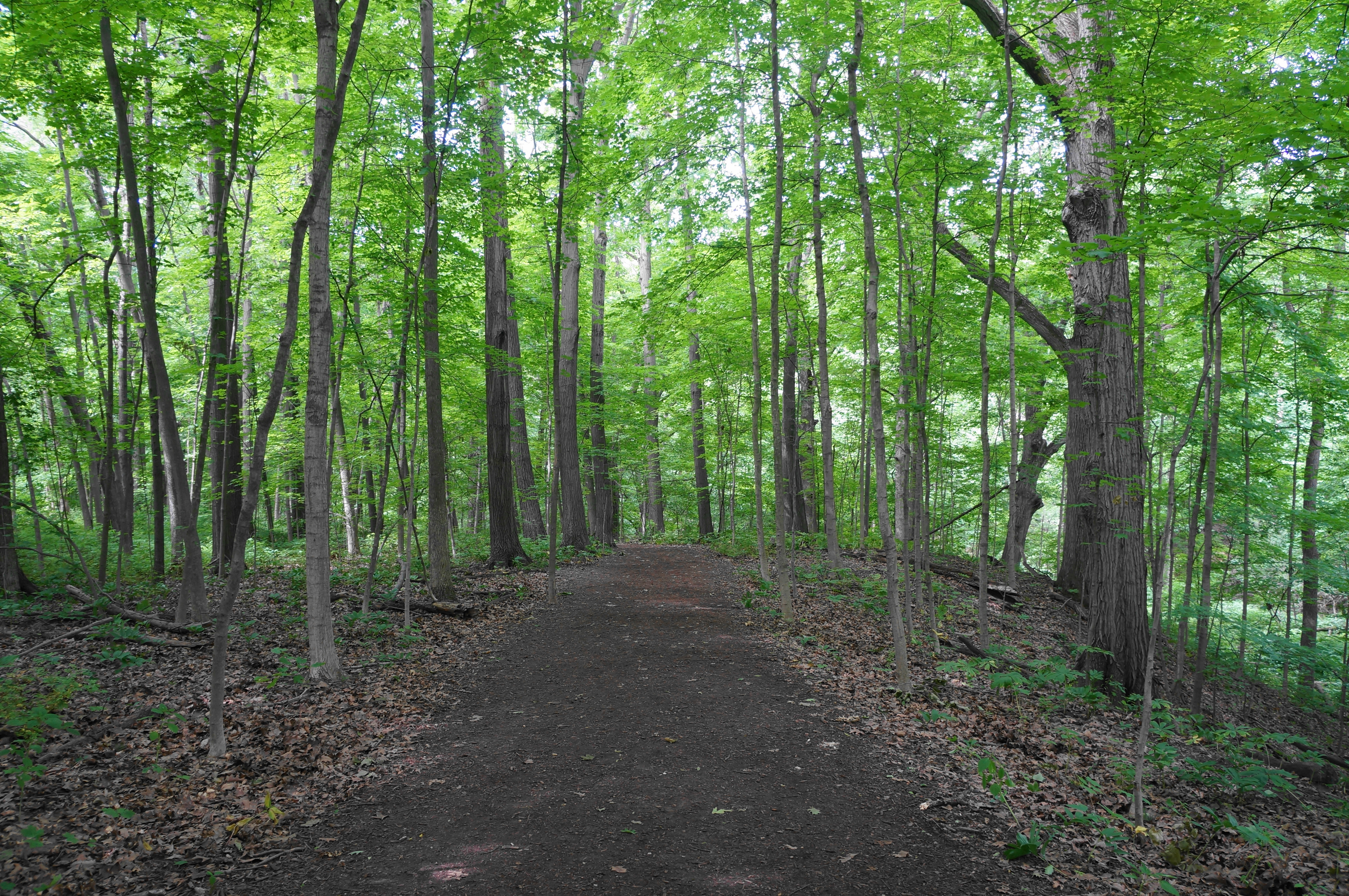
Here the wide track treads southwest, above the banks of an unnamed creek bed on the right. Soon the trail drops to cross the (often dry) drainage, then climbs briefly back to return to the flat basin. Head west through a sea of maples, oaks, and other deciduous varieties and emerge at around 3/10 mile at an open field. Look to the left for a historic plaque marking this area as a National Historic Landmark. Ahead, to the south, is the Bailly Homestead, a series of renovated structures dedicated to telling the story of Joseph Bailly, a fur trader who had unusually good relations with the Native Americans in the area. The main house on the property is an example of vernacular architecture: a building constructed without professional guidance and occurring outside any particular architectural tradition, usually made from local materials.


Visitors can sometimes tour the property and house, although, as of summer 2022, the Bailly homestead was closed for renovations. To continue the loop, backtrack across the open field, heading for the northwest corner of the property. Here you will find a singletrack and sign for “historic cemetery.” Proceed this way, returning to the thick woods.

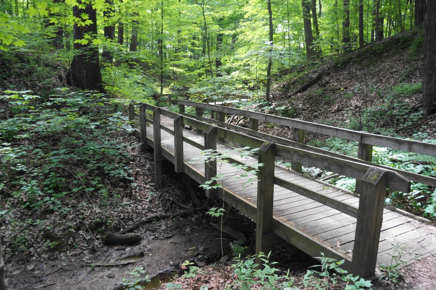
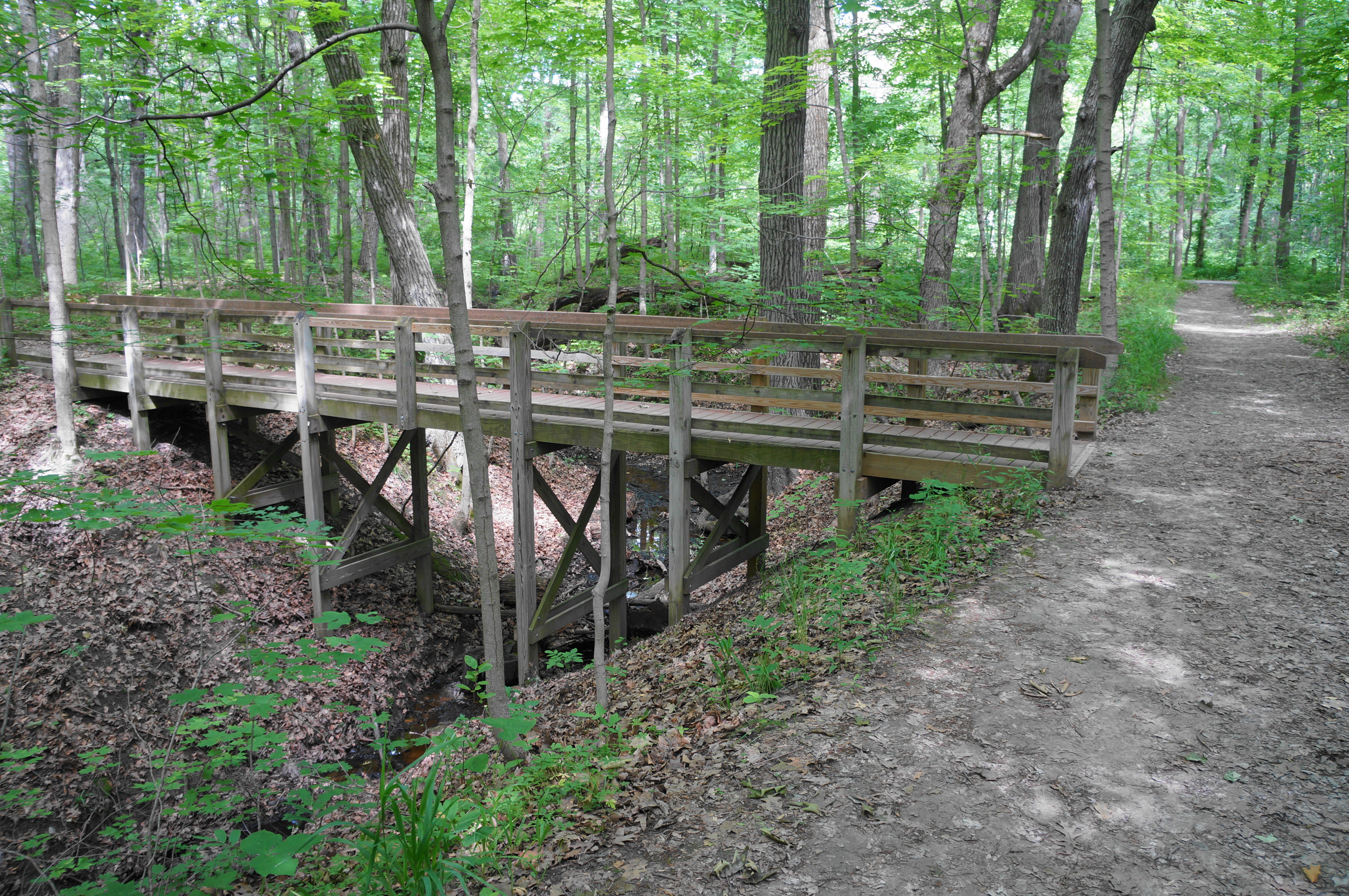
Pass a trail fork at ½ mile, continuing right and climbing a mild incline, followed by a row of four impressive, spindly oak trees. Come to a second fork at 7/10 mile, bear left, then stay right at a third junction minutes later. From here the Bailly/Chellberg Trail descends to clear the same drainage from before, crossing a bridge over a surprisingly deep-cut gully.

Here hikers can bear right to continue the loop, but it is worth a ½-mile detour to visit the nearby Bailly Cemetery. To take this spur, heading left at the junction just after the bridge, staying straight as the trail intersects with the Porter Brickyard Bike Trail and crosses Oak Hill Road. Once across, the hum of Highway 12 grows stronger, but the walk is peaceful nonetheless as it snakes through the dense woods. At 1.1 miles, after a short uphill, the spur ends at Bailly Cemetery, a brick-encased plot situated on a bluff that once overlooked Lake Michigan. The entire Bailly family is buried here.


Visitors can encircle the cemetery or simply turn around, returning across Oak Hill Road. Once back at the bridge, stay straight, keeping the drainage cut on your right. Soon there is a wooden staircase down, descending into the woody couloir. In this pretty section, the route traverses three bridges, followed by another wooden staircase—this time going up. Pass a huge birch tree on the right, cross another bridge, and then climb up to another open field.


Here there is an unmarked junction. Bear right, entering the Chellberg Farm and approaching the various historic structures from the north. The Swedish Kjellberg—or Chellberg—family travelled to the United States in 1863 and eventually purchased this land and operated a working farm. The property was passed down two generations before being sold to the National Park Service in 1972. Today, visitors can tour the farm, which has a handful of live animals.

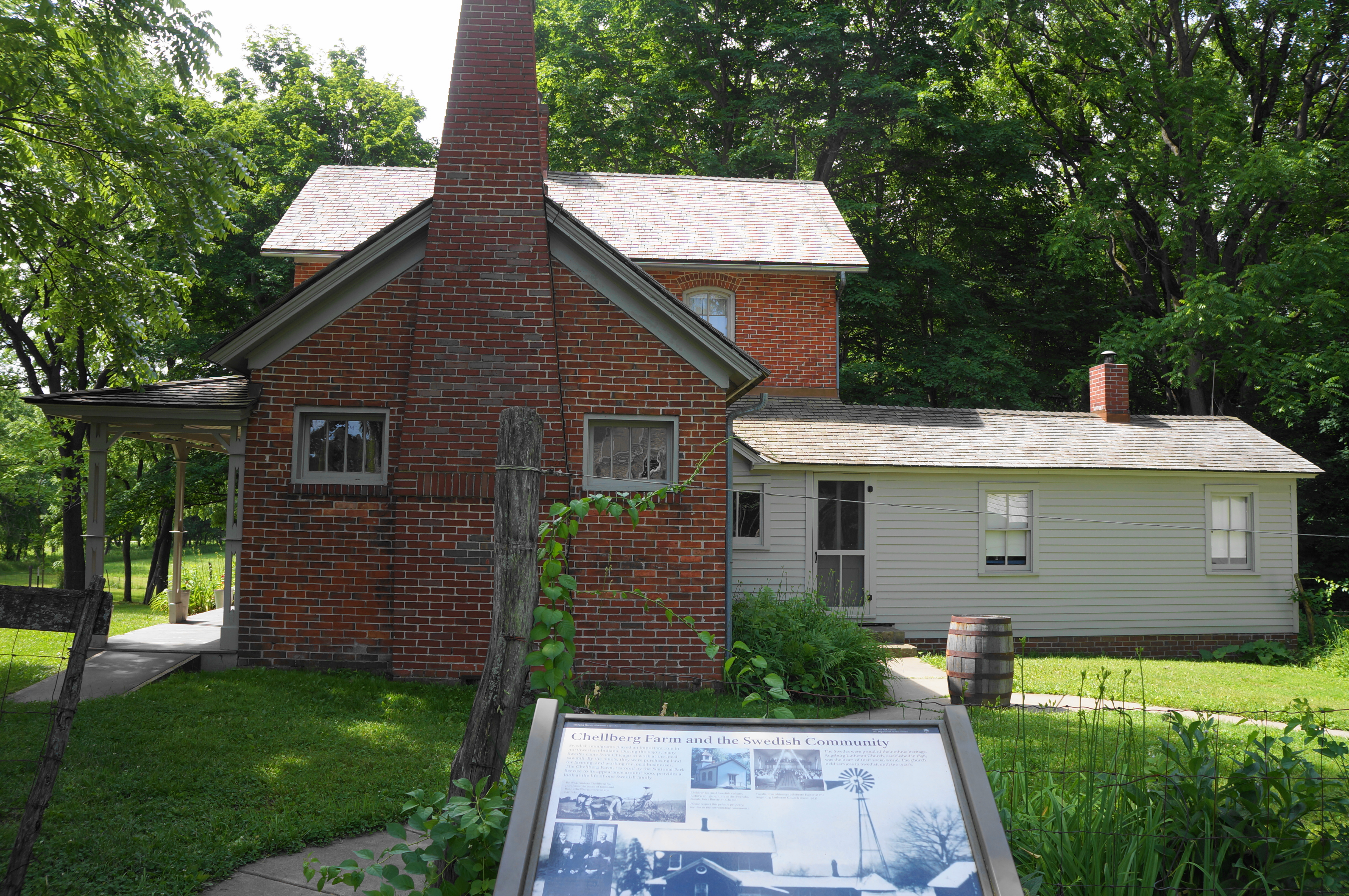
Follow the path between the farm and the woods as it bears southward, approaching the very interesting maple house on the right, a small structure where the Chellbergs stored equipment for tapping the sugar maples of the area, producing delicious maple syrup.
From here, it is a short walk along the wide path back to the initial junction, where hikers can bear left and step out onto the parking lot again. All told, this 1.75-mile stem-and-loop hike should take hikers between 1-2 hours to complete.

Awesome trail!