Hahns Peak Trail (Routt National Forest, CO)

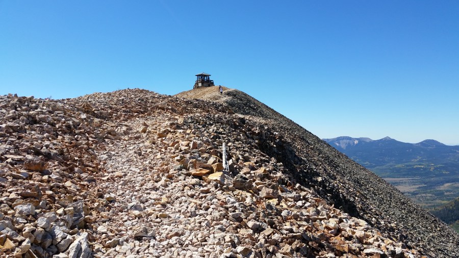
Situated roughly a 30-mile drive from Steamboat Springs, Hahns Peak (10,839’) is one of Colorado’s most enticing summits. While not one of the state’s tallest mountains—or even the highest in the Elkhead Mountains—the volcanic peak nonetheless stands out for its prominence: a lonely, rocky bald visible from miles away, the guardian of the grassy valley …

Continue reading Hahns Peak Trail (Routt National Forest, CO)

Fish Creek Falls Loop (Routt National Forest, CO)

At 284 feet, Fish Creek Falls is the second-highest waterfall in Colorado and is easily accessible from popular resort town Steamboat Springs. For visitors with an hour or less, a 0.8-mile loop provides a look at the falls from two different vantage points: a high overlook with views from a distance and a look up …

Continue reading Fish Creek Falls Loop (Routt National Forest, CO)

Trading Post Trail (Red Rocks Park, CO)

Rising abruptly from the dry prairielands at the base of Colorado’s Front Range, the ruddy sandstone outcrops at Red Rocks Park are a popular destination in the Denver area. A short drive from the bustling metropolis, Red Rocks feels in some ways like an urban spectacle: the park is most well-known, after all, for its …

Continue reading Trading Post Trail (Red Rocks Park, CO)

Bruin Bluff Trail Loop (Lair o’ the Bear Park, CO)

Gaining 180 feet in elevation, the Bruin Bluff Trail is a slightly more difficult alternative to the Bear Creek Trail in Lair o’ the Bear Park, roughly five miles west of Morrison, Colorado. Climbing in and out of mostly spruce forests, the meandering path provides views of a sun-soaked valley in Colorado’s Front Range, including …

Continue reading Bruin Bluff Trail Loop (Lair o’ the Bear Park, CO)

Bear Creek Trail to Corwina Park (Lair o’ the Bear Park, CO)

One of the easiest mountain hikes in the Denver area, the Bear Creek Trail offers a family-friendly adventure through Lair o’ the Bear Park, which is roughly halfway between Morrison and Evergreen, Colorado. Heading west from the Lair o’ the Bear parking area, the hard-packed trail hugs a gently-flowing stream before entering shady Bear Creek …

Continue reading Bear Creek Trail to Corwina Park (Lair o’ the Bear Park, CO)

Monarch Pass, CO

Monarch Pass, situated between Gunnison and Poncha Springs along Colorado’s Route 50, crosses the Continental Divide at 11,312 feet, offering spectacular vistas of central Colorado’s Sawatch Range, which boasts many of the state’s highest peaks. Including the Monarch Mountain ski area, the area around the pass is a launching-off point for skiers, hikers, and bikers, …

Continue reading Monarch Pass, CO

High Bridge Trail (Box Canyon Park, CO)

The High Bridge Trail is a more strenuous alternative to the lower Box Canyon Falls Trail, climbing 200 feet to a suspension bridge that spans Box Canyon and offers views northeast to Ouray, Colorado. On sunny summer days and weekends, it’s also likely to be jam-packed with visitors, making an early morning or late afternoon …

Continue reading High Bridge Trail (Box Canyon Park, CO)

Box Canyon Falls Trail (Box Canyon Park, CO)

Billed as “Ouray’s slot canyon,” Box Canyon Waterfall and Park is one of the most popular destinations in the area. Situated just outside southwest Colorado’s “Switzerland of America,” Box Canyon Falls is concealed in a dark, narrow gorge accessed only by a steel-reinforced walkway and staircase. Visit in spring, or after heavy rain, to see …

Continue reading Box Canyon Falls Trail (Box Canyon Park, CO)

“Million Dollar Highway” – Ouray to Silverton

Southwest Colorado’s “Million Dollar Highway”—also known, less memorably, as Route 550—traverses some of the most breathtaking scenery in the state. With sharp curves, steep grades, and a conspicuous lack of guard rails, it is also one of the most harrowing drives in the Rockies. The 23-mile section connecting Ouray to Silverton features historic ghost towns, …

Continue reading “Million Dollar Highway” – Ouray to Silverton

Sutton Mine Trail (Uncompahgre National Forest, CO)

The Sutton Mine Trail—situated just south of Ouray, Colorado—rewards hearty hikers who brave the initial, gut-wrenching ascent with spectacular views of Ouray, Uncompahgre Gorge, Bear Creek Falls, and Abrams Mountain. Ending at an abandoned mine, this 2.2-mile jaunt packs nearly 700 feet in elevation gain into the first half-mile before leveling out atop a rocky …

Continue reading Sutton Mine Trail (Uncompahgre National Forest, CO)