

At 284 feet, Fish Creek Falls is the second-highest waterfall in Colorado and is easily accessible from popular resort town Steamboat Springs. For visitors with an hour or less, a 0.8-mile loop provides a look at the falls from two different vantage points: a high overlook with views from a distance and a look up at the mighty cascade from a bridge passing over Fish Creek. The trip to the overlook is wheelchair-accessible, while the descent to the bridge involves deep, wooden steps. (Note: See my post from December 29, 2018 for a description of a longer hike to Upper Fish Creek Falls.)


The hike
From Steamboat Springs, drive along Fish Creek Falls Road east to its terminus, three miles from town and within the boundaries of Routt National Forest. Park at the upper parking area at Fish Creek Recreation Area if possible—if spaces are unavailable, backtrack to the lower parking area and follow the paved path that adds 2/10 mile to the hike.
From the upper parking area, find your way to the main map/kiosk, and then bear right on the paved track heading northeast amid brushy, sun-lit terrain. (Note: A second, unpaved path drops steeply from the parking area; save this for later—this is the return route.) This is the Overlook Trail. The wide, level path passes Gambel oak and shrub oak varieties, complete with a yellow shine as the seasons turn in September. The rock-studded slopes ahead mark the western fringe of the Park Range, illuminated in the fall by patches of golden-colored aspens.
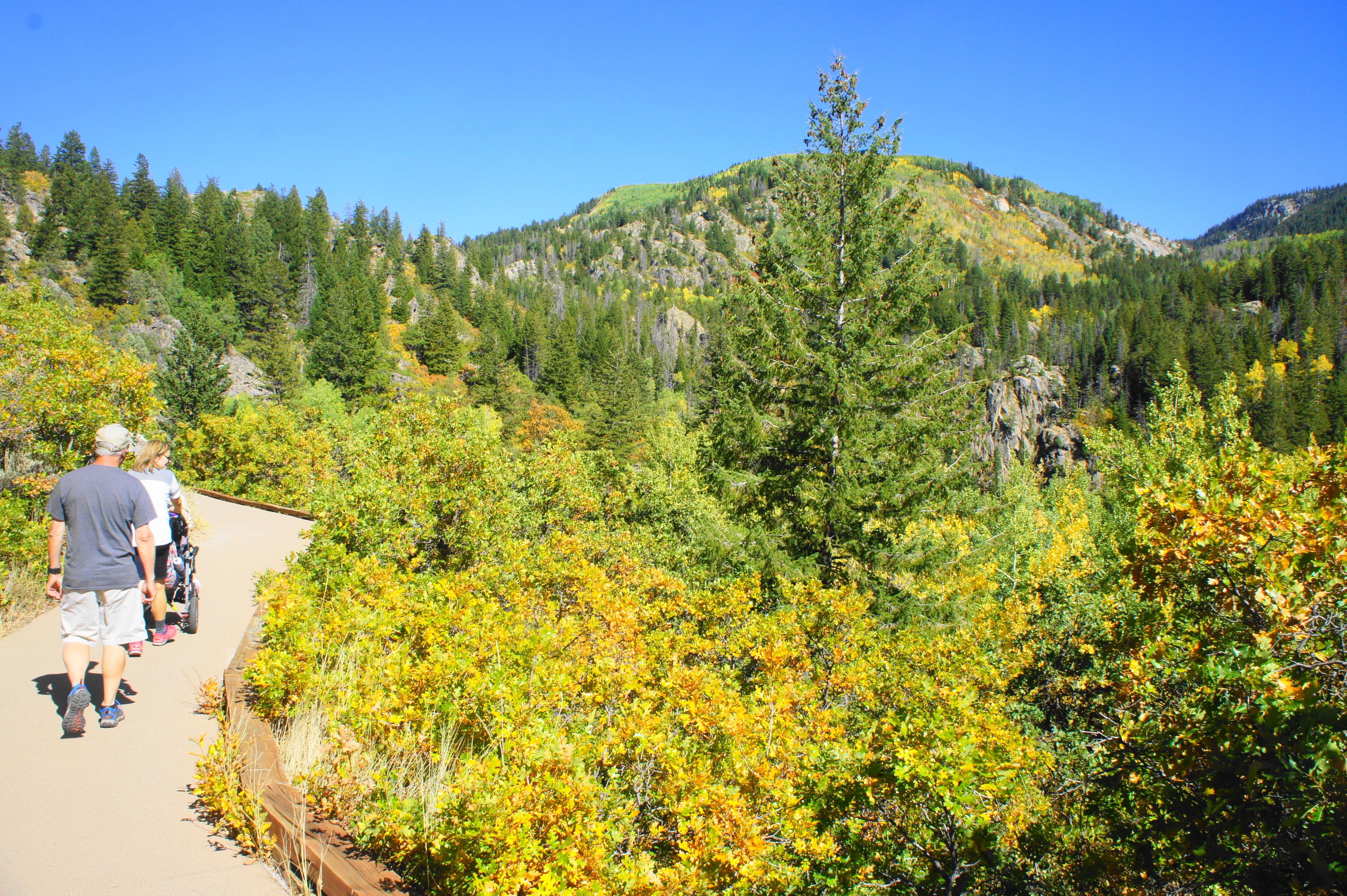
Rounding a brushy gully, the Overlook Trail reaches a junction with the Picnic Trail at roughly 2/10 mile. Continuing left on the Overlook Trail, the level path, now heading south, approaches the first of two viewpoints. This one offers a fine view of the Fish Creek drainage as it bears westward toward Steamboat Springs, but views of the falls remain relatively obscured.

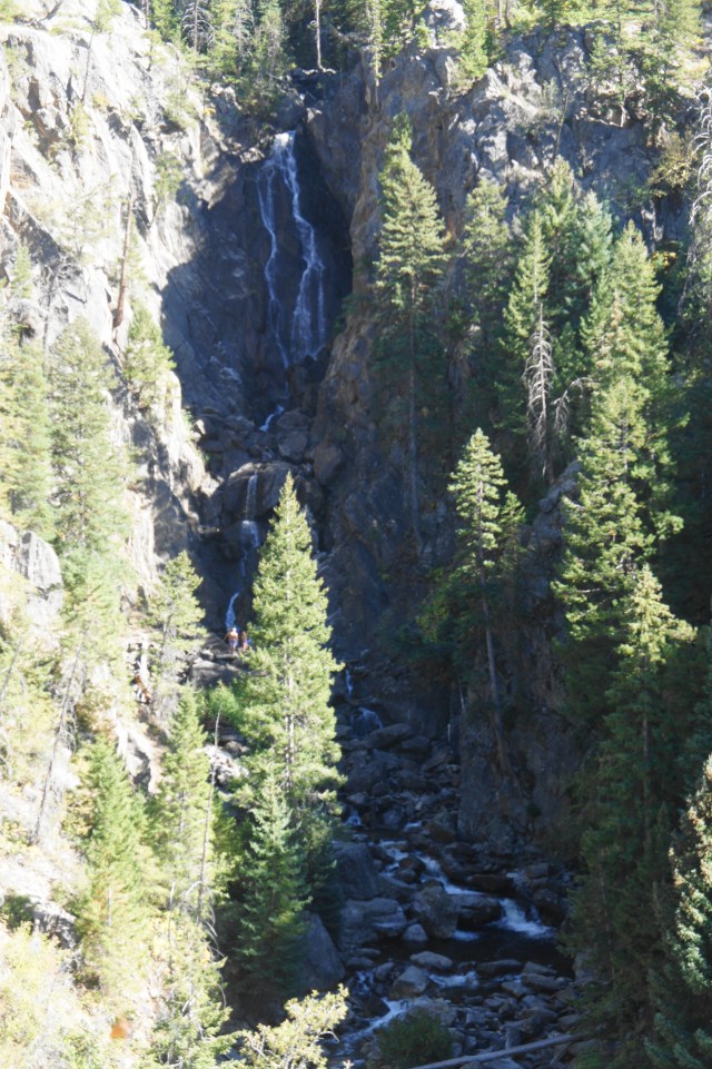
Continue on the trail as it cuts east, reaching the main overlook at about the ¼ mile mark. From here the 284-foot Fish Creek Falls unfolds below, tucked away in a shady canyon. Fish Creek Falls is situated at the end of a glaciated hanging valley—a valley above a valley—amid a jumble of dark metamorphic rocks, such as schist and gneiss. The rushing waters are usually at their highest flow in late spring to early summer, but they continue to drop a relatively significant volume into the fall. A wayside sign provides context on the falls, and a covered bench offers a place to sit to take in the view.
After the overlook, it is time to see the falls from a different angle—down below from the wooden bridge at its base. To do so, backtrack to the junction with the Picnic Trail and bear left on the paved but steadily descending path. Hugging the hillside, the trail cuts sharply right after a brief view of the canyon below and then gradually descends to the well-shaded picnic area. Beyond the picnic tables, the path gets steeper and rougher, eventually emptying onto the wider and well-worn Fish Creek National Recreation Trail. (Note: The Picnic Trail is wheelchair-accessible with assistance, but the Fish Creek NRT is dirt and the ascent can be challenging.)

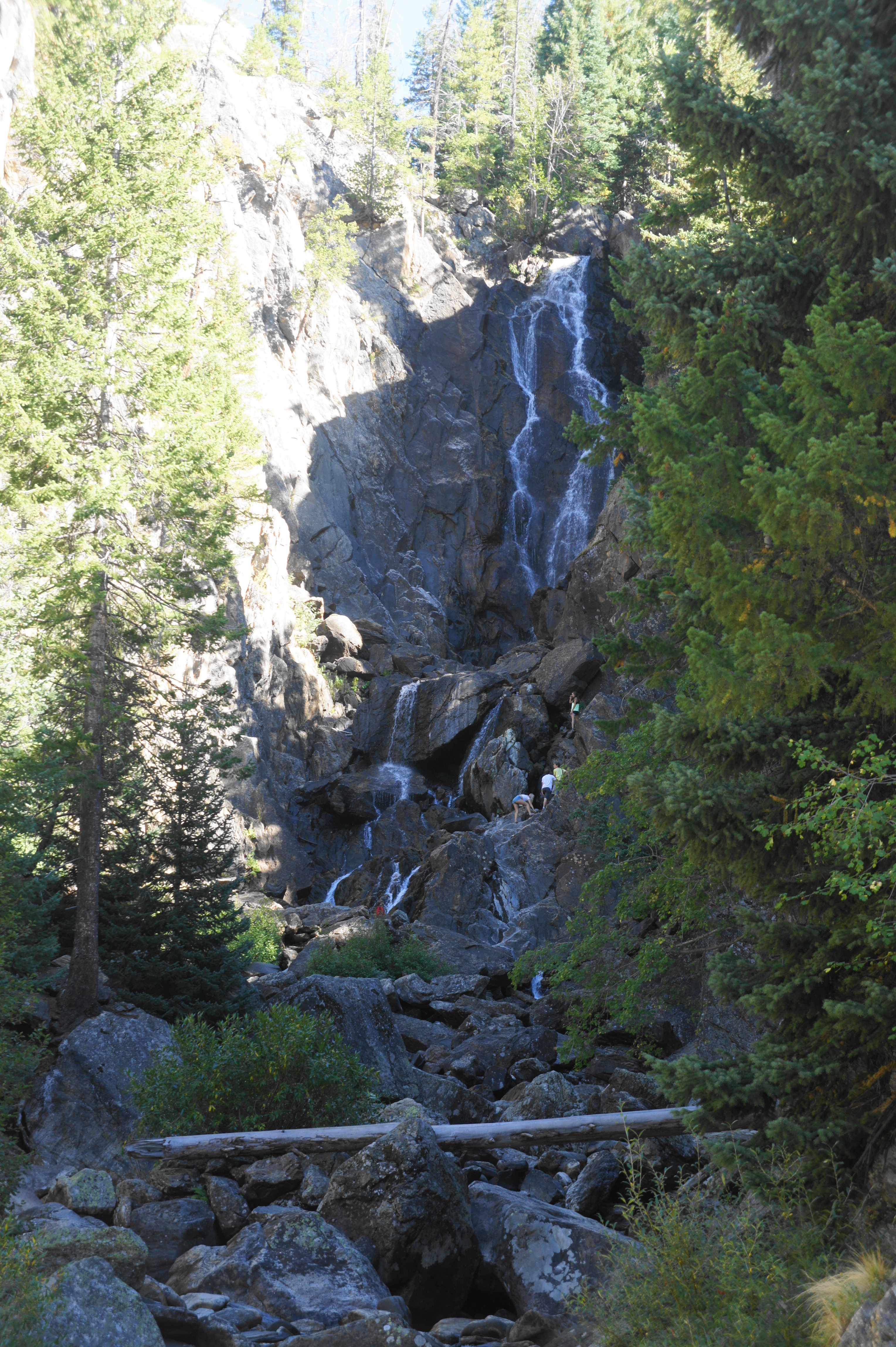
To reach the base of the falls, descend the Fish Creek Trail as it drops steeply down a set of wooden steps, drawing nearer to the roar of the cascades. It is about a 5-minute walk from here to the bridge, positioned in a narrow cleft between rock faces. Because the waterfall is tucked away in the canyon above, it is only possible to view Fish Creek Falls from the far west side of the bridge—leaving limited room among the crowds that are sure to be there on a busy summer day. (Note: Adventurous travelers can try to rock hop to the actual base of the falls, but this involves some a steep drop from the bridge and a potentially dangerous traverse during high water. It is also possible to continue past the bridge for around two miles to reach Upper Fish Creek Falls, a smaller but charming waterfall in a hanging valley above.)

From the bridge, return the way you came, this time climbing up the steep stairs to the tune of 100 feet in elevation gain. Continue straight past the entry of the Picnic Trail on the right; the parking area is a short walk away. Once back at the parking lot, you will have completed the full circuit.
If parked at the upper lot, allot around 30 minutes to an hour for this relatively easy hike. (Note: Add another 10 minutes round trip if parked further down the road at the lower lot.)

Pingback: Upper Fish Creek Falls (Routt National Forest, CO) | Live and Let Hike
Pingback: Top 10 Hikes in 2018 | Live and Let Hike