
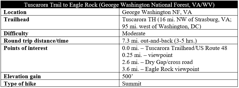
The 252-mile Tuscarora Trail—the shorter cousin to the much-vaunted, nearby Appalachian Trail—weaves through tree-studded mountain ranges and rolling farmlands spanning four different Mid-Atlantic states: Virginia, West Virginia, Maryland, and Pennsylvania. While completing the full length of the trail takes several weeks, day hikers can cover short sections along the trail. There are few better jaunts along the Tuscarora than the 3.6-mile out-and-back to Eagle Rock, where scintillating views of the Great North Mountain range and Shenandoah Valley make the moderately strenuous up-and-down of the access route worthwhile.

The hike
The two most common ways to access Eagle Rock are from the west, following the Tuscarora Trail as it straddles the Virginia-West Virginia border. The shortest option is to park at Dry Gap, along Capon Springs Road (Virginia SR 209; West Virginia CR 16), and climb 500 feet in a little over a mile to reach the viewpoint. The second, and longer, option—and the subject of this hike—begins further south and west at the point where US Route 48 crests Great North Mountain—also the state boundary. As you approach the ridgeline, look for a gravel road, blocked to traffic, off to the south; there is also a small brown “Tuscarora Trail” sign. Park along the shoulder here on the south side.
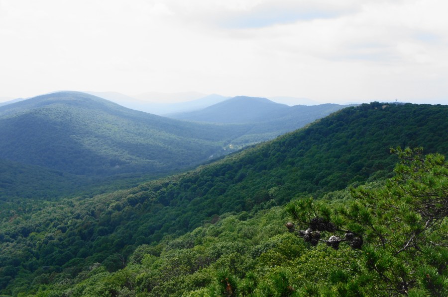
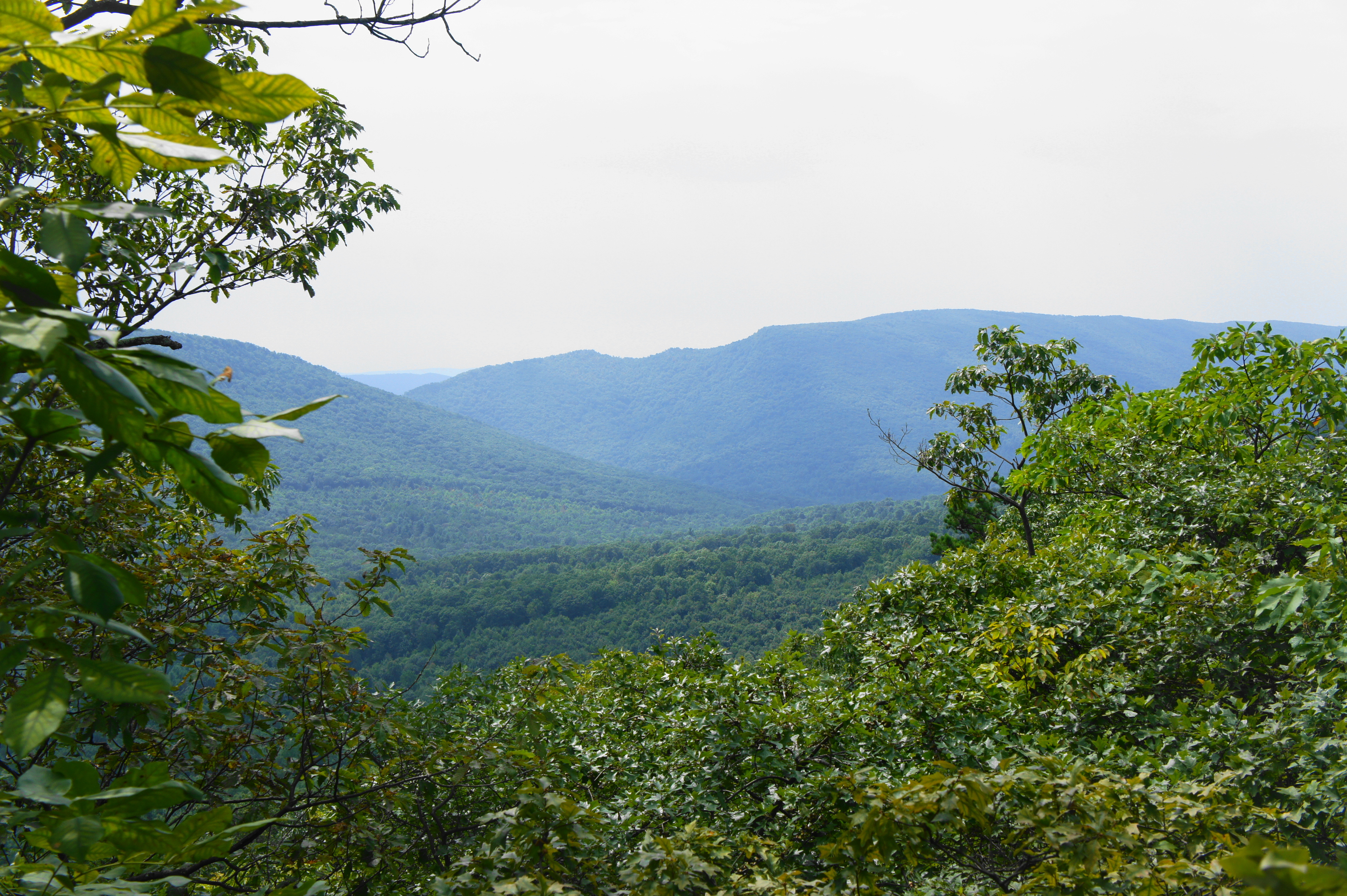
After parking, cross to the north side of the road (carefully—traffic here is going fast), where you will find a well-trodden path. This is the northbound Tuscarora Trail. Leaving the highway behind, the trail climbs rapidly before gradually easing, approaching a junction with an old road heading left at around 150 yards. Stay right amid the rocky terrain. Peeking over the ridgeline, a small spur heads off to the right at about ¼ mile, offering a window view to the south toward Paddy Gap and Paddy Mountain (3,013’), part of the broader Great North Mountain range.
The Tuscarora Trail continues northeast from here, flattening out considerably as the ridge narrows. A few minutes later, hikers can spot a gravel road off to the left—this is Forest Road 539 on the West Virginia side. Merging with an old roadbed from the left, the trail passes an established campsite at about 6/10 mile and then a communications relay tower at around 8/10 mile. Just beyond the tower, the path passes under a set of power lines, offering a brief glimpse of the Cold Springs Gap area below. An uphill at about 1.3 mile brings hikers to the base of a second, larger tower. From here, the trail begins a gradual but steady decline, shedding about 300 feet in the next 1.2 miles.

At 1.8 miles, stay right at the trail fork—the orange-blazed trail bearing left leads to the Hawk recreation area. (Note: This junction is less visible than it used to be because the Tuscarora Trail has been rerouted toward Eagle Rock rather than down to Hawk.) At about 2.3 miles, the footpath drops relatively steeply, ending the descent at a small parking area along the Capon Springs Road at Dry Gap. (Note: This is the start of the shorter version of the hike.)
Crossing to the other side of Capon Springs Road, the trail is much wider and well-defined. A small sign indicates that one is heading for Eagle Rock. Having lost 300 feet in elevation, the trail makes up for it again with a steady climb, wrapping around the north-facing side of Great North Mountain. The incline picks up around mile 3, and hikers reach a trail fork at 3.15 miles. Stay right, leading into a sharp uphill that marks the final approach. By 3.4 miles, the incline levels out again, and hikers can sense that the overlook is near. Finally, at about 3.6 miles, gaps in the trees begin to offer unobstructed views, and a set of rocky ledges—Eagle Rock—invite visitors to peer over the edge.
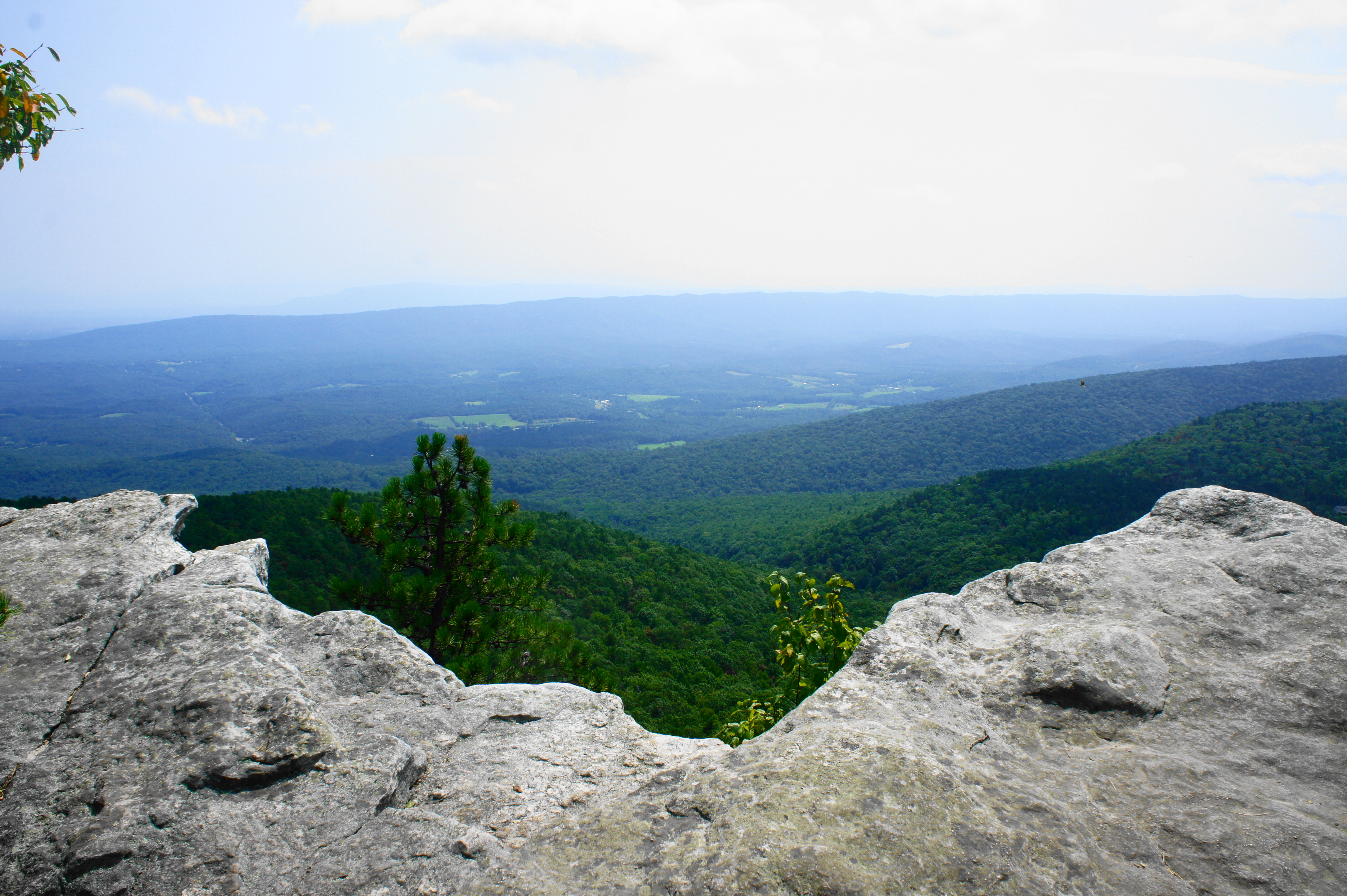
The vista at Eagle Rock, while not a 360 degree panorama, is one of the finest in the area. The best view is to the southwest, where two ridgelines—Paddy Mountain/Little Sluice Mountain and Great North Mountain—run parallel to one another for as far as the eye can see, while individual mountaintops dot the ridges, giving the terrain greater a scenic texture. The small bulge with a house on top of it in the foreground is, aptly named, Short Mountain (2,164’). Behind it is the higher Johnnies Knob (2,639’), while the stream in the gully below (seen in the distance) is Paddy Run, which leads into Vance’s Cove.

Over to the east, the green mountains give way to a broad valley bookended by Little North Mountain—beyond is the much broader Shenandoah Valley. On clear days, Massanutten Mountain and the Blue Ridge Mountains of Shenandoah National Park are visible on the horizon.

The viewpoint offers a single stone bench that makes for a great lunch spot. (Note: Eagle Rock’s relative obscurity means the summit has far less crowds than many others in the area.) The Tuscarora Trail continues northward from here, but day hikers will want to return the way they came, traversing the 3.6 miles back to the start.
Allot 3-5 hours, depending on pace, for the moderately strenuous round trip.


Pingback: Top 10 Hikes in 2018 | Live and Let Hike
Eagle rock is on private property!!! I know because I’m the owner. Please don’t trespass.
Signed,
The owner
What? Since when? A real tragedy if so.
Is there right of way for hikers? I’m not sure how Tuscarora Trail hikers get around it. Of course, hikers should always respect private property by staying on the trail. But shutting down the trail completely would be new and a real shame.