
The principal wonder of Natural Bridges National Monument in southeast Utah is this: nowhere else in North America—perhaps the world—can you see three of Earth’s largest natural bridges in one day’s hike. Yes, that’s natural bridges, not arches, mind you—the former are carved by continuously-flowing streams, while the latter rely on the erosional forces of wind, water, and freezing and thawing. Natural Bridges boasts the second and third largest natural bridges on the continent (surpassed only by Utah’s Rainbow Bridge), as well as an impressive array of archaeological sites from the ancestral Puebloans, better known by their Navajo name—Anasazi (though this title is discouraged). The loop hike described below hits the highlights, including the three bridges (Sipapu, Kachina, and Owachomo), a series of ruins and petroglyph panels, countless bends in two sinuous canyons (White and Armstrong), and a mesa-top hike affording views of the surrounding cliffsides.
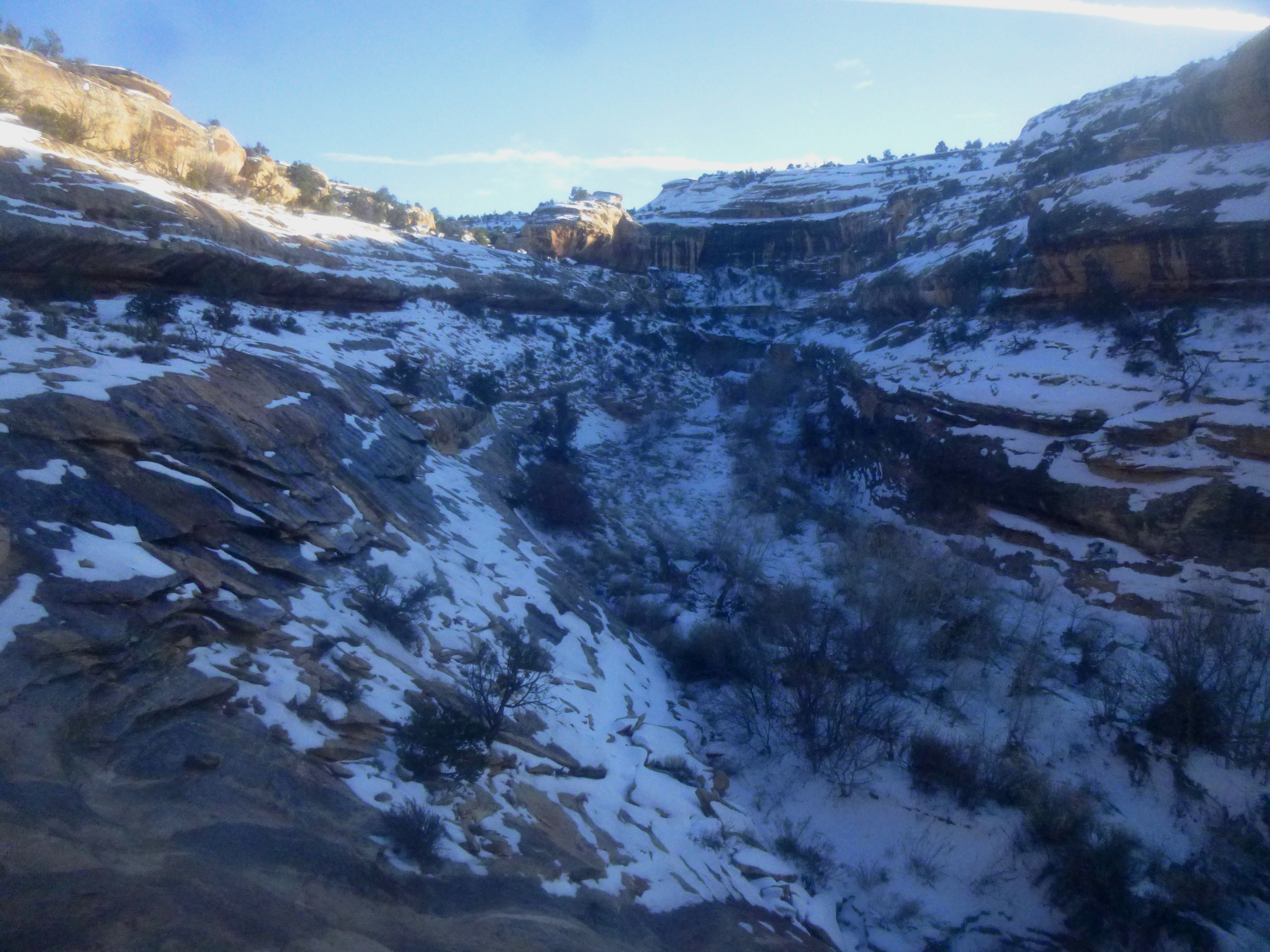
(Note: I completed the Natural Bridges Loop in early January, when there were roughly three inches of snow on the ground. Much of the hike—especially in White and Armstrong Canyons—required improvisation; following faint, snow-covered trails and footprints of other hikers; and inventive, icy creek crossings. Therefore, the following route description may not be entirely accurate under different conditions.)


The hike
(Note: The total distance for this loop hike—I have seen 8.2, 8.4, 8.6, 8.7, and 8.8 miles—remains rather ambiguous. The official Natural Bridges “Visitor Guide” distributed at the park pegs the loop trail at 8.6 miles/13.8 kilometers. However, trail signs—as well as the distances listed on the map on the same visitor brochure—point to 8.4 miles. The latter to me seemed to make the most sense, but it’s perhaps worth crosschecking if you bring along a GPS.)
Natural Bridges National Monument is a relatively small park, and the majority of visitors are content with spending 2-3 hours completing the 9-mile Bridge View Drive, snapping photos from the comfort of viewpoints along the canyon rim. Then they’re off…heading to Arches or Canyonlands or Monument Valley or Mesa Verde…
To get a true flavor of the bridges—and the canyons of Cedar Mesa sandstone from which they were formed—requires considerably more effort. Visitors with a half to full day should consider parking a car at one of the bridges and hiking to the rest: the 8.4-mile Loop Trail, comprising more than six miles of walking through White and Armstrong Canyons and two miles traversing the pinyon/juniper-covered mesa, is the best way to see the park. To pack in the most excitement with the least slog, park at either the Sipapu or the Owachomo Bridge turnoff and hike in a counterclockwise direction around the loop. Completed in this manner, the trail descends 500 feet to Sipapu Bridge (much better than a 500-foot climb), saving the ascent back to the canyon rim for Owachomo, where it is a reasonable 180-foot gain from the bridge to the road.
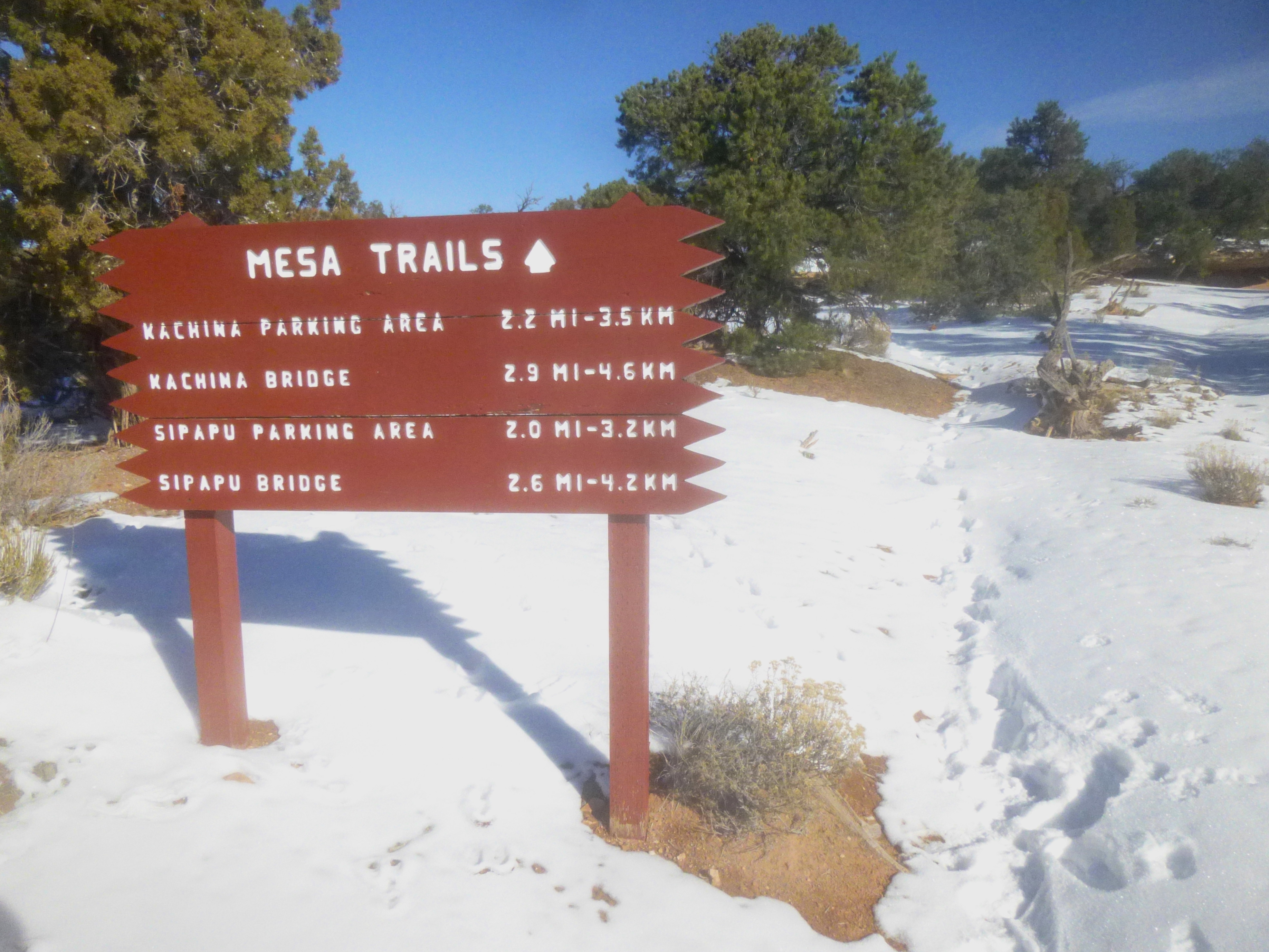
Furthermore, tackle the least interesting section—two miles on the Mesa Trail—first by parking at Owachomo Bridge, seven miles from the Natural Bridges Visitor Center along one-way Bridge View Drive. Elevation at the parking lot here, near the confluence of Tuwa and Armstrong Canyon, is roughly 6,100’.
Mesa Trail—Owachomo Bridge to Sipapu Bridge
From the Owachomo Bridge parking area, cross the street to the north end, where a large red sign indicates the start of the “Mesa Trails” system. It is two miles across relatively level terrain from here to the Sipapu Bridge parking area.
The easily-discernable path (even in snow) begins by cutting straight through pinyon-juniper communities before quickly reaching the first obstacle of the hike, a slickrock ledge surmounted with the assistance of a sturdy wooden ladder. This is the first of several trail aids encountered along the loop.

Slickrock quickly gives way again to pinyon-juniper woodlands, disrupted only briefly as the route crosses Bridge View Drive. The Mesa Trail gradually descends to a dry wash bottom then crests a ridge with scenic views of the red-brown House Cliffs and Deer Flat off to the west. At 0.9 mile, the trail again traverses the road.
1.2 miles from the Owachomo parking area, the Mesa Trail splits—left to Kachina Bridge; straight to Sipapu Bridge. Continuing north, the footpath gradually descends amid the scruffy pines to the precipice of a stony ravine. Here a streak of yellow-brown rock offers a good look at the Cedar Mesa sandstone, the park’s predominant sedimentary rock layer. Two flat-topped buttes known as the Bears’ Ears (9,058’) rule the horizon off to the northeast.

Traversing the ravine requires a surprisingly rugged descent down a slickrock slope, followed by a steep climb up the spine of a sandstone glob, marked with cairns. Soon after, the trail crests the loop’s highest point—almost 6,300’ (the hike’s lowest point—near Kachina Bridge—is about 5,650’). At 2.0 miles, the trail drops down to cross Bridge View Drive for a third time; on the other side lies the Sipapu parking area—and the rim of White Canyon.

Descent to Sipapu Bridge
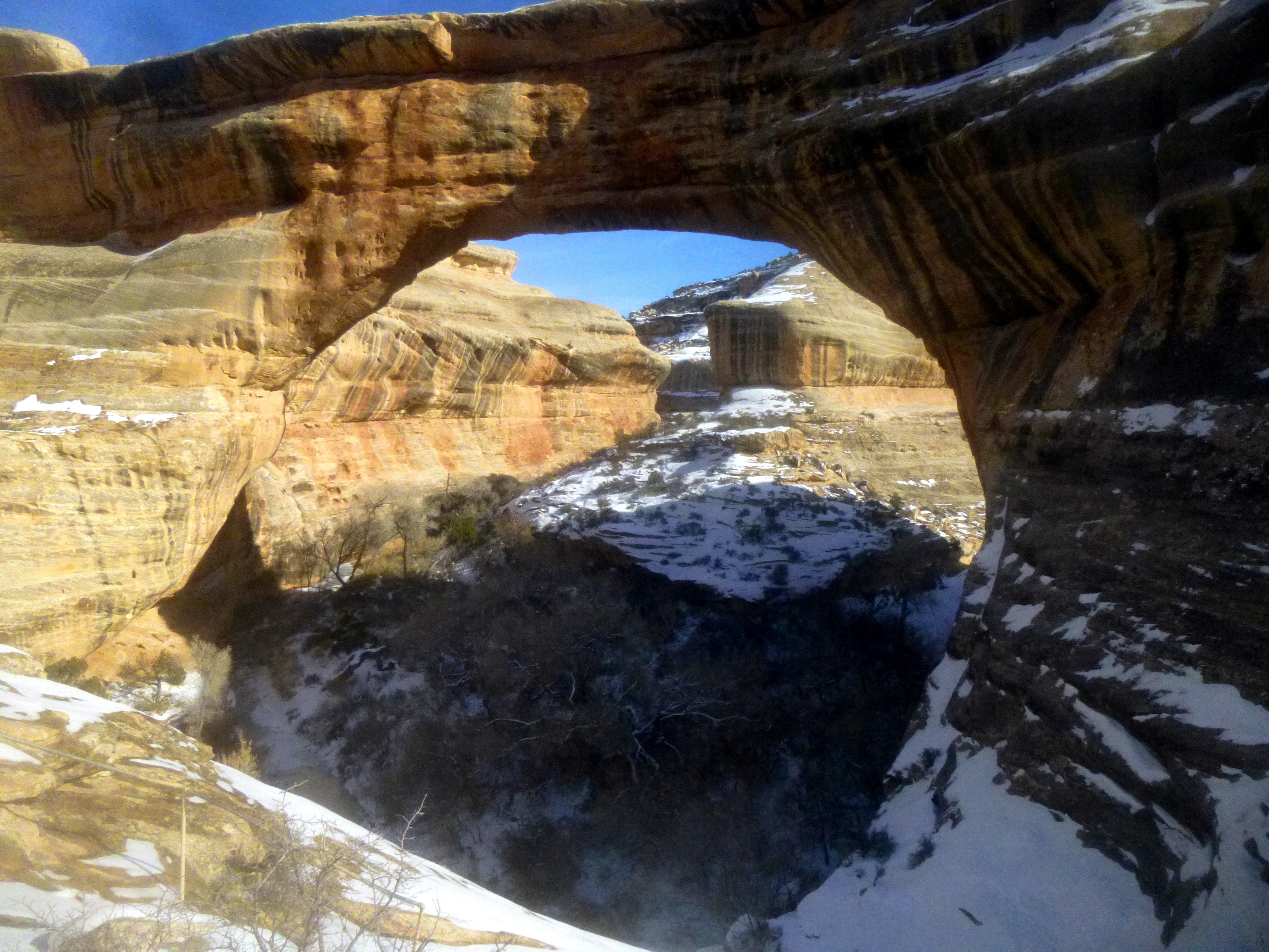
Mighty Sipapu Bridge takes its name from Hopi mythology: “sipapu” is the passage through which human souls pass to reach the spirit world. The impressive height and span—forming North America’s second largest opening by a natural bridge—can be glimpsed from the parking lot some 500 feet above, but the most awe-inspiring views require descending below the rim.
The 1,000 yards (0.6 mile) from the road to the canyon bottom constitute the steepest portion of the Loop Trail; they are also perhaps the most scenic. Immediately, as the path leaves the parking lot, it drops into White Canyon, affording excellent views to both the west and east. Steep switchbacks eventually give way to a short flat stretch following the length of a shelf, about 100 feet below the rim. This quickly gives way to a not-so-natural metal staircase that aids the descent to the bottom of a 20-foot cliff. Within seconds of the end of the stairs, the trail drops off a ledge again, this time assisted by a short wooden ladder.

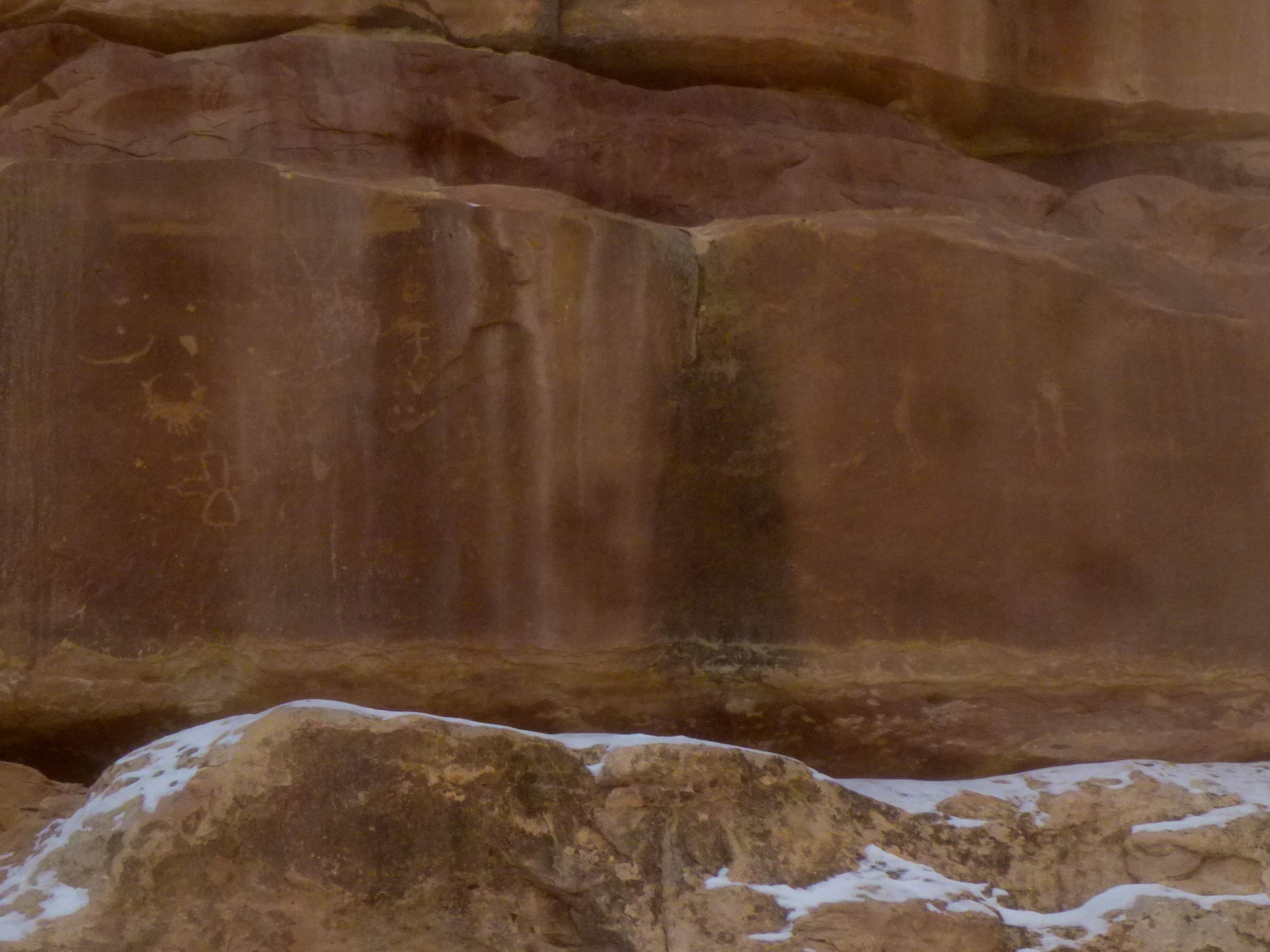
After descending a number of manmade steps, the incline briefly eases as the trail edges the top of a shelf, shaded by a beautiful overhang streaked with black, manganese-rich desert varnish. You will find in this alcove a small Anasazi ruin, a semicircle of stone hemmed in by the canyon walls.

Here the trail splits: a short, level walk leads out to the Sipapu Bridge Overlook, offering an impressive view of the oval-shaped opening below. The awesome alcove facilitates booming echoes; the sounds of hikers are magnified many times over.


Returning to the main trail, you are greeted with another steep slope abutted by oaks, pinyons, junipers, and sagebrush. After 150 yards or so, the slickrock takes over and the incline transforms into such a steep declivity that handrails and additional ladders become necessary to complete the descent. All the while, however, you are rewarded with fantastic views of Sipapu and the feeling that you are descending into the heart of the archway.

At the end of the descent, the slickrock ends abruptly and is replaced by fertile soil below your feet. A seasonal stream cuts through Sipapu, gradually expanding the size of the bridge’s mighty cavity. Spanning both sides of the wash, you will find a collection of Gambel oaks, cottonwoods, and the occasional Douglas fir. As you begin to head down White Canyon, you will encounter seas of rabbitbrush and groves of hydrophilic willows.

White Canyon – Sipapu Bridge to Kachina Bridge
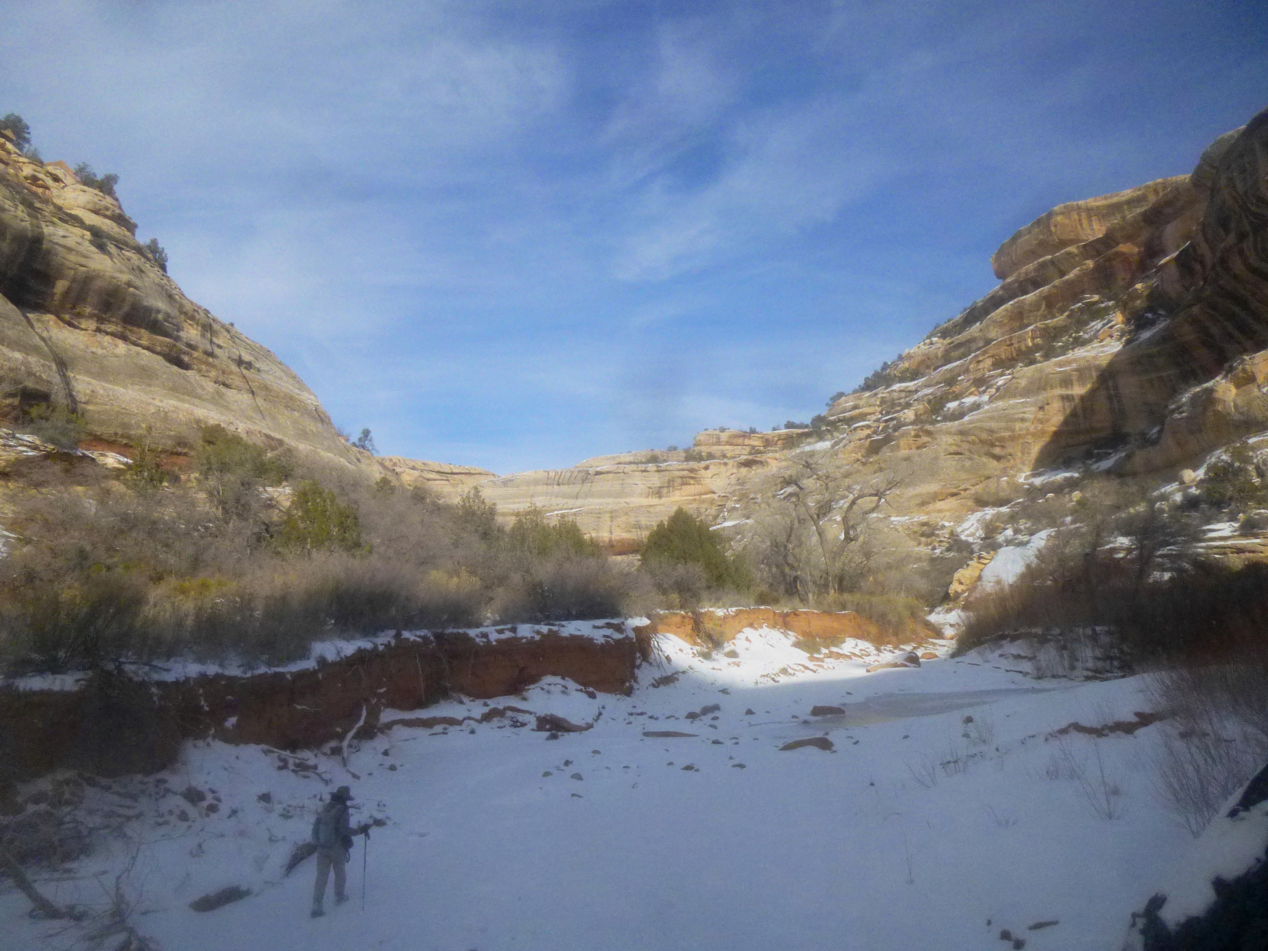
Beyond Sipapu, an unmaintained trail follows winding White Canyon for 2.3 miles to Kachina Bridge. There is indeed a path to follow, but it is faint at times and often crisscrosses the wash (which had a flowing stream, covered in a walkable layer of ice, when I hiked in January). The sandstone walls of White Canyon frequently protrude into the wash, forming beautiful, sweeping alcoves. Desert varnish is ubiquitous, as are traces of the ancestral Puebloans, who built homes, kivas, and granaries amid the canyon’s intricate structure of cliffs and ledges. Roughly 0.8 miles from Sipapu Bridge—250 yards beyond the mouth of Deer Canyon, which runs north out of the park—a short spur trail leads to Horsecollar Ruin, the remains of an old ancestral Puebloan community. (Alas, I missed the turnoff amid the snow.) There is also reportedly a small natural arch visible around here along the opposite wall.

With about 1/3 mile to go to Kachina, another arch—dubbed Rock Ruin Arch—appears ahead on the skyline (many are likely to prematurely confuse this for Kachina Bridge, which is actually at a far lower elevation). Before you know it, the gently sloping trail rounds a bend that reveals a beautiful natural bridge ahead.
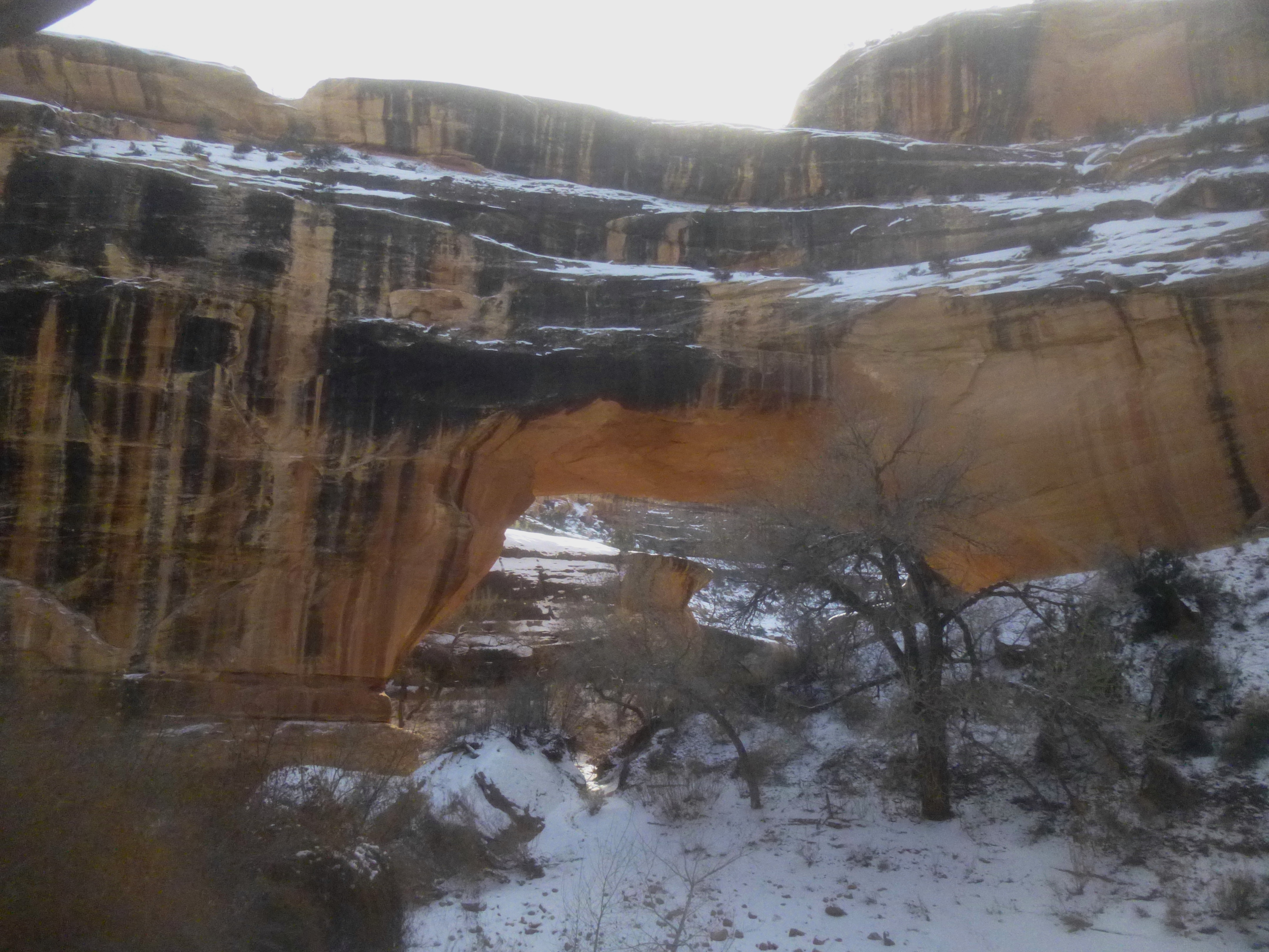
Kachina may be not be the most awe-inspiring of the three bridges, but the atmosphere under and around the bridge resembles that of a hidden grotto—a lush den of oaks and junipers at the confluence of two serpentine canyons. White Canyon continues off to the west; Armstrong Canyon begins to the south.

Approaching Kachina’s thick span from the north, look for a collection of Puebloan petroglyphs etched into the wall on the left. Passing under the bridge, scramble up the slope on the right to explore a string of ancient dwellings constructed from mud and stone. Behind them on the southwest wall of Kachina are another collection of petroglyphs and pictographs. Finally, as you enter Armstrong Canyon, you can spot an impressive etching of a bighorn sheep, with a flurry of faded figures just below it. Of course, admire, but don’t touch!


Armstrong Canyon – Kachina Bridge to Owachomo Bridge
Leaving Kachina Bridge behind (reluctantly), it is a little over ¼ mile—and an elevation gain of 100 feet—to the junction with a trail leading up to the Kachina Bridge parking area. The viewpoint atop the rim is visible high above. From the junction—continue right toward Owachomo Bridge—the unmaintained trail veers off to the right, flanking the left side of Armstrong Canyon to bypass the “knickpoint” pour-off, a 15-foot dry fall that interrupts the otherwise level wash bottom.

Though not as deep as White Canyon, Armstrong Canyon is just as colorful, and desert varnish leaves its mark on nearly every wall. Rounding a lengthy bend, the footpath stays mostly to the right side of the wash. Cottonwoods, willows, and Douglas firs abound. Around the corner at the end of a 1/3-mile flat stretch, the trail crosses a prominent but brush-clogged tributary wash coming in from the left. Do not confuse this ravine for the less congested continuation of Armstrong Canyon, which too bends off to the left just beyond the wash bed diversion. (Finding the trail here was particularly perplexing in the snow.)
The next two miles weave in and out of the wash bottom, passing through riparian scrub. About 1 ½ miles from Kachina, a tributary wash appears across the canyon on the right. A little over two miles up Armstrong Canyon, a massive hunk of Cedar Mesa sandstone, stripped away from the surface, sits idly atop a bend in the canyon. This peculiar feature is called “the Shoe” (though I think it looks more like a bathtub, or a slug). Shortly after rounding the curve—offering a view of the Shoe from a different angle—the trail abruptly cuts steeply up the canyon’s southern flank to bypass a collection of boulders down in the wash. The path descends as quickly as it rose, landing you back down at wash level for the next ½ mile.

With about ½ mile left to Owachomo Bridge, the loop hike crosses the streambed a final time before ascending the left side of the canyon to a relatively flat bench, about 40-50 feet above the wash bottom.
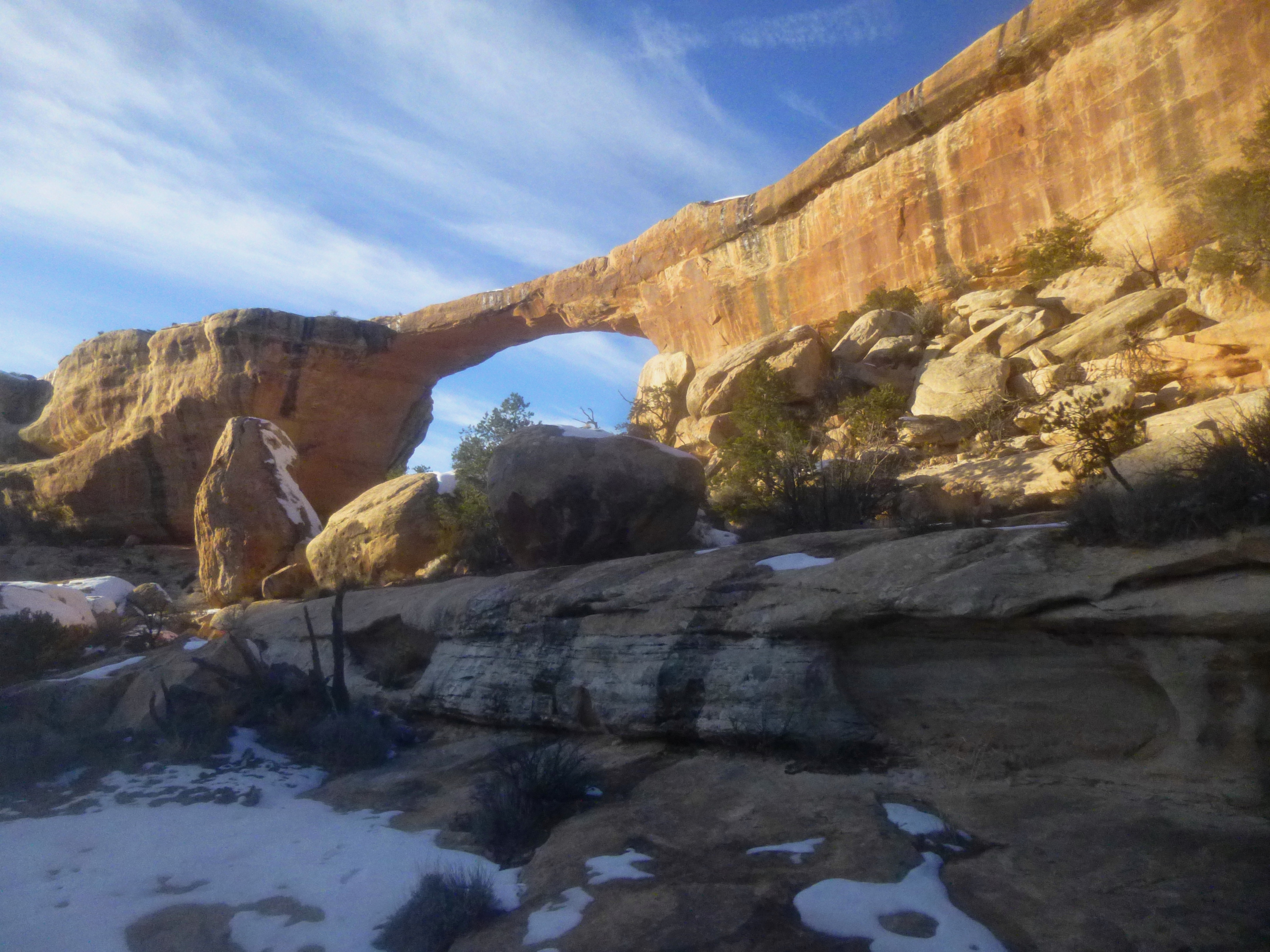
A sharp left turn brings you within striking distance of the third bridge, now visible up ahead and shining in the late afternoon sun (at least in winter). From here it is a short walk to the base of the bridge.

Owachomo Bridge is thought to be the youngest bridge of the bunch, with a fragile span measuring just nine feet thick. It also has what feels like the longest opening, resembling the lengthy reach of Landscape Arch in nearby Arches National Park. Owachomo Bridge was formed by the down-cutting of Tuwa Creek, which has now abandoned its original route in favor of the newer canyon that now bears its name. Viewed from Owachomo, present-day Tuwa Canyon winds off to the east, while Armstrong Canyon heads south.

From Owachomo Bridge, there is only 2/10 mile of hiking remaining, a dogged climb up nearly 200 feet to the parking area along Bridge View Drive. The route passes under the bridge itself, crosses the dry, chiseled wash and immediately begins climbing a series of manmade steps. After more than eight miles of walking, the final stretch can feel rather arduous, but the sight of the Owachomo Bridge overlook ahead wills hikers up the final steps to the parking area.
Some 4-6 hours prior, the loop began across the street at the Mesa Trail; after a long and scenic hike (in snow!), it seems like days ago.

Pingback: Hickman Bridge Trail (Capitol Reef National Park, UT) | Live and Let Hike
Pingback: Easy Weekend Trip Part 3: Natural Bridges • Hand-Me-Down Experience