

The 0.9-mile trail to Hickman Bridge is Capitol Reef National Park’s most popular hike, and it is easy to understand why. The trail is well-marked, well-maintained, and conveniently located (less than two miles from the Visitor Center) and features fantastic views of the Waterpocket Fold, as well as, of course, the majestic natural bridge itself. Visitors coming from nearby Arches National Park might choose to pass on this hike, but for others looking for a casual, 1-2 hour hike, it’s likely to be the Visitor Center’s top recommendation.

The hike
Access to the Hickman Bridge Trailhead is straightforward. From the Visitor Center, turn right onto east-bound Highway 24, drive 1.9 miles, then exit left at a good-sized parking lot (with a pit toilet) marked “Hickman Natural Bridge.” On busy days in peak season (generally spring and fall), arrive early in the morning to secure a parking space (and to avoid crowds). (Note: For photographers, lighting on east-facing Hickman Bridge is also slightly better in the morning.)
Capitol Reef has recently installed new wayside exhibits at each of its most popular trailheads, and the signage at Hickman Bridge features a short description of the hike, as well as a colorful map and graph of the elevation gain (400’). Trail guides are available for 50 cents. The wide and well-worn trail begins just beyond.
For the first 2/10 mile, the Hickman Bridge Trail parallels the rushing Fremont River, one of only a handful of perennial streams cutting through the 100-mile long Waterpocket Fold. On the opposite side, the trail passes under a blocky wall of red-tinged rock. While stable, this wall is far from impervious to nature’s elements: as recently as March 2013, a significant rockfall in this section closed the trail for more than eight months (it reopened in November 2013). Newly-installed signage (warning visitors of the “rockfall hazard area”) encourages hikers to hold their breath as they scurry past the exposed cliff face.

After a couple hundred yards of relatively easy walking, the trail begins to switchback, climbing 100 feet to the top of a grassy bench. Upon cresting the shelf, look for a dusty path veering off to the right: this short spur leads to the boulder remains of a Fremont pit house. In contrast with their cliff-dwelling neighbors, the ancestral Puebloans or “Anasazi,” the natives of this area known to archaeologists as the “Fremont Culture” (roughly 600-1300 AD) lived in standalone homes with thatched roofs.
The same basalt boulders utilized for the foundations of Fremont pit house litter the terrace surrounding the Hickman Bridge Trail. In a park founded on the basis of its stunning sedimentary rock layers, it’s quite obvious that these igneous rocks suggest a secondary, volcanic activity at work. Though the delivery mechanism remains relatively unclear, geologists trace the origins of the rounded basalt to cooled lava atop nearby Boulder Mountain and Thousand Lake Mountain. Through a series of debris flows, floods, and perhaps glacial activity, these igneous deposits were dumped into the Fremont River watershed, likely within the last couple million years. The relatively flat terrace encountered on the Hickman Bridge hike was once the floodplain at the time of boulder deposition—erosion and down-cutting of the Fremont River has since left the shelf 100 feet above the canyon floor.
After less than a minute of level walking, the stepped footpath ascends again to a trail fork—a much longer and strenuous trail to Rim Overlook and Navajo Knobs veers off to the right.

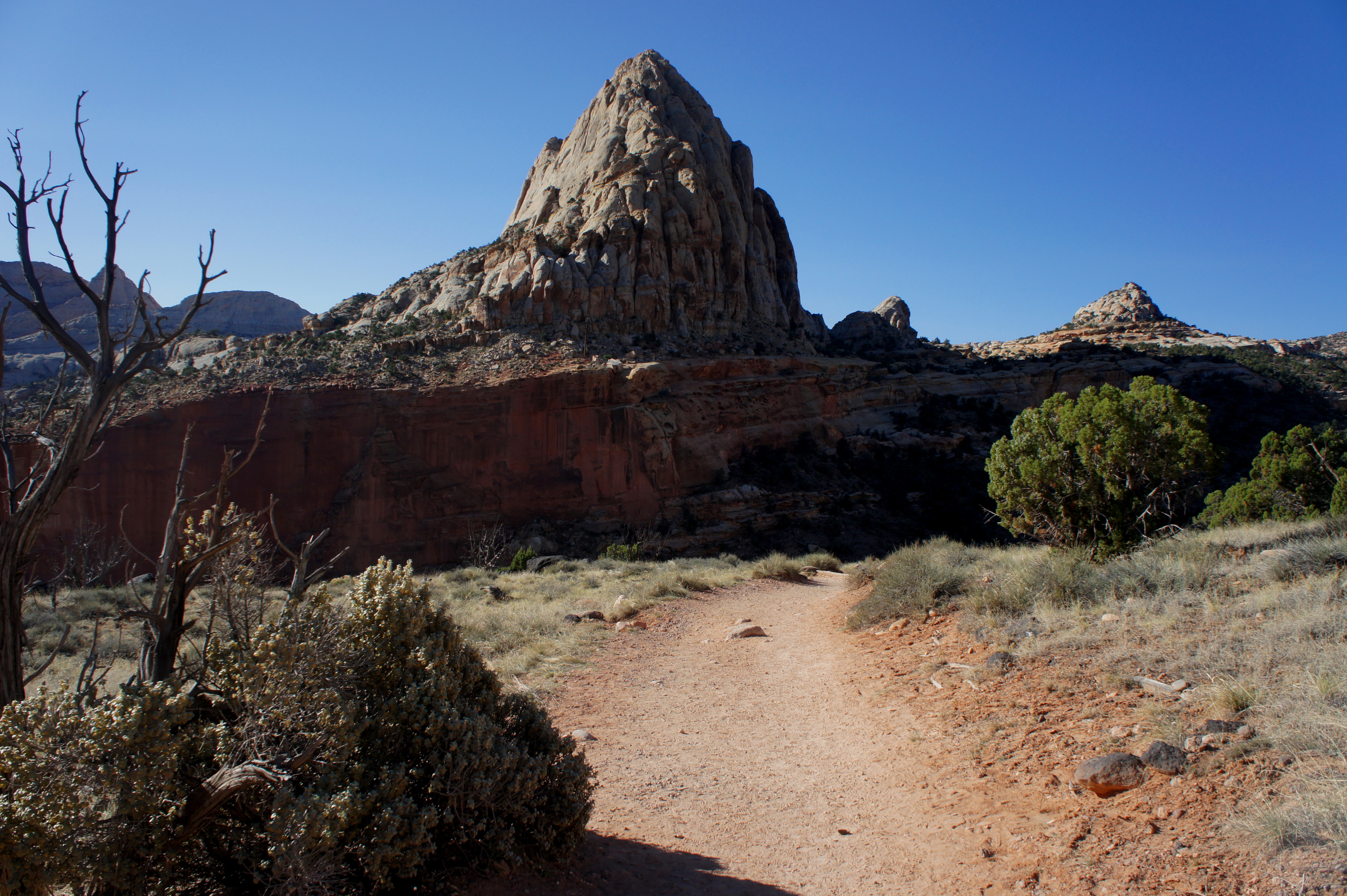
Bearing left at the junction, the trail to Hickman Bridge climbs a third time, cresting a low hill that affords excellent views of several whitish, Navajo sandstone domes. The cone-shaped point to the north is called Navajo Dome; the towering dome behind it, to the west, is dubbed Walker Peak. Across the Fremont River Canyon to the south, Pectol’s Pyramid (6,207’)—named for Ephraim Pectol, one of the original boosters who facilitated Capitol Reef’s national monument status in 1937—dominates the landscape. Off to the east is Capitol Dome (actually a series of fins), to which Capitol Reef owes its name.
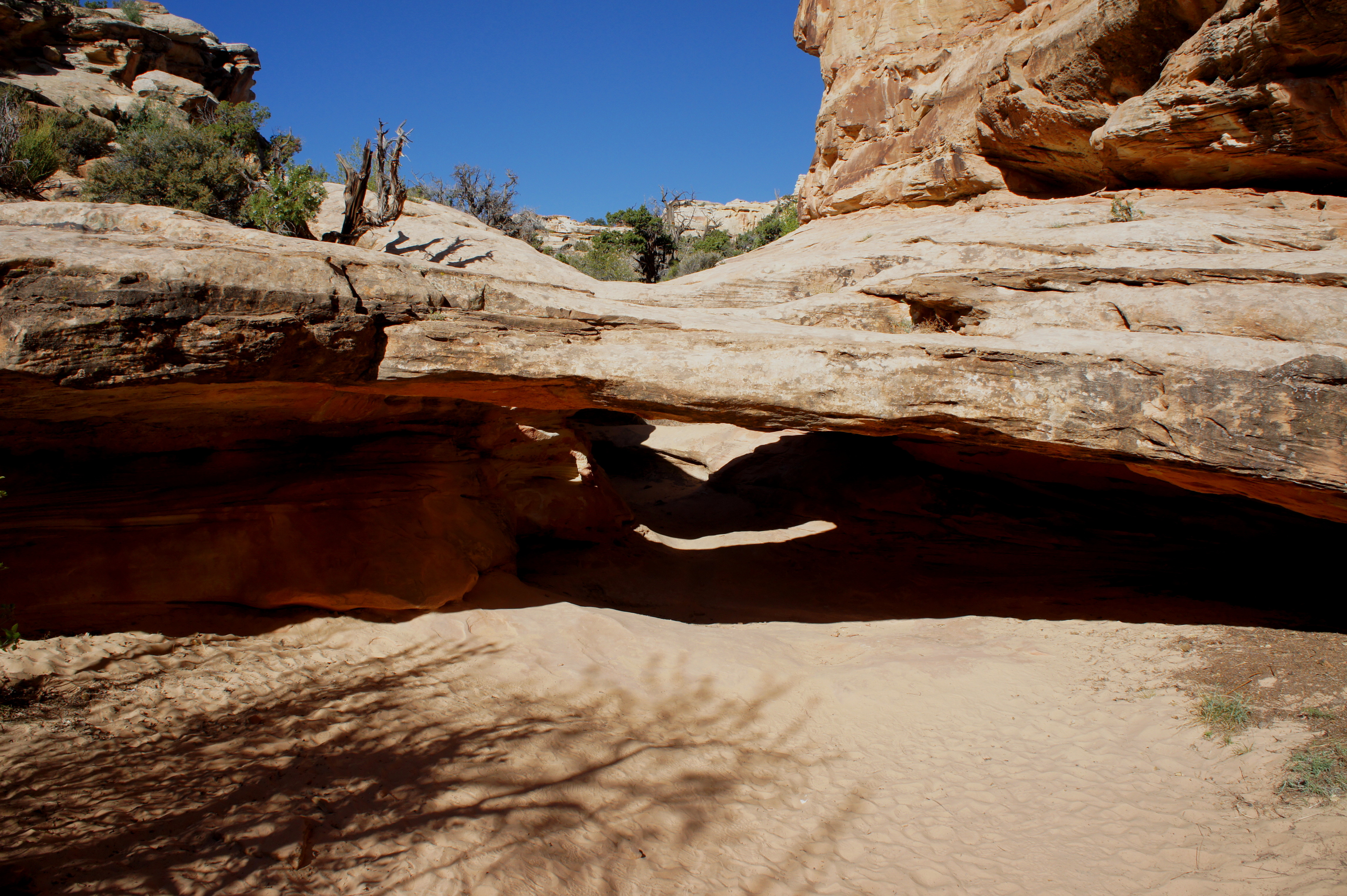
Beyond the boulder-strewn knoll, the trail descends among junipers and pinyon pines to a sandy wash bottom in a minor canyon previously shielded from view. This canyon has been cut into the Kayenta formation, a relatively durable sedimentary rock layer responsible for capping the more fragile, cliff-forming Wingate sandstone below. (Note: Being an amalgam of sandstones, siltstones, and conglomerates, however, the Kayenta has areas of weakness—as evidenced by the gaping hole in a fin that formed Hickman Bridge.)
Upon reaching the dry wash bottom, the trail passes a metal survey marker and begins to flirt off and on with Kayenta slickrock. The path, unmarked but bounded by well-placed stones, generally hugs the left-hand side of the canyon as it works its way upstream. Within five minutes of entering the drainage, look for a small natural bridge off to the right. This minor cavity, once a pothole, is known to arch hunters as Nels Johnson Bridge, named for the first permanent, Euro-American settler in the area in 1880.
The trail beyond climbs slickrock to the beginning of a short loop section—a 1/3 mile circuit that passes under and around Hickman Bridge, which at this point is visible slightly off to the right. Bear right, heading toward the bridge straight on.

Hickman Bridge is notoriously hard to photograph, as its relative proximity to the canyon wall behind it masks blue skies. Boasting a 133-foot span and 125-foot height, however, the natural bridge remains an impressive sight. (In contrast with arches, natural bridges are carved by free-flowing water (see my Natural Bridges Loop Trail post for a longer explanation).)

After passing directly under the span, a relatively faint path cuts left around a bend, leaving Hickman Bridge behind as it crosses a minor drainage and leads to a fine viewpoint of the Fremont River valley, the historic Fruita pioneer community, and Fremont Gorge to the east. Bear left again, descending back to the start of the loop. From here, it is a roughly ¾ mile walk back to the trailhead.


My husband and I are headed out there in May, so we’re soaking up your great info and pics. Do you have a number one/can’t miss? We’re doing Bryce, Escalante, and Capital Reef.
Hi there! Thanks for reaching out – sounds like a great trip. Would highly recommend the 6-mile round trip hike to Lower Calf Creek Falls in Escalante (see here: https://liveandlethike.com/2014/12/28/lower-calf-creek-falls-trail-grand-staircase-escalante-national-monument-ut/). In Capitol Reef, you can’t go wrong with any of the maintained trails, though I’d say Cohab Canyon is my favorite (alas, no post on that one yet). Grand Wash is also a must-see (https://liveandlethike.com/2014/12/15/grand-wash-trail-capitol-reef-national-park-ut/), and for solitude, try the often-overlooked Fremont Gorge Overlook Trail (https://liveandlethike.com/2014/12/21/fremont-gorge-overlook-trail-capitol-reef-national-park-ut/). Let me know if you need additional advice/recommendations!
You are awesome. If we get torn between two choices, I’ll definitely ask for advice!