
Capitol Reef National Park—a long, skinny unit comprising 378 square miles in the heart of Utah’s canyon country—can be divided conceptually into three separate districts, each with a unique flavor. Around 95 percent of visitors flock to the central Fremont River District, which includes the Highway 24 corridor and the Scenic Drive. Ambitious day hikers, canyoneers, and backpackers may opt for the southern Waterpocket District, home to many of Capitol Reef’s best long hikes. Less than 1 percent will visit the third and final area, the wild and beautiful Cathedral Valley District.
The primary deterrent to visiting Cathedral Valley is the difficulty of access. Reaching this district requires miles of rugged, backcountry driving, a river ford, and a good deal of patience. Even in the best of conditions, an average passenger sedan will not do the trick; high-clearance is required, with four wheel-drive (4WD) recommended. After snowfall or recent floods, Cathedral Valley may become impassable to even the toughest of jeeps—check with the Visitor Center for latest conditions. (Note: I assure you, you do NOT want to try the Cathedral Valley loop when it is muddy—towing expenses soar to as much as $1,000 in this remote area.)
With good weather and a proper vehicle (think Ford Escape or the like), the wonders of Cathedral Valley await. Most visitors trace a 59-mile circuit to and from Utah Highway 24, a drive that demands a half to full day to complete. Six short hiking trails—mostly quick jaunts out to scenic overlooks—offer opportunities to get out of the car to stretch your legs:
- Lower South Desert Overlook Trail (0.5 mi. round-trip)
- Lower Cathedral Valley Overlooks Route (1.7-2.4 mi. round-trip)
- Upper South Desert Overlook Trail (0.4 mi. round-trip)
- Cathedral Valley Overlook Trail (0.2 mi. round-trip)
- Morrell Cabin Trail (0.4 mi. round-trip)
- Cathedrals Trail (2.2 mi. round-trip)
From Highway 24, visitors are advised to complete the loop in a clockwise direction, beginning on the Hartnet Road and returning via the Cathedral Road. The primary reason is the presence of the River Ford, where the Fremont River normally runs around a foot deep—but, with higher water levels, can be enough to turn people around in the event of higher water levels. As the crossing is situated near the start of the Hartnet Road, one could imagine the frustration in driving the lengthy loop in a counterclockwise direction only to find the ford at the end impassable.
From the Capitol Reef Visitor Center just off Highway 24, drive east for approximately 12 miles, leaving the park after nine. At mile marker 91, look for a sign indicating “River Ford” – take a left onto the graded dirt track. Follow this road for 6/10 mile to the crossing. One must drive downriver for a couple dozen yards before the road reemerges on the opposite bank. (Note: It is usually advised that drivers hug the right bank until pulling even with the exit; the left side is generally deeper.) Do not be afraid to step on the gas, as the incline of the sandy slope on the north bank can be quite slanted.
Still well outside the park, the road beyond the River Ford winds bends and twists amid minor hills in the Morrison formation, a fossil-rich rock layer dating to the Jurassic Period. Nine miles from Highway 24, the Hartnet Road climbs into the Bentonite Hills, named for the soft bentonite clay that typifies the Morrison’s Brushy Basin Member. (Note: Bentonite clay becomes notoriously muddy after rains—all the more reason to check with the Visitor Center for latest road conditions before departing.)

The tan-colored (and rather unattractive) Salt Wash Member of the Morrison predominates along the Hartnet Road as it approaches the park boundary. Fourteen miles from Highway 24, a spur road on the left leads to the Lower South Desert Overlook, where the bottom suddenly drops out, revealing a kaleidoscope of colors surrounding the valley below.
Back on the Hartnet Road, drive 2.3 miles through Hartnet Draw to the park boundary. The Lower Cathedral Valley Overlooks Route begins a short distance up the road on the right. The next destination of note is 10 miles farther—a short spur road leads to the Upper South Desert Overlook. A more spectacular view can be found at the Cathedral Valley Overlook, less than a mile beyond.
Out of the open desert and into a dense pinyon-juniper forest, the Hartnet Road is at its rockiest just before the Hartnet Junction. At this fork, continue right onto the Cathedral Road, which—just after the 6-site Cathedral Valley Campground—drops around 400 feet in a series of sweeping switchbacks. (Note: While not particularly rugged, these north-facing switchbacks are often the last section of the loop to dry out after winter snows.)
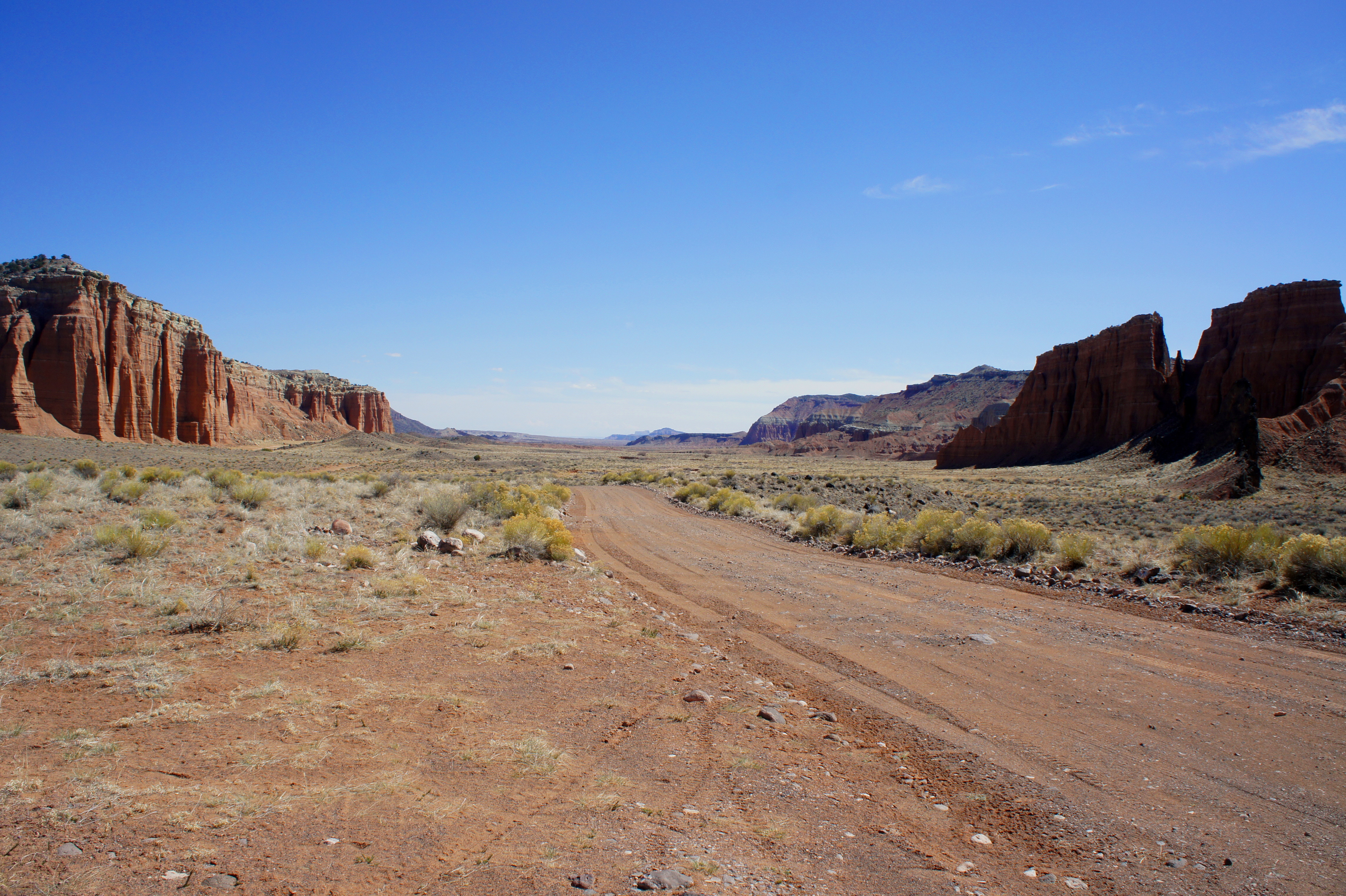
The subsequent portion of the driving circuit is a show-stopper. Here Upper Cathedral Valley is surrounded on all sides by ornate, colorful walls of Entrada sandstone. Situated in the center of this broad basin, a line of towering monoliths known as the Cathedrals glistens in the beaming sun. Those with an affinity for history may enjoy the short hike to Morrell Cabin, an old cowboy outpost dating to the 1930s. There is also a 2.2-mile out-and-back trail that follows the Cathedrals from east to west.
Rounding a corner to the northeast, the Cathedral Road traverses the barren Middle Desert, bounded on both sides by flamboyant cliffs. The Cathedral Valley Junction—where the Baker Ranch Road takes off to the north—sits at the doorstep of a coal-colored volcanic dike. More of these basalt plugs will be visible as visitors venture farther east.

Another unusual geological feature of note is the Gypsum Sinkhole, a deep chasm formed when the bottom gave out on a mass of selenite, a variety of the mineral gypsum. A short spur road leads south—amid the Walls of Jericho—to the sinkhole.

Several wash crossings—some of which may have flowing water—are necessary to reach the final destination on the drive, Lower Cathedral Valley. Along the way, enjoy splendid views of the open expanse, including the Little Black Mountains and Factory Butte to the north.
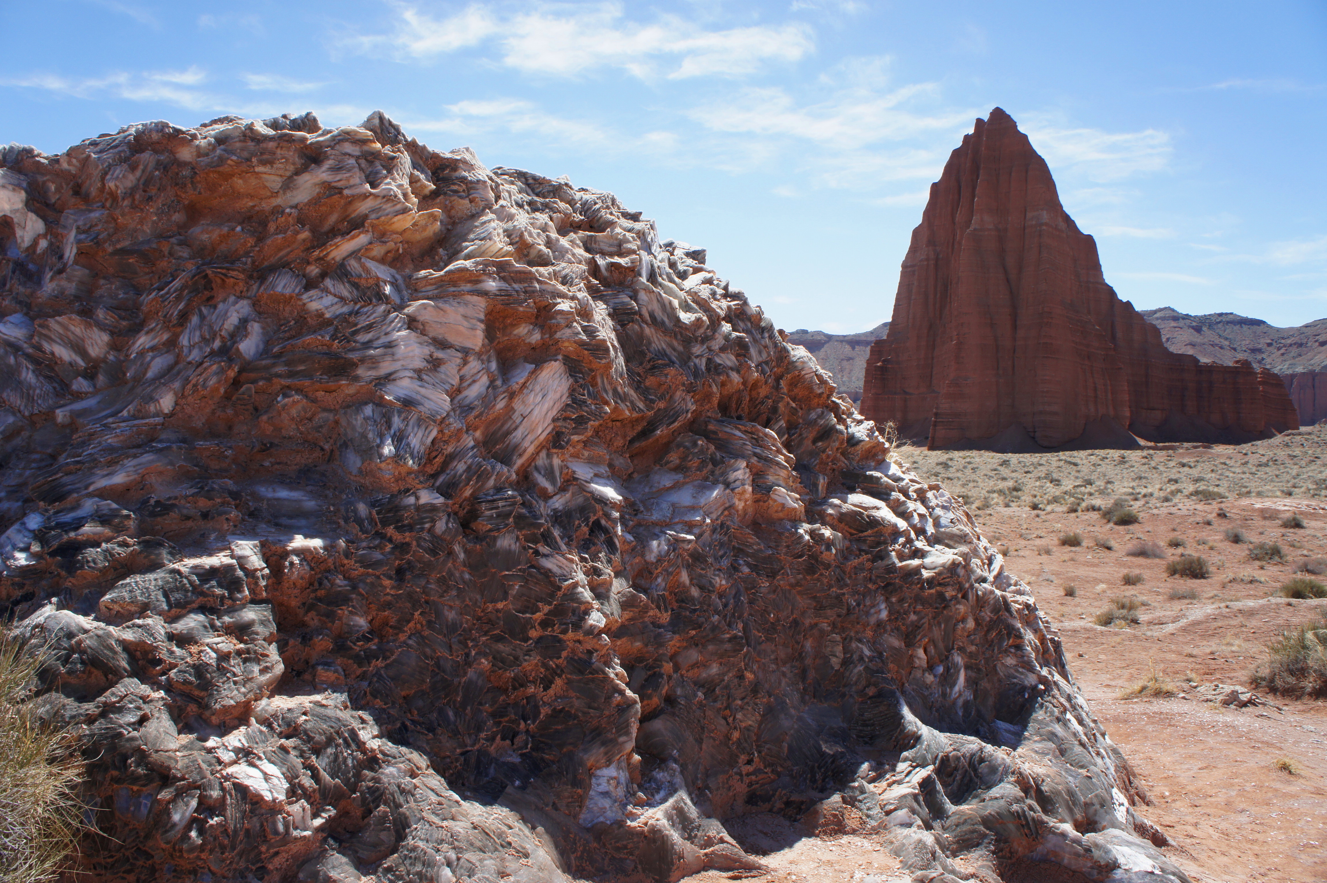
After leaving the park, turn right at the sign for Glass Mountain and the Temples of the Sun and Moon in Lower Cathedral Valley. The Temples are picturesque Entrada monoliths, a must-see for photographers, especially at sunrise. Glass Mountain, situated just outside the park boundary, is not a mountain at all—rather, it is a hefty hunk of shiny selenite protruding out of the sedimentary rock below.

The final stretch comprises a straightforward drive back through mounds of colorful bentonite clay, as well as an interesting maze of white-to-tan canyons in the Salt Wash Member of the Morrison formation. Fifteen miles from the Temples, the dusty Cathedral Road finally meets Highway 24, at a point roughly seven miles east of the start of the Hartnet Road. Head back west to complete the 59-mile circuit. Allow 6-8 hours for the drive, including a few short hikes. Visitors with additional time may spend the night at the Cathedral Valley Campground, which is first-come, first-serve but generally lightly traveled.

Pingback: Хороший отдых | Солнце, месяц и луна
Pingback: The Complete Guide to Visiting Capitol Reef National Park | Utah 2020 | The Partying Traveler