
Throughout much of San Francisco’s history, ships seeking to enter the Bay Area flirted with disaster: jagged rocks, shallow beds, dense fog, and nasty waves left hundreds of vessels in the 19th and 20th centuries capsized, torn apart, and buried at the ocean floor. As thousands of gold prospectors—from all over the world—flocked to San Francisco after 1848, the tumultuous sea passage was unsustainable: something had to be done. As a partial fix, the city built a series of lighthouses, including a prominent guiding light at Point Bonita, situated at the entryway to the Golden Gate from the vast Pacific Ocean. The lighthouse was rebuilt and improved several times in the decades that followed—and yet still failed to prevent many fatal maritime disasters. Only with the invention of modern technology and an advanced traffic monitoring system has the risk to ships significantly declined, yet reminders of yesteryear remain at places like Point Bonita Lighthouse, which remains standing today.
The lighthouse is now administered as part of the Marin Headlands unit in Golden Gate National Recreation Area, the most visited National Park Service site in the country in 2018. A mostly paved/well-graveled trail offers access to the lighthouse, which is open three days a week (Saturday, Sunday, and Monday) from 12:30-3:30pm.
The hike
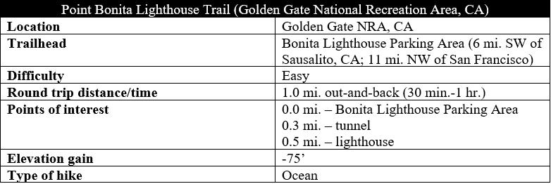
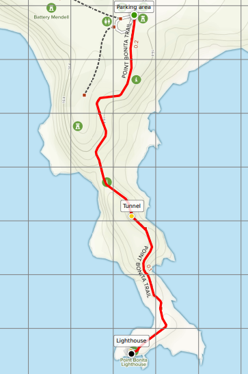
The Point Bonita Trail begins at the Bonita Lighthouse Parking Area, situated roughly four miles west of the Golden Gate Bridge in Golden Gate National Recreation Area. (Note: Along the way, stop by the Marin Headlands Visitor Center for information.) There is, however, very limited parking at Bonita Lighthouse. Expect to have to find a spot instead, back up Field Road about 3/10 mile, at Battery Alexander Parking Area, which is considerably more spacious. (Note: From here there is a 3/10-mile connector trail that follows the road down to the Bonita parking area.) This area was previously part of Fort Barry, a former Army base active during the first half of the 20th century. The army’s primary purpose here was coastal defense, lining the cliffs of the Marin Headlands with artillery batteries that, fortunately, never saw action during World War I or II.
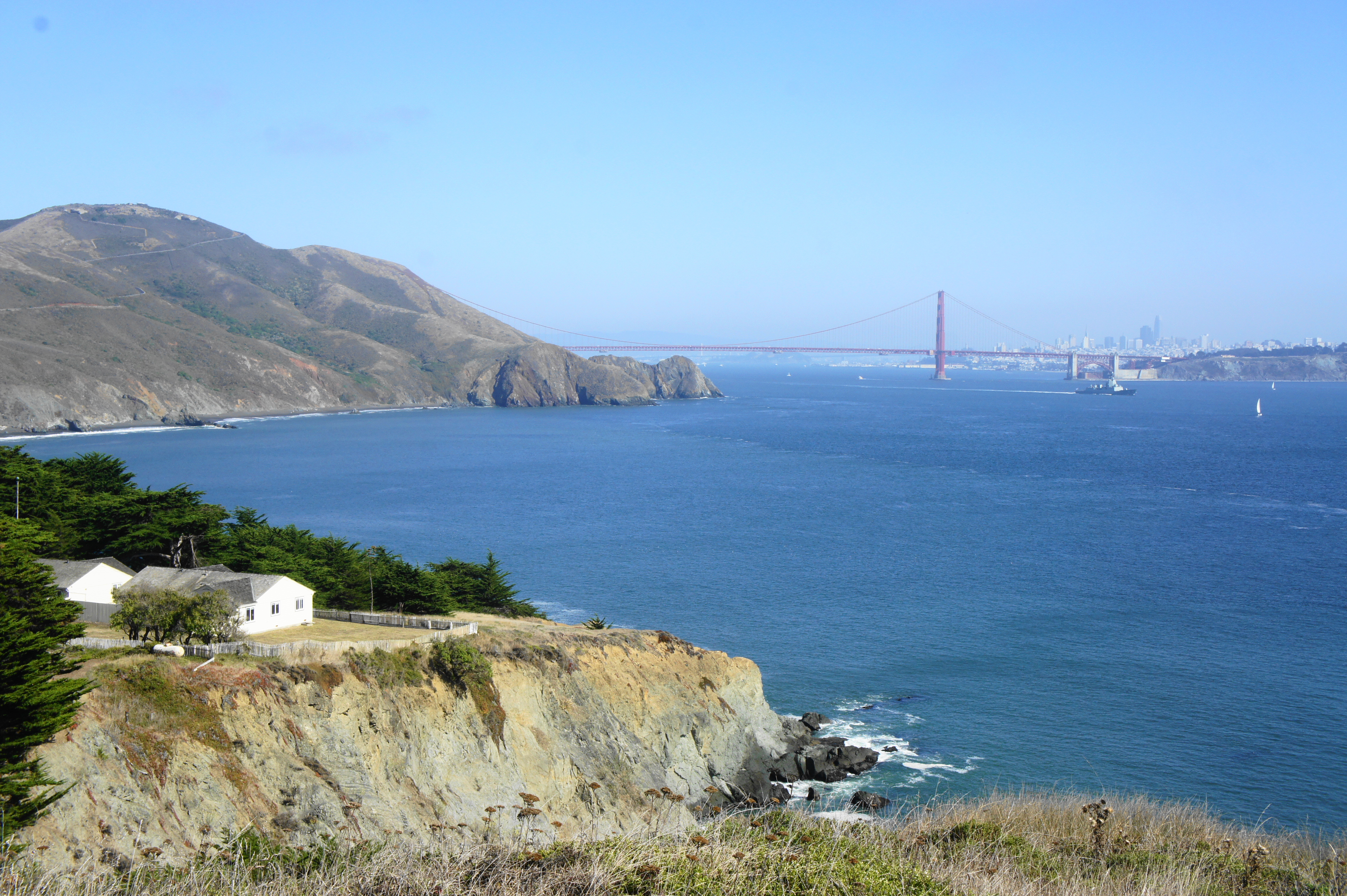
Starting at the information sign for the Point Bonita Trail, hikers are immediately greeted with stunning views (on a clear day, of course) of San Francisco, Hawk Hill (905’), and the Golden Gate Bridge, the iconic structure connecting the city to the Marin Peninsula. The path begins as a wide, fully-paved path that is wheelchair-accessible. Sporadic benches provide a chance to sit down to take in the eastward vistas.
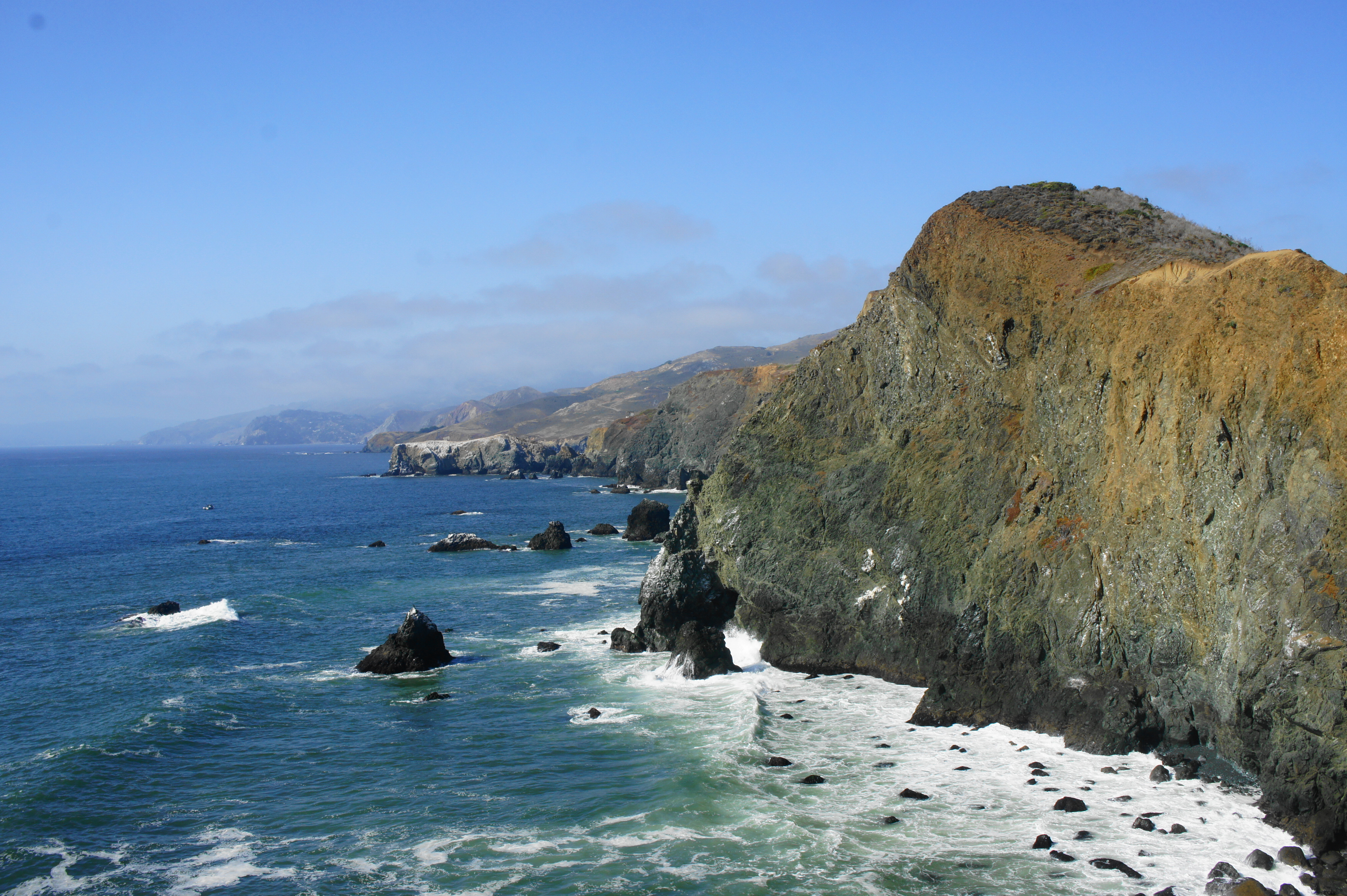
As the route bends westward at 1/10 mile, the rest of the Point Bonita Peninsula comes into view: a series of jagged rocks with near-vertical cliff faces. The continuing path is visible down below as it enters a man-made tunnel in the rock: this is your route to the lighthouse. As the trail descends, it curves around Point Bonita Cove, an excellent place to spot the Bay Area’s famed harbor seals and California sea lions, who gather here in bunches at certain times of year. To the west (the opposite direction), the vast Pacific Ocean is visible in all its splendor.
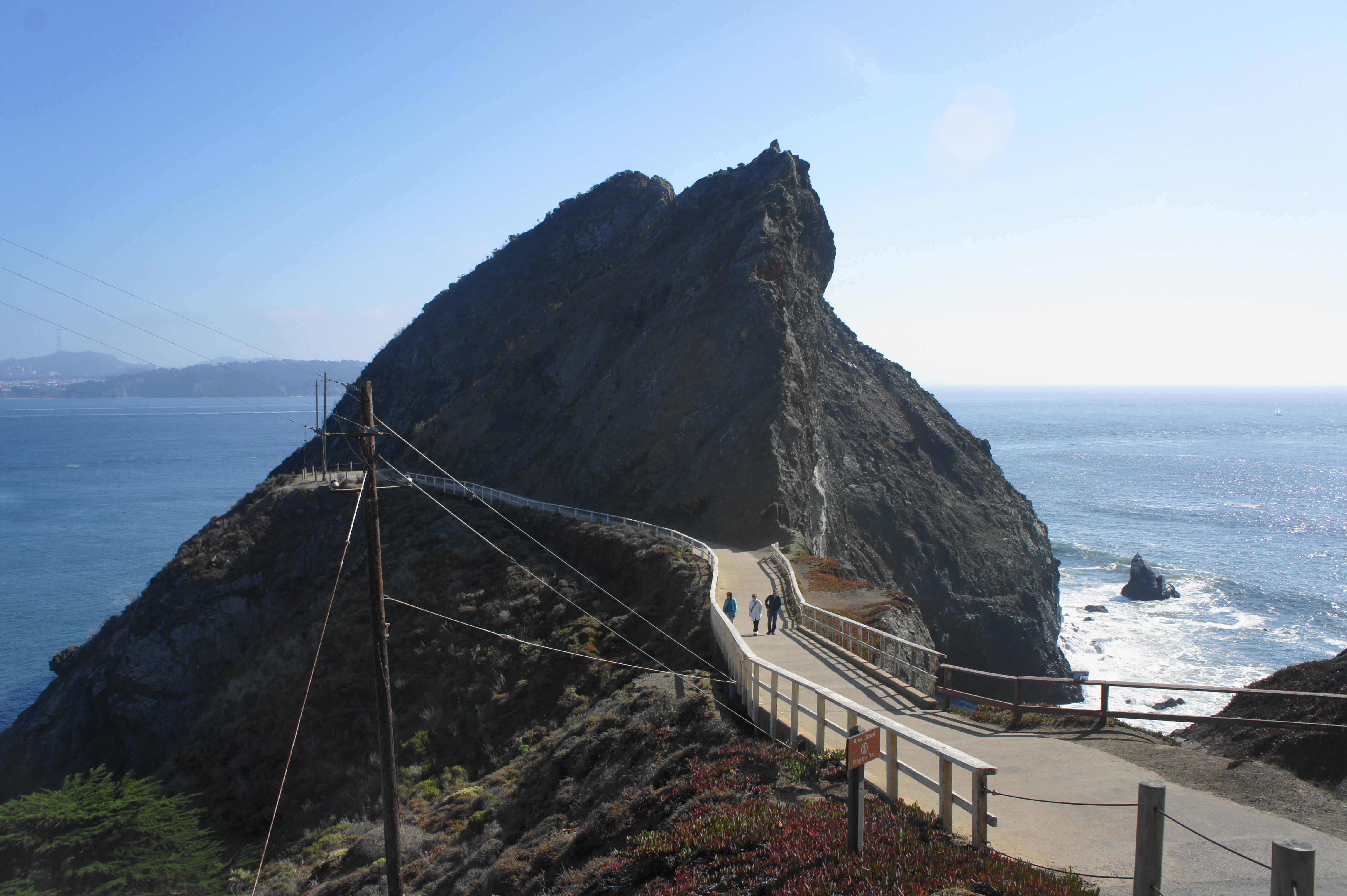
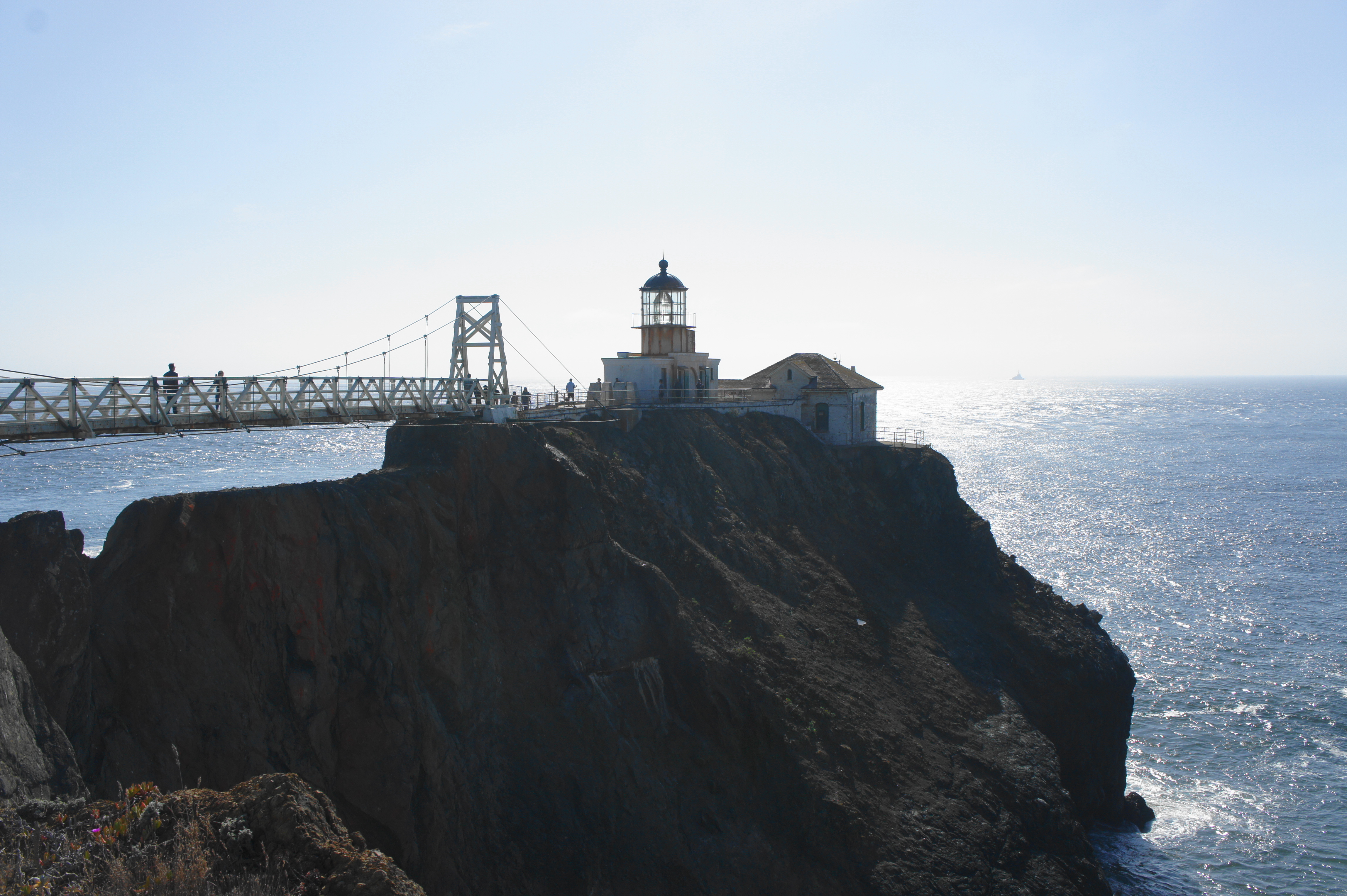
After the relatively steep descent, the trail crosses a bridge and enters a short but dark tunnel, after which the pavement ends, replaced by crushed gravel. Upon passing under a set of power lines, hikers will get their first views of the Point Bonita Lighthouse on the right. First constructed in 1855, the lighthouse was moved to its current location in 1877.


It’s a short walk from here to the suspension bridge that provides passage over choppy waters to the lighthouse. (Note: This area is only open Saturday-Monday from 12:30-3:30pm.) At this beacon on the sea, the end of the half-mile trail, visitors can peer into the Fresnel lens and read about the history of the lighthouse and sea navigation in the Bay Area. And vistas, of course, are sublime, especially as the sun begins to set over the Pacific Ocean and waves crash against the towering cliffs, which stretch off to the horizon to the north. Although it can be crowded, detracting slightly from the scenery, Point Bonita offers one of the best panoramas in the area.


Once you’re ready, head back the way you came, this time climbing uphill to regain the 75 feet in elevation shed on the route to the lighthouse. Expect to spend at least 30 minutes to an hour at this spectacular sight, a terrific blend of natural ruggedness and Bay Area human history.

Pingback: Coastal Trail to Tennessee Point (Golden Gate National Recreation Area, CA) | Live and Let Hike