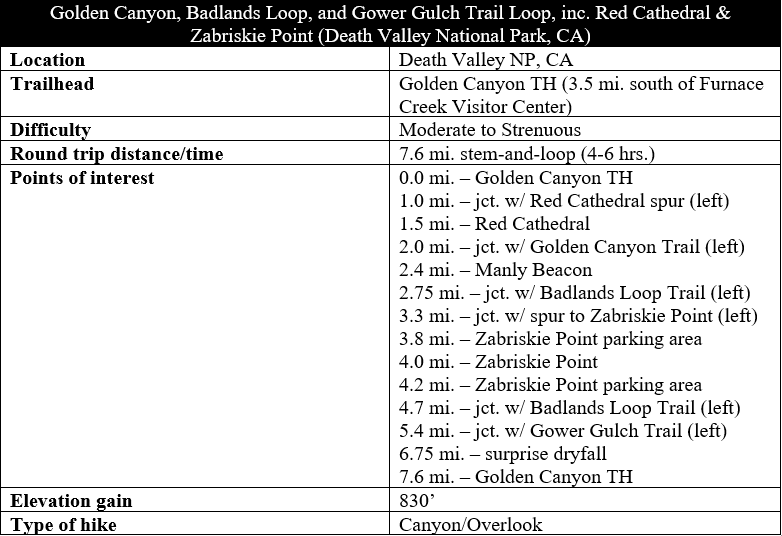
The Golden Canyon Trail is one of the most popular hikes in California’s Death Valley National Park—and with good reason: its dazzling colors, sun-soaked badlands, and valley views entice hikers of all stripes to the park’s Furnace Creek area. Yet far fewer visitors combine Golden Canyon with the adjacent Badlands Loop and Gower Gulch Trails, stringing together an excellent, moderately-difficult circuit. Adding in side trips to the fluted cliffs of Red Cathedral and the popular viewpoint at Zabriskie Point, the 7.6-mile stem-and-loop trek described below is one of Death Valley’s showstoppers, a must-see for any hiker’s first-time visit to the park. (Note: There are several shorter variants of this hike, such as the Golden Canyon-Gower Gulch Trail Loop, described here.)
The hike
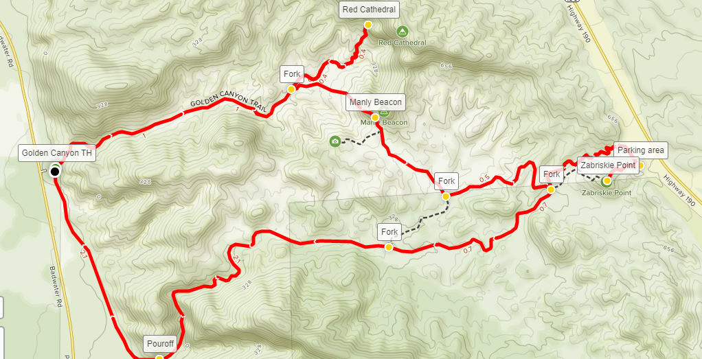
For purposes of this description, the Golden Canyon, Badlands, and Gower Gulch Trail Loop begins and ends at the Golden Canyon Trailhead, situated at the base of the Black Mountains 3.5 miles south of the Furnace Creek Visitor Center in the heart of Death Valley National Park. (Note: However, it is also possible to complete the same loop starting at Zabriskie Point, situated just off California 190, five miles southeast of Furnace Creek.) From Golden Canyon Trailhead, the route follows the Golden Canyon Trail east, briefly detours to Red Cathedral, then climbs steadily to meet the Badlands Loop and Zabriskie Point before descending the Badlands Loop again and tracing the Gower Gulch Trail back to the trailhead.
Golden Canyon Trail to Red Cathedral (1.5 miles)
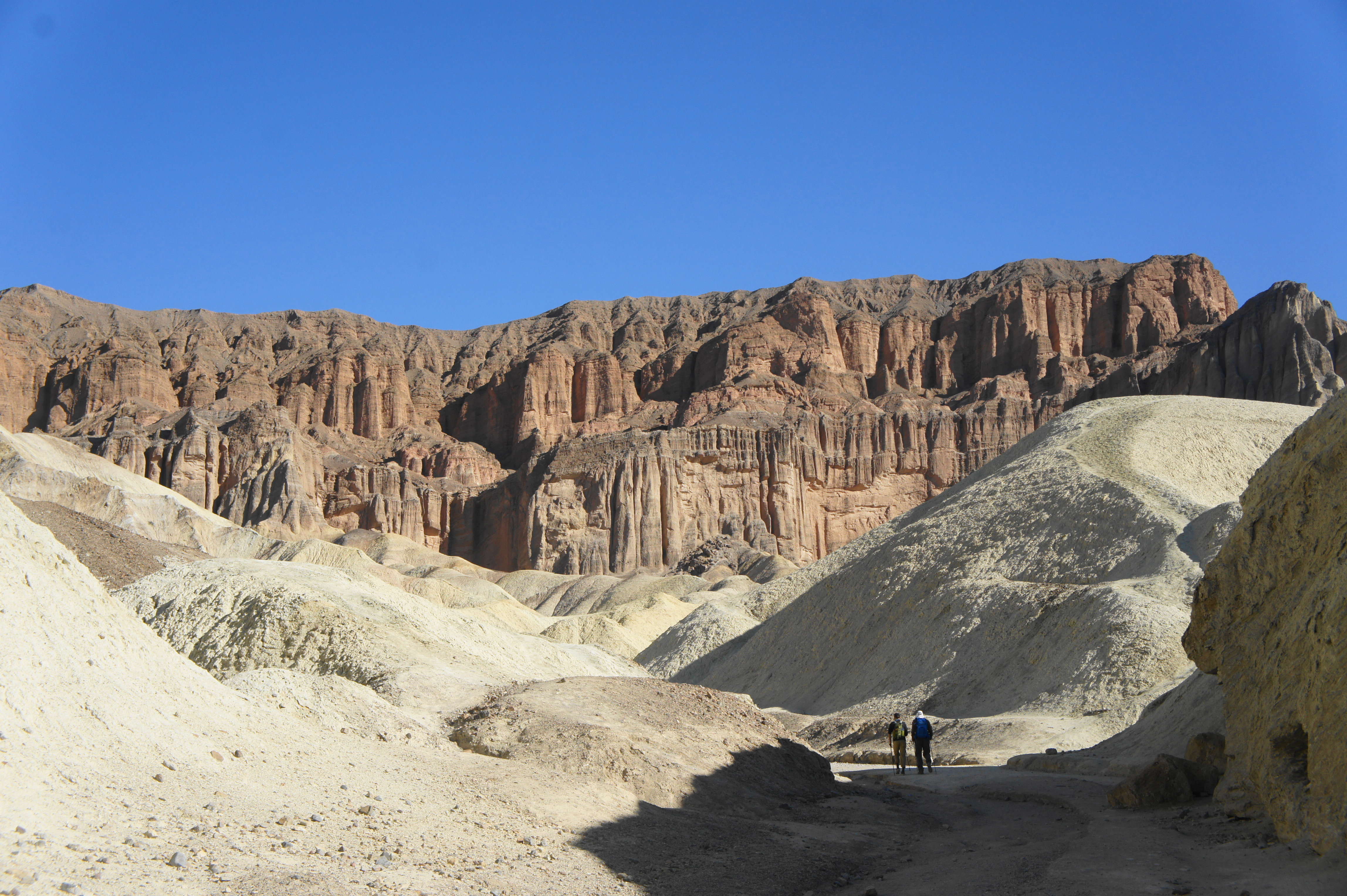
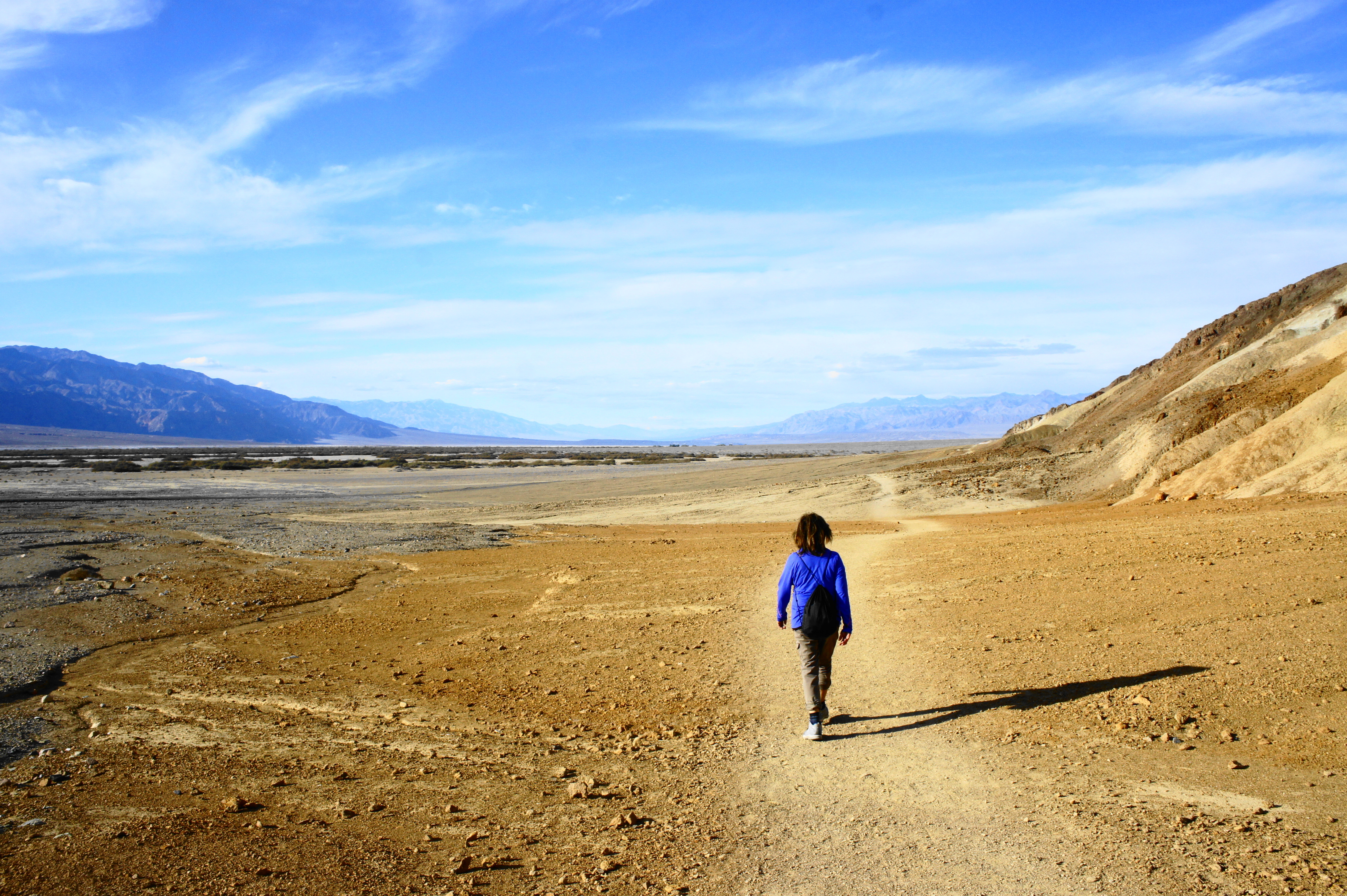
The Golden Canyon Trailhead, a paved parking area just off Badwater Road, is situated at the confluence of the narrow wash with the broad and vast Death Valley, producing a small alluvial fan that is typical of the region. Begin by following the largely level Golden Canyon Trail as it follows the snaking wash through a deep cut in the Black Mountains. The canyon narrows immediately, exposing a section of the 5,000-foot thick Furnace Creek Formation, the dominant rock layer in this region. The fine narrows here are reminiscent of those elsewhere in the park, such as Fall Canyon and Natural Bridge Canyon.

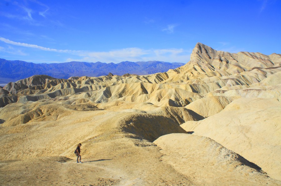
At about 150 yards, mount a minor obstacle, then continue east as the canyon opens up, revealing saffron-colored crags on the left and a multihued uplift on the right. Tracing the wash bed, views of Death Valley and the Panamint Range to the west begin to dissipate but are replaced with the first look at the ruddy, iron-oxidized cliffs to the east. But the predominant feature as hikers bear farther up the trail is the chalky yellow badlands that produce an alien-like landscape, one of the most iconic scenes in Death Valley National Park.

A multitude of side canyons on the left entice hikers to take a brief detour: one particularly striking wash at around the ½-mile mark leads through the mudstone badlands to a cliffside with golden- and champagne-colored hues.


Further up the trail, the canyon forks at 7/10 mile; stay right in the broader wash. Minutes later, the walls narrow again, revealing uplifted and tilted layers, the product of millennia of tectonic activity. At the one-mile mark, the Golden Canyon Trail leaves the wash and bears right at a signed junction. To complete the one-mile round-trip detour to Red Cathedral, however, stay left in the wash, continuing amid the badlands for a half-mile.
At 1.25 miles, the canyon splits again; stay left on the broader path, after which the route begins to do its first real climbing. At 1.4 miles, stay right, then enter a short and narrow slot where the walls narrow significantly. A few minor obstacles require some careful maneuvering, but most hikers will be able to negotiate the thin passage to Red Cathedral. At one point, hikers pass the remains of an old rusty ladder.


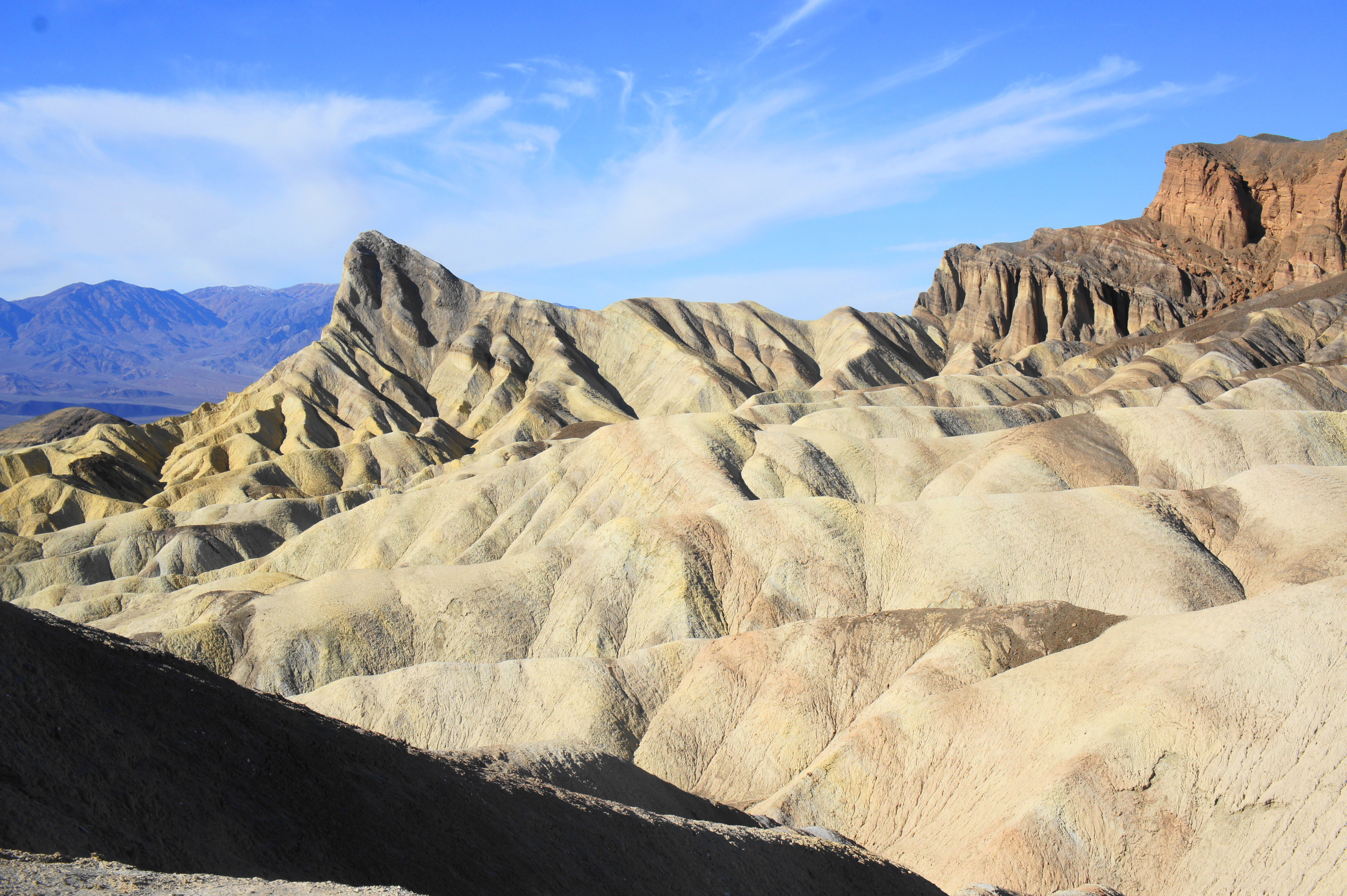
Finally, at 1.5 miles, the canyon opens up to reveal an amphitheater of fire-colored rock towering hundreds of feet high: this is Red Cathedral and the end of the half-mile spur.


Red Cathedral to Zabriskie Point (2.5 miles)
After taking in the views in this scenic corner of Golden Canyon, head back the way you came, weaving through the narrow notch then back to the Red Cathedral Junction, where the Golden Canyon Trail continues left, climbing up into the chalky badlands. To this point, the main trail has made relatively limited elevation gain (about 200 feet), but the ensuing section makes up for lost time, climbing a grueling 300 feet in less than a quarter-mile.

Ascending the lumpy badlands, hikers get their first look at the imposing face of Manly Beacon, an iconic touchstone of many Death Valley photographs. The tower is named for William Lewis Manly, a prominent 19th-century pioneer and gold prospector who passed through the region in 1849 as part of the expedition that gave Death Valley its name. (Note: Lake Manly, the prehistoric body of water that once covered this area, is also named for the same man.)

As hikers approach Manly Beacon, some of the hike’s best views unfold to the west, overlooking Golden Canyon and an amalgam of colorful badlands, with Death Valley and the Panamint Range reemerging in the distance. These terrific vistas help ease the difficulty of the steep ascent.


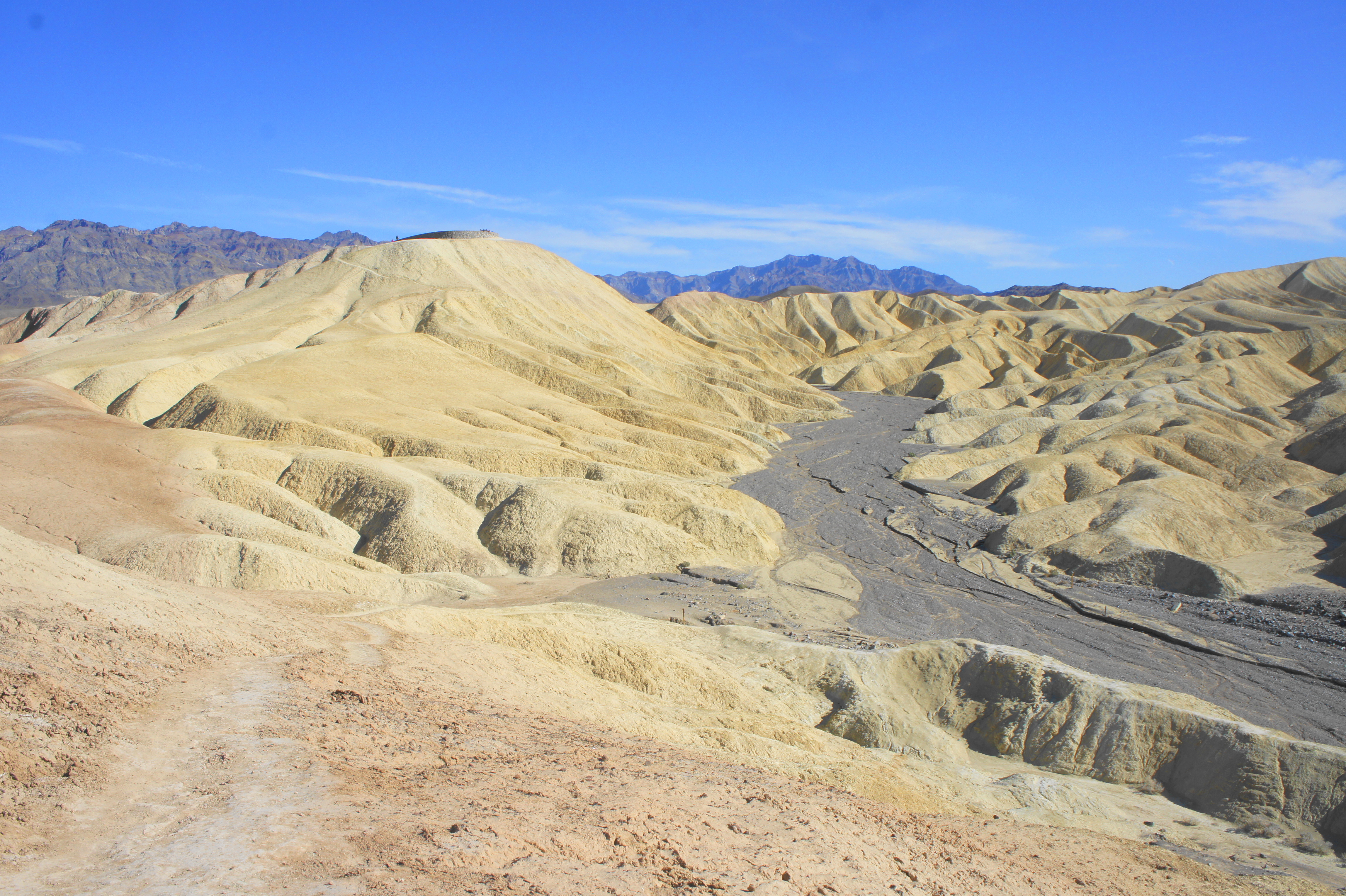
At 2.3 miles, with Manly Beacon towering above, the incline eases and the Golden Canyon Trail crests a ridgeline, revealing the first views of the next drainage to the south: Gower Gulch and its various corollaries. After a brief descent, the trail climbs again, then clears another low ridge before gradually dropping into another alien-like landscape of wispy badlands.

At 2.75 miles, bear left at Badlands Junction, continuing eastward on the Badlands Loop Trail. (Note: Those pursuing the shorter version of the Golden Canyon-Gower Gulch Trail Loop can continue straight to shave off around three miles of the hike.) After the fork, the path climbs again, affording excellent views of Manly Beacon to the northwest. This is one of the most spectacular sections of the hike.

Ahead to the east, hikers also get their first views of Zabriskie Point, the popular roadside viewpoint that is the next destination on the hike. After snaking around barren drainages (there is virtually no vegetation in the badlands), the trail descends into the wide Gower Gulch drainage. Take a hard left at the Zabriskie Point Junction, following the side wash to continue to Zabriskie Point.
In the next half-mile, the trail gradually climbs out of the wash and follows the trace of an old mining road up to the busy parking area for Zabriskie Point. From here it is a short, paved climb to the viewpoint.


Zabriskie Point, aside from sporting beautiful views (particularly at sunset), has a storied and eclectic history. Several movies were shot here, including a scene from Stanley Kubrick’s Spartacus (1960) and the namesake Zabriskie Point (1970), and the view from here features prominently on the cover of U2’s time-tested album The Joshua Tree. Famed French philosopher Michel Foucault also once claimed that his 1975 acid trip at Zabriskie Point was the best experience of his life. Today, alas, you are far more likely to see gads of ordinary tourists than philosophers and rock stars.

Zabriskie Point to Golden Canyon Trailhead via Gower Gulch (3.6 miles)
Having covered more than half of the trek and all of the absolute elevation gain, it’s time to make your way back down toward Golden Canyon Trailhead. From Zabriskie Point, retrace your steps to the parking area, then bear left on the connecter trail and follow it for ½ mile back to Zabriskie Point Junction. Instead of climbing the path leading up into the badlands, stay left and enter the broad dry wash of Gower Gulch. Here the Badlands Loop Trail continues downstream for 8/10 mile to the next junction.
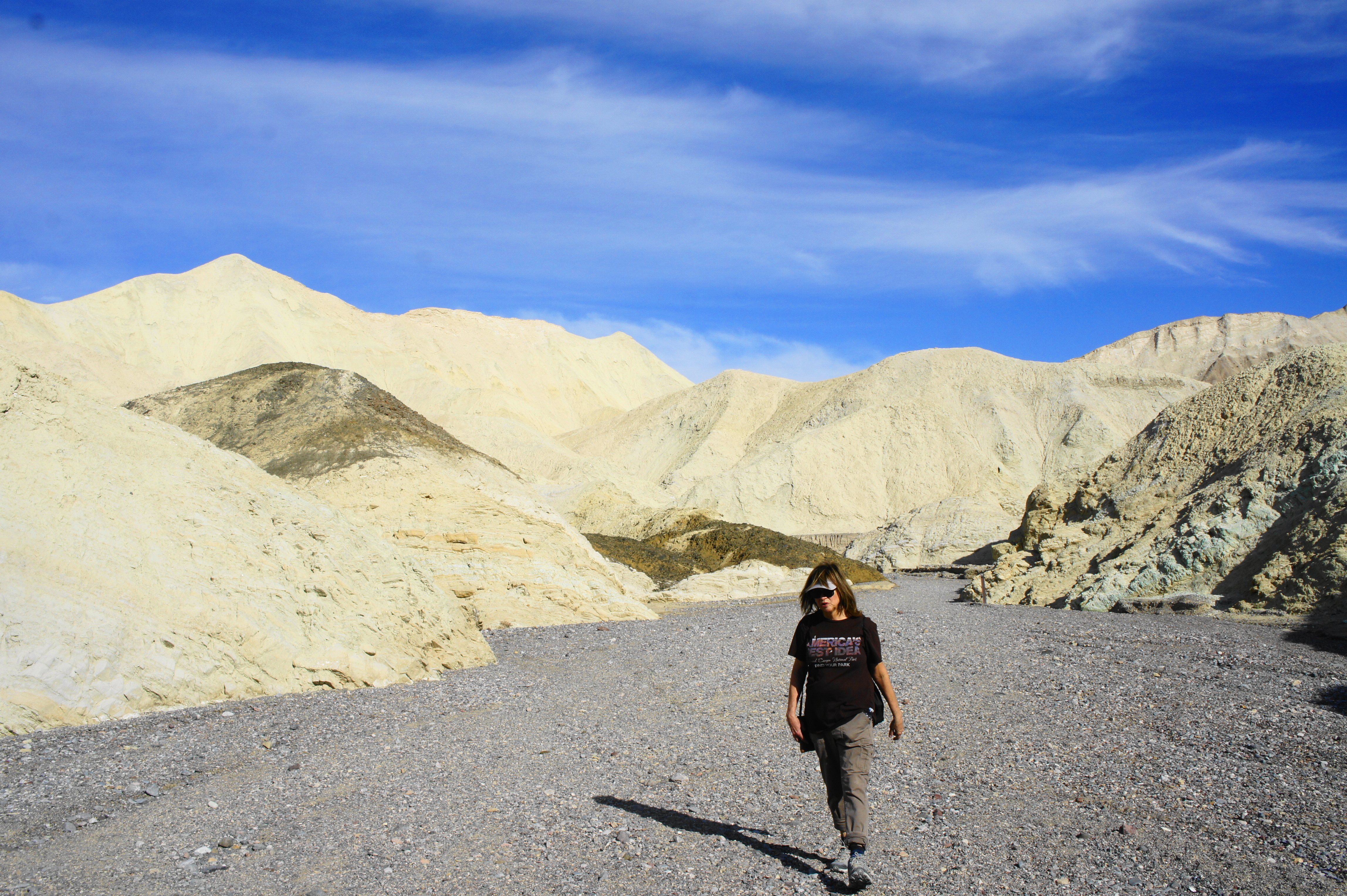
This section is undoubtedly the dullest portion of the hike, but it is straightforward, downhill, and features the gradual return of hearty vegetation that begins to pop up along the flanks of Gower Gulch. At 5.25 miles, a large side drainage enters from the left. Stay straight, continuing to Gower Gulch Junction at 5.4 miles.

Stay straight again at the fork, following the Gower Gulch Trail, as the gulch passes a clumpy chocolate-colored peak on the right. At around six miles, the route becomes considerably more scenic as the badlands fade and are replaced by high, multicolored walls. At a sharp left-hand bend, one can spot a man-carved window in the cliffs on the right: this is an adit, an entrance to an old borax mine that is horizontally carved.
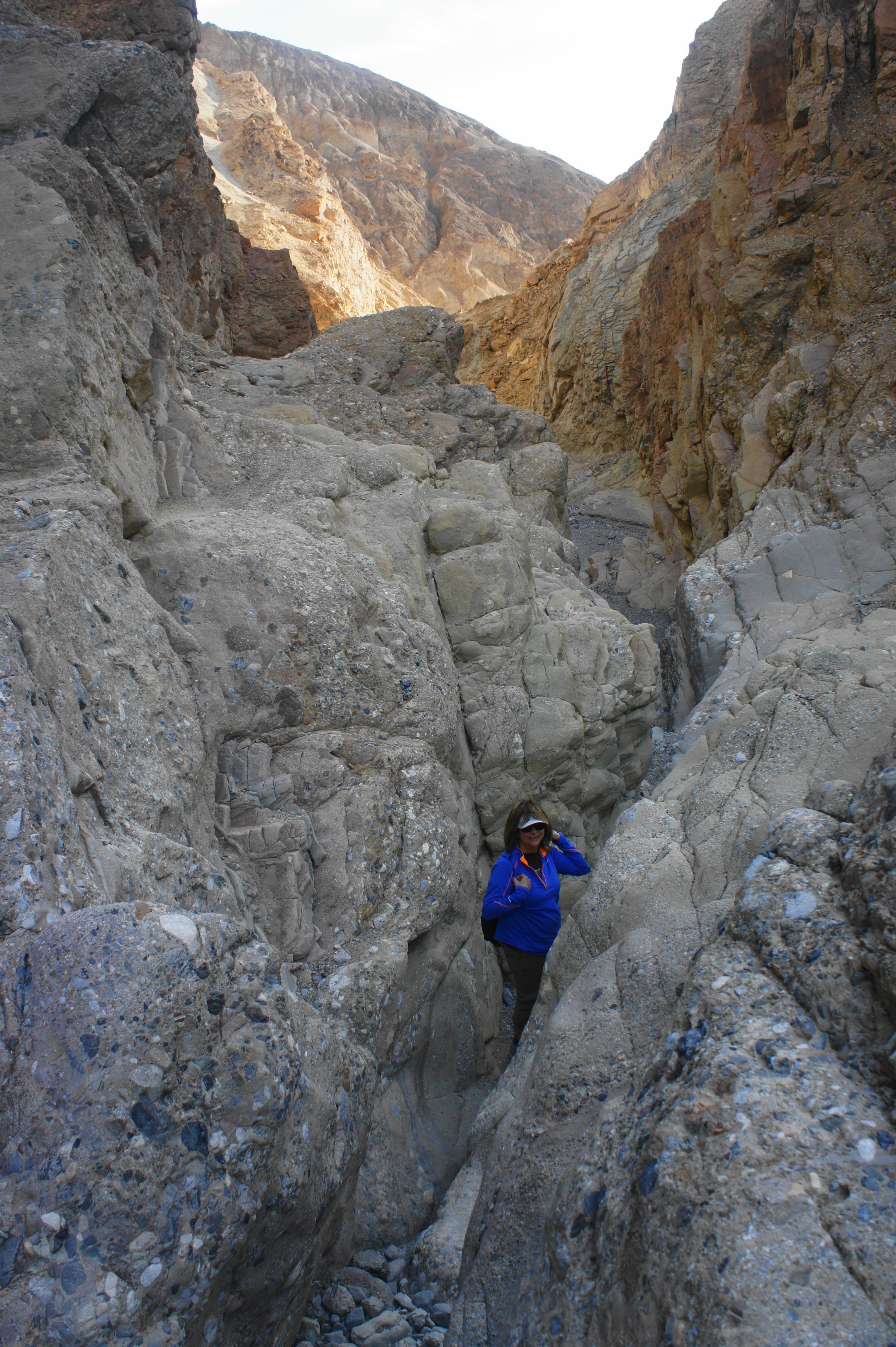
Just beyond, Gower Gulch narrows significantly, and hikers are greeted with a fun descent through a spiraling slot, one of the highlights of the trek. After another flat section, the wash drops abruptly at a 25-foot dryfall, emptying out into Death Valley, a dramatic end to Gower Gulch. Here the trail leaves the wash and skirts the cliffside on the left, revealing broad valley views again. From here the Gower Gulch Trail bends northward and hugs the western flank of the Black Mountains for nearly a mile. Ups and downs through side drainages and over low ridges finally lead back to the Golden Canyon Trailhead, culminating a 7.6-mile stem-and-loop hike.


Hikers walking at an average pace should allot between 4-6 hours for this hike, including the two spurs to Red Cathedral and Zabriskie Point. Hiking early or late in the day will help avoid crowds, although hiking in the early morning will mute some of the colors as the sun remains behind the Black Mountains.

Pingback: Top 10 Hikes in 2020 | Live and Let Hike
Hello. I’m trying to locate the mountain area and image used by Ansel Adams titled ‘ Manly Beacon in Death Valley, CA’, however, I cannot find that image or location in the area of Manly Beacon Death Valley, CA. Does anyone have actual personal photos from actually being at the Manly Beacon Death Valley Mountain? Your assistance is greatly appreciated. I look forward to hearing from you soon.