
Great Basin National Park in eastern Nevada has three main claims to fame, including: 1) the lowest visitation of all national parks in the contiguous United States; 2) the only glacier in Nevada; and 3) large concentrations of bristlecone pines, thought to be the longest-living tree species on the planet. Being one of the most popular hikes in an otherwise scarcely-visited park, the featured hike does not necessarily offer the solitude offered by #1, but its popularity is owed to its proximity to #2 and #3. The Bristlecone-Glacier Trail leads to an excellent stand of trees that predate the Roman Empire before ending in a glacial cirque at the base of Wheeler Peak (13,063’), the highest mountain contained entirely within the state of Nevada. In this description, I combine this one-way trek with a brief circuit on the Alpine Lakes Loop Trail, which passes two glimmering pools—Stella and Teresa Lake—nestled deep in the Snake Range. Together this combination of trails makes for a fine half-day hike in Great Basin.


The hike
The featured hike begins at the end of Wheeler Peak Scenic Drive, which winds for 12 miles and climbs to more than 10,000 feet above sea level. The parking area at the Bristlecone-Alpine Lakes Trailhead is one of the most popular in Great Basin National Park, while the hike’s proximity to the Wheeler Peak Campground brings a steady stream of visitors on summer weekends. (Note: Otherwise, the crowds are far more manageable. Remember: Great Basin is the least visited national park in the contiguous US.)
A large wayside and map marks the start of a well-kept trail leading south from the parking lot. Follow the wide path as it crosses a bridge over a minor creek, then stay right as the short, ADA-accessible Island Forest Trail bears off to the left. Continue as the broad trail weaves through a dense forest of pines and firs (these are largely not bristlecones) to a second junction at 1/10 mile. Bear right on the Alpine Lakes Loop Trail, heading for the two lakes first before hitting the bristlecone grove and glacier.
Alpine Lakes Loop section (2.0 miles)
The Alpine Lakes Loop Trail remains relatively level as it crosses a wooden boardwalk and bridge at ¼ mile, then climbs amid patches of aspens and occasional clearings with views of Wheeler Peak—a popular destination in itself. After a series of mountain-building events formed the Snake Range during the middle Cenozoic Era, Ice Age glaciers and erosion sculpted Wheeler Peak into the jagged behemoth of today.

At about 9/10 mile, a trail comes in from the right: this is the Wheeler Peak Summit Trail, which begins partway down the Wheeler Peak Scenic Drive from the Bristlecone Trailhead. Stay left, then left again at a subsequent junction: here the Wheeler Peak Trail bears off to the right, continuing up a steep slope toward the summit. Bearing left brings one to the shores of Stella Lake—about one mile from the trailhead.

Stella Lake has arguably the more impressive views of the two lakes, with the still waters abutting a steep scree slope, with Wheeler Peak in the distance. The lakeshore is easily approachable and in exposed sun. In dry years, however, expect the water levels to be rather low (although not as low as nearby Teresa Lake).
Moving on from Stella Lake, hikers continue south on the Alpine Lakes Loop Trail, which gradually descends in fits and starts through thickets of pines. At 1.8 miles, the trail descends to Teresa Lake on the right. The lake is hit-or-miss, depending on levels of precipitation in the preceding months. In dry years, the lake shrinks to barely a puddle. In wet years, the basin fills with beautiful, turquoise waters that are alluring and photogenic. (Note: Winter 2019/2020, unfortunately, produced only about 60% of the average snowpack, so I got the former.)

From Teresa Lake, it is a short but rocky climb to the junction with the Bristlecone Trail.
Bristlecone – Glacier Trail section (1.7 miles)
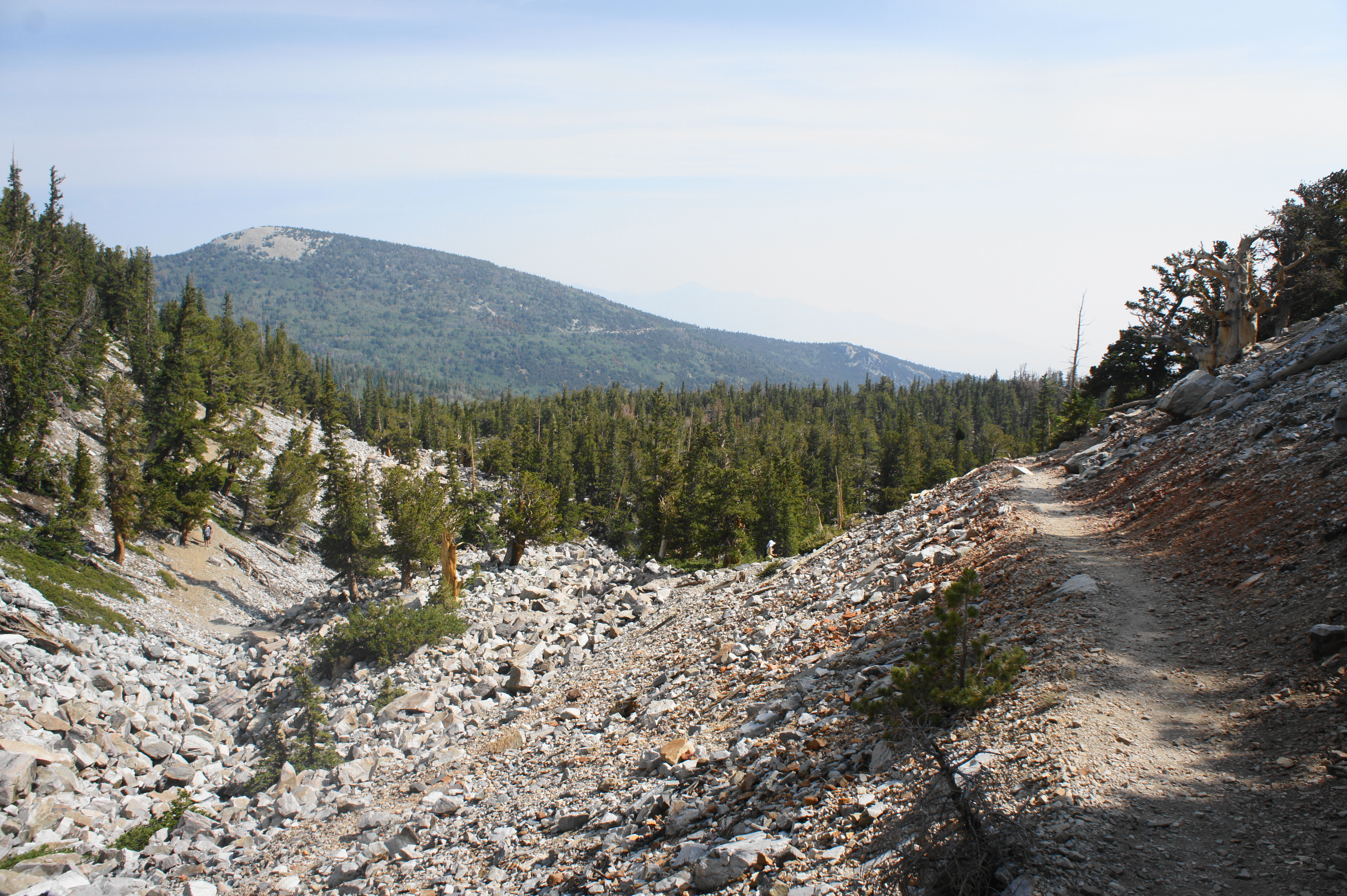
At the fork, turn right and follow the east-bound trail along a north-facing slope with emerging views across Lehman Creek Valley toward Bald Mountain (11,562’) and Buck Mountain (10,972’). After a steady ascent, the trail rounds a corner at 2.3 miles and enters a side drainage that includes distant views of Brown Lake, a small pond in the moraine below. From here the Bristlecone Trail drops to clear a rock-choked wash and then switchbacks right, climbing more steeply along the adjacent slope.
At 2.7 miles, the Bristlecone Pine Grove Interpretive Trail bears off to the left. This short spur is well-worth the detour, passing through the heart of one of the world’s oldest groves of bristlecone pines. Regular signs point out features of these magnificent natural wonders: many of the gnarled trees date to more than 3,000 years old, alive since before the days of the Roman Empire, Cleopatra, or Alexander the Great.

Towering (living) bristlecone 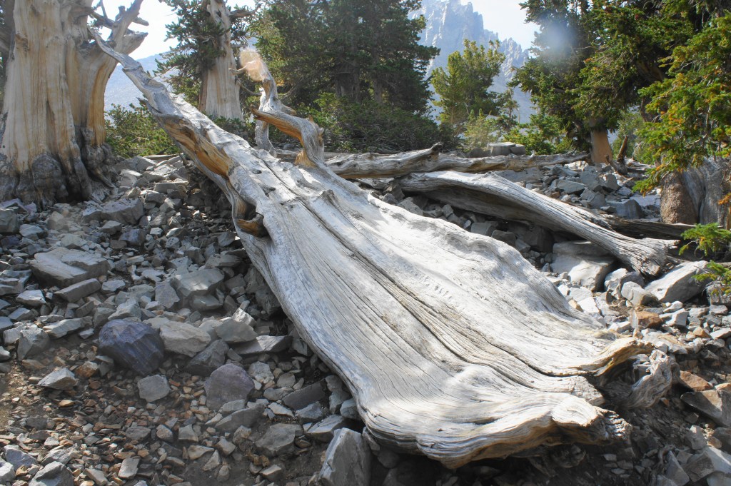
Epic (but fallen) bristlecone trunk
Why such longevity? Counterintuitively, the harsh conditions in which Great Basin’s bristlecone pines are found—usually just below treeline on cold, windswept slopes—compels the trees to grow very slowly, which creates very dense bark that is more resistant to the elements (wind, water, insects).


Follow the meandering interpretive trail as it passes a handful of epic bristlecones before it empties out again at the main trail. The route beyond turns into the Glacier Trail—bear left to climb above treeline and continue to the base of Rock Glacier.
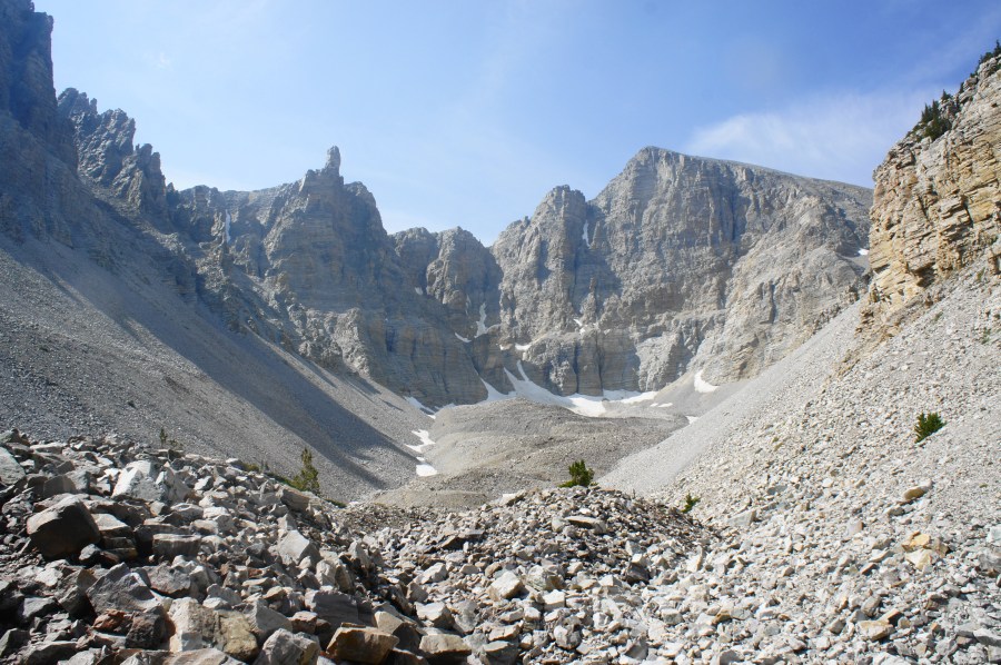
Depending on the season, the trail beyond may be impassable due to snow. But late-summer travelers can make their way to trail’s end with relatively little trouble (although the glacier, of course, is not quite as impressive sans snow). At 3.0 miles, the trail reaches a viewpoint with an interpretive wayside for Rock Glacier. The glacier has formed a deep cirque, a hollow, snow-sculpted valley rarely found in the Basin and Range area of the West. Ahead, the tall, triangular summit is Wheeler Peak; the unfortunately-named Jeff Davis Peak (12,771’) dominates the view to the south.

While some hikers turn around at the wayside, the trail continues onward, first climbing a pair of switchbacks before leaving the trees behind and cutting across the rocky moraine. Follow the circuitous path as it bounds up and over a series of hillocks before ending abruptly at a sign that reads “Rock Glacier – Elevation 10,800 Feet.” This is the terminus of the Glacier Trail.

Return to trailhead (2.1 miles)
When you’re ready to leave the picturesque cirque, return the way you came, passing the Bristlecone Pine Grove and arriving again at the turnoff to Teresa Lake. This time stay right, descending the final section of the Alpine Lakes Loop Trail as it returns to the trailhead. At 5.7 miles, stay right at the fork, then bear left at the junction with the Island Forest Trail. After traversing the final bridge, hikers return to the parking area having completed a moderately difficult—but immensely scenic—5.8 mile hike.


We love this park! I was shocked to see the lack of water in the lakes. Thank goodness we had full, beautiful lakes during our fall visit. The Bristlecone Forest in GBNP is the prettiest we’ve ever seen. We’ve been to many Bristlecone areas but the tree trunks here are so spectacular. Looks little smokey.
It was indeed sad to see the lakes so low, and the smoke from the California fires was present but fortunately relatively muted the day I visited.
Pingback: Top 10 Hikes in 2020 | Live and Let Hike
Pingback: Methuselah Trail (Inyo National Forest, CA) | Live and Let Hike