
Winter and early spring is far and away the best time of year to hike in the East Bay, when temperatures are good and the rolling hillscapes—typically brown, dusty, and dry in summer—are lush and verdant. The jade-colored hues in springtime make the Diablo Foothills in the Walnut Creek area arguably a fair match to the beauty of Marin, Point Reyes, and other, more popular Bay Area hiking destinations. One local favorite is Shell Ridge Open Space, a 1,420-acre tract managed by the City of Walnut Creek that, despite never exceeding 1,000 feet, is perhaps more beautiful than the scrubby chapparal of Mount Diablo proper. The featured hike here—which begins and ends at Marshall Drive—climbs the rolling ridgeline of Shell Ridge, then drops to follow the oak-studded drainage of Indian Creek. All in all, this moderately-difficult hike clocks in at just shy of five miles across beautiful terrain.

The hike
Shell Ridge Open Space in Walnut Creek has a plethora of trailheads, but one of the most easily accessible is the Marshall Entrance at the end of Marshall Drive. (Note: Search “Indian Valley Elementary School” on your GPS.) There is plenty of street parking just before the trailhead, and an entry sign offers maps and information on the day use park. An intricate network of trails crisscrosses the Shell Ridge area; this hike covers much of the most interesting terrain, rising to scenic heights before dropping to the quiet and pleasant Indian Creek drainage.
From the trailhead, turn left immediately and climb the wide dirt track as it bends westward and reaches a six-way junction at 2/10 mile. La Casa Via, a residential street (with no trail parking) lies straight ahead, while the Briones-to-Mount Diablo Trail continues left, hugging a wooden fence. Hikers will want to bear right on the Ridge Top Trail (aka Ridge Trail). (Note: Alternatively, hikers can climb the more established road that leads up the southern slope of Shell Ridge to a water tank, but this is steeper and a little less pleasant.)

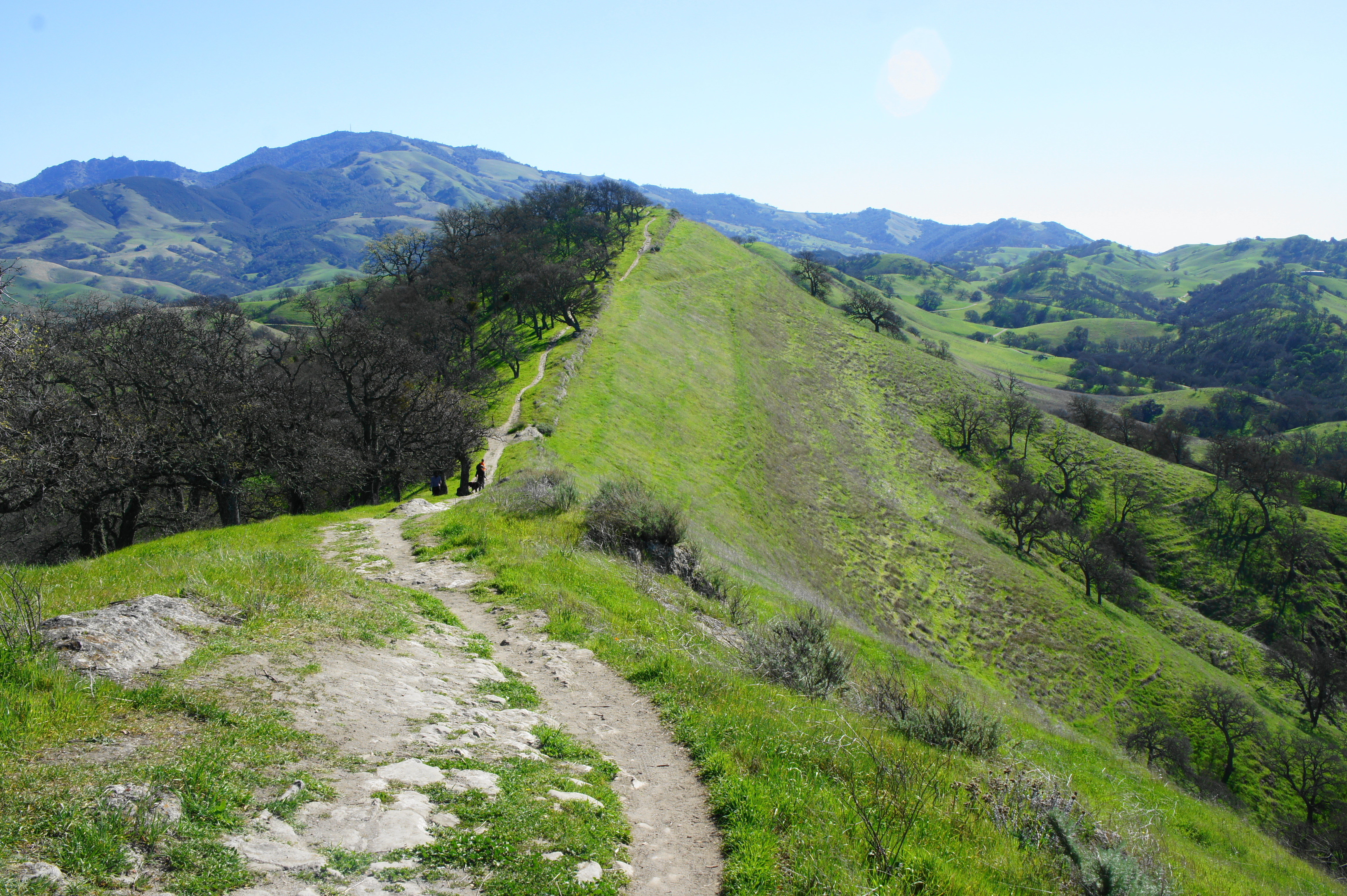
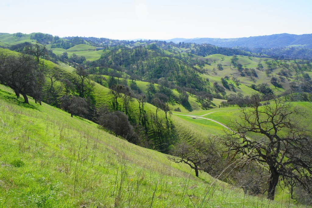
The Ridge Top Trail, a narrow and attractive singletrack, gradually ascends the north-facing slope of Shell Ridge, with the Corral Spring Trail visible below. At 6/10 mile, the trail rounds a right-hand bend and then climbs to crest the ridgeline, offering sweeping views southward across Joaquin Ridge and the broad valley beyond, with Las Trampas Ridge beyond. (Note: Here the route from the water tank enters from the right.)

Continue left, following a noticeable spine of protruding sandstone, which was thrust upward during the mountain-building event that created Mount Diablo some five million years ago. This area was once covered by sea, as noted by the sporadic presence of seashell fossils in the rock strata of Shell Ridge.

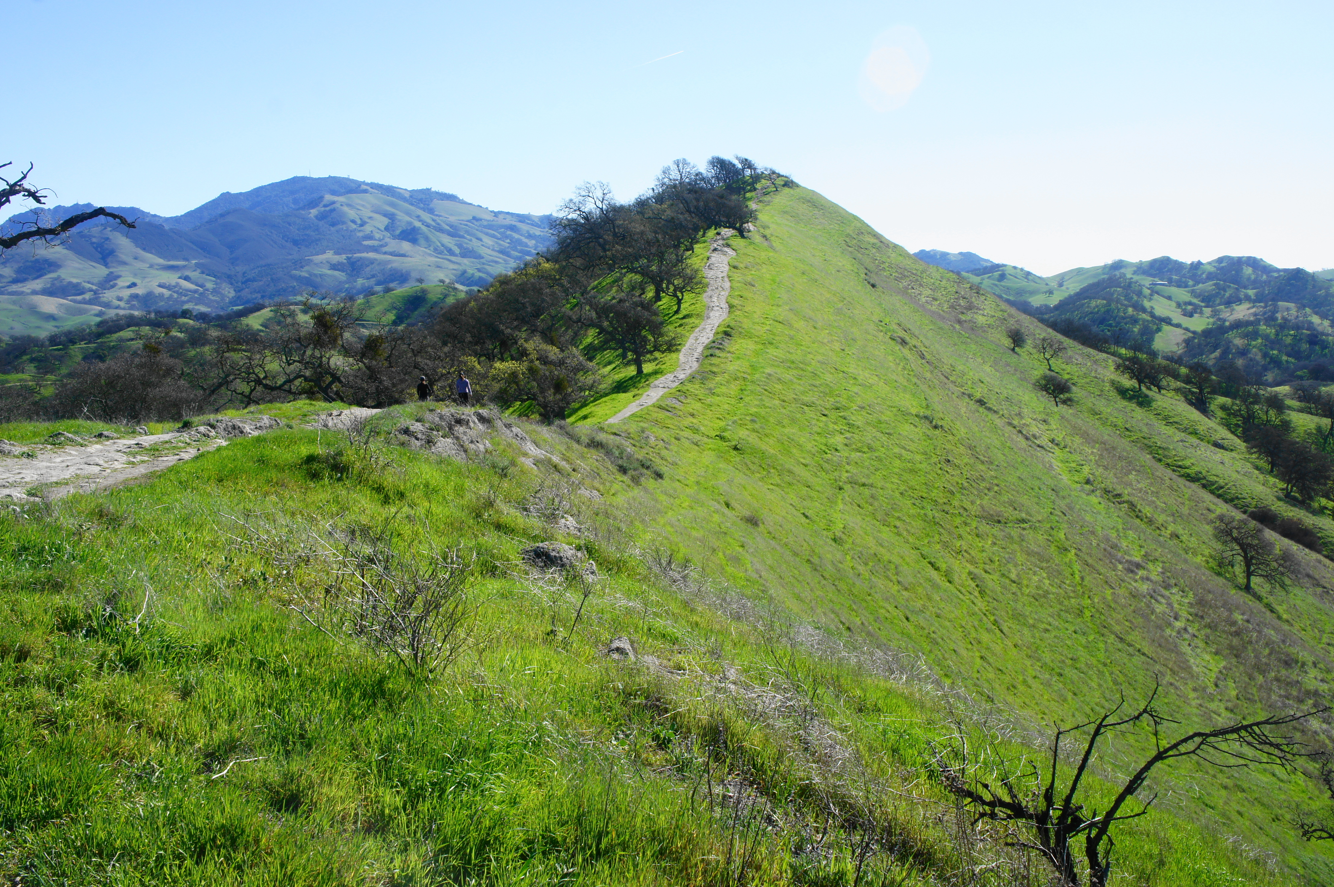
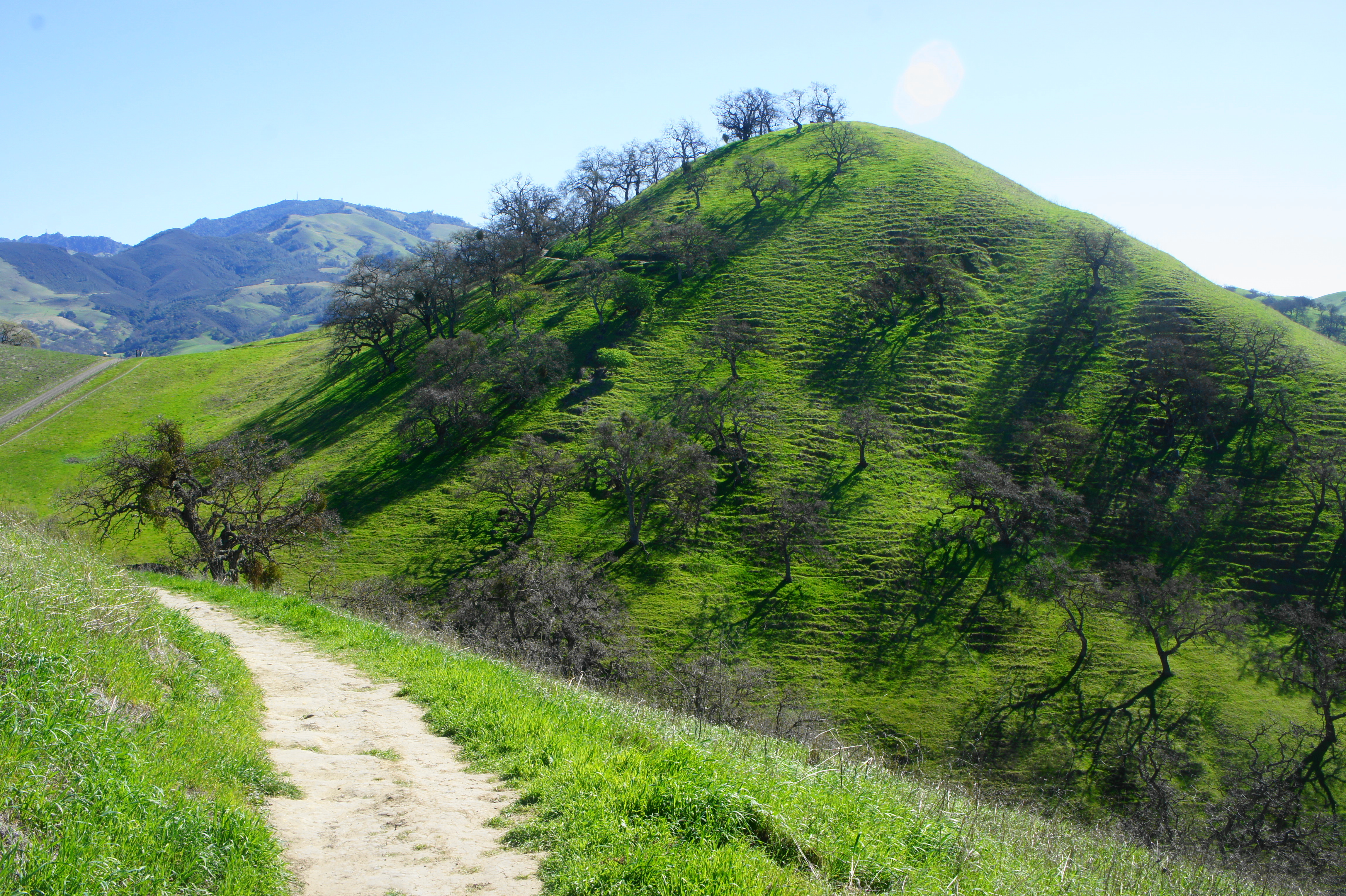
The Ridge Top Trail proceeds to climb steeply to the first of several summits at 8/10 mile, where a bench facing south offers an opportunity to catch your breath. Beyond this first hilltop is a second, higher summit, with even better views overlooking the Shell Ridge area to the south, Lime Ridge and Suisun Bay to the north, and imposing Mount Diablo to the east.
After this second summit, the trail drops to a marked junction at 1.2 miles. Bear left on the Ridge Top Trail continuation (heading right dead-ends at a third hilltop), then gradually descend the partly shaded hillside to Grinder Gap, where the trail intersects with several fire roads that include the Corral Spring Trail. Stay straight on the singletrack, which rises again and crests a high saddle at 1.8 miles, moving to the south-facing slopes of Shell Ridge.

Remaining largely in the sun, the singletrack gradually descends again to a drainage fed by Dry Spring, where there is a gate that acts as a cue for hikers to exit left. Here the Ridge Top Trail crosses the broader Costanoan Trail, then wraps 270 degrees around an oak-studded knoll, returning to cross Costanoan again at 2.3 miles. From here the Ridge Top Trail climbs steadily again, rounding a sharp left-hand bend, then over a pass to the hike’s high point (about 850 feet).

Mount Diablo 
Ridge Top Trail
Then it is back downhill again as the trail snakes eastward and south, passing under a set of power lines and encountering a water tank on the left. At 2.9 miles, the Ridge Top Trail ends; bear right on the Briones-to-Mt-Diablo Trail to continue west, en route back toward the trailhead.
Diablo Foothills from Ridge Top Trail 
Shell Ridge from the Briones-to-Mt-Diablo Trail
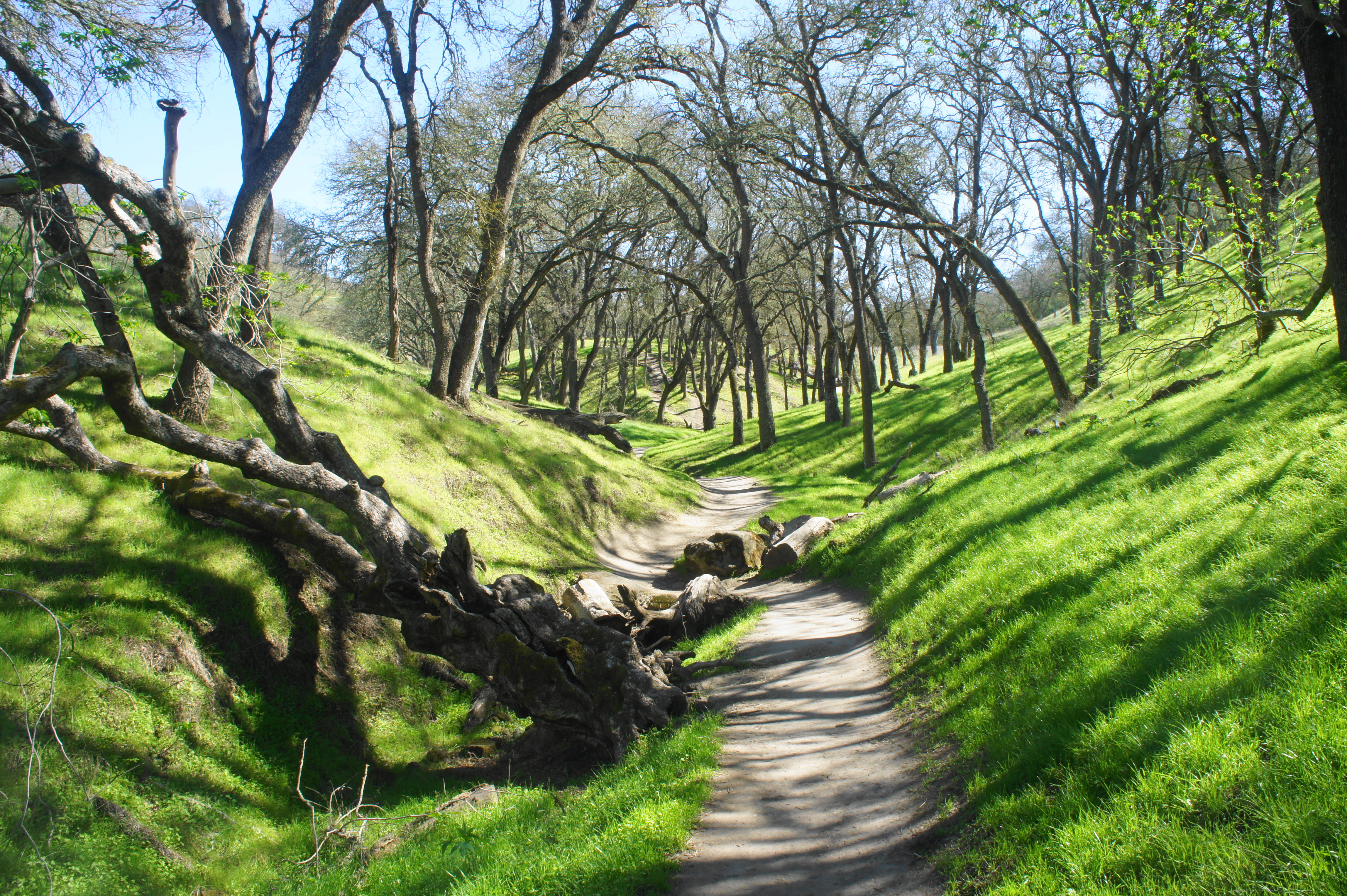
The wide Briones-to-Mt-Diablo Trail stretch is perhaps the least interesting stretch of the hike, but it does get progressively shadier as various oak trees fill in around the trail. Stay right at the fork at 3.2 miles, then right again at the junction with the Coyote Pond Trail, just past an open gate at 3.5 miles. After taking another right at the next fork, crest a low gap between drainages and look left for the Indian Creek Trail. This scenic path descends gradually to its namesake drainage, which is effectively dry most of the year but still beautiful in verdant springtime.

Stay on the Indian Creek Trail as it traverses a junction at Bramhall Pond (dry) at 4.4 miles, then continue as the drainage narrows and the trail increasingly spends time down in the ditch itself. At 4.5 miles, the path ascends a neatly-constructed staircase, with a bench at the top. From here the trail drops again to the wash bottom and follows it past a handful of protruding rock faces to another junction at 4.6 miles. Head right this time, exiting the wash on the popular Fossil Hill Loop Trail.
Take this wide double-track for roughly 200 yards, then bear left again on the Briones-to-Mt-Diablo Trail, which offers passage back to Marshall Drive. Stay left at the next two junctions, hugging the perimeter of Indian Spring Elementary, then return to your car at the start.
The 4.9-mile trail should take 2-3 hours and, despite some decent elevation gain and loss, is moderately difficult at worst.

Pingback: Top 10 Hikes in 2021 | Live and Let Hike
Hi, Thanks for this writeup. Our foursome did it yesterday (July 7, 2022). We definitely looked at the weather forecast out there because the heat can be brutal in the summer, but we picked a day when the forecast was for no more than high 70s. Anyway, appreciate your introducing us to this not-to-difficult hike. Wildflowers (except for a few poppies) are gone and the hills are turning brown, but even so, the views are wonderful.
Pingback: The Great Walnut Creek Dinner Crawl - Palo Alto Online
While this is a great hike year round please make sure THIS time of year to bring a lot of water, wear good sun screen, and maybe most important, watch out for Rattlesnakes, as there are a lot of them up here!