
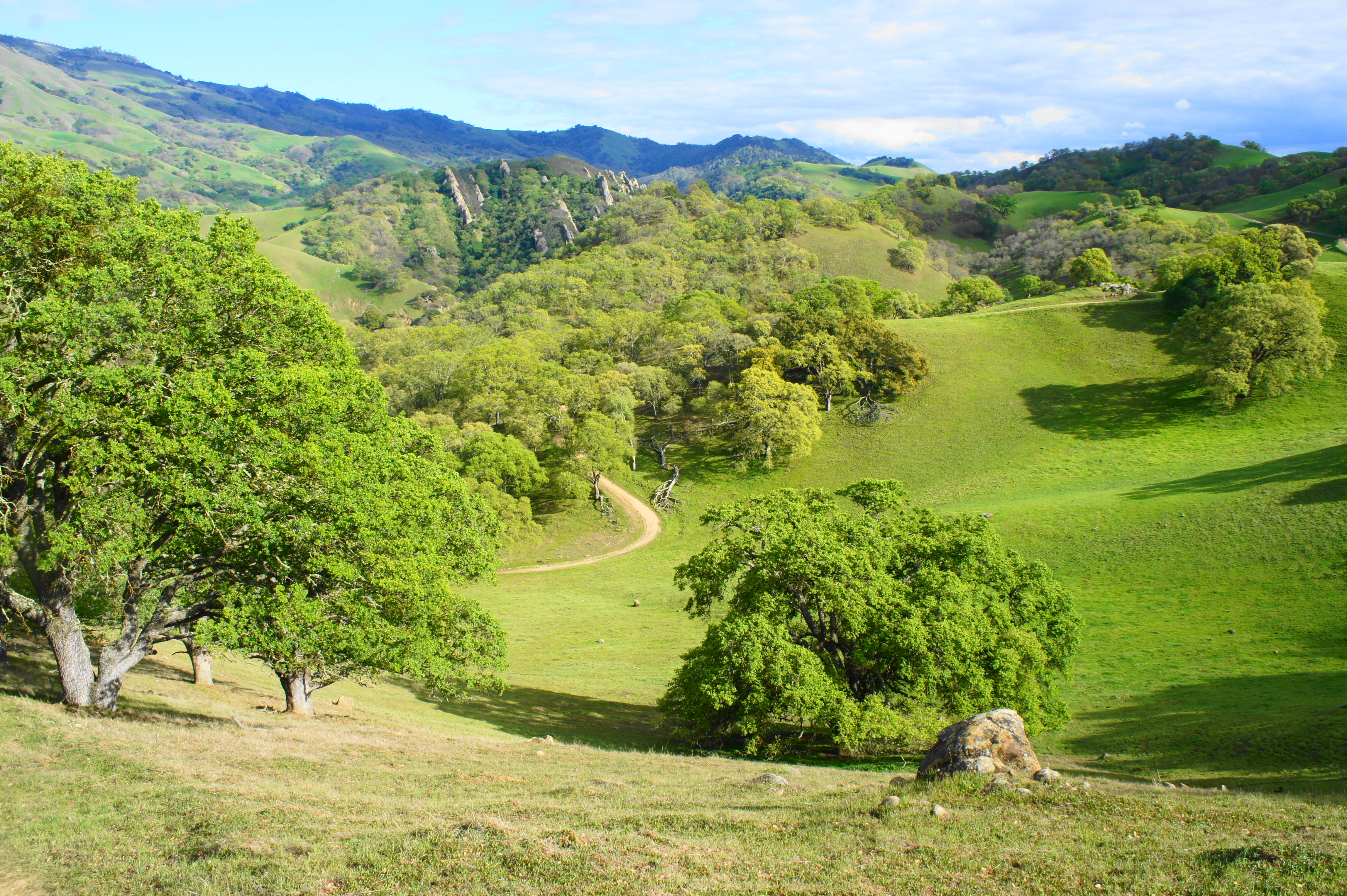
Despite being overshadowed—almost literally—by Mount Diablo (3,848’), Diablo Foothills Regional Park covers a surprisingly beautiful but low-elevation landscape in northern California’s East Bay. There is but one knoll in the park that rises above 1,000 feet, yet the oak-studded ravines, hidden valleys, and verdant hillsides—particularly alluring in spring—are beautiful nonetheless. A short drive from downtown Walnut Creek, parts of the park can be overrun on weekends, but the crowds thin as hikers venture into the hilly expanse. The below hike covers a nearly six-mile circuit, dipping briefly into neighboring Mount Diablo State Park and traversing canyons, oak-bay woodlands, and open pastures with several fine vistas throughout.
The hike
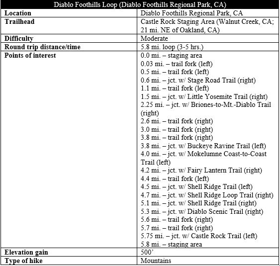
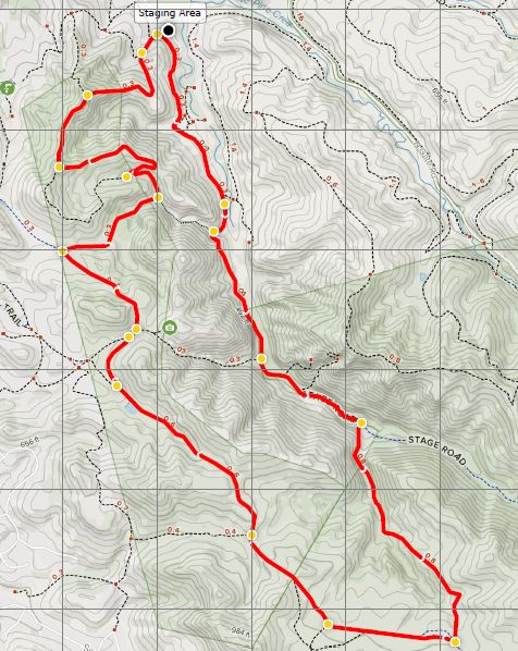
The loop hike begins and ends at Castle Rock Regional Recreation Area, an almost park-within-a-park and the most popular staging point for walks into Diablo Foothills Regional Park. (Note: See Google map here.) From Walnut Creek, follow Castle Rock Road to its end. Arrive early to get a parking spot at the small lot at Castle Rock; otherwise backtrack about ¼ mile to the much larger Orchard Staging Area. (Note: If parked at Orchard, follow the roadside trail to Castle Rock.) While most visitors come to Castle Rock for the picnicking, softball/volleyball, or the pool, there are also several hiking trails taking off from the parking lot.
From the Castle Rock parking area, find the marked single-track heading up the western slope. After 50 yards, this merges with a wider track—the Castle Rock Trail—which bears southward for the next half-mile. Follow this broad path as it hugs the hillside, a couple dozen feet above the crowded valley below. The hills on both the near and far side are part of the broader Shell Ridge, composed of rock that was thrust upward as part of the Mount Diablo uplift a mere five million years ago.

As the Castle Rock Trail proceeds, Pine Canyon narrows ahead, and the open hillsides give way to denser vegetation. After passing through a gate at 3/10 mile and a trail fork at ½ mile (stay left), hikers should bear straight on the Stage Road Trail as it passes through another gate and briefly leaves the confines of the park. As the once-rolling hillsides evolve into jagged canyon walls, another track comes in from the right, and then the Stage Road Trail intersects with the Buckeye Ravine Trail at 7/10 mile. Stay left again.
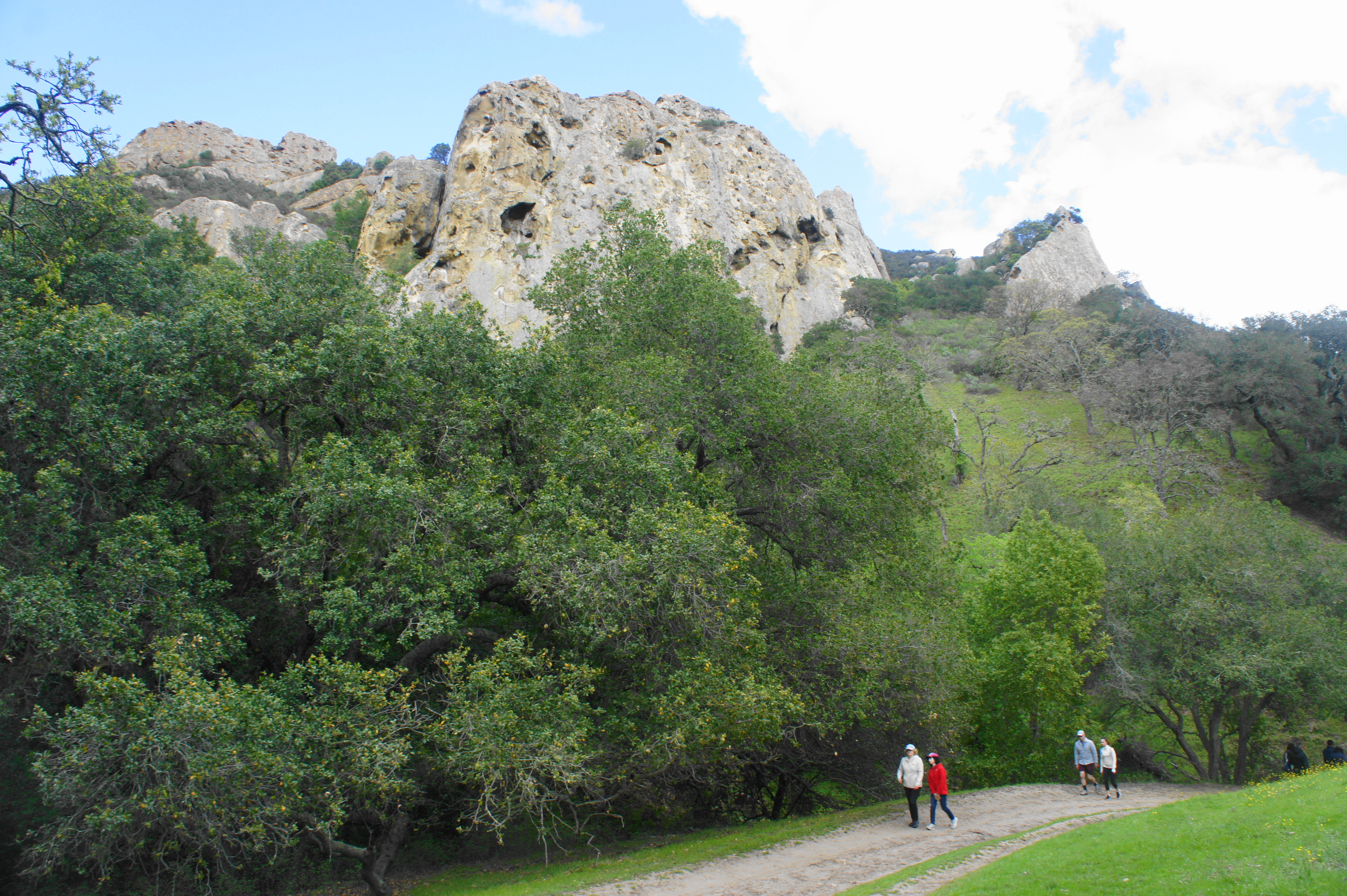
Having now reentered Diablo Foothills Regional Park, the trail passes a dry reservoir along Pine Creek on the left, and hikers can begin to spot the towering outcrops ahead—these are the official Castle Rocks, a popular climbing area situated just within the boundaries of Mount Diablo State Park.
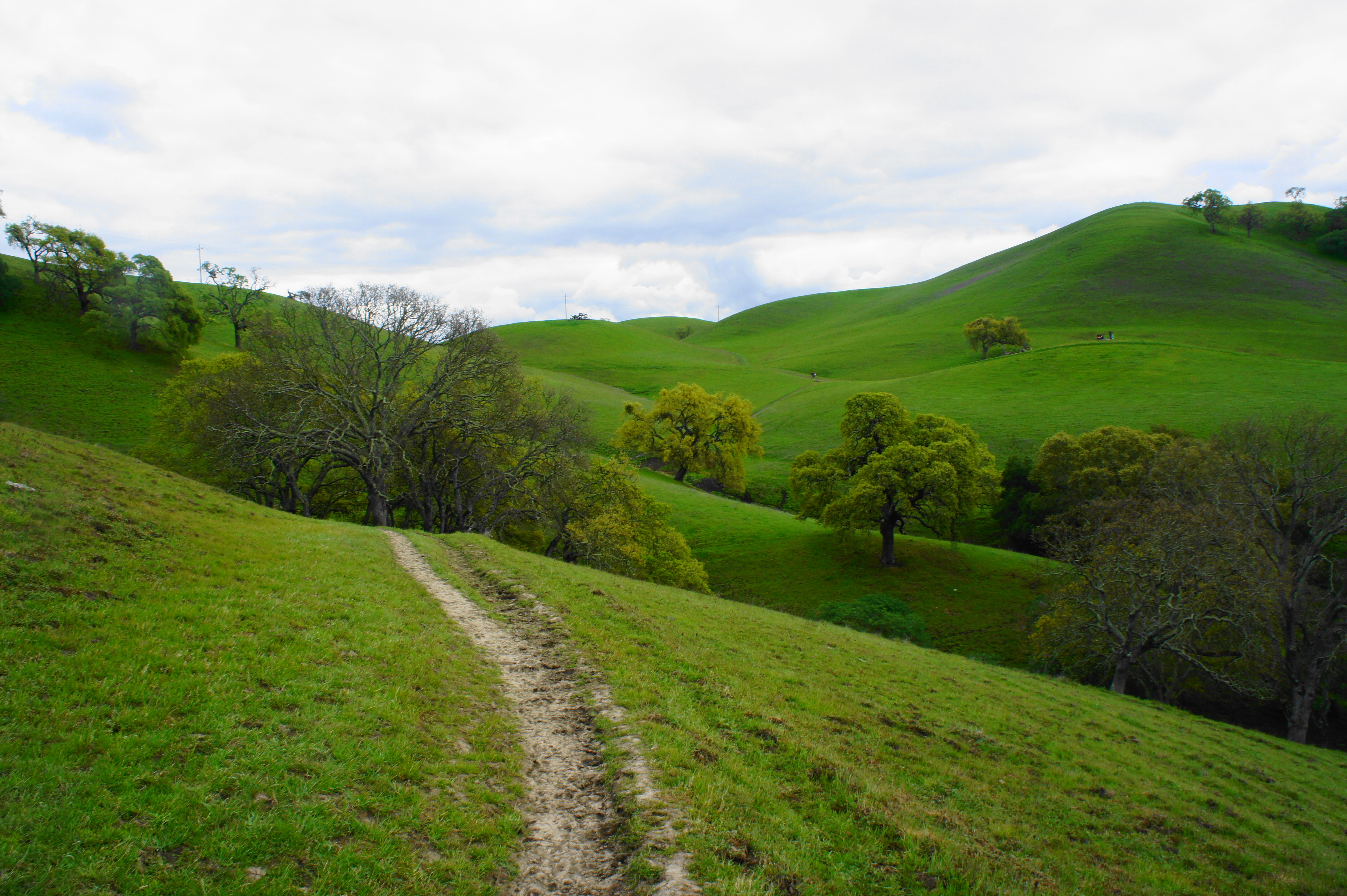
At 1.1 miles, the Stage Road Trail intersects with the Buckeye Ravine Trail again. Stay left and follow the wide track as it passes a series of pleasant meadows and oak groves. The trail twice crosses Pine Creek, which is usually very low volume. Finally, at 1.45 miles, just before another oak-studded grassland, look for a well-worn single-track that bears off to the right and skirts the edge of the thicker woodland to the south. This is the Little Yosemite Trail, your cue to exit Pine Canyon.
Follow the Little Yosemite Trail as it passes into Mount Diablo State Park and skirts a craggy ravine on the left. The path eventually crosses a small creek, and the scenery briefly opens up into a quiet, narrow valley. At 1.9 miles, the trail veers away from the creek and climbs a rocky ridge. From here the woods eventually fade away, and the Little Yosemite Trail mounts a grassy slope, revealing views back toward Pine Canyon, east to Mount Diablo, and west across Shell Ridge. This is a particularly scenic stretch of the hike, and the views continue as hikers bear right on the Briones-to-Mount-Diablo Regional Trail at 2.25 miles.

Little Yosemite Trail 
Pine Canyon from afar
From here it is westward ho! Traverse relatively level terrain, surrounded by hillsides that appear to be straight out of Scotland or Ireland. You are likely to spot animals grazing—at least the resident cattle population, the park’s natural lawnmowers.

At 2.6 miles, a spur trail leads south to the base of what is called the China Wall—a peculiar line of jagged stones that I suppose sort of resembles the not-so-natural Great Wall of China—for which I assume it was named.

Briones-to-Mount-Diablo Trail 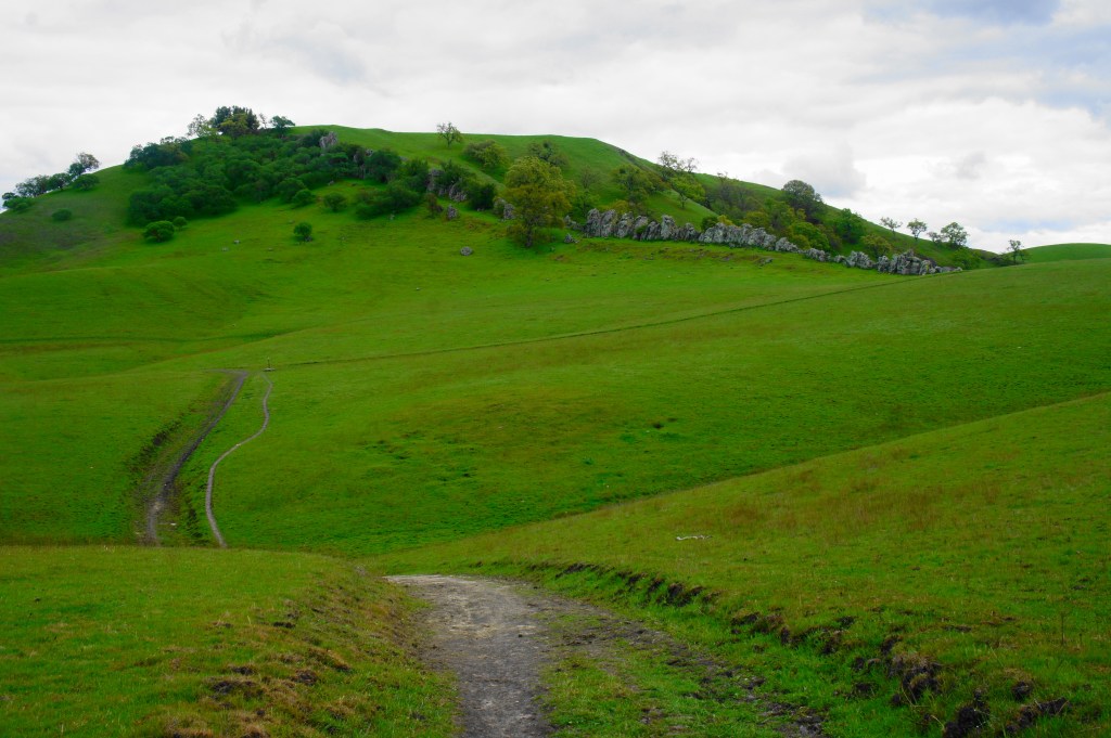
China Wall on the right
Stay on the main track as it climbs to clear a grassy hillside, revealing northward views beyond. After passing through a cattle guard, the route drops to a low saddle, where a connector trail bears off to the left. Then the Briones-to-Mount-Diablo Trail climbs again to a high gap with excellent views of Mount Diablo, the massive behemoth that is, though not the tallest, perhaps the most famous peak in the East Bay.

The onward path then descends gradually into a splendid, nearly tree-less valley, a true gem of the Diablo Foothills. After passing a popular watering hole for cows on the left, the valley opens up into a wide basin, and a series of intersecting trails come into view. Stay right on the main track, which wraps around to the northeast of the basin, leaving the valley behind after a short stay.


As the trail climbs mildly to a low gap between hills, stay right at the first junction, then left at the second, now following the Buckeye Ravine Trail back toward Castle Rock. At the fork at 4.1 miles, the shortest way is to continue right on the Buckeye Ravine Trail, but this involves an unnecessary descent and climb. Instead stay left on the Mokelumne Coast-to-Crest Trail, which is relatively level. The trail approaches a gate and the western boundary of the park, but stay right just before the gate, following the Fairy Lantern Trail eastward along the base of a tall hillside.
The wide track gradually drops into a shady ravine, with stony protrusions visible off to the left. Stay left at the next fork, then one faces a choice: continue right on the Fairy Lantern Trail for a mild descent back to the Castle Rock Trail, or head left for an added adventure—the scenic route back to the start. I highly encourage heading left, as the roundabout route is worth it for the fantastic views of Mount Diablo, Walnut Creek, and surrounding landscape.

Bearing left on the Shell Ridge Trail, one faces an option again roughly 250 yards later. Both trails leading from this fork end up in the same place, but heading right on the Shell Ridge Loop Trail is slightly shorter and more scenic. Climb the oak-studded hillside, steeply in places, before cresting the ridge at 5.1 miles, where the Shell Ridge Trail reenters from the left.

Mount Diablo and Eagle Peak from Shell Ridge 
Looking back at Castle Rocks and Pine Canyon
From here, bear right—northward—on the Shell Ridge Trail, which drops, then climbs again along a scenic ridgeline. To the south and east, one can spot the neatly parallel outcrops at Castle Rocks, with the long arms of Mount Diablo beyond. Westward, hikers can see across Walnut Creek to the Briones Hills. And northward, peer across the valley toward Suisun Bay and the Carquinez Strait, with the high peaks of the Mayacamas Mountains visible on the horizon.


At 5.25 miles, the climbing is done, and the only way back is down. Bear right on the sharply descending Diablo Scenic Trail, a wide but brutally steep track that sheds 300 feet in just over 1/3 mile. After a dogleg left, the incline eases, and hikers approach another junction. Bear right, then right again at the penultimate fork, situated behind the Park Office, a stone’s throw from the staging area. Bear left at the final junction—which was the initial approach from the parking area hours ago—and return to the trailhead.

All in all, this loop hike clocks in at 5.8 miles, with about 500 feet in absolute elevation gain (but more if one includes the ups and down). Of course, in a park with a maze of interlocking trails, several variants of the route described here are possible. In any case, hikers are likely to leave impressed with the diversity of the terrain and majestic landscapes—despite never topping more than 900 feet above sea level.

Inspired by your post several of us did this hike today. We loved it! No end of scenery. Thanks. Some pictures I took: https://www.facebook.com/tompennello/posts/10158984080329462
Awesome! This really is a surprising great hike that is very easily accessible. It’s even better in spring when the hills are lush and green.
Pingback: Top 10 Hikes in 2020 | Live and Let Hike
Pingback: Ridge Top – Indian Creek Trail Loop (Shell Ridge Open Space, CA) | Live and Let Hike
Pingback: Mount Diablo via Macedo Ranch (Mount Diablo State Park, CA) | Live and Let Hike
Pingback: Hikes in Diablo Foothills Regional Park – Live and Let Hike