
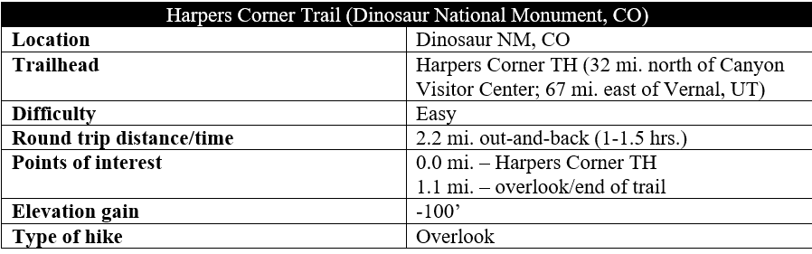
Following a pinyon- and juniper-studded ridgeline out to its terminus, the Harpers Corner Trail features stunning panoramic vistas high above canyon country in Colorado/Utah’s Dinosaur National Monument. The landscape below, cut and eroded by the Green and Yampa Rivers, spans millions of years of geologic time, from the Lodore Formation (rock deposited nearly 500 million years ago) to the Weber sandstone (circa 300 mya). Better yet, a useful trail guide (available for $1 at the trailhead or the Canyon Visitor Center) and 16 wayside markers along the route provide visitors with a tour of the geological, ecological, and human history of the area, making this one of the most informative hikes in the park. This 2.2-mile round-trip journey is a nice capstone after the long drive on the winding Harpers Corner Road and a must-see on the Colorado side of the monument.
The hike
The 31-mile Harpers Corner Scenic Drive—which rises sharply from the small border town of Dinosaur, Colorado—culminates at its namesake, a lofty finger of land situated more than 2,000 feet above the Green River below. Upon arriving at the parking area at Harpers Corner after the long and curvy drive, visitors will likely be ready to get out and stretch their legs—making the short and easy Harpers Corner Trail (2.2 miles out-and-back) an attractive and worthy option.
Views down to the network of canyons of Dinosaur are partly obscured at the start of the hike, but vistas improve as hikers make their way down the dusty trail. Notice the ubiquitous juniper trees as the initial route descends a set of switchbacks, with the similarly-hearty pinyon pines eventually working their way into the surroundings.

Edge northward on the Harpers Corner Trail, passing wayside markers #1 and #2, then proceed uphill at a mild clip for a short period. The first open views greet visitors at around marker #4 (about 1/3 mile), with a look down to Yampa Bench, Pool Creek, and a lonely homestead known as Chew Ranch—the Chew family settled here around the start of the 20th century, benefiting from the perennial, spring-fed stream that eventually feeds into the Green River.

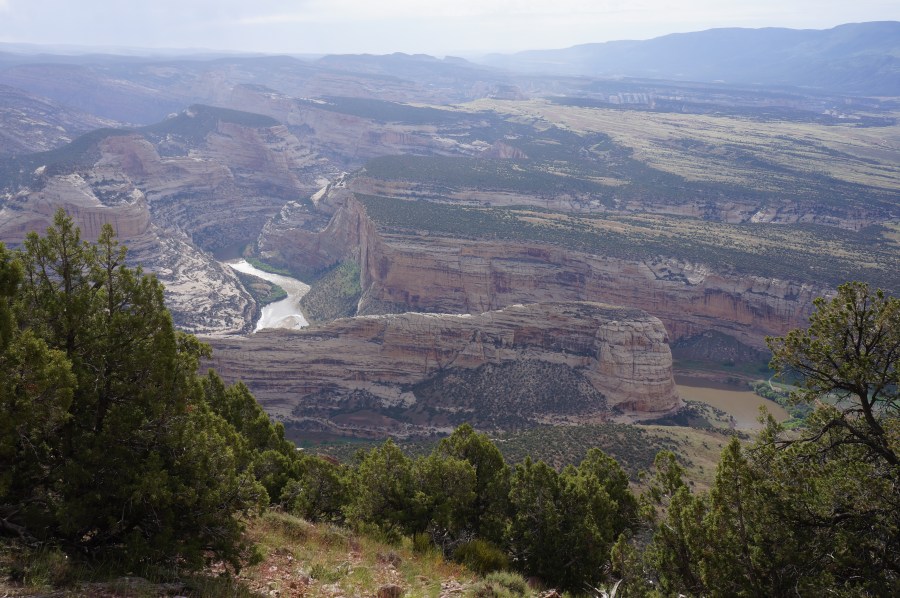
Just beyond this point, hikers get their first views down to Echo Park—a riverside paradise at the terminus of a scenic, unpaved drive—and Steamboat Rock, a hefty chunk of Weber sandstone towering over a hairpin bend in the Green River. One can make out the contours of the campground and day use area, but the confluence with the Yampa River, situated just upstream, remains blocked from view. The views of Echo Park are even better at marker #5 (with the corresponding description in the trail guide briefly recounting the history of the area).

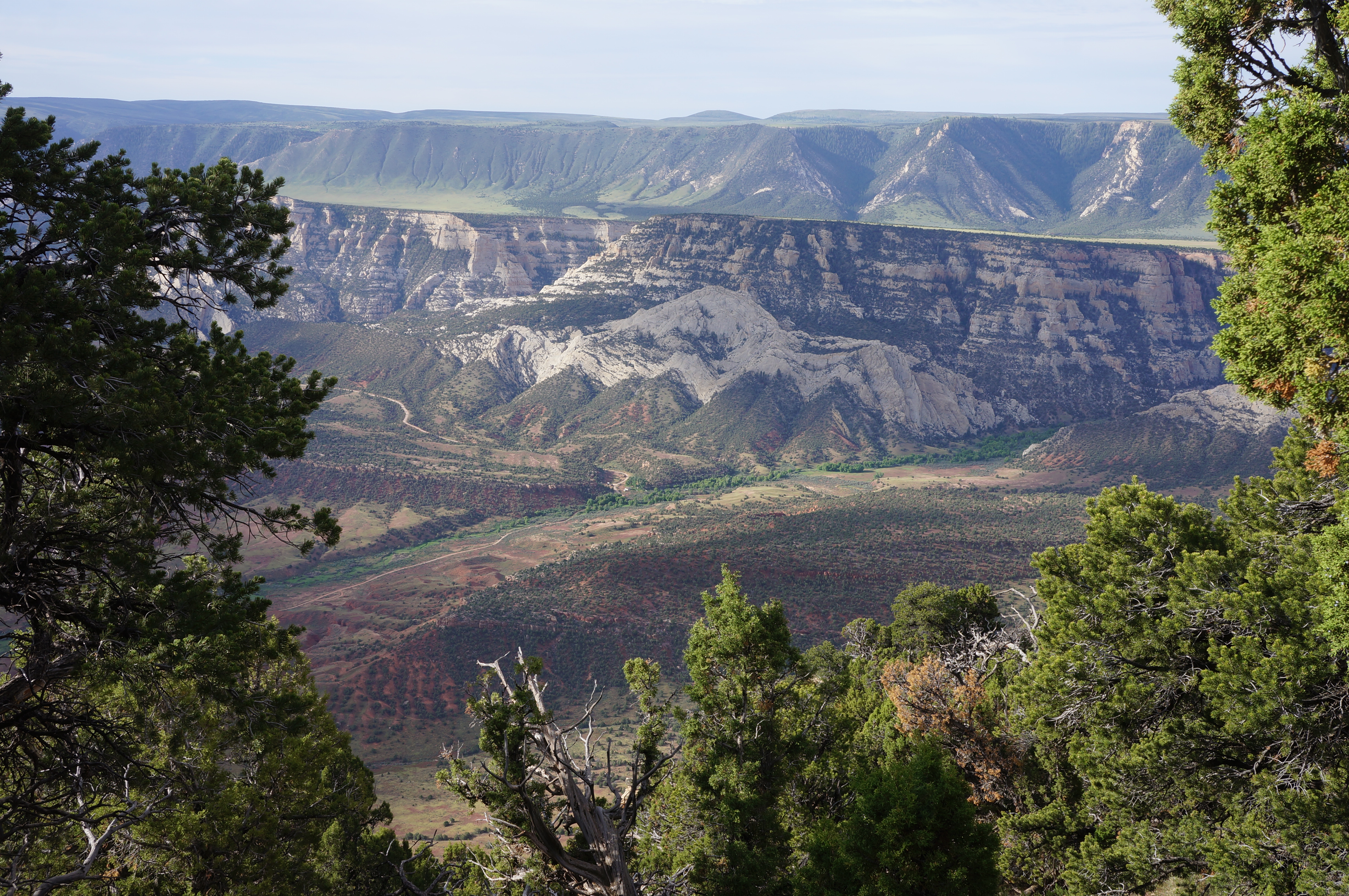
At around ½ mile, the ridge suddenly narrows considerably, with hikers now less than 10 yards from drop-offs on both sides. Here the trail also splits temporarily, with a sign indicating that hikers should proceed up the left fork. At marker #6, there are fantastic views off to the west, down Whirlpool Canyon. Here one can see some of the oldest rock layers in the park—the Lodore Formation, Madison Limestone, and Doughnut Shale—and sneak a peek (on a clear day) of the distant, often snow-capped, peaks of the Uinta Mountains.

Soon the trail rejoins with the other fork and continues uphill between markers #8 and #9. After skirting a clutch of reddish quartzite, the path briefly descends along the shady, west-facing slope. It is a short walk from here to another open and narrow area, a windswept bench with views in both directions. The final stretch—a modest and rocky uphill—awaits, but definitely stop briefly at marker #14, where you can spot small shell fossils in the rocks at your feet.
At last, a little over a mile from the start, the trail abruptly ends at a fenced overlook, with a 270-degree panorama. Look down to the west for an expansive view of Whirlpool Canyon, with Hardscrabble Mountain, Wild Mountain, and Jones Hole Creek coming in from the north. The deep-cut canyons of the younger Weber sandstone dominate the landscape to the east, with the Yampa River now visible beyond Steamboat Rock. At the edge of the cream-colored Weber sandstone, the land abruptly rises in a series of near-vertical streaks: this part of the Mitten Park Fault, an incision in the earth that forced the striated mix of sandstone, limestone, and shale skyward, producing one of the area’s most peculiar geological formations.

On a weekday morning or late evening, hikers may have this viewpoint all to themselves—but otherwise expect a decent amount of foot traffic, with others gawking at the stunning scenery and spectacular landscape. Even with the crowds, this easy walk is a likely standout of any trip to Dinosaur National Monument. Return the way you came (this time staying left again at the brief trail break) to reach the Harpers Corner parking area. Allot around 1-2 hours for the round-trip walk.

Pingback: Top 10 Hikes in 2022 | Live and Let Hike