Oak Creek Canyon (Capitol Reef National Park, UT)

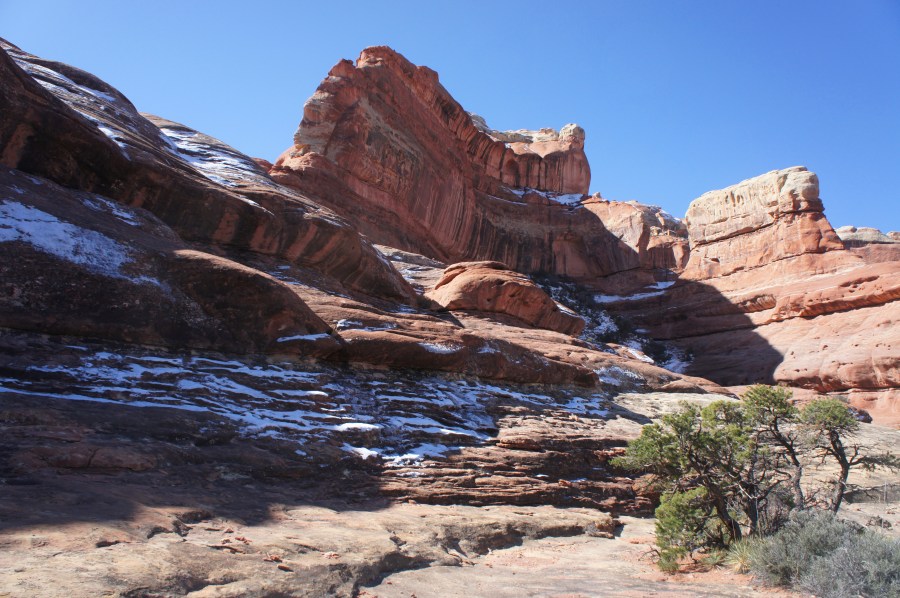
The Waterpocket Fold, a massive wrinkle in the Earth visible in its entirety only from space, stretches north-south for nearly 100 miles through Utah’s Capitol Reef National Park. Despite its considerable length, however, this colorful sea of Jurassic and Triassic era rock is only sliced through in a handful of places. Fewer still, the number …

Continue reading Oak Creek Canyon (Capitol Reef National Park, UT)

Devil’s Garden (Grand Staircase-Escalante National Monument, UT)

For the geologically-minded, the Hole-in-the-Rock Road in Utah’s vast Grand Staircase-Escalante National Monument provides access to extraordinary cuts and sluices in the Navajo sandstone (e.g., Peekaboo & Spooky slot canyons, Coyote Gulch), dating to the early Jurassic Period. These canyons—tributaries of the mighty Escalante River—are situated principally to the east of the dusty, 62-mile access …

Continue reading Devil’s Garden (Grand Staircase-Escalante National Monument, UT)

Brimstone Gulch (Grand Staircase-Escalante National Monument, UT)

(Note: This is the third post in a series of three, highlighting four neighboring slot canyons—all within walking distance of the Dry Fork Trailhead in Utah’s Grand Staircase-Escalante National Monument. The other two posts feature Peekaboo & Spooky slot canyons and the Dry Fork Narrows.) Each year, thousands of adventurers flock to beautiful Peekaboo and …

Continue reading Brimstone Gulch (Grand Staircase-Escalante National Monument, UT)

Dry Fork Narrows (Grand Staircase-Escalante National Monument, UT)

Though just a short walk from Peekaboo, Spooky, and Brimstone Gulch in Utah’s Grand-Staircase Escalante National Monument, the Dry Fork Narrows are often overlooked. Situated at the base of the steep descent from the Dry Fork Trailhead, however, this ½-mile slot canyon is both easily accessible and easily navigable. Unlike its nearby cousins, the narrows …

Continue reading Dry Fork Narrows (Grand Staircase-Escalante National Monument, UT)

Peekaboo Gulch and Spooky Gulch Loop (Grand Staircase-Escalante National Monument, UT)

(Note: This is the first post in a series of three, highlighting four neighboring slot canyons—all within walking distance of the Dry Fork Trailhead in Utah’s Grand Staircase-Escalante National Monument. The other two posts feature nearby Brimstone Gulch and the Dry Fork Narrows.) In the American Southwest, slot canyons are, simply put, an addiction. So …

Continue reading Peekaboo Gulch and Spooky Gulch Loop (Grand Staircase-Escalante National Monument, UT)

Utah Highway 211 to Canyonlands National Park’s Needles District

Canyonlands National Park’s Needles District comprises more than a hundred square miles of spindly spires, dizzying canyons, and colossal views. It also boasts some of Utah’s best hiking and backpacking opportunities, including the Chesler Park Trail, the Big Spring – Squaw Canyon Loop, and the Confluence Overlook Trail. Yet visitors making the 1 ½-hour drive …

Continue reading Utah Highway 211 to Canyonlands National Park’s Needles District

The Castle Trail (Capitol Reef National Park, UT)

Visible from just outside the Visitor Center, the cragged hunk of ochre-colored Wingate sandstone known as “the Castle” is one of Capitol Reef National Park’s iconic landmarks. The monument’s blocky façade—the only surface seen by the vast majority of visitors—disguises a far more rugged northern face, an eroded cluster of spindly fins and needles. An …

Continue reading The Castle Trail (Capitol Reef National Park, UT)

Halls Creek Narrows via “airport route” (Capitol Reef National Park, UT)

Hundreds of thousands flock to southwestern Utah’s Zion National Park each year to witness the famed Zion Narrows, where the majestic Virgin River has sculpted a 16-mile stretch of cavernous bends and twists seemingly unique in their beauty. Midway across the state, however, Capitol Reef National Park boasts a comparably spectacular alternative in the remote …

Continue reading Halls Creek Narrows via “airport route” (Capitol Reef National Park, UT)

Confluence Overlook Trail (Canyonlands National Park, UT)

Utah’s Canyonlands National Park is sliced into three quadrants by the deep cuts of the Colorado River and the Green River: Island in the Sky, Needles, and The Maze. Yet due to the deep incisions formed by the two rivers, very few roadside overlooks, or even backcountry trails, offer a glimpse of either. An exception …

Continue reading Confluence Overlook Trail (Canyonlands National Park, UT)

Big Spring Canyon – Squaw Canyon Loop Trail (Canyonlands National Park, UT)

One of the principal advantages of hiking in Canyonlands National Park’s Needles District is the abundance of loop hikes. At 7.2 miles, the moderately strenuous Big Spring Canyon to Squaw Canyon loop is one of the shortest. While arguably not the most scintillating hike in the Needles (that distinction belongs to the jaw-dropping Chesler Park …

Continue reading Big Spring Canyon – Squaw Canyon Loop Trail (Canyonlands National Park, UT)