– Civil War Series –
Nearly a year after the onset of the conflict at Fort Sumter in April 1861, the Civil War had seen very few significant military engagements in the Eastern Theater. Following the Battle of Bull Run in July 1861, both sides played defense: strengthening their fortifications, bolstering their ranks, and eyeing the enemy with caution. Yet with the two sides’ capitals—Washington and Richmond—just over 100 miles apart, Virginia was fated to see more bloodshed.
As winter gave way to spring, President Lincoln faced tremendous public pressure to mount an assault on Richmond. In November, he tapped a young major general, George McClellan, to head the Union Army; it took another five months to ready the Army of the Potomac, the largest force ever built on the continent. Despite greatly outnumbering Confederate defenders, the months-long Union offensive—known as the Peninsula Campaign (March-July 1862)—would end in failure, owing in large part to McClellan’s consistent reticence to take battlefield risks.
Today, visitors can retrace the Army of the Potomac’s march up Virginia Peninsula on a multi-day driving tour from Hampton Roads to the outskirts of Richmond. Battlefield hikes abound—at Dam No. 1 and the Williamsburg Line, for example—while museums in Richmond, Hampton, and Newport News offer interpretation of the events of spring and summer 1862, a pivotal period in the Civil War.
Although possible to squeeze into a weekend trip, visitors will get a far richer experience if they allot 4-5 days—two on the Peninsula covering the battles of March-May 1862, with at least another two covering the Richmond area and the Seven Days’ Battles (June 25-July 1, 1862). Live and Let Hike breaks the trip in two along these lines: this post covers the Battle of Hampton Roads and the arrival of McClellan’s forces at Fort Monroe in March 1862 through the Battles of Williamsburg and Eltham’s Landing in early May; a subsequent post will cover the battles closer to Richmond, from Drewry’s Bluff (May 15, 1862) through Malvern Hill (July 1, 1862).
Note: The below driving tour roughly follows the itineraries laid out by Virginia Civil War Trails and Michael Weeks’ Civil War Road Trip: Volume I (2011). In this age of GPS, I have included addresses for each site (rough approximations—for example, the nearest house) in lieu of specific directions. See my post on July 7, 2018 for Part 2 of the journey.
DAY 1: HAMPTON AND NEWPORT NEWS (MARCH-APRIL 1862)
Stop 1: Christopher Newport Park (50 26th St., Newport News, VA)
The tour begins in downtown Newport News with the first of several stops dedicated to the Civil War’s naval history. It was here, at the mouth of the James River, that the most famous naval engagement of the war took place: the Battle of Hampton Roads, also known as the Battle of Ironclads. Today’s Christopher Newport Park, near the southwest tip of Virginia Peninsula, looks out over the site on March 8, 1862 where the CSS Virginia made its famous debut. Here the Virginia, the first Confederate ironclad, quickly dispatched of two Union gunboats anchored in the James River—the USS Cumberland and the USS Congress—while nearly sinking a third, the USS Minnesota. The attack instilled panic across the north: the Confederates had built a weapon capable of threatening Washington and outmatching nearly every ship in the Federal fleet…
Note: Allot 10-20 minutes to explore this site.

Stop 2: Monitor-Merrimac Overlook Park (1548 16th St., Newport News, VA)
…Except for one: the USS Monitor, the Union’s very own ironclad, which was newly commissioned on February 25, 1862. On March 9, as the Virginia set off again from Confederate-held Norfolk to finish the job of sinking Federal gunboats, the Monitor arrived to meet it. The battle that ensued went down in naval lore: iron versus iron, a slug fest that, after hours of fighting, ended in a draw.
You can see the area where the two ironclads fought from Monitor-Merrimac Overlook Park in Newport News, roughly a 10-minute drive east of Christopher Newport Park. Signs offer interpretation of the events of March 9, 1862, while a fishing pier offers an opportunity to walk out over the river.
Note: Allot 10-20 minutes to explore this site.

Stop 3: Fort Monroe National Monument (20 Bernard Rd., Hampton, VA)
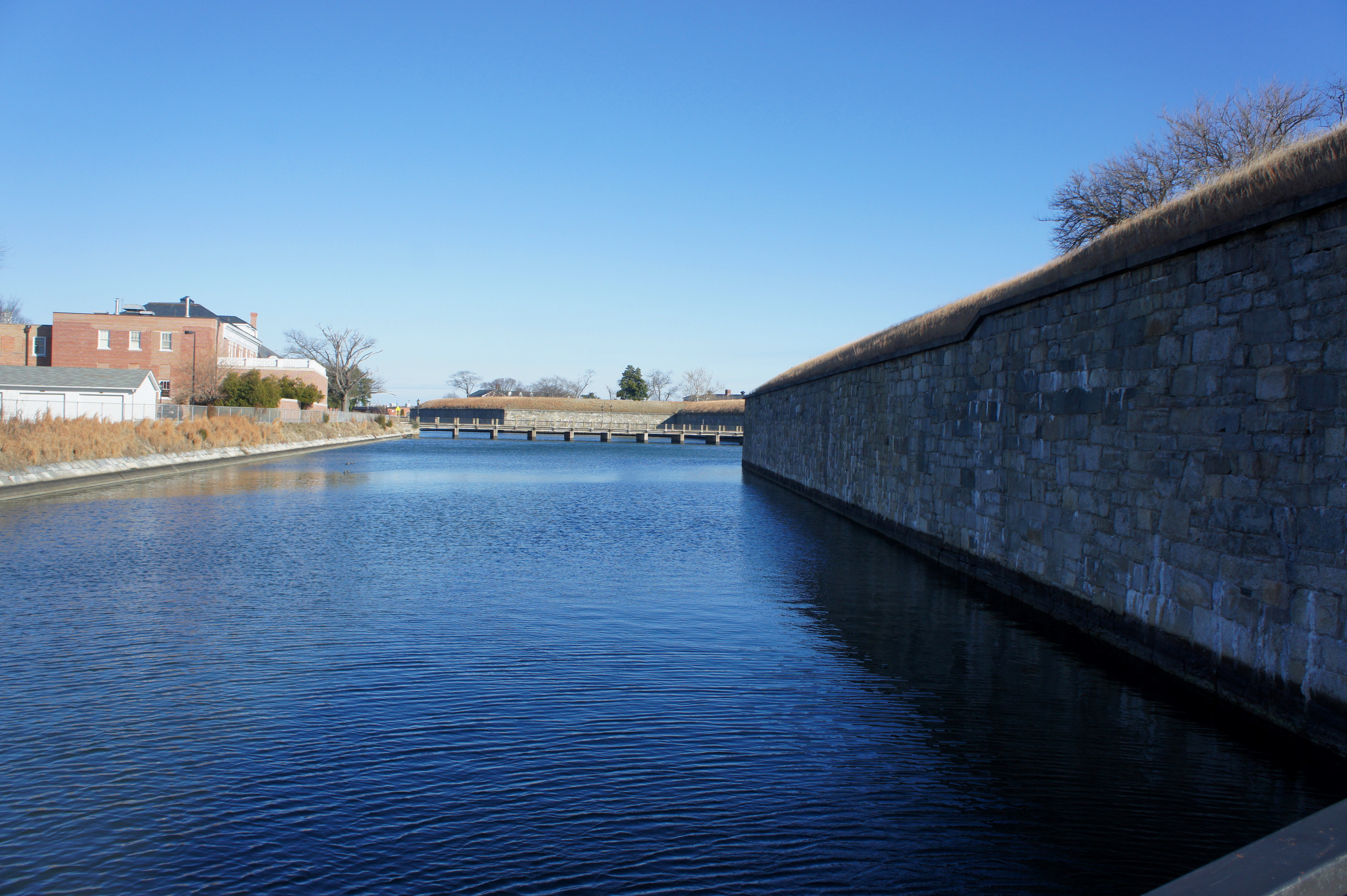
Fort Monroe, situated on the southeast tip of Virginia Peninsula, served as base of operations for Union forces during the Peninsula Campaign. As Virginia seceded in May 1861, Federal forces reinforced the base to ensure the Union kept a foothold on the peninsula; it later served as the staging point for McClellan’s Army of the Potomac as it began its march on Richmond in April 1862. The largest stone fort in the U.S., Fort Monroe boasts high ramparts and an impressive surrounding moat. Visitors can easily spend a couple hours in the Casemate Museum, which covers the area’s storied history, from the colonial period to the Civil War to the World Wars to the present. Decommissioned as an active military base in 2011, Fort Monroe National Monument is now operated by the National Park Service.
Note: Allot 2-3 hours to explore this site. See my post on March 18, 2017 for a full description. After touring Fort Monroe, it will be close to midday, and you’ll be ready for lunch.
Stop 4: Mariners’ Museum and Park (100 Museum Dr., Newport News, VA)
Rounding out the naval sites, a visit to the Mariners’ Museum in Newport News is a must. While no significant battles took place here, the museum’s USS Monitor Center boasts an impressive display on ironclad warfare and the Battle of Hampton Roads. The crown jewel is the Monitor’s actual iron turret, lost at sea for more than a century until it was rediscovered in 1973, then recovered and transferred to Newport News in 2002.
One can easily spend upwards of 2-3 hours in the USS Monitor Center, let alone the rest of the museum, which has various exhibits on maritime history. The grounds of the museum also include a 5-mile loop trail around Lake Maury.
Note: Allot 3-5 hours to explore this site. Be sure to leave by 3 or 4pm, however, to see the other sights of Day 1.


Stop 5: Young’s Mill (335 Old Grist Mill Ln., Newport News, VA)
Young’s Mill is the first stop dedicated to the land war on Virginia Peninsula, an effort that—to seemingly all observers except for McClellan—was well overdue. Throughout the winter, McClellan made little movement toward pressing the attack, purportedly leading Lincoln to quip, “If General McClellan does not intend to use his army, may I borrow it?” Finally, after shelving an earlier plan to land forces at the Rappahannock River farther north, McClellan launched his offensive from Fort Monroe in early April 1862. Despite having more men than any city in Virginia, however, McClellan’s Army of the Potomac moved cautiously. Brig. Gen. Erasmus Keyes’ IV Corps marched up the west flank of the peninsula, encountering its first Confederate resistance here at Young’s Mill on April 4.
Southern troops at Young’s Mill covered the far right of Col. John Magruder’s first line of defense. Tasked with defending the peninsula from Federal forces, Magruder in 1861 set out to construct three defensive lines: the first, weakly manned, served more as a series of surveillance posts, while the second and third—further west—were heavily fortified. As Keyes’ forces approached Young’s Mill, the Confederate contingent here offered a token resistance before quickly falling back to the better-defended second line.
Today, a small white building at Young’s Mill remains, as well as modest Confederate earthworks, the only remaining remnants of Magruder’s first line.
Note: Allot 5-10 minutes to explore this site.

Stop 6: Warwick Court House (886 Tulip Dr., Newport News, VA)
On April 5, the Warwick Court House became the headquarters for Keyes’ IV Corps during the month-long siege of Magruder’s heavily-defended second line. Here the Union made use of relatively new technology: gas-powered balloons, which engineers constructed to surveil Confederate positions. Today, the old court house building is overshadowed by its newer cousin, which also boasts in its front yard a gaudy Confederate monument built in 1909 to commemorate the dead from Warwick County.
Note: Allot 5-10 minutes to explore this site.

Stop 7: Lee’s Mill Historic Park (280-310 Rivers Ridge Circle, Newport News, VA)
Keyes’ march ended abruptly on April 5 here at Lee’s Mill, where Magruder’s Confederates had constructed robust earthworks to thwart the Union advance. Perched at a strategic crossing across the Warwick River, Southern troops greeted Keyes’ IV Corps with a barrage of artillery fire—followed by an infantry counter-attack—that was sufficient to repel the Federal invaders. It would also reinforce McClellan’s excessive caution: it would be another month until “Little Mac” felt confident enough to send his full force across Magruder’s second line.
Today, a short loop trail circuits the earthworks, and Virginia Civil War Trails signs provide a narrative explanation of the fighting.
Note: Allot 20-30 minutes to explore this site. See my post on March 19, 2017 for a full trail description. By now, it will probably be late afternoon on your first day.

Stop 8: Skiffes Creek Redoubt (266 Enterprise Dr., Newport News, VA)
The Skiffes Creek Redoubt is another remnant of the Confederate second line. Expecting a Union attack from the James River, Magruder heavily fortified the line’s right flank, including this redoubt—a small, enclosed defensive fort built from earth, sod, and timber. The river attack never materialized, and the only battles along the second line took place farther south and east at Lee’s Mill, Dam No. 1, and Yorktown. Today the Skiffes Creek Redoubt is situated in a wooded area between industrial parks and can be accessed via a short, wheelchair-accessible boardwalk.
Note: Allot 5 minutes for this site.

Stop 9: Dam No. 1 (Discovery Center, Newport News Park, Newport News, VA)
By mid-April, after Keyes’ retreat at Lee’s Mill, McClellan was convinced that he faced a formidable enemy of at least 100,000 strong. Instead of pressing the attack, he instead settled in for a more passive siege; using dozens of heavy guns, he aimed to gradually blast his way through Magruder’s Warwick-Yorktown Line. He did allow for one attempt at piercing the line, however, dispatching an undermanned force under Brig. Gen. William “Baldy” Smith on April 16 to seize a Confederate position at Dam No. 1. The ill-fated raid would end in the second Union defeat in as many weeks. Now situated in Newport News Park, the site of the Battle of Dam No. 1 can be toured by way of a lengthy bridge across Lee Hall Reservoir, followed by a short hike on the Twin Forts Loop Trail.
Note: Allot 45 minutes-1 hour to explore this site. See my post on March 25, 2017 for a full trail description. By the time you get to Dam No. 1, it will likely be close to sundown; if you lack the time to complete the hike, skip it or come back in the morning.

DAY 2: YORKTOWN AND WILLIAMSBURG (MAY 1862)
Stop 10: Lee Hall Mansion (163 Yorktown Rd., Newport News, VA)
After a busy first day in Hampton and Newport News, Lee Hall is the first stop on the second day of this driving tour. The antebellum mansion situated here served as the temporary headquarters for Magruder and Gen. Joseph E. Johnston during the Peninsula Campaign. After the Battles of Lee’s Mill and Dam No. 1, the relationship between these two Confederate generals would sour: upon his arrival, Johnston—who outranked Magruder—would demote the masterful defender to the status of divisional commander and would later outright release him from his command in late May.
Today, Lee Hall Mansion remains preserved and costs $8.00 to tour. Outside are the remains of a small redoubt, the only surviving earthworks at the site.
Note: Allot 5 minutes for this site (or up to an hour if you do a tour). The mansion does not open until 10am (or 12/1 on Sundays), so it’s best to skip the tour and just move on.
Stop 11: Lebanon Church & Endview (431 Yorktown Rd., Newport News, VA)
Just up Yorktown Road from Lee Hall, as the road edges an open field, pull off to the right, where there are several waysides. Across the street is historic Lebanon Church, situated at a strategic crossroads held by Confederates until May 4, when some of McClellan’s forces established a base here. On the other site of the field, the Endview farmhouse served as a field hospital during the war, first for the Confederates, then for Federal troops.
Note: Allot 5 minutes for this site. It is possible to tour the Endview Plantation, though the site does not open until 10am (12/1 on Sundays).

Stop 12: Yorktown Battlefield (901 Goosely Rd., Yorktown, VA)
During the Battle of Yorktown in 1781, George Washington’s Continental Army employed siege guns to blast away at British defenses. Eighty-one years later, General McClellan would use the same tactics, again at Yorktown, against Magruder’s second line. Vastly overestimating the Confederate force ahead of him, McClellan suspended the Federal march up the Peninsula in early April 1862, instead deciding to roll huge siege guns to Yorktown to prepare for a concentrated artillery barrage. On May 3, however, he lost his opportunity, as Johnston’s troops retreated back toward Richmond.
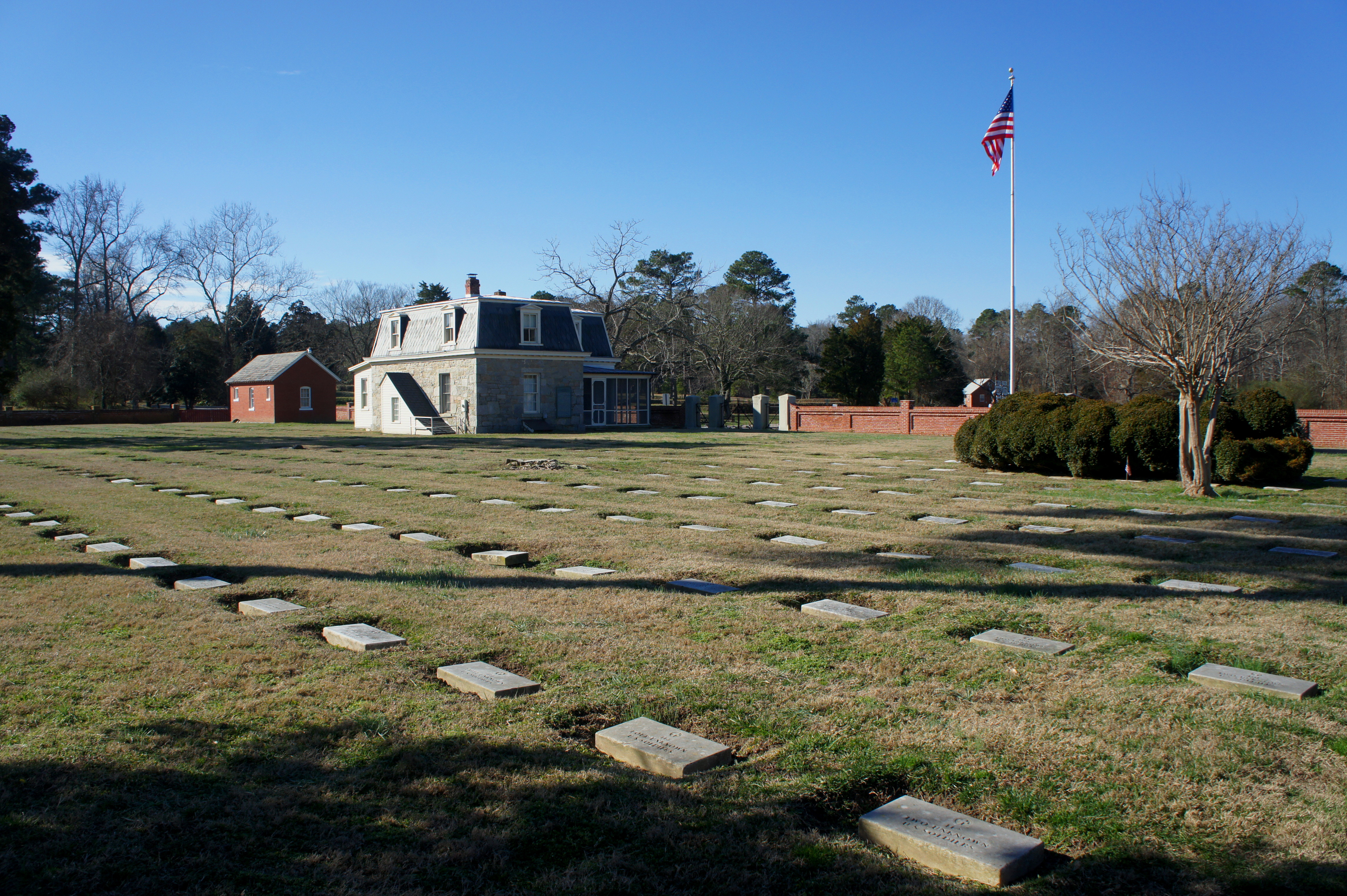
There are a few remnants of the 1862 Siege of Yorktown at today’s Colonial National Historical Park. Though the park’s focus is the Revolutionary War, you can pick up information on the Civil War at the visitor center, including a Civil War auto tour companion guide. A Civil War Trails wayside near the intersection of Goosley Road and George Washington Memorial Parkway overlooks a Civil War trench line, and the Yorktown National Cemetery commemorates the Union dead in the Yorktown area. Though meant to reflect their appearance in 1781, the reconstructed earthworks at Yorktown also saw use in 1862; both the Confederates and Federals reinforced the existing British and American fortifications, while the previous “no-man’s land” between the two sides was scattered with Union rifle pits. The Moore House, site of the British surrender in October 1781, served as a Union signal station during the Civil War.
Note: Allot at least one hour for this site. (If you are pairing this with a tour of the Revolutionary War sites, allot at least 2-3 hours.)

Stop 13: Yorktown Waterfront (586 Water St., Yorktown, VA)
Beyond the battlefield, continue downhill to the banks of the York River in downtown Yorktown, where a single Civil War Trail wayside continues the story where it left off: following the Confederate retreat on May 3, McClellan’s Union forces turned Yorktown into a bustling port to support the Federal advance on Richmond. (Note: Around the same time, Federal forces recaptured Norfolk farther south, forcing the Confederates to scuttle the CSS Virginia and thus removing a key obstacle to bringing Union naval assets to the fight.)
Note: Allot 5 minutes for this site, or 30 minutes to explore Yorktown Beach and Waterfront.

Stop 14: Tyndall’s Point Park (1376 Vernon St., Gloucester Point, VA)
The final stop in the Yorktown area is across the George P. Coleman Memorial Bridge in Gloucester Point. A short walk at Tyndall’s Point Park covers both the Revolutionary and Civil War history of this strategic outpost, and impressive earthworks remain intact. The Confederate artillerymen here at Gloucester Point outlasted the rest of the Southern Army on the Warwick-Yorktown Line; it kept firing as the Federals moved into Yorktown on May 3-4. By the end of May 4, however, the troops garrisoned here were forced to retreat, ceding Gloucester Point to Union forces, who used it as a base for the remainder of the Peninsula Campaign.
Note: Allot 20 minutes for this site, which includes a ¼-mile round trip walk.

Stop 15: Redoubt Park (510 Quarterpath Rd., Williamsburg, VA)
It’s a 25-minute drive from Gloucester Point to the next destination, Redoubt Park, in Williamsburg. Once the bustling capital of colonial Virginia, Williamsburg by the start of the Civil War had fallen into disrepair. Nonetheless, Magruder chose the Williamsburg area to construct his third and final line of defenses on the Peninsula: a series of 14 redoubts aimed at slowing a Federal advance. This line was not as well defended as Magruder’s second, however, and several redoubts remained unfinished on the eve of battle in early May 1862.
Redoubt Park protects the remains of Redoubts 1 and 2, which remain well-preserved but saw no fighting during the war. Waysides along a pair of trails in the park elaborate on the story of Magruder’s third line and the Battle of Williamsburg, the first pitched battle of the Peninsula Campaign.
Note: Allot around an hour to complete both walks—the ¼-mile Redoubt 1 Trail and 1-mile Tuttle Trail—at Redoubt Park. See my posts on April 6, 2017 and April 7, 2017 for full trail descriptions. It should be early afternoon by the time you finish at Redoubt Park.
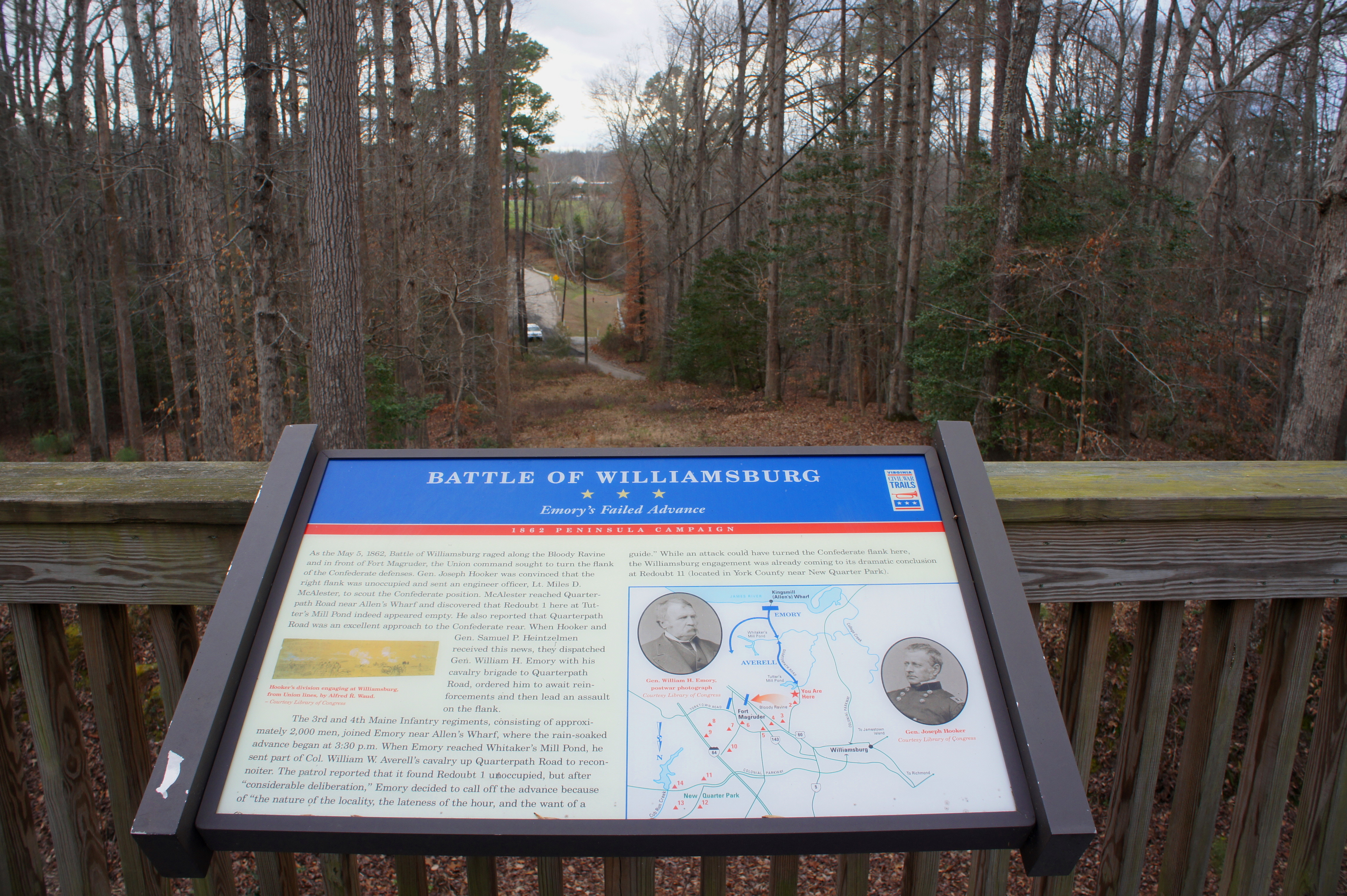


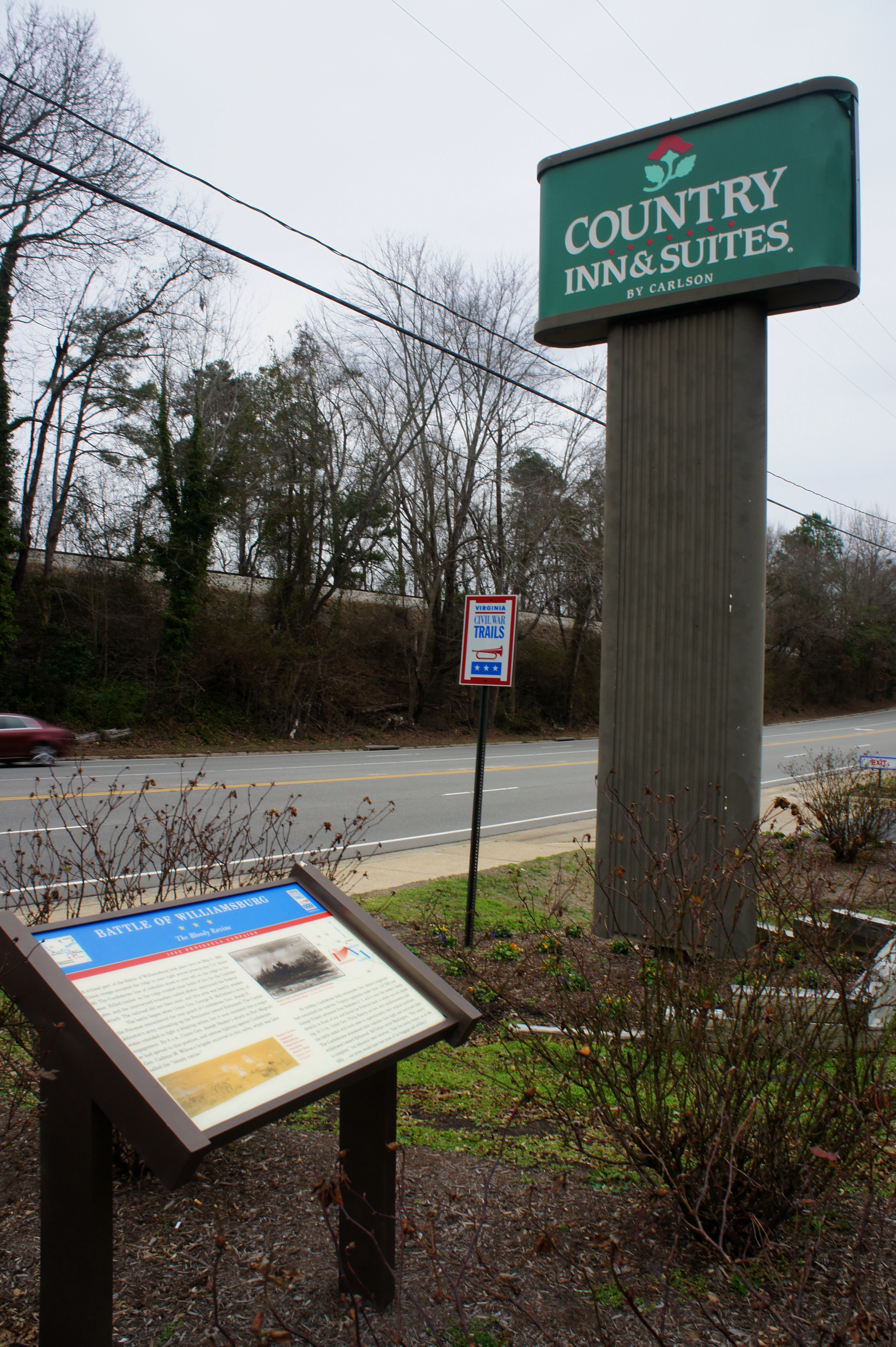
Stop 16: Bloody Ravine (7135 Pocahontas Trail, Williamsburg, VA)
Situated in the parking area at a Country Inn and Suites, the Civil War Trails wayside at the so-called “Bloody Ravine” is perhaps the most awkward stop on the Peninsula Campaign tour. It is, however, one of the more consequential. On May 5, 1862, this woody area saw the most intense fighting of the Battle of Williamsburg. After retreating to Magruder’s third line on May 3, Gen. Johnston’s Confederates clashed with McClellan’s Army of the Potomac two days later at several points along the Williamsburg Line. Here at Bloody Ravine, Confederate Gen. Cadmus Wilcox’s brigade succeeded in repelling a Federal attack by a portion of Union Brig. Gen. Joseph Hooker’s division. Outnumbered, however, Johnston’s Confederates were forced to retreat again on the night of May 5, continuing their withdrawal toward Richmond.
Note: Allot 5 minutes for this site, which is no more than an awkward sign in front of the Country Inn.
Stop 17: Fort Magruder (1035 Penniman Rd., Williamsburg, VA)
Fort Magruder was the centerpiece of Magruder’s Williamsburg Line and came under attack on May 5 by Union Gen. Hooker’s division. While the brunt of the fighting took place further west at Bloody Ravine, the fort was the scene of furious artillery fire throughout the day. Dubbed by one Union commander as “a very ugly place to have an attack,” Fort Magruder looks slightly better today: a grassy patch that retains part of its hilly perimeter, a welcome respite amid a sea of suburban development. A closed fence, however, prevents access to the redoubt interior.
Note: Allot 5 minutes for this site. Park in the church parking lot immediately to the north of the site.

Stop 18: Redoubts 12 & 13 (New Quarter Park, 1000 Lakeshead Dr., Williamsburg, VA)
Northeast of Fort Magruder, Redoubts 12 and 13 covered the far left flank of Magruder’s third line. Neither was occupied by Confederates during the Battle of Williamsburg, but they remain accessible in New Quarter Park, a large tract of woods near the York River. (Note: Redoubts 11 and 14 fall just outside the park and thus are inaccessible.) You can read about Redoubts 11-13 at the Civil War Trails wayside at the park entrance. Reaching Redoubts 12 and 13, however, takes a little more effort: 12 is a short hike from the main parking area at the end of Lakeshead Drive, while reaching 13 requires cutting across the disc golf course at New Quarter Park. (Note: Redoubt 13 is in the woods behind disc gold holes 14 and 15.) Ask at the Park Office for more information.
Note: Allot 30 minutes to reach and explore the two redoubts.


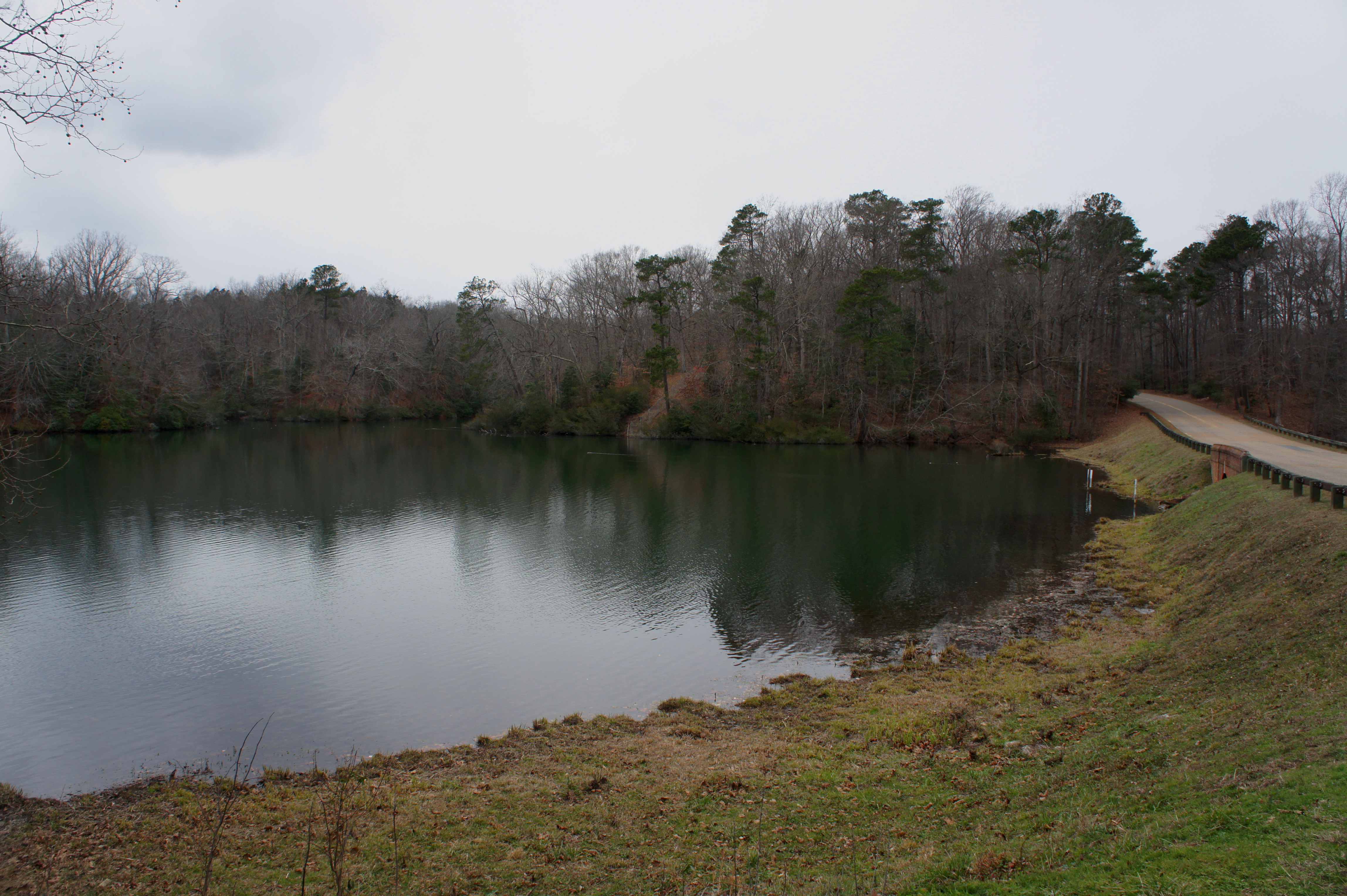
Stop 19: Cub Creek Dam (Colonial Parkway, Williamsburg, VA)
Situated off Colonial Parkway at Cub Creek Dam (around 2 miles east from the turnoff to Lakeshead Drive), a small pullout offers a view of a peaceful reservoir called Jones Millpond. This area was anything but peaceful during the Battle of Williamsburg, however: in the now-wooded area just to the west, forces under Union Brig. Gen. Winfield Scott Hancock seized Redoubt 11 and repulsed a counter-attack by four brigades under Gens. Daniel Harvey Hill and Jubal Early. “Hancock the Superb” would earn praise for the victory and continue his rise to stardom at Gettysburg a year later. (Note: Lt. George Custer, who would make his “Last Stand” in Montana in 1876, took part in Hancock’s attack on Redoubt 11.)
Note: Allot 5 minutes for this site. Having finished all the Battle of Williamsburg sites, you can call it a day from here, or continue on to the Eltham’s Landing area, site of another minor battle on May 7, 1862.
EXTRA CREDIT: ELTHAM’S LANDING AND BEYOND (MAY 1862)
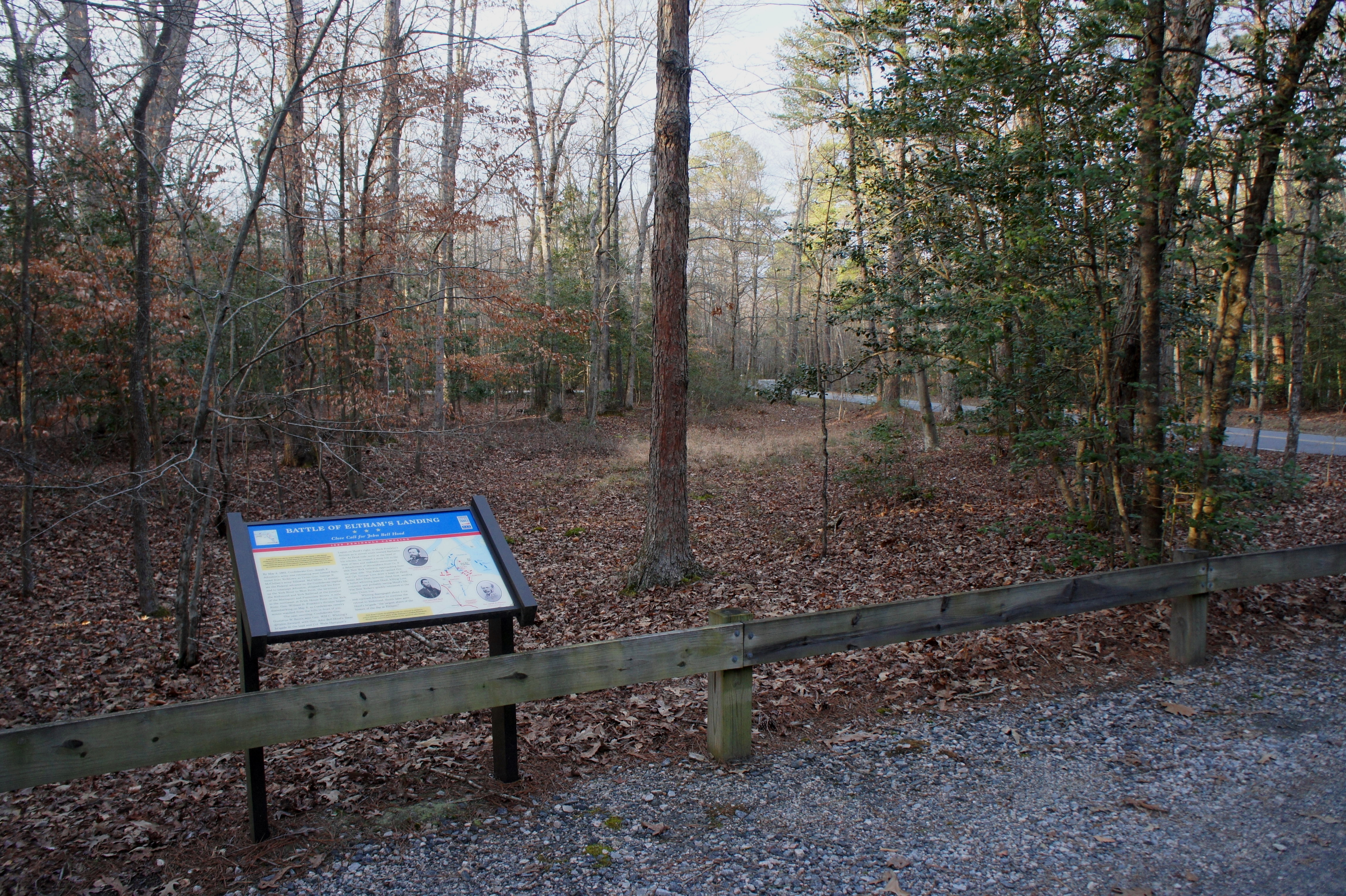
Stop 20: Eltham’s Landing Site 1 (7090 Farmers Dr., Barhamsville, VA)
The first of two sites dedicated to the Battle of Eltham’s Landing (May 7, 1862) is a roughly 30-minute drive northwest of Cub Creek Dam. Look for a small clearing amid the trees on the left, roughly 3.8 miles up Farmers Drive from Barhamsville, Virginia. Here there is a parking area and a single Civil War Trails sign dedicated to this minor engagement.
The battle developed out of an attempt by McClellan to move several divisions by water and stage an amphibious landing to cut off Johnston’s retreat. It was a decent concept but quickly detected by Confederate forces, who marched to meet the Federals as they disembarked near West Point. Around midday on May 7, Confederate Gen. John Bell Hood’s brigade encountered and drove back Union Gen. William B. Franklin’s advancing division before returning to join the rest of Johnston’s army, which continued to withdraw toward Richmond.
Note: Allot 5 minutes for this site.
Stop 21: Eltham’s Landing Site 2 (Farmers Dr. and Plum Point Rd., Plum Point, VA)
The story picks up again less than a mile up Farmers Drive on the right, at the junction with Plum Point Road. It was near here that Franklin’s division landed on May 6 before marching south the next day and encountering Hood’s brigade. While only a minor engagement, Confederate success at the Battle of Eltham’s Landing prevented McClellan’s army from cutting off Johnston’s army from Richmond.
Note: Allot 5 minutes for this site.

Stop 22: New Kent Court House (8038 Courthouse Cir., New Kent, VA)
The final stop on this tour is New Kent, Virginia, site of Martha Washington’s birthplace and a waypoint on Johnston’s retreat up the Peninsula toward Richmond. There is little Civil War interpretation here, aside from a historical marker constructed in 1942 in front of the old New Kent Court House. For those continuing on to Part 2 of the Peninsula Campaign Tour in Richmond, New Kent is a waypoint along the way; for those heading back to the DC or Baltimore area (as I was), it is a spot to catch on the way home from Virginia Peninsula.
Note: Allot 5 minutes for this site. The final stop, New Kent is a half-hour drive from Richmond and a 2 ½-hour drive from Washington, DC.

Although McClellan suffered numerous setbacks in his march up the peninsula, the Army of the Potomac remained largely intact following the Battles of Williamsburg and Eltham’s Landing in early May 1862. It would be another month and a half until McClellan would finally forgo his attempt to seize Richmond. Nonetheless, McClellan’s consistent inability to seize the initiative on the Peninsula and to make a significant dent in Johnston’s Army of Northern Virginia ultimately contributed to the Union’s failure as it approached Richmond in mid-May. Again reflecting an overabundance of caution, McClellan slowed his advance following the Battle of Williamsburg, choosing to regroup and gear up for another siege rather than press the attack. Despite superior numbers, McClellan ceded the advantage to the Confederates, setting the stage for a series of Southern counter-offensives in late May and June that will be covered in the Peninsula Campaign Tour – Part 2…

Pingback: Yorktown Battlefield Auto Tour (Colonial National Historical Park, VA) | Live and Let Hike
Pingback: Road to First Manassas Driving Tour | Live and Let Hike
Pingback: Malvern Hill Trail (Richmond National Battlefield Park, VA) | Live and Let Hike
Pingback: Peninsula Campaign Driving Tour – Part 2 | Live and Let Hike
Pingback: Civil War Driving Tours: Lesser-Known Virginia Trips – Civil War Vacations!