
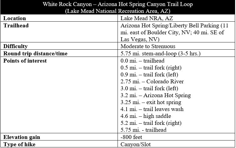
Nestled in the depths of a slot canyon downriver from Lake Mead and the Hoover Dam, Arizona Hot Spring boasts sizzling temperatures of 85-120 degrees year-round. On weekends in winter and spring, residents of the Las Vegas area flock in droves to the spot, with their bathing suits and Tevas in hand, in order to soak in the spring’s three small but pleasant pools. Yet the hike to the spring is arguably even better than the destination, gradually descending impressive White Rock Canyon to the banks of the Colorado River before winding around to the hot springs and ascending Hot Spring Canyon back to the start for a roughly 5.75-mile stem-and-loop hike. (Note: Do not attempt this hike in summer, when temperatures in the Mojave Desert easily top 100 degrees. After all, would want to soak in a hot spring under those conditions?)

The hike
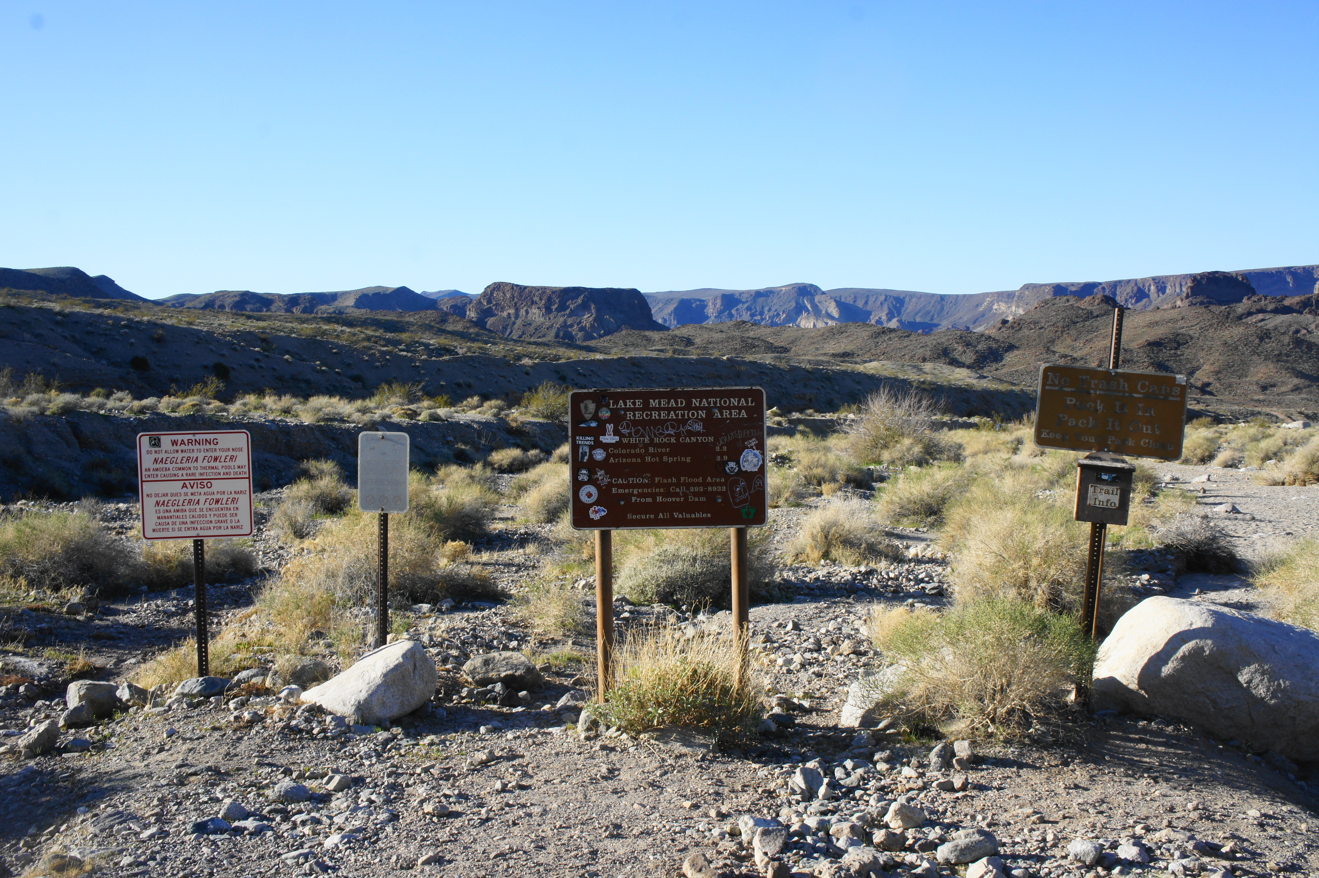
While the bulk of the attractions in Lake Mead National Recreation Area lie on the Nevada side, a short drive from Las Vegas, the White Rock Canyon-Arizona Hot Spring hike is situated just across the border in neighboring Arizona (hence the name of the hot spring). The trailhead can be somewhat tricky to spot: heading southeast on Highway 93 from Boulder City, Nevada, cross the Colorado River into Arizona, then continue for 3.5 miles to a left-hand pull-off that leads to a modest parking lot in the desert scrub. (Note: Being near a major road and metropolis, there tends to be decent cell and data service here, though not in the canyons.) It is wise to arrive as early as possible in the morning for several reasons: hikers can avoid the heat, burgeoning crowds, and parking shortages that worsen as the day progresses.
Trailhead to Colorado River via White Rock Canyon Trail (2.75 miles)
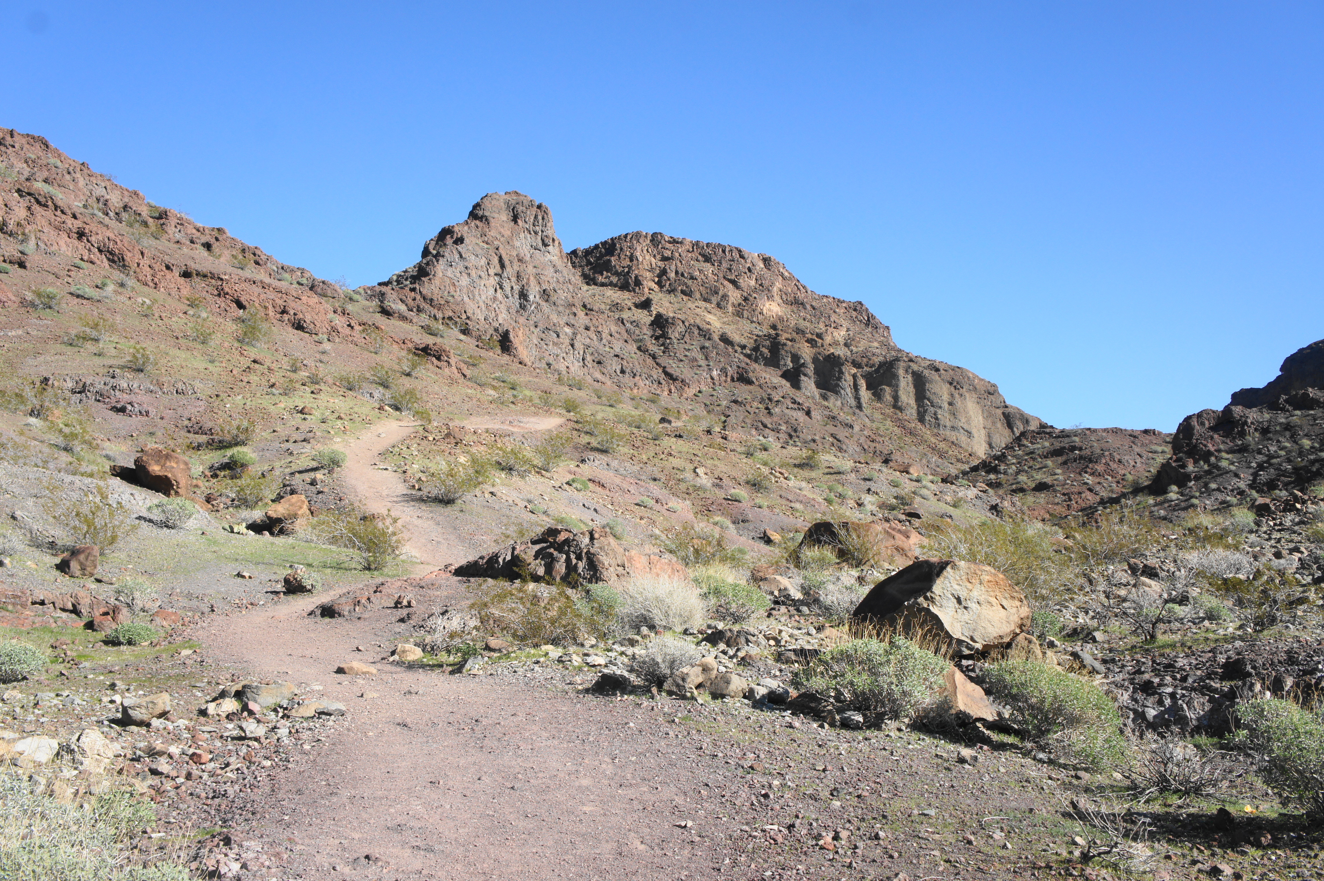
A cluster of hikes are reached from this well-trafficked trailhead—including the Hot Spring Canyon Trail, White Rock Canyon Trail, and Liberty Bell Arch Trail—although all three begin with the same half-mile stretch of dusty wash. After reading and studying the maps and other information at the trailhead kiosk, head down the wide gravel track, which cuts through full sun before proceeding through an underpass of Highway 93. Just beyond, hikers are greeted with a fleet of entry signs, including a warning about a peculiar but deadly form of amoeba—naegleria fowleri—present in the hot springs. (Note: When you’re at the hot spring, be sure to avoid dipping your head under water, as the killer amoeba tends to enter the body through the nose.)
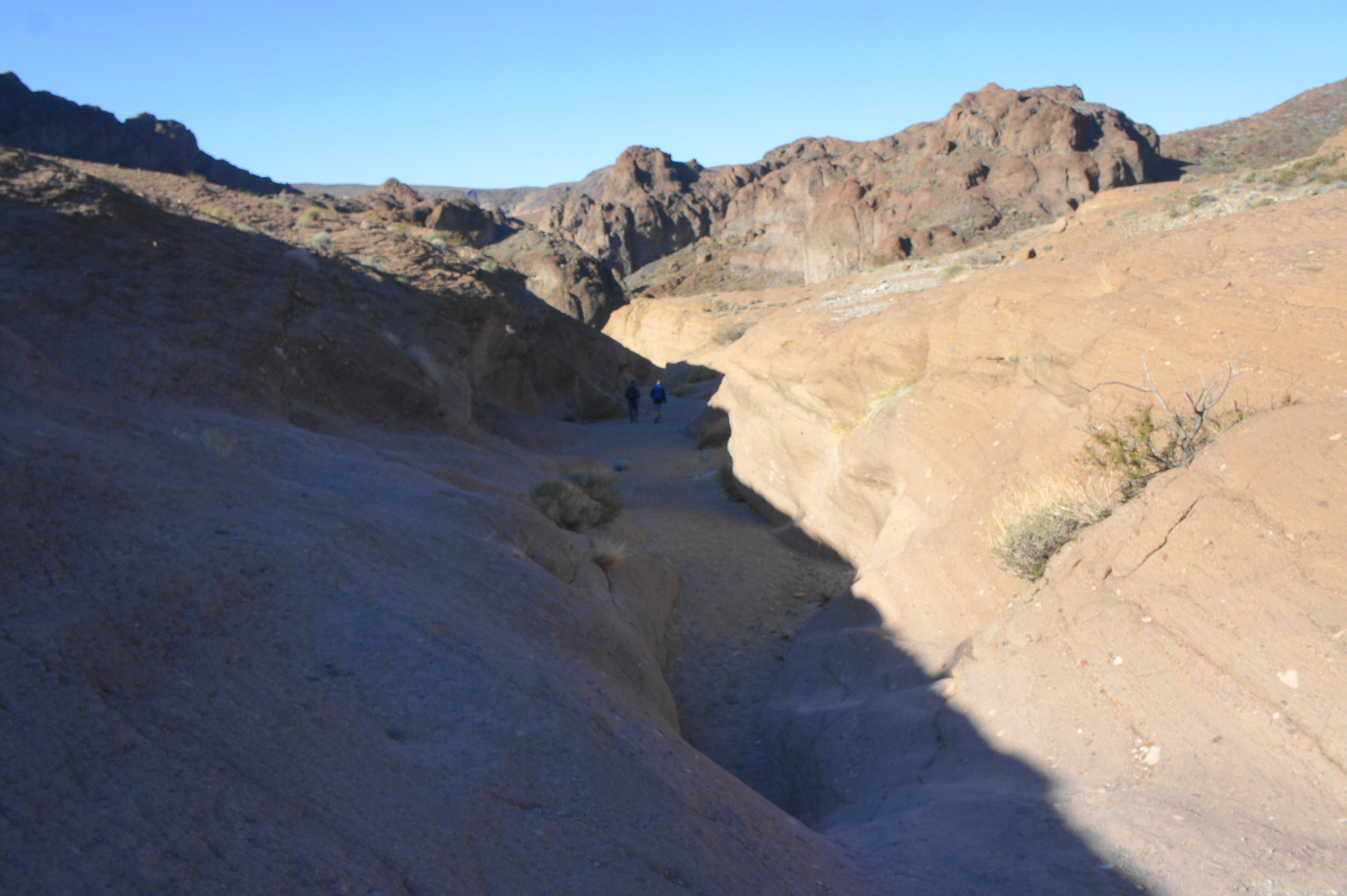
Beyond the signs, the route follows a dusty and largely uninteresting wash for a quarter-mile, although the view of rolling hillsides and towering escarpments teases the maze of canyons and palette of colors ahead. The Lake Mead area is situated at the eastern edge of the Mojave Desert, where the Colorado River has carved deep gorges into the rock, the oldest of which dates to around 1.7 billion years old. While Lake Mead, of course, is a manmade construction, the Colorado River south of the reservoir flows semi-naturally through Black Canyon for several miles before again entering another unnatural feature—Lake Mohave—downstream.
For now, the wash remains relatively open, dotted with only small shrubs, such as burrobush, sage, and Mormon tea. The generally taller creosote bush, a staple of the Mojave Desert, is also ubiquitous in this region. As the wash narrows, the vegetation becomes sparser, replaced by mud banks that grow higher and higher.
At ½ mile, hikers are faced with the first true junction of the hike—an unsigned but well-defined path to left leads up toward Hot Spring Canyon, the shortest and most frequented approach to Arizona Hot Spring. Instead of an out-and-back to the hot spring, however, consider staying right on the White Rock Canyon Trail, which loops around to the hot spring from the north, forming a nice, 4.75-mile circuit. Just beyond, about 100 yards further, a second spur heads left—this too leads to Hot Spring Canyon—but hikers taking the White Rock Canyon route should stay right again.
Just beyond this junction, the wash begins to narrow, hemmed in by ruddy stone walls that grow gradually taller. A two-foot drop in the canyon at about 8/10 mile is easily bypassed on the left, and the canyon continues largely uninterrupted by obstacles for the next two miles.
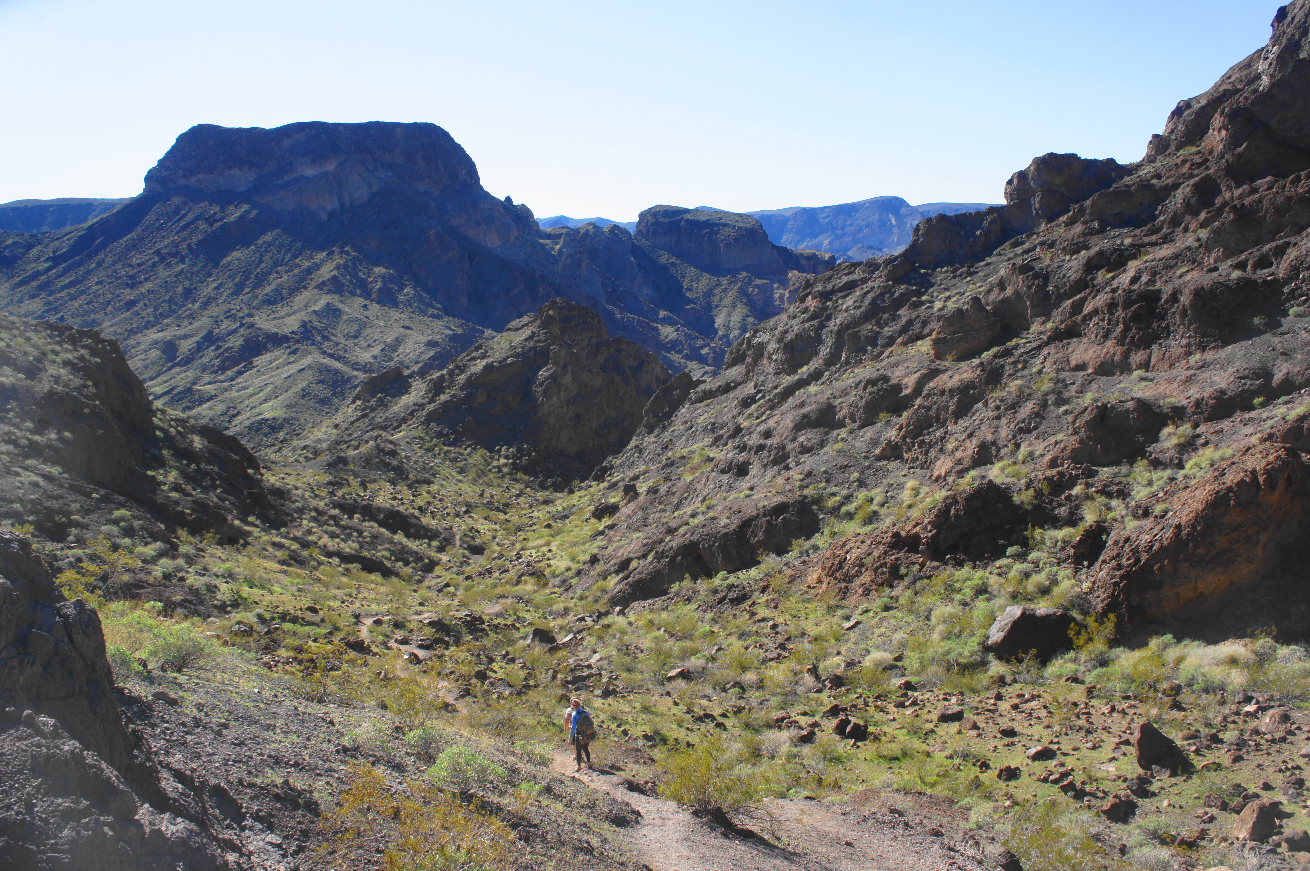
After the brief narrowing, the canyon opens up to small alluvial fan at 9/10 mile, and a signed junction directs hikers heading for Liberty Bell Arch to the right. (Note: While the arch is a worthy destination, it adds an additional 3-mile out-and-back to the hike and thus is excluded from this description. Best saved for another day.) Continue following the wash as it cuts deeper into the rugged mountains, forming high canyon walls and winding passages that are occasionally clogged with fallen granitic boulders. (Note: Although not quite white, these volcanic chunks are presumably what gives the canyon its name.)
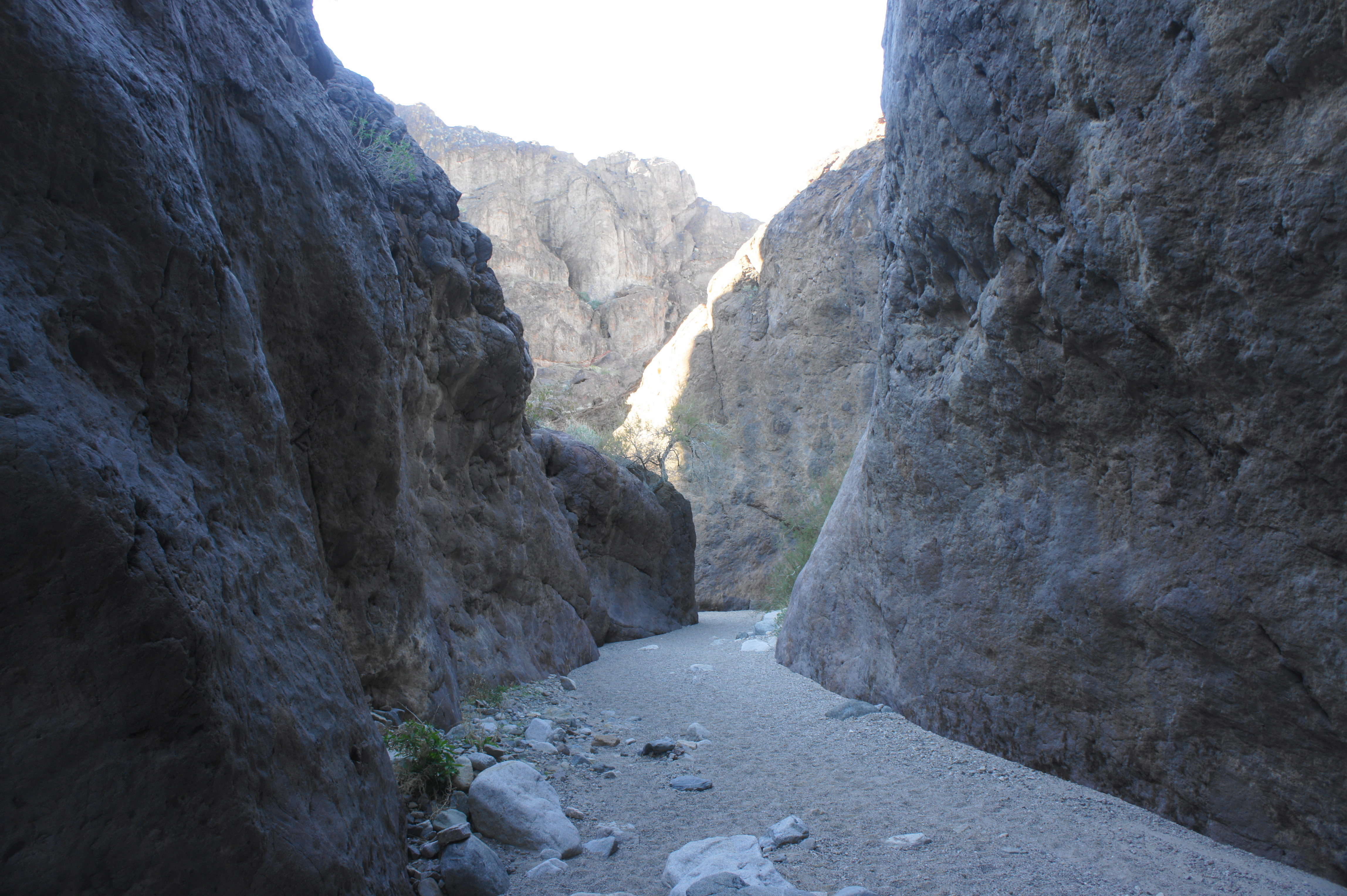
After an initial narrows section at the 1-mile mark, the canyon briefly opens up but then thins again. In the morning, as the sun illuminates the upper reaches of the canyon walls, the base of the canyon remains dark and cool, creating a contrast of colors that ranges from blue, grey, and purple in the depths to orange and red high above.


While narrows are frequent in White Rock Canyon, the canyon never quite thins to a “slot,” and obstacles are rare and easily circumvented. At 1.25 miles, the wash skirts a massive boulder then curves around a set of hairpin bends where the walls narrow almost—but not quite—to a point where one can touch both sides at once.

At 1.5 miles, there is another opening in the canyon, but the narrows quickly return, rounding another set of picturesque bends. The canyon truly widens at about 1.8 miles, revealing high, neatly layered cliffs on both sides, and some vegetation returns to the canyon bottom. Minutes later, the route drops into another set of narrows; at 2.25 miles, the wash passes a heart-shaped incision on the left that looks almost like a dark cave.


Beyond, as the canyon artery compresses and loosens, taller trees appear, including beautiful catclaw acacia (curiously nicknamed “wait-a-minute bush”). At one relatively open area, the slope on the right is littered with fallen rocks and accumulating sediments, and a small arch appears in the heights ahead. The section ahead features arguably the prettiest narrows yet, wrapping around a series of bends, each more enticing than the last.


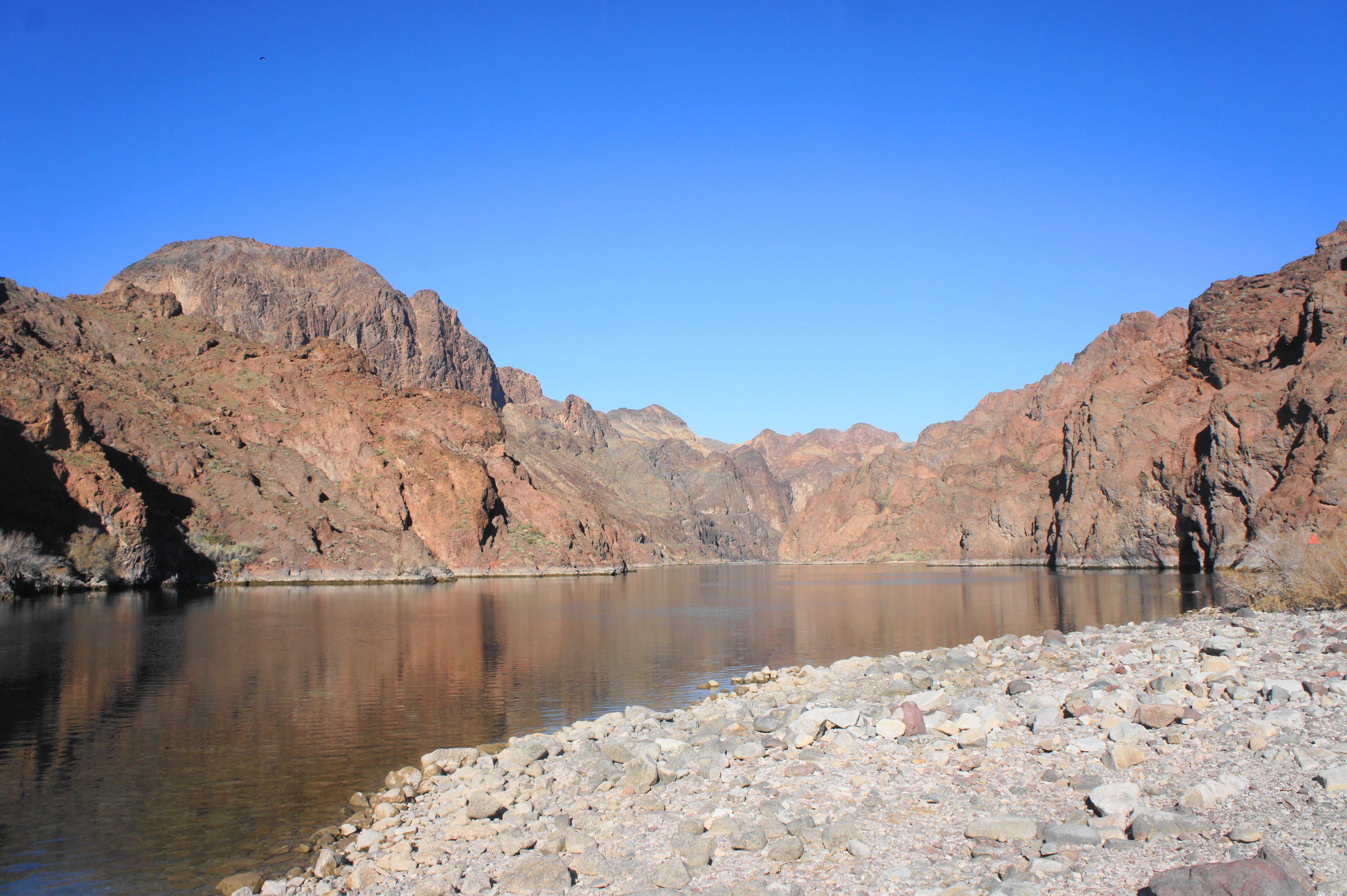
Then comes the jarring finale: an abrupt opening, this time for good, as the canyon walls recede and the wash fans out into a relatively lush delta. The (usually dry) arroyo feeds into the mighty Colorado River, which at this point is relatively calm and soothing, inviting visitors to dip their toes in the shallow waters. Across the Colorado is the state of Nevada, with the Hoover Dam upstream to the north and, eventually, Willow Beach and Lake Mohave to the south. By now the late morning sun has illuminated Black Canyon and the surrounding mountains, bringing out the deep reds and orange hues that are so typical of the American Southwest.
White Rock Canyon to Arizona Hot Spring (0.5 miles)
White Rock Canyon is exciting enough on its own, yet the hike is only halfway done, with the primary destination—Arizona Hot Spring—beckoning. After enjoying the Colorado River views, pick up the trail continuation as it hugs the canyon walls, heading south. (Note: Reportedly there is a sign—Sign #7—that points in the right direction, but I did not see it on my hike in January 2020.) The subsequent section is one of the hike’s toughest—involving some rocky ups and downs and decent exposure—but should be easily passable by most hikers.

After picking up the single-track trail, look for Sign #8, which reveals a narrow passage leading up to a stony notch. A rocky outcrop on the right offers excellent views of the Colorado from about 15 to 20 feet up. From here the trail drops down through a thicket of salt cedars—benefiting from the riparian landscape—followed by a climb to Sign #9. Here there is another rocky knob with nice vistas, but the onward track climbs up through a thin crack that looks more intimidating from afar: with good footholds and a mild incline, the actual climb is relatively straightforward.


Atop another ridge, hikers reach Sign #12 and get their first views down into Hot Spring Canyon, which appears just as enticing as White Rock Canyon—in fact, it is significantly narrower, approaching a true “slot” in this section. From atop the ridge, descend a steep-sloping crack (requiring careful footing), then bend left as the trail drops to the canyon floor. Head left at the canyon floor, continuing upstream toward the hot springs.


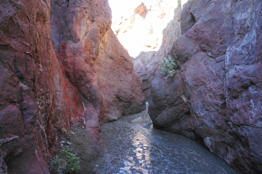
The most obvious difference from White Rock is the presence of water in Hot Spring Canyon, which trickles slowly through the narrow passage, a sign that the hot springs pools are near. Consider changing into water shoes or hiking sandals here, as the subsequent section is more pleasant if you are willing to get your feet wet. There are a few obstacles in this stretch, including a double cascade that requires a straightforward bypass on the right, followed by a narrow slot that is best tackled by mild stemming as the canyon floor is wet and slippery. (Note: This area becomes a traffic jam on crowded days; have patience and take it one person at a time.)


Finally, about 250 yards up the canyon and 3.2 miles from the trailhead, hikers reach Arizona Hot Spring. The springs are hemmed in by sandbags and situated atop a final obstacle: a pour-off that produces a 15-foot waterfall. Otherwise impassable, the pour-off is conquered by climbing a sturdy metal ladder, courtesy of the Park Service.

Just beyond is a sandy landing where visitors take off their socks and shoes for the passage ahead: a series of (usually three) hot springs pools, each one warmer than the last. None are likely to be more than 2- to 3-feet deep, but wading is required. For those seeking a desert cleanse, sit down and enjoy for awhile (but of course, don’t swim or put your nose below water—per above).
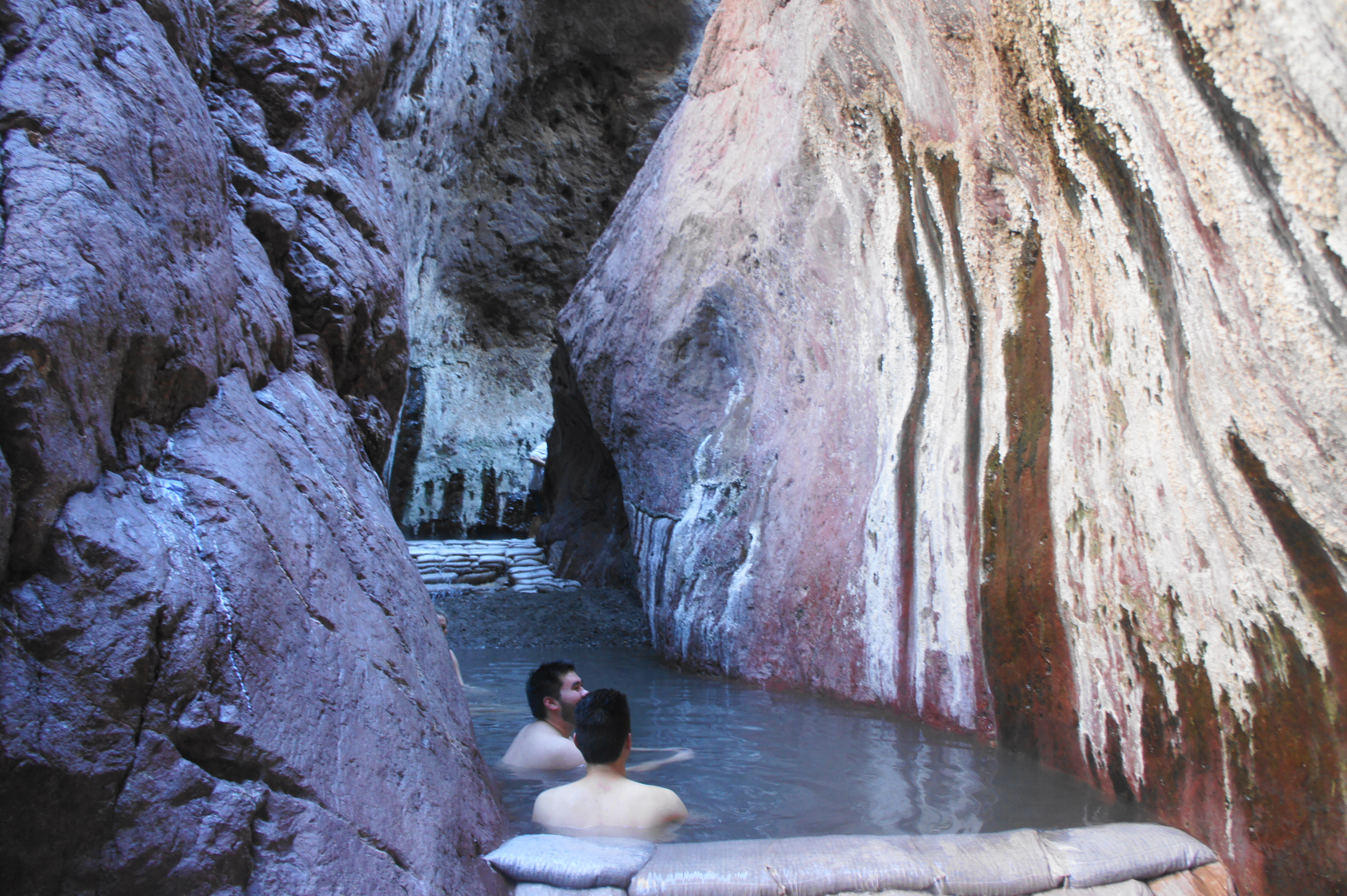
While the springs are the main draw, the canyon itself is impressive on its own—narrowing to about 6 to 8 feet, with sides lined with lichen and desert varnish. The speckled walls tower more than 50 to 75 feet above, offering shade in an otherwise sun-soaked region.

After wading through the first pool, there is a brief break before the second, hotter springs. The third (which was conspicuously missing as of January 2020) is the warmest, and ends with a somewhat tricky scramble up a jagged slope at the base of a boulder jam. This is the springs exit, with the return route via Hot Spring Canyon beyond.


Arizona Hot Spring to Trailhead via Hot Spring Canyon (1.5 miles)
Continuing beyond the hot springs, the return route to the trailhead is shorter than the approach, although there is considerable elevation gain near the end. Beyond the slot section, Hot Spring Canyon opens up, revealing high buttes and plateaus ahead. While not quite as scintillating as White Rock Canyon, the return route does dip in and out of low, colorful narrows. A thin section at 3.5 miles ends at a 3-foot dryfall that requires a little maneuvering.
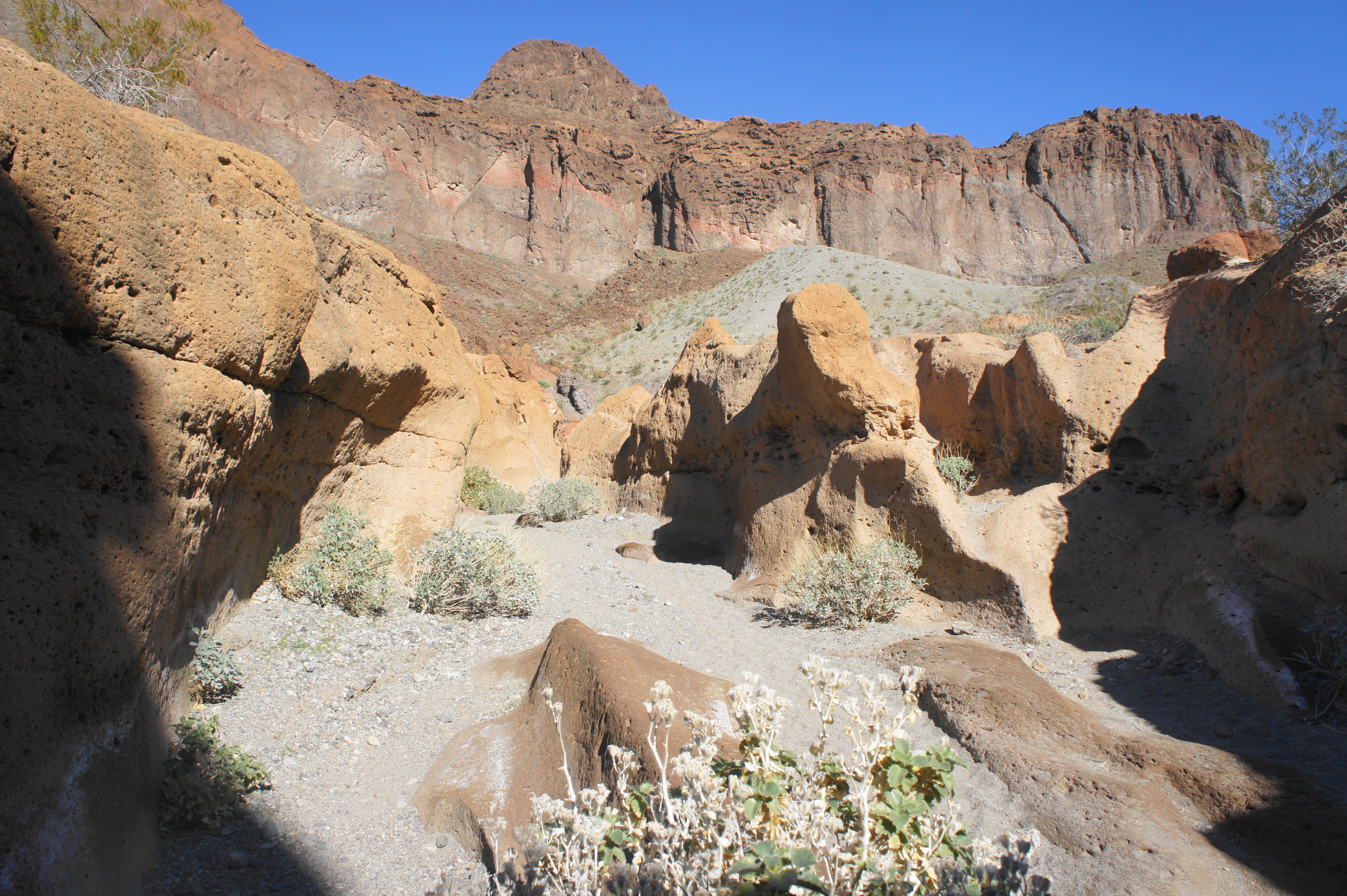
After a wide opening, the wash cuts through a scenic narrow section featuring dark, shaded walls and a six-foot chockstone that is bypassed via a rock pile on the right. Just beyond, at about 4.1 miles, a well-trodden path leaves the wash to the right, cutting off a bend in the canyon. The path then drops into the wash again, but this time only crosses it, leading to an uphill trail on the north bank. Hikers can continue onward up the canyon, but the upper reaches of Hot Spring Canyon are more technically difficult, requiring two class-4 climbs.


Most hikers, therefore, opt for the “saddle route,” which leaves the canyon bottom and climbs steeply—but safely and free of technical climbing—back to the trailhead. The dusty single-track is well-worn and easy to follow as it leaves the wash, ascending gradually at first.
After following a side canyon for 1/3 mile, the incline steepens as hikers make way for the high saddle in the full sun. Looking back, the canyon melts away, replaced by views of a prominent butte that sticks out like a thumb in the desert landscape. As hikers climb higher, the butte itself appears smaller and smaller, dwarfed by the much higher escarpments beyond.

Finally, at 4.6 miles, the Hot Spring Canyon Trail crests the saddle, revealing views of Highway 93 and the distant Black Mountains beyond to the east. What goes up must come down; thus hikers descend from the saddle via a winding track that quickly becomes a muddle of intersecting paths. Effectively any route works, as long as it is heading in a northeasterly direction, back toward the highway and trailhead.
Over five miles from the start, the route returns to the initial wash, and the turnoff to White Rock Canyon appears again on the left. Continue straight for a half-mile, passing the initial signs and under the highway again before the final climb back to the trailhead and parking lot.
The White Rock Canyon-Arizona Hot Springs Trail Loop is at least a half-day’s trek. Quick hikers can complete in three hours, while slower walkers and/or those hoping to soak in the hot springs should allot at least 4-5 hours for the 5.75-mile round-trip. In any case, the hike is one of the best in the region and a sure treat for visitors to the Las Vegas area.

We were quite lucky to hike this a few years back and there was not one person on the trail. A group of Bighorn sheep followed us down to the river. They kept peaking over the the high walls to check on us. We didn’t use the hot springs but enjoyed the walk through them. Loved the hike out to make the loop. This whole area is now closed now because of the virus. They also close this area from mid May to mid Sept because of the heat. They got tired of rescuing stupid tourist so now it is closed in summer.
That’s right, this is virtually in your backyard now, right? When you’re not travelling, of course!
I’m so happy to have found your blog! Your detailed trail descriptions definitely draw the reader in and no doubt (as I go down the rabbit hole on your future posts) will have me adding many, many trails to my hiking wish list.
Thanks for the gorgeous pictures. I really like the look of the hot springs. Would you say you need to be in good shape to make it back and forth to the springs?
Hi Geri – it’s not too bad no. The only steep section is the the exit back to the trailhead, and the connector section requires careful footing, but it is not horrible. There are lots of families with kids that make it out there and back.
Is it possible to do this loop with a dog? (~50lbs, very athletic)
Probably – it is allowed, I believe, though not sure how they would react to the hot water in the hot springs!
Pingback: Top 10 Hikes in 2020 | Live and Let Hike
Local guide here. The main reason why most people go down the hot spring trail (the reverse of your entire trip) is because of the rapid elevation gain. Hiking UP the hotspring trail is considerably much more difficult than going up white rock canyon. It is shorter on that trailhead but will take considerably much longer time & strenous even for a seasoned hiker to go the way you have detailed. I would only attempt this route during the coldest part of the year.
Pingback: Top 10 Hikes in 2021 | Live and Let Hike
Hi,
Love your blog!
Do we need a timed entry pass? We have done this 2x over last 25+ years and can’t recall. Please advise. If we do, kindly provide a link. Thank You.
Hi Beth – no as far as I know you do not need a timed entry for Lake Mead. Best to get there early though to beat the crowds! Weekdays are also good – we just did nearby Goldstrike Hot Springs (blog forthcoming) and nearly had the place to ourselves on a Thursday morning.
Great news! Thanks, Andrew.
Pingback: Goldstrike Canyon Trail (Lake Mead National Recreation Area, NV) | Live and Let Hike