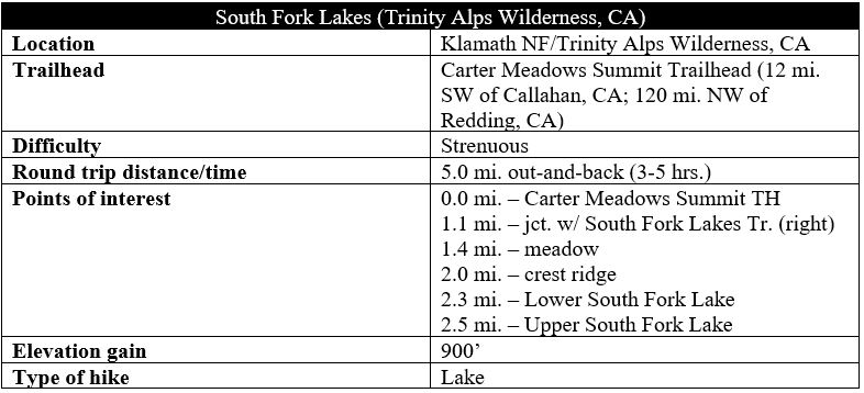
Short hikes to the majestic alpine lakes of northern California’s Trinity Alps Wilderness are relatively difficult to come by, as distance and elevation gain puts many of them out of reach to day hikers. Even rarer are trails accessible by way of only paved roads – the vast majority require braving gravel tracks of questionable condition, easy for jeeps and SUVs but dicey for your average sedan. That’s what makes the 5-mile hike to and from the South Fork Lakes in the northern Trinities special: a beautiful spot that feels remote and off-the-beaten path, yet—due to its location off paved Cecilville Road (Route 93)—reasonably accessible to travelers. But driving there is the easy part, as the hike itself requires a grueling climb of more than 900 feet in less than 1.5 miles. Hikers are rewarded with majestic solitude at the two alpine lakes, however, increasingly rare as the Trinities—once one of California’s best-kept secrets—sees more and more crowds. (Note: There are also some previously disturbed camping spots at the upper lake for those who seek a short, overnight backpacking trip.)

The hike
Although reasonably associated with the Trinity Alps, the South Fork Lakes are technically situated in the western Scott Mountains, a scenic range that extends more than 20 miles between the Trinities and Shasta Valley. (Note: The Salmon Mountains, which span the Russian Wilderness, are also located just north of here.) Most day hikers will reach the lakes by way of the Carter Meadows Summit Trailhead, situated atop a high pass between the Salmons and Scotts in Klamath National Forest, 12 miles southwest of the sleepy town of Callahan on Cecilville Road (Route 93). (Note: Through-hikers on the Pacific Crest Trail, however, may also visit South Fork Lakes as a short detour.) Park at the small lot at the trailhead at about 6,150 feet in elevation.
Carter Meadows Summit is a waypoint on the 2,650-mile Pacific Crest Trail (PCT), which passes through the trailhead and serves as the initial thoroughfare for day hikers heading to the South Fork Lakes. From the trailhead, head south into the conifers, staying left as the Hidden Lake Trail bears right. (Note: The 2-mile round-trip trip to Hidden Lake is even shorter but less rewarding than South Fork Lakes. It has been described as “the easiest trail in all of the Trinity Alps.”) From here the PCT begins to descend at a modest clip, hugging a hillside as it enters the Trinity Alps Wilderness, a more than 500,000-acre wonderland of granite crags, thick forests, and remote alpine lakes.
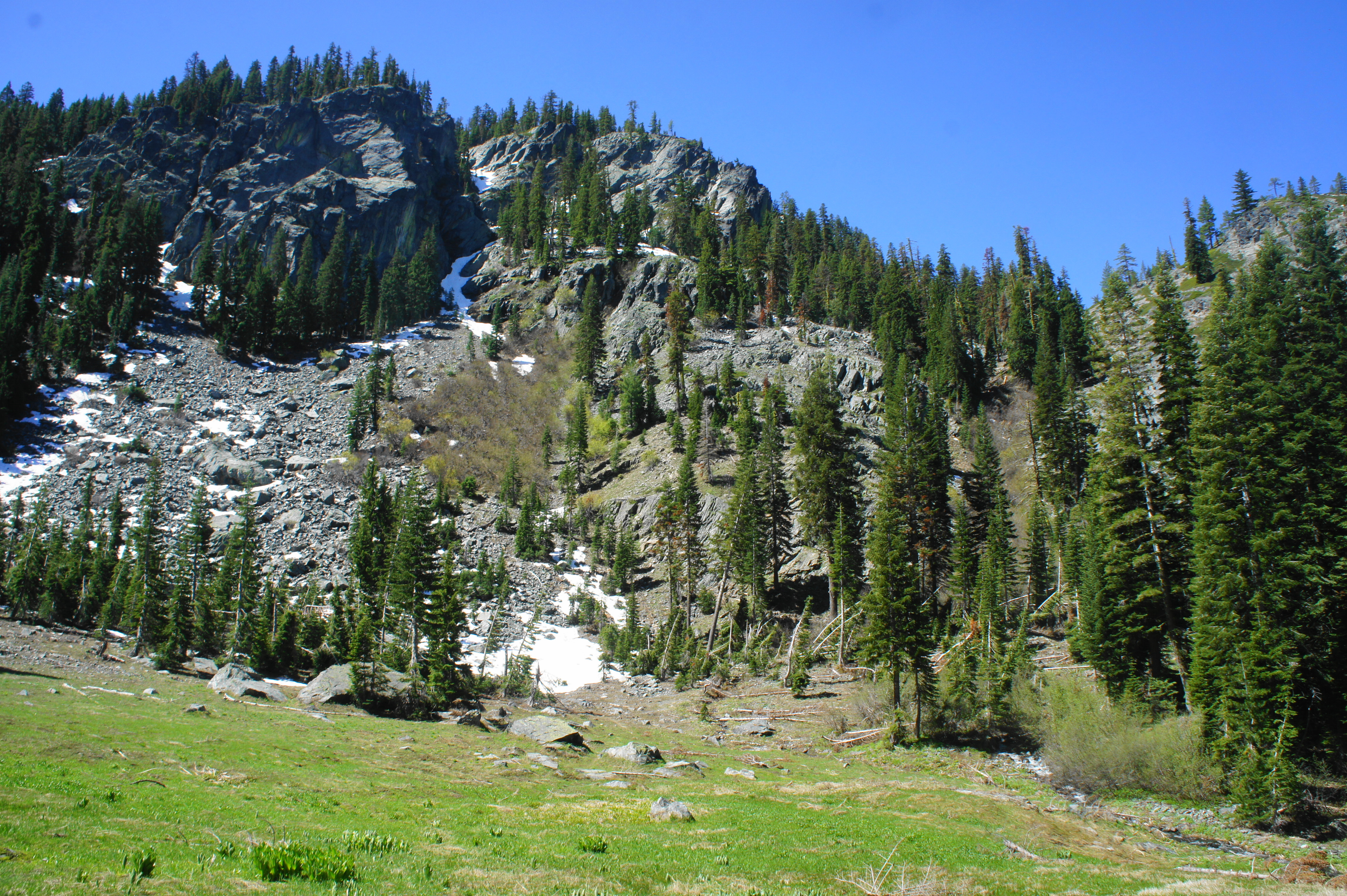
From here the descending trail approaches the upper reaches of the Scott River watershed. Briefly emerging out of the trees, hikers get a glimpse of the stony divide to the south. The prominent knob in the middle is an unnamed peak at 7,166 feet, low compared to the Sierra Nevada but high enough to be surrounded by snow until late spring. The high notch that contains the South Fork Lakes remains just out of view to the right, behind a towering crag of 7,450 feet.
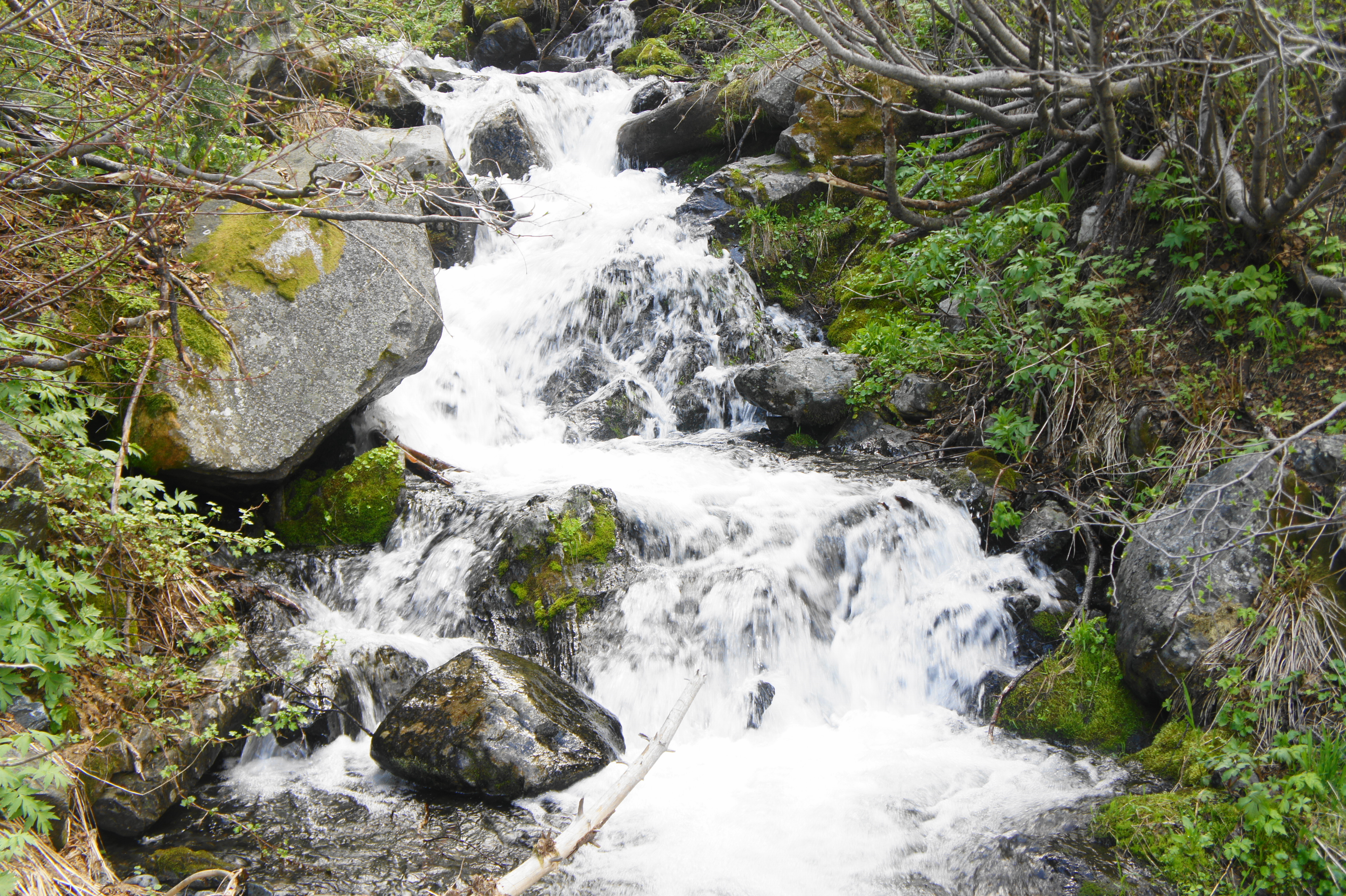
At about 4/10 mile, hikers reach the first of several stream crossings. In late spring or early summer, expect water levels to be high enough to get your feet wet – so plan to bring hiking sandals or waterproof boots. Just beyond the tumbling creek, the incline eases, but the trail continues to shed elevation—a loss that will be made up in earnest in the steep ascent to come.
Just short of the one-mile mark, the trail crosses a second stream—this is the South Fork of the Scott River, which is fed by the South Fork Lakes and nearby snowmelt and flows all the way down to Callahan and the Scott Valley. High volume brings rushing cascades, beautiful and picturesque in late spring. This crossing is arguably easier than the first, although, again, be prepared for wet feet.
Beyond, the PCT begins to gradually climb, abruptly reaching a junction with the South Fork Lakes Trail at around 1.1 miles. The spur trail is not marked, but a sign on the opposite side of the trail—which indicates distances on the PCT to Carter Meadows and Scott Mountain—marks the junction.
Bear right on the South Fork Lakes Trail, which almost immediately starts to climb amid thick woods. Hikers will cover about 900 feet in elevation gain in the next 1.4 miles. After a reasonably mellow ascent through the forest, the canopy opens up into a beautiful meadow, about 1.4 miles from the trailhead. The grassy patch is rather boggy, especially after recent snowmelt.
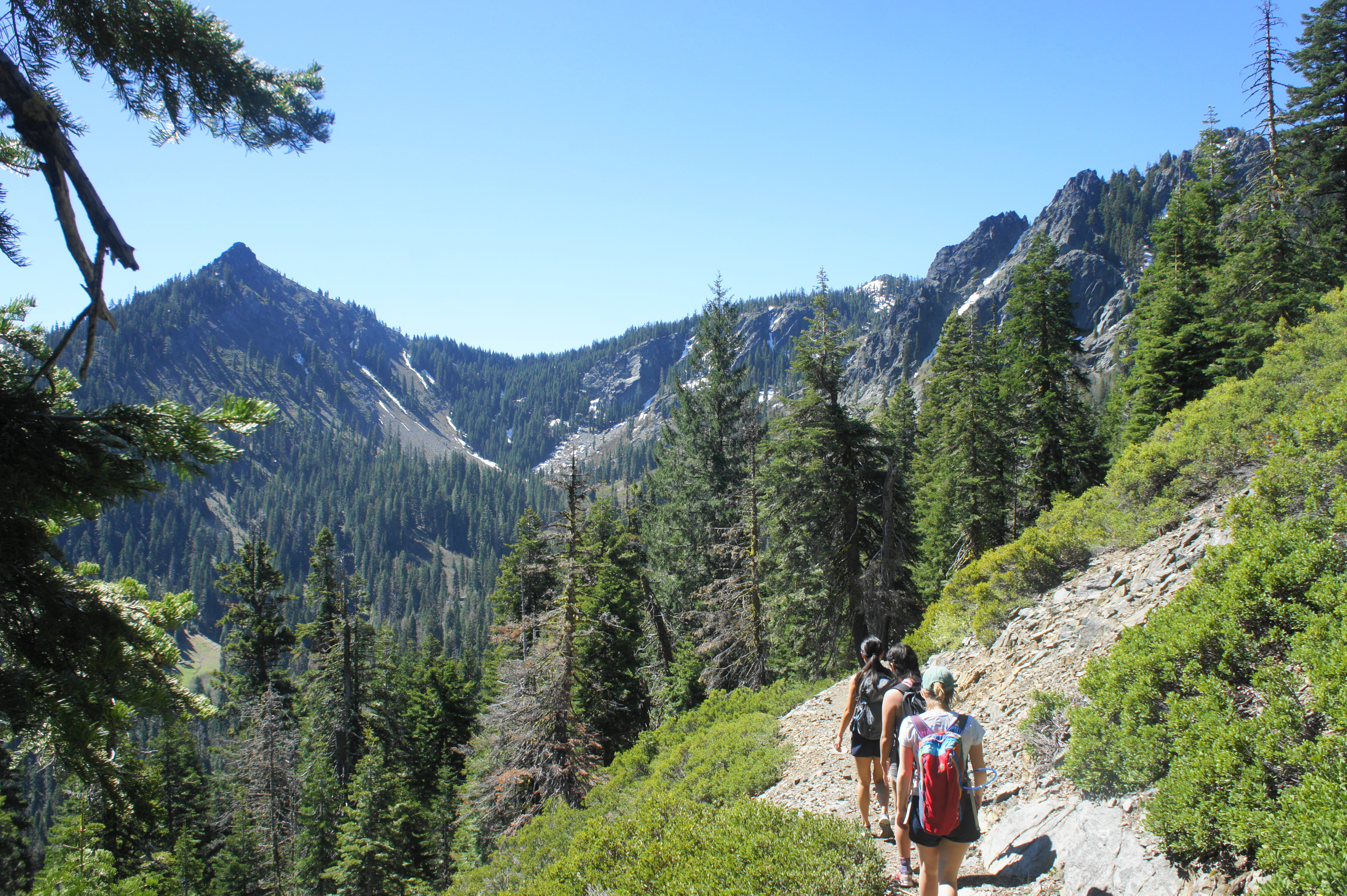
It is at first unclear which way the trail goes from here, but hikers should eventually catch sight of the tread heading off to the right, crossing two forks of the river that both require some modest rock-hopping. An imposing granite slope stands between you and the lakes, ushering in a brutal climb for the next half-mile that is one of the toughest in the Trinities.

The ascent begins by switchbacking up a pine-studded pitch, then traverses a relatively level willow patch that is fed by numerous springs. Here hikers are briefly distracted by the open views down the South Fork valley toward Callahan before the trail exits the brush and resumes its steep climb. The next section features loose rock and some decent exposure as the South Fork Lakes Trail approaches a scenic outcrop at about 1.8 miles. Here there may still be some snow early in the summer season.

The final ascent is the steepest, abandoning switchbacks in favor of a straightaway pitch that is likely to leave even experienced hikers huffing and puffing. But, at last, at about two miles, the path levels off and crests a high saddle, revealing another wooded basin ahead. From here it is a quarter-mile of relatively level and easy walking to the first of the two lakes—Lower South Fork Lake.

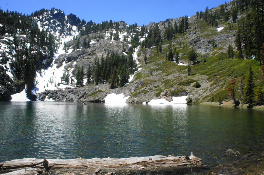
The first lake is smaller and less scenic than the second, but it is worth stopping to admire the beautiful stillness or try to spot fish swimming along the shallow shores.
Technically the ongoing trail skirts the western shore of the lake, then bears left and eastward, climbing again to the crest of the mountains. However, after clearing the lower lake, hikers will want to divert off to the south, traversing off-trail through relatively brush-free woods for 1/10 mile to reach the ultimate destination: Upper South Fork Lake.

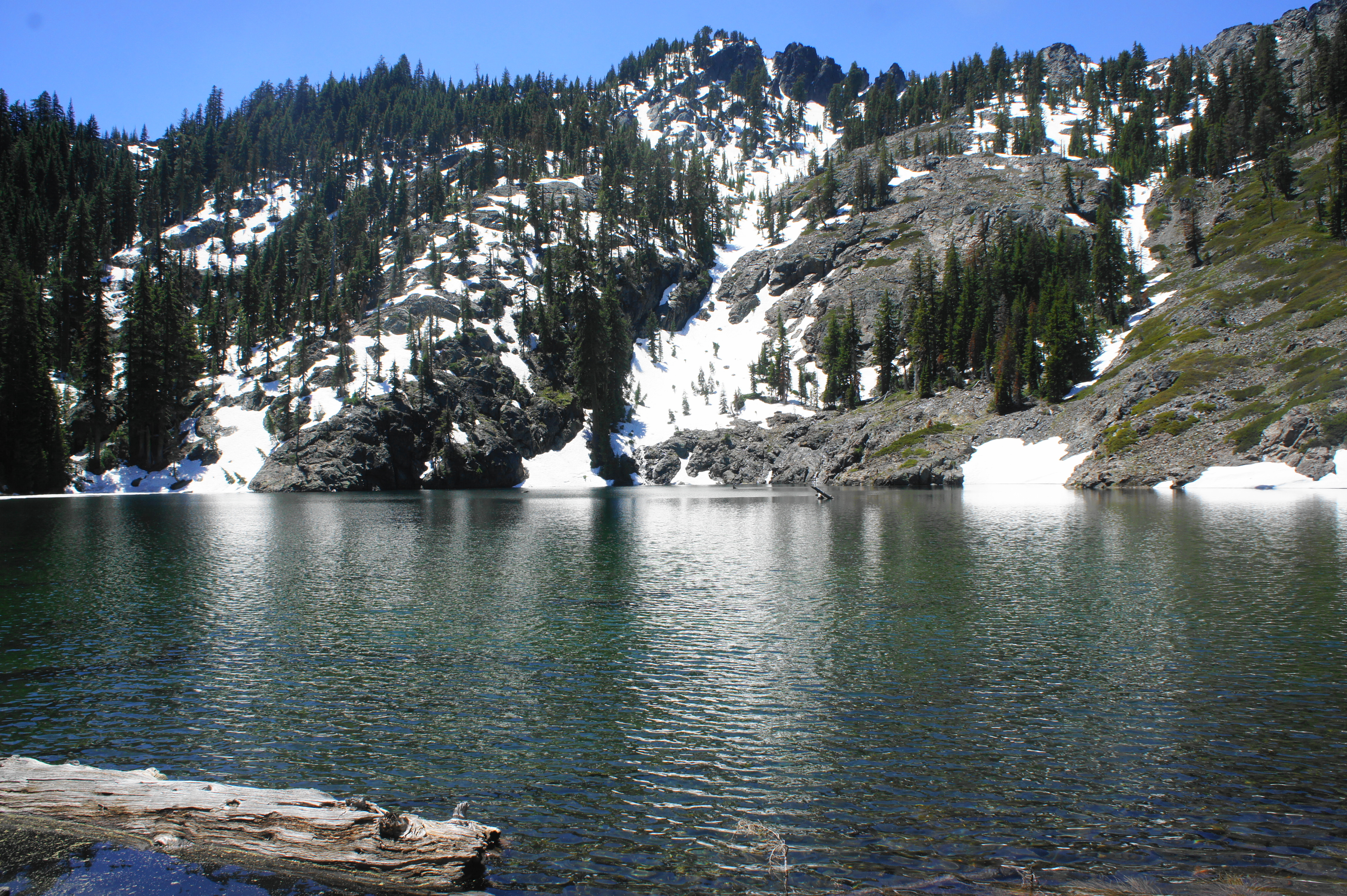
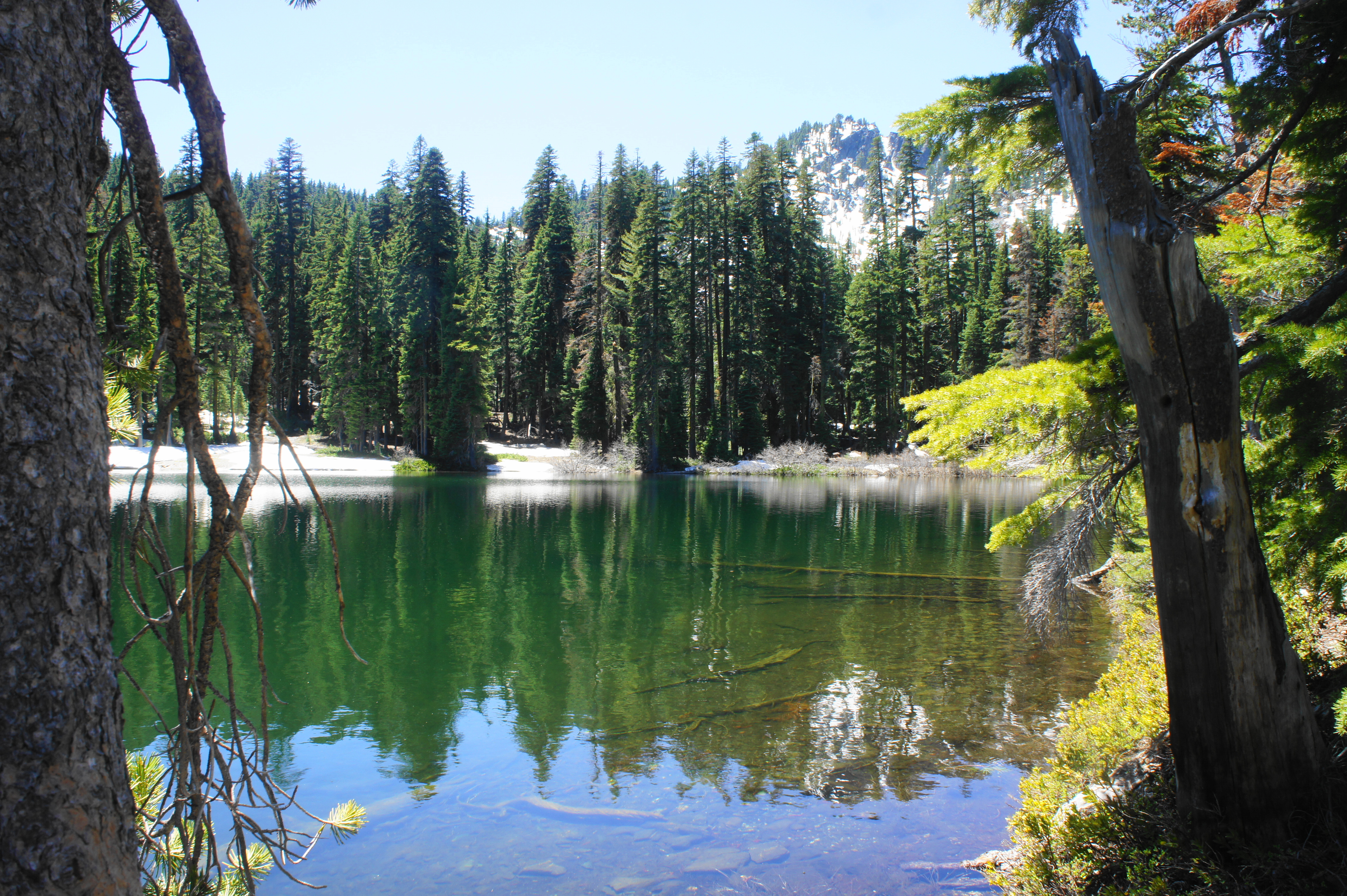
The upper lake, situated in a glacial cirque flanked by stunning granite hillsides, is far more scenic than its lower and smaller cousin. In late spring, snowmelt produces rushing waterfalls that plummet into the chilly waters. The lake is quintessential Trinity Alps: beautiful, serene, and quiet, surrounded by intimidating walls of stone. Brave souls can take a dip in the glacial water—but expect something akin to a polar bear plunge.

Upper South Fork Lake is a nice spot to spend an afternoon—after all, staying awhile makes the steep ascent worth it. But once you are ready to go, return the way you came, tackling the challenging incline in reverse. Once back on the PCT, hikers will suddenly remember the initial descent from the trailhead—which now turns into a nearly 400-foot gain.
Despite the relatively short distance of five miles round-trip, expect this strenuous hike to take upwards of 3-5 hours.

Looks really nice! Beautiful photos too.
just curious where you got your permit, since mt shasta office is closed and weaverville is out of the way
Didn’t stay overnight; it was a day hike. Also I believe Klamath NF is still offering virtual/over-the-phone services despite office closures, and I have seen on the Facebook page that many offices/trailheads are offering self-serve permits.
Pingback: Trail Gulch Lake (Trinity Alps Wilderness, CA) | Live and Let Hike
Pingback: Terminal Geyser, Little Willow Lake, & Boiling Springs Lake (Lassen Volcanic National Park, CA) | Live and Let Hike
Thanks for sharing information about this more remote part of NorCal! Sounds like a great place to get away!
Pingback: Top 10 Hikes in 2020 | Live and Let Hike
going this tueday may .first hike of the year call me want to go