
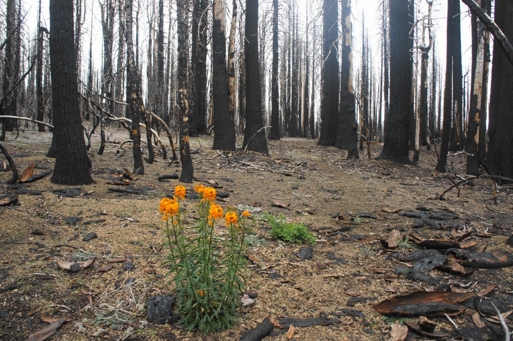
At 7,056 feet, Snow Mountain is, as the crow flies, the closest peak above 7,000 feet to the San Francisco Bay Area and one of the tallest in California’s Mendocino Range. Relative proximity to northern California’s major population centers, however, has hardly spoiled this peaceful wilderness, still unknown to many despite its recent inclusion in the Bureau of Land Management’s Berryessa Snow Mountain National Monument. What has partly spoiled the area are wildfires: in 2018, the Ranch Fire ripped through the Mendocino Range, devastating much of the 60,000-acre Snow Mountain Wilderness. (Note: As of mid-2020, many trailheads, recreation sites, and campgrounds in the area remain closed because of fire damage.) While some stretches of forests were burned, many pockets of life remain, and the burned areas are gradually healing as wildflowers blanket the ground and new growth begins to emerge.
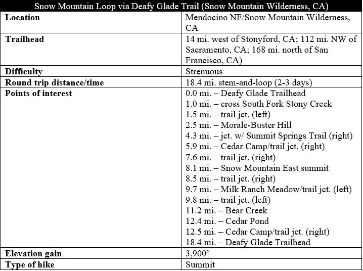
While visitors can bag the summit of Snow Mountain in one long, very strenuous day hike, the ascent is much more enjoyable as a 2- to 3-day backpack. Below I describe such a trip, starting and ending at Deafy Glade Trailhead in Mendocino National Forest, which forms an 18-mile lasso-loop that traverses forest, streams, spring-fed meadows, and high slopes with panoramic vistas of one of California’s forgotten landscapes. Unlike existing descriptions on the web, this post includes a loop option that continues past the summit to Milk Ranch Meadow and the Bear Creek area, an extension that sports expansive views and hidden glades that are well worth a few additional miles. (Note: Snow Mountain technically has two summits—a west and east peak. This description hits the east (taller) peak, but the west is easily accessible.)
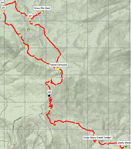
The entire trek gains nearly 4,000 feet in elevation, most of it in the first six miles, making this no easy walk in the park. The loop portion is far milder in terms of elevation gain; experience with reading topo maps and route-finding, however, is a must. (Note: Do print out and bring this excellent map from the Snow Mountain Hiking Association!)
(A few notes: (1) No wilderness permits are required for overnight trips in Snow Mountain Wildnerness. (2) This is bear country! Bear canisters are suggested though not required. (3) One challenge for overnighters can be finding a reliable water supply along the way—unless it is very late in the season (e.g., September-October), however, there should be several places to treat/filter water; I have marked several options, with varying flows, on an interactive map here. See also the helpful topo map here, which includes marked water sources. (4) Finally, it is not called Snow Mountain without reason, but the white, fluffy stuff is generally clear by late spring/early summer. Check the USFS site for latest conditions.)
The hike
Deafy Glade Trailhead is a mere two-hour drive from Sacramento and three hours from the East Bay, although it certainly feels longer. For all but the heartiest dirt road drivers (who may approach from the west), visitors will enter Mendocino National Forest from the east. From Interstate 5 in the Central Valley, take Exit 586 for Maxwell, then continue for 31 miles westward to Stonyford, a small town nestled in a minor valley at the foot of the Mendocino Range, a section of the broader Coast Range.
Just north of town, take a left on Route M10/Fouts Springs Road and follow the slow and winding track for 13 miles to the trailhead. Passing numerous pull-offs and campgrounds primarily used for off-road vehicles, the road eventually enters thick forest along the north flank of Potato Hill. At 13 miles, the pavement abruptly ends, turning to dirt. This is your cue; park along the small pull-on the right. Although not signed (there is a wooden information board that is blank), this is Deafy Glade Trailhead. (Note: On weekends, expect there to be a handful of cars at the trailhead; on weekdays, it is not unlikely to have the place to yourself.)
(Note: It is possible also to continue further, onto the dirt track, to start the hike at Summit Springs Trailhead. Starting here cuts about 3.5 miles each way off the stem-and-loop. However, as of mid-2020, the Summit Springs parking area was closed, and, even in good times, the route is not recommended for standard, two-wheel drive vehicles.)
From the trailhead, one can see the hulking mass of the Snow Mountain complex, although the summit is out of view. The high outcrop visible from the trailhead is High Rock (6,329’), a prominent waypoint on the hike—but a full 700 feet lower than the actual summit.

Deafy Glade Trail to Summit Springs Junction (4.3 mi.)
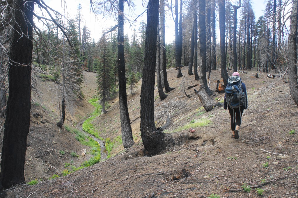
At the trailhead, be sure to sign at the trail register, and pack plenty of water and supplies for the hike, which enters remote wilderness quite quickly. The hike begins with relatively little fanfare, gradually descending an old logging track, contouring westward. The valley below was carved by the South Fork of Stony Creek, a perennial waterway that you will encounter soon. This area appears to have been partly spared by the recent fires—a variety of conifers grow tall and deep. About 250 yards from the start, follow a short single-track around a stony ravine, then continue on the old road again. Technically there is a junction at about 0.35 miles, but the trail coming in from the right is largely indiscernible.
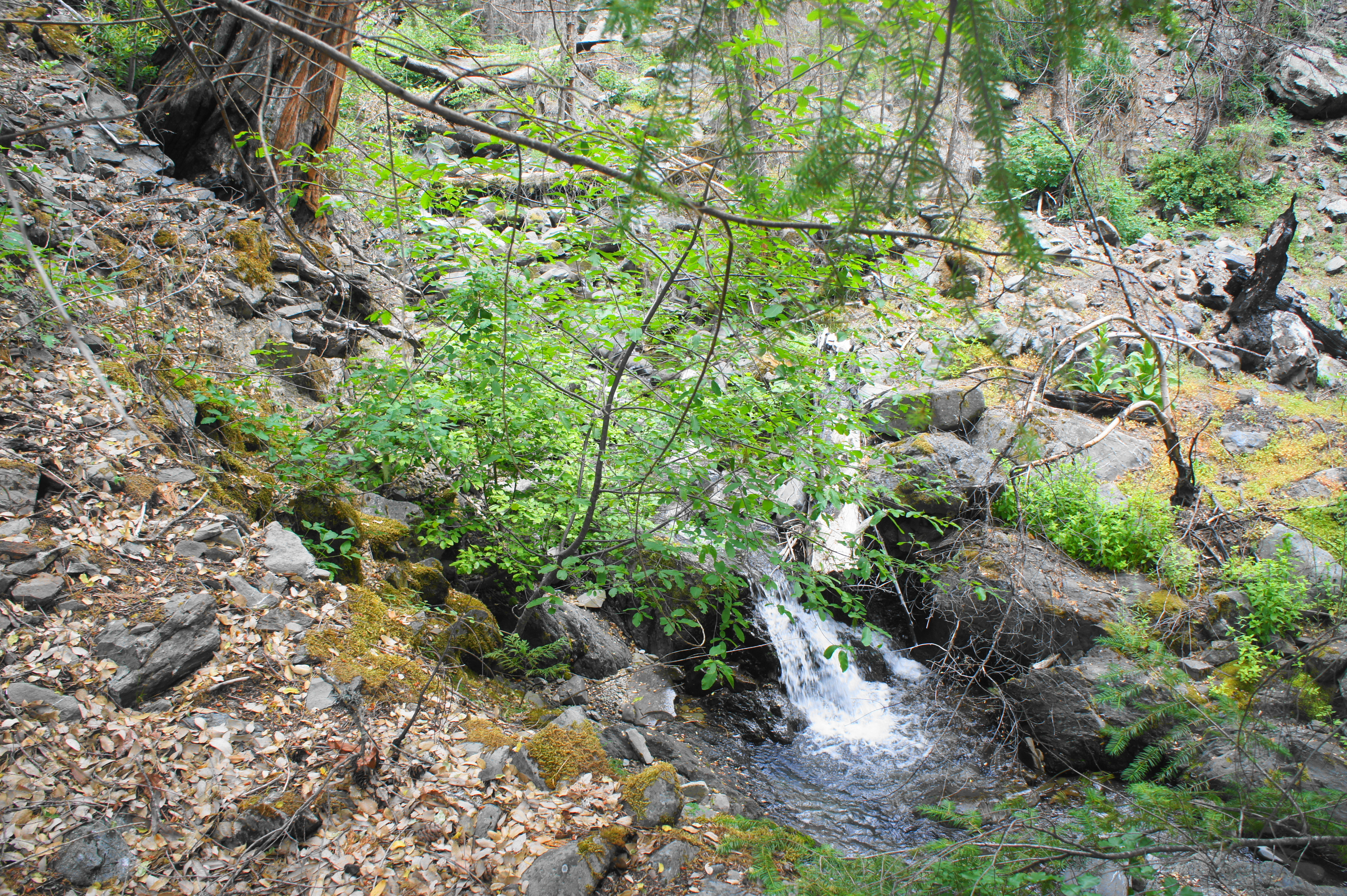
Around a mile into the hike, the gradual descent turns abruptly steep. With obscured views of the behemoth of Deafy Rock off to the right, the Deafy Glade Trail drops to a crossing of the South Fork of Stony Creek. This lush and beautiful area is situated at the confluence of the main creek with a prominent tributary, which tumbles down a nice set of cascades.

There is no bridge at the crossing, so prepare for either some masterful rock-hopping or a brief foot bath. In spring or after storms, water levels can rise to as high as waist-deep. (Note: As of June 2020, however, the depth was about 1-1.5 feet, just short of knee height on yours truly.) While there are several spur trails, the key to avoid getting disoriented is to cross immediately as the trail drops to creek level. The Deafy Glade Trail continues along the north bank.
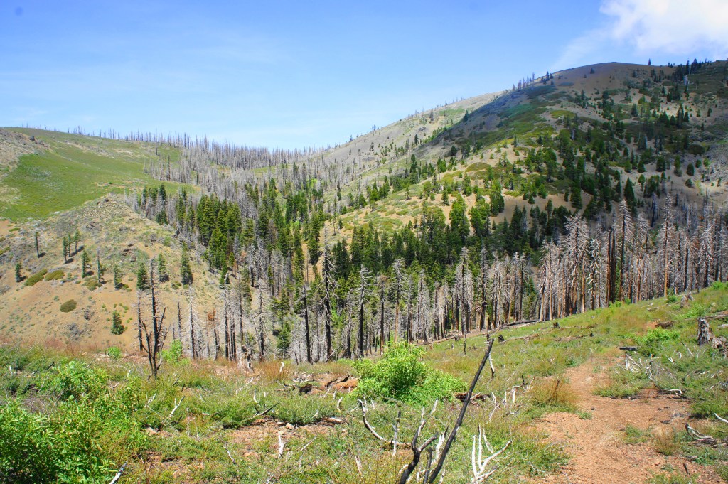
Enjoy the stream while it lasts—this is the last steady flow one will encounter for a while. It also marks the start of the 3,300-foot climb to Cedar Camp, the toughest stretch of the entire hike. The ascent begins immediately, climbing steeply to an overlook of the cascading tributary, then jerking left. As the single-track path exits a side ravine and skirts the hillside, views briefly open up to the south and west. The tree-covered hulk to the south is Letts Ridge, a relatively rarely visited area in Mendocino National Forest.
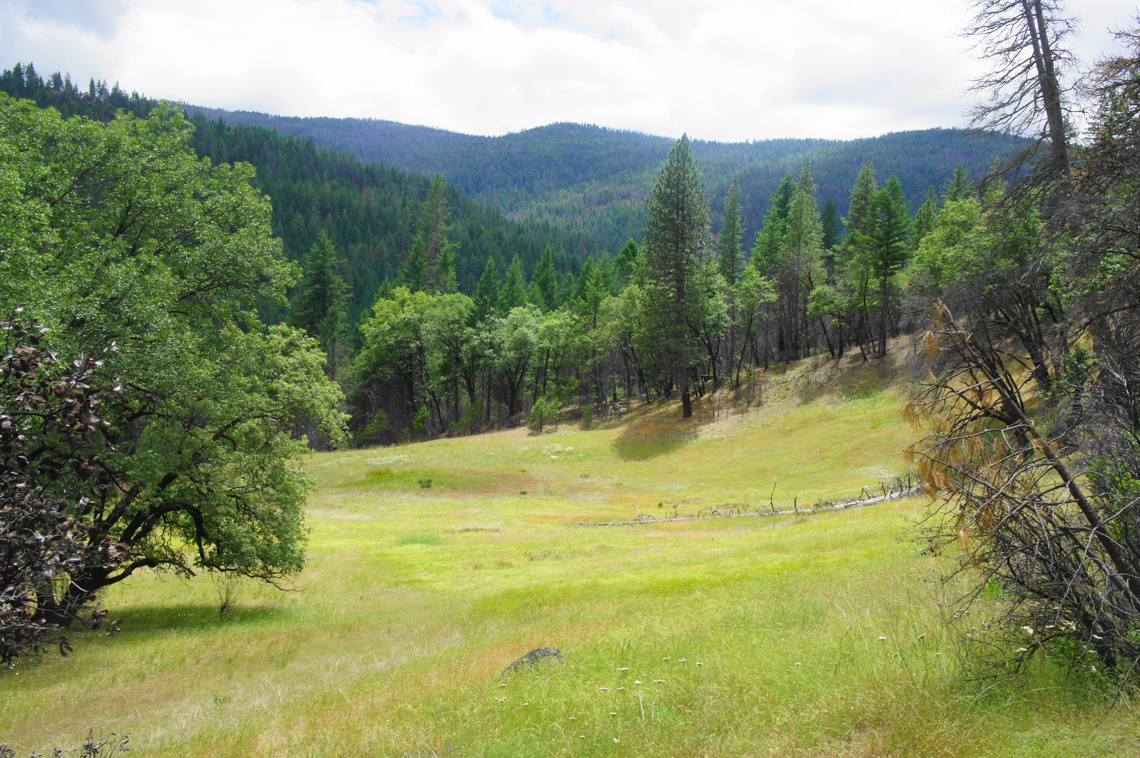
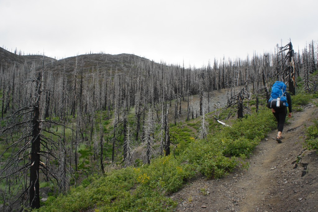
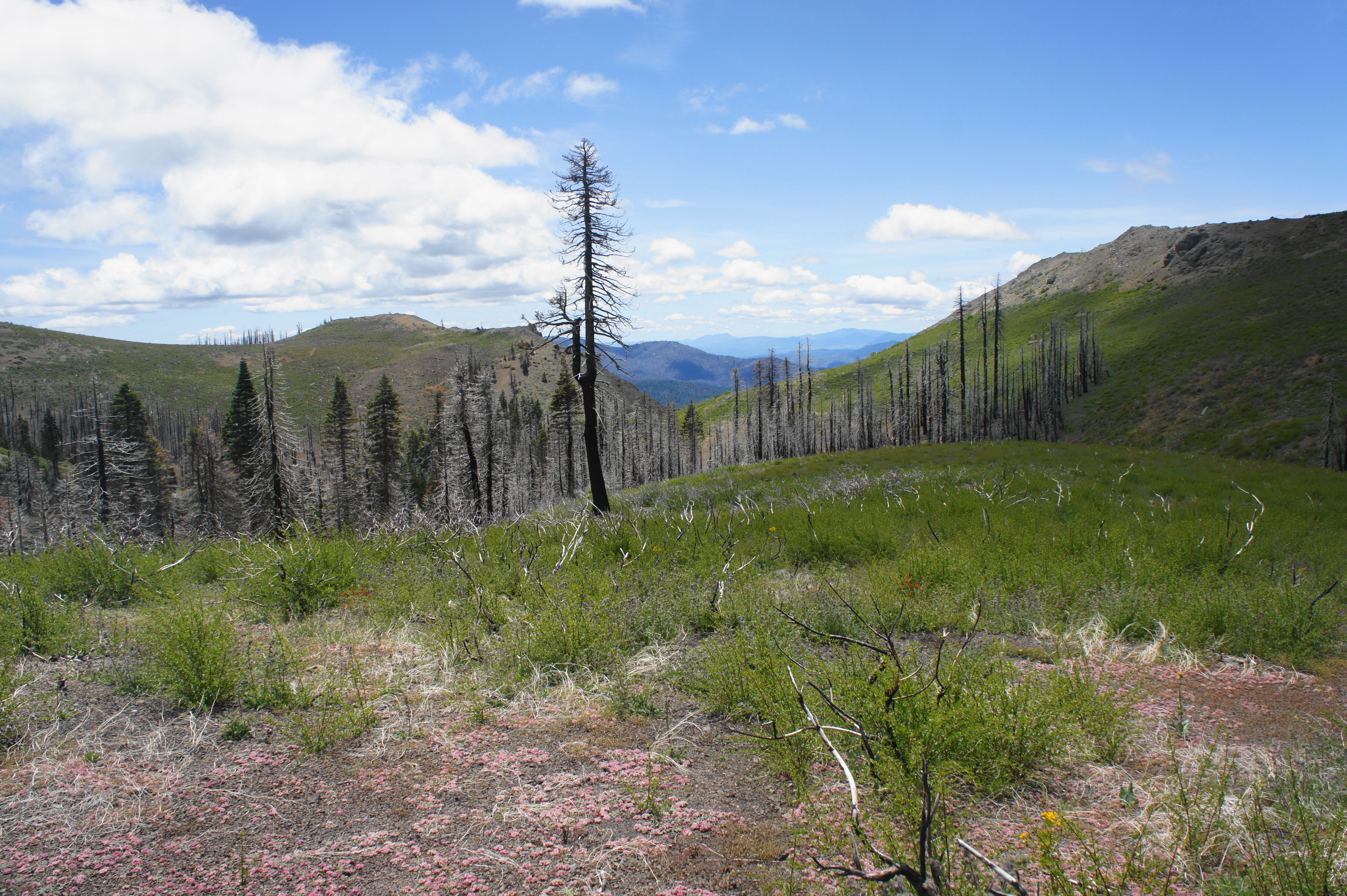
As the trail curves north, the incline steepens to a crushing 25 percent—which does not sound like a lot until one experiences it in person. The woods beyond were hit hard by the Ranch Fire, as attested by the charred remains of small manzanitas along the trail. Some pines and manzanitas, however, have survived, offering continued shade on a hot, sunny day. After briefly levelling off at 1.25 miles, the trail comes into view of its namesake Deafy Glade, a beautiful grassy meadow on the right, then climbs again to a point where it crosses the open clearing. These pretty meadows are one of the touchstones of the hike; hikers will encounter several nice glades in the Snow Mountain area. (Note: There a couple of nice, previously-used campsites at Deafy Glade; backpackers seeking to complete the entire 18-mile loop, however, should continue onward.)
As the trail bears north, it follows a deep ravine on the right, which culminates in a crusty drop-off at about 1.5 miles. Hugging the rim on the left, the path approaches a signed junction. The largely-defunct Smokehouse Trail continues straight, while the Deafy Glade Trail bears left toward Snow Mountain. Take the left turn.


The subsequent section gains about 2,000 feet in elevation in less than three miles. The initial climb from Deafy Glade will feel relatively mild for day hikers—but those carrying heavy packs will start to feel the burn as the grade steadily ascends amid spotty patches of pines, manzanitas, and oaks. Around two miles from the trailhead, the gradient steepens, and the trail enters a more densely wooded area. After a brief clearing offers some southward views, the track climbs to a relatively flat area, where the trail becomes more difficult to follow: generally head west through the gut of the wooded plateau, after which the path becomes more visible again.
At 2.5 miles, hikers reach the base of the lovingly-named Morale-Buster Hill, where grades again exceed 25 percent for a brief period. Take it slow and easy, as the loose, finely-grained rocks can precipitate nasty falls. Finally, at 2.75 miles, hikers reach the end of the 25% section and greet a welcome sight: a left-bending switchback. While the trail continues to climb, more frequent switchbacks from here on out make for an easier ascent. After coursing southward for 250 yards, the trail bends right, inaugurating a relatively mild section that begins to offer some limited views down the South Fork drainage.

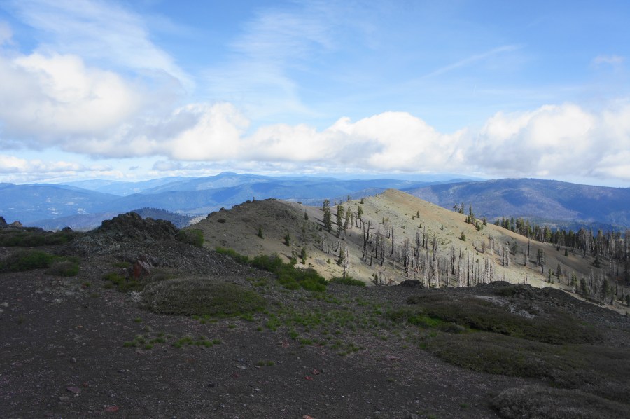
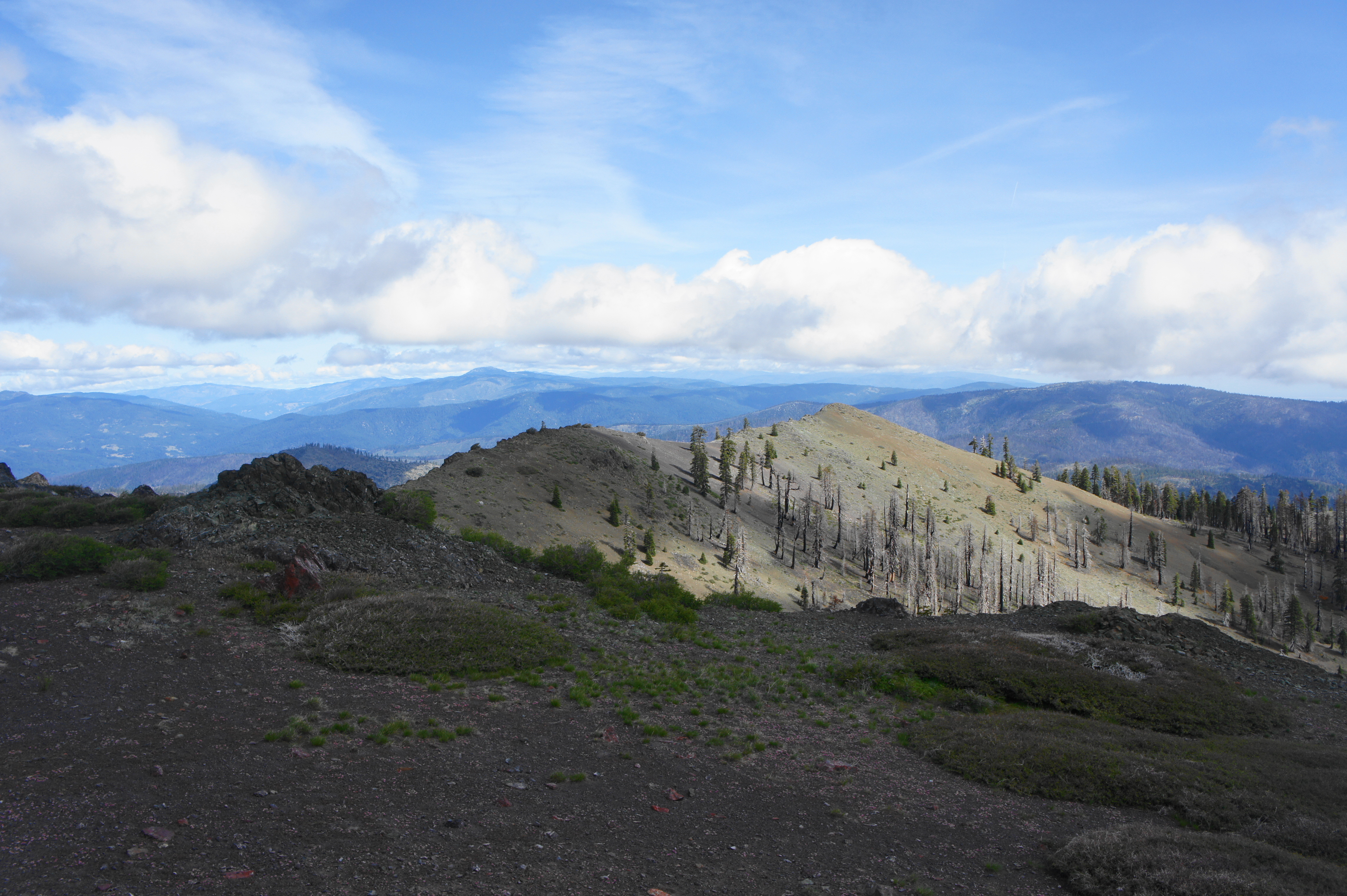
After skirting a grassy ravine at 3.3 miles, the trail climbs to an outcrop that offers the best vistas yet. One can begin to make out the Stonyford area and Indian Valley to the east, with Clark Ridge and the broad Central Valley, the breadbasket of California, beyond.

At 3.5 miles, the trail skirts another ravine that offers the best opportunity for treatable water since crossing Stony Creek. Backpackers who are tired of carrying packs can set up camp around here if they’d like, allowing for the option to visit Snow Mountain on the next day with a much lighter load. Most, however, will continue on, setting their sights on Cedar Camp—another 2.5 miles up the mountain.
After crossing the ravine, hikers officially enter the Snow Mountain Wilderness, a road-less tract of 60,000 acres, one of the larger wilderness areas in northern California. At 3.7 miles, the trail begins to ascend a set of switchbacks. At 4.1 miles, the trail passes through an open section with hundreds of scorched manzanita bushes, a preview of the desolate landscapes to come. Finally, at 4.3 miles, the trail crests a high ridge and reaches a junction with the Summit Springs Trail. (Note: The route to Summit Springs Trailhead comes in from the left.) Hikers are dazzled with westward views across Rice Valley and the Mendocino Range, as well as unobstructed vistas to the south and west.

Summit Springs Trail to Cedar Camp (1.6 mi.)
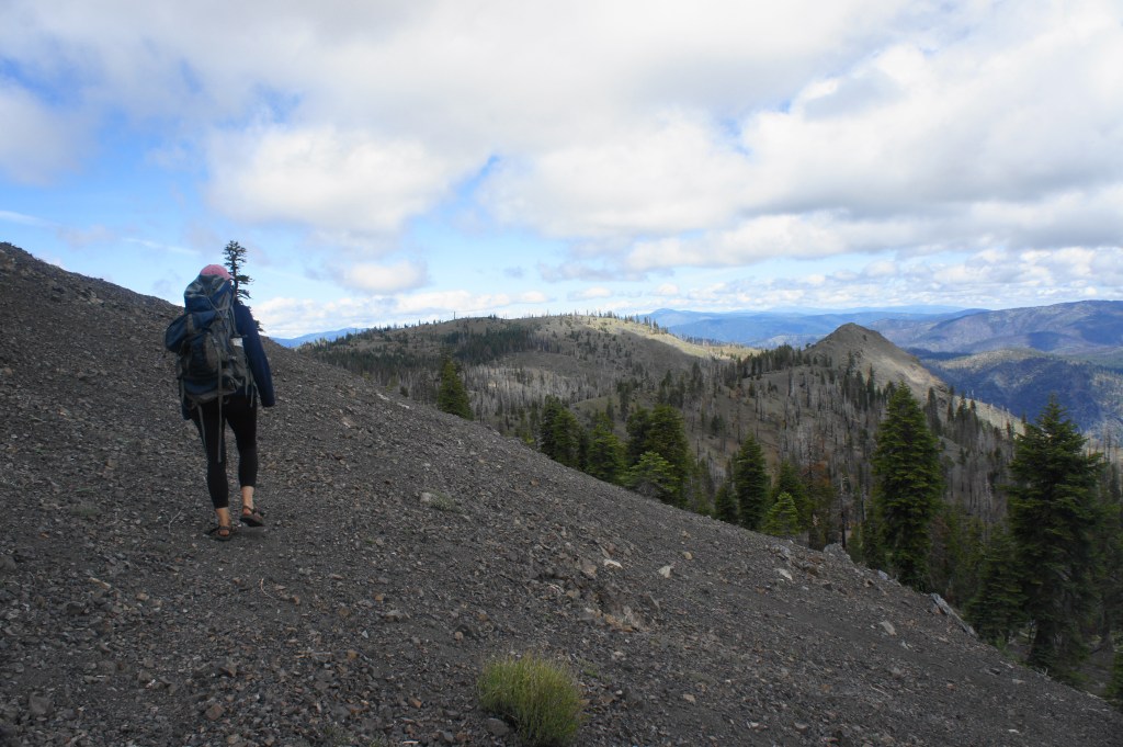
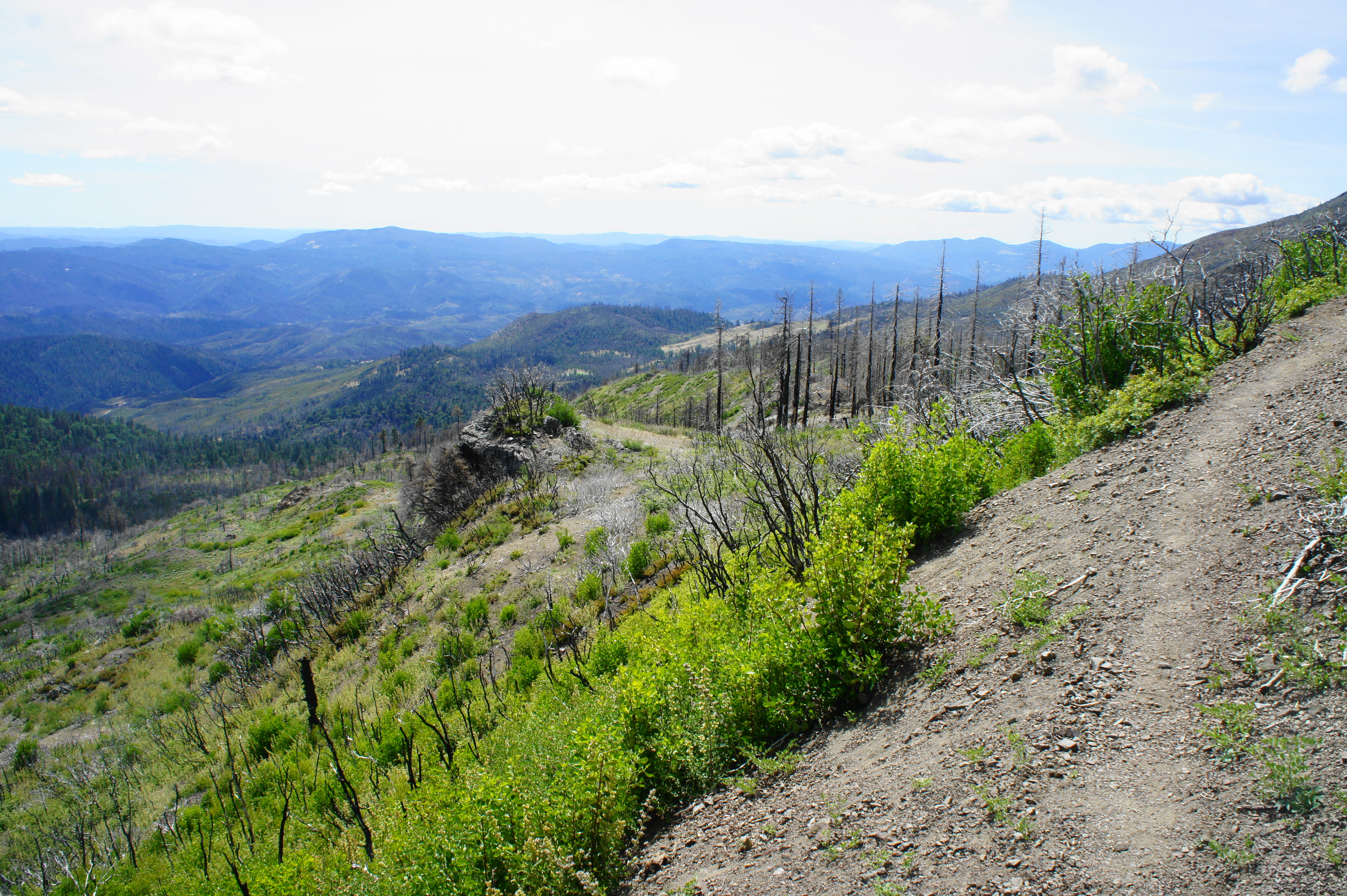
By now the climb to Cedar Camp is more than two-thirds finished, but the best section is just ahead. Ditching the woods below, the onward Summit Springs Trail stays high and sports excellent views westward toward the Pacific Ocean. The behemoth of Snow Mountain extends westward, eventually giving way to Potato Hill (4,405’), with Rice Valley beyond. At the junction, bear right, following the obvious track as it follows the spine of the ridge, then bears left along a steep hillside dotted with scrub oak and brushy manzanitas. While there is significant undergrowth, virtually nothing more than 8 feet tall has survived the latest fires.
At 4.6 mile, the trail passes a rock outcrop and an alluring (though likely windswept) campsite on the left. Sunset from this spot is likely to be excellent. At 4.75 miles, the path rounds a rightward bend and enters a nameless and ghostly ravine. Despite previously passing through burned areas, this is the spookiest thus far: an entire sea of pines, tucked away in a spring-fed gully, reduced to crisp. The eerie feeling is partly soothed by the sight of wildflowers and rushing water, which pours out of a hidden spring.
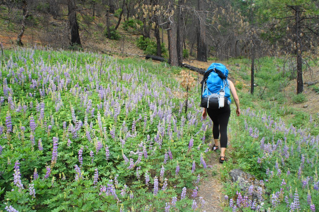
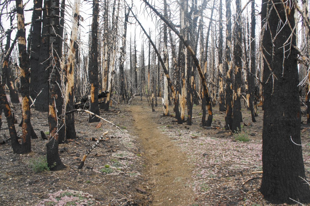
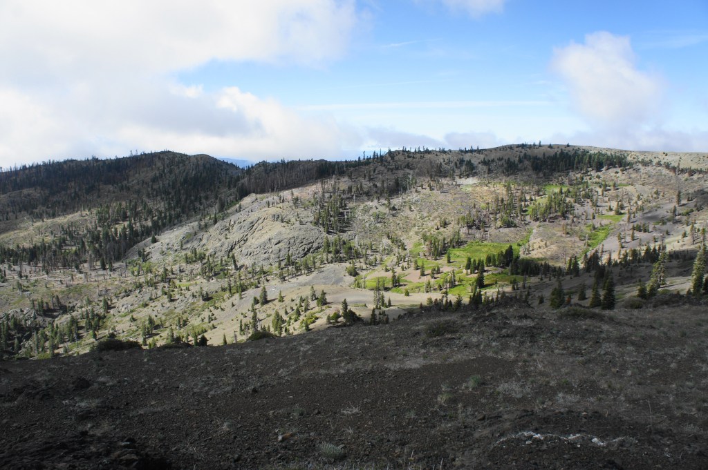
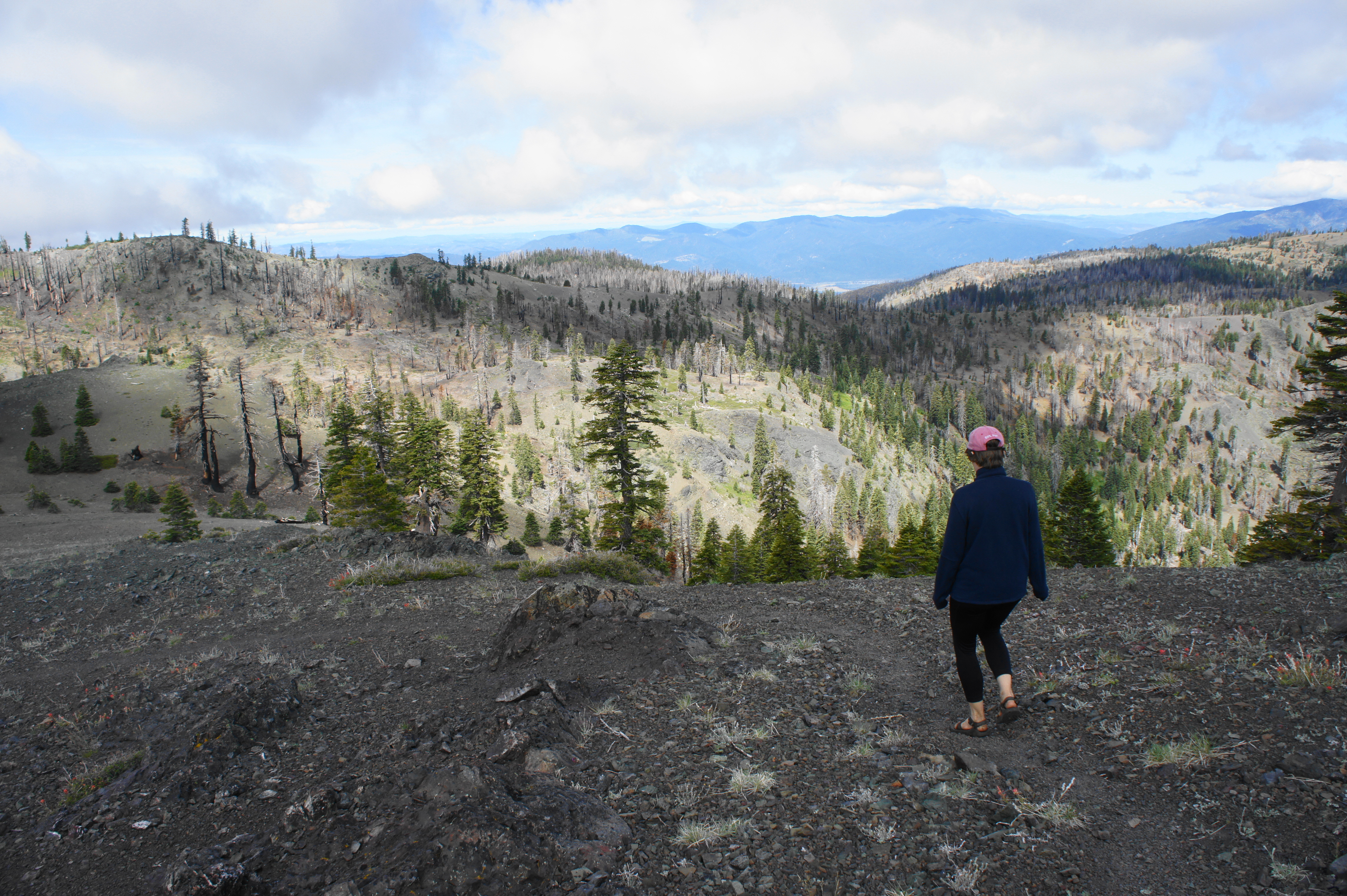
After a relatively level period, the climb resumes in earnest around mile 5. Having now surpassed 6,000 feet in elevation, a bald hillside offers views back southeast by which you came. Then the onward path traverses a high ridge, weaving between several craggy knobs. At 5.7 miles, the trail enters the densest and strangest stand of devastated pines yet. The charred trees are strangely beautiful in their own way, and spring wildflowers—including blankets of pink-and-green pussypaws. (Note: Around here an unmarked trail heads east toward High Rock, but I was unable to find it.)


From here it is a short northward tread to Cedar Camp, an inviting oasis of green amid the hellish landscape. Off to the left is Cedar Pond, a mucky pool that is nonetheless surrounded by a ring of charming corn lilies. Just north of the pond is a popular campsite—if it’s available, take it. (Note: While Cedar Pond is not a great water source, there is a much nicer creek flowing downstream to the west.)


Cedar Camp to Snow Mountain East Peak (2.2 mi.)
After spending the night around Cedar Camp (there are additional sites just west and north of the pond in the woods), prepare to tackle the remainder of the hike to the summit the next morning. Back at the southern fringe of the clearing, there is a junction—it’s not at all obvious at first, but this is the start of the six-mile circuit. Head right (northeast) to take the loop in a counterclockwise direction—after skirting the fringe of Cedar Camp, a better-defined path continues northward through a minor gully. About ¼ mile from the start of the loop, the path begins to ascend through a low gap, then bears left and climbs to a higher saddle at about 7/10 mile.

From here, hikers get their first glimpse of the summit of Snow Mountain—still relatively distant, but only about 400 feet higher than the ridge on which you are standing. The remainder of the route to the summit is highly scenic: after briefly descending from the ridge, the path skirts a beautifully verdant meadow, fed by Dark Hollow Creek. This area, called Summit Basin, is widely exposed to the sun and, in spring, teeming with wildflowers.

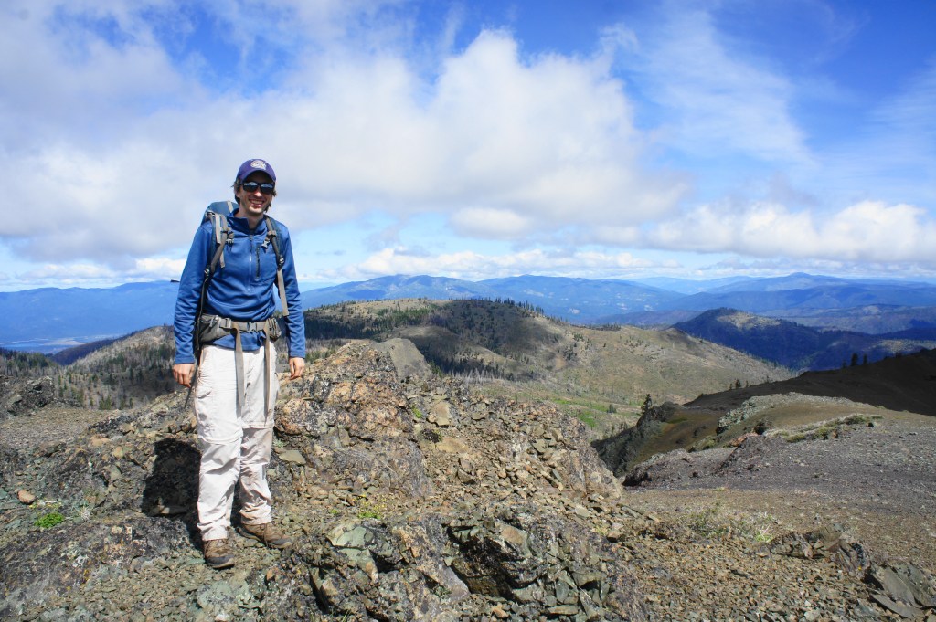
Of course, the climbing is not yet done, and the path begins to ascend steadily again through the pines at around 1.5 miles. After a quarter-mile, the route crests the high saddle between the two peaks of Snow Mountain—bear left to head to the West Peak (7,038’) or right to top the East Peak (7,056’). If one has to choose, pick the East—it is higher, after all, and, on clear days, offers expansive views across the Central Valley as far as Lassen Peak and Mount Shasta.


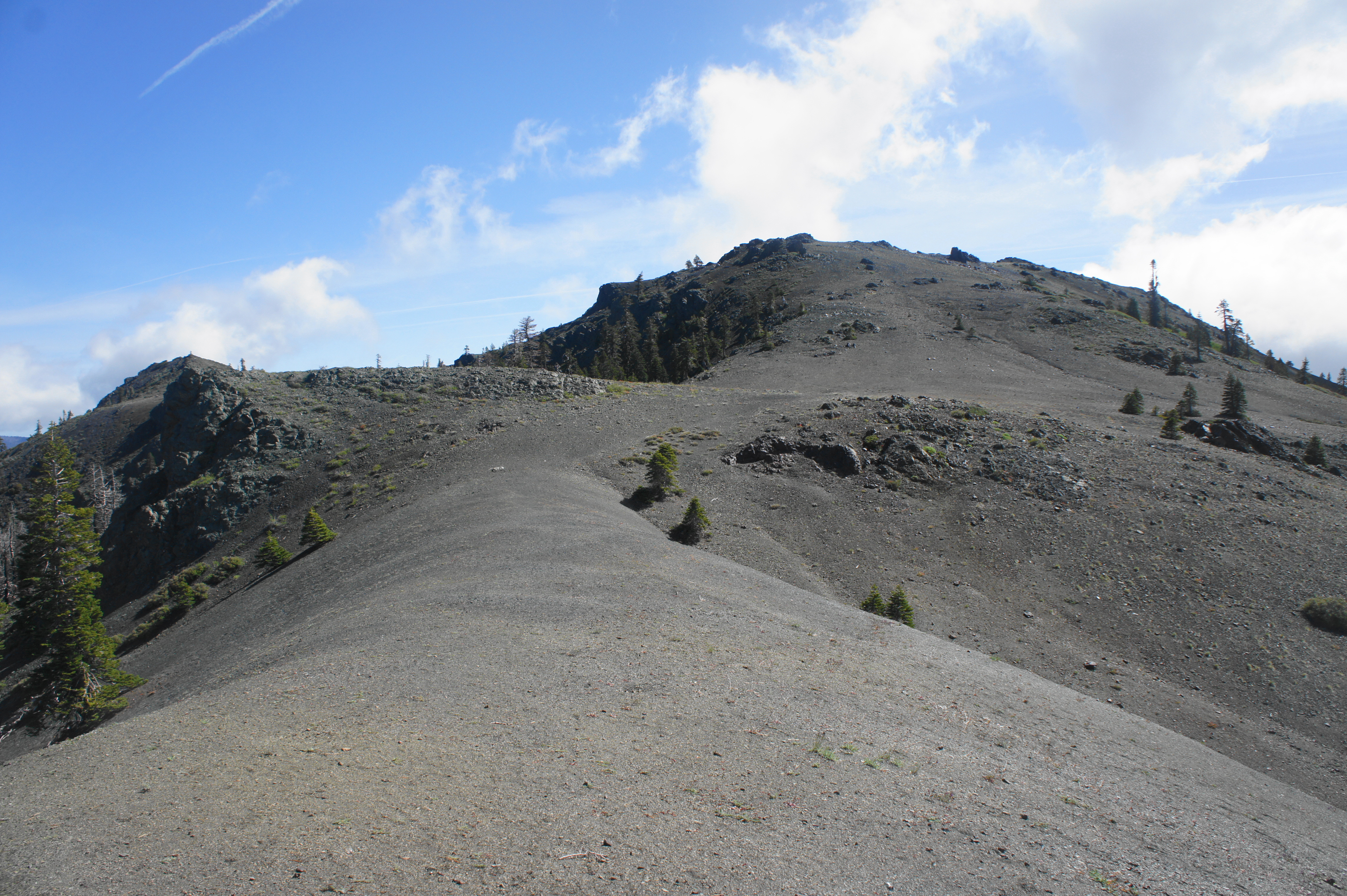
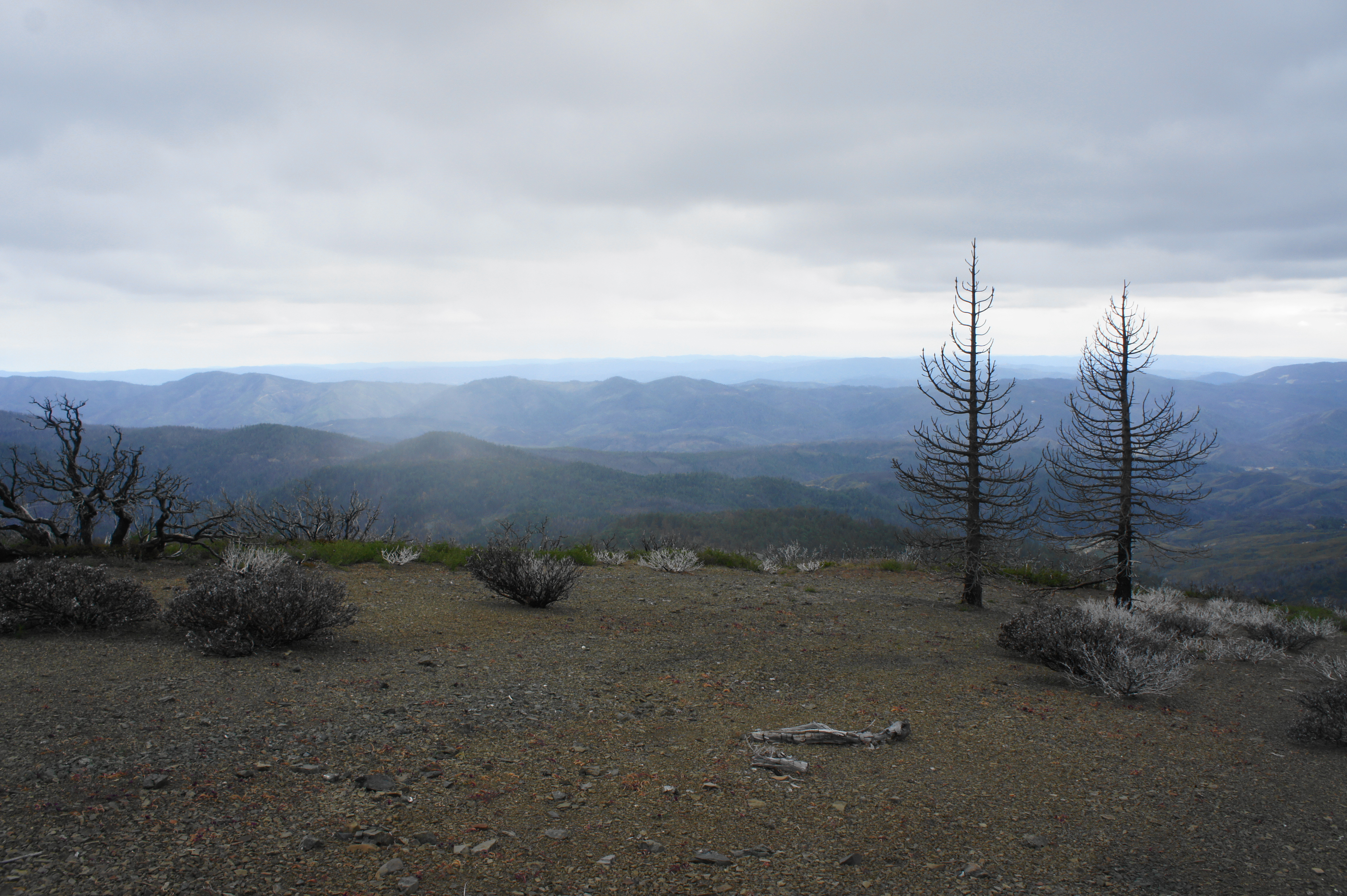
After flanking a rocky ridge, the path to the East Peak tackles a barren traverse, devoid of all but fine-grained, black-gray rock, offering views in both directions. Down to the left are Signal Peak (6,684’) and North Ridge (6,540’), still part of the Snow Mountain complex. To the right, one can see down the Dark Hollow Creek drainage toward Indian Valley. From here it is a steep and rocky but relatively brief ascent to the broad summit, which offers several nice places to sit and admire the panoramic vistas.
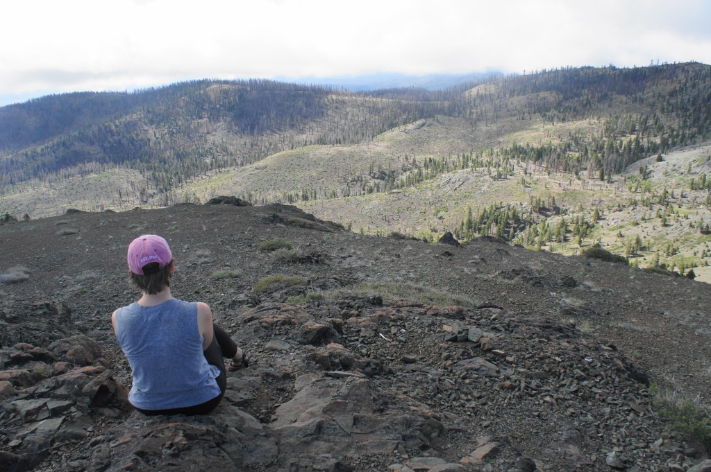
There’s plenty to see—at least if you’re lucky to have clear skies. To the east, the Mendocino Range gives way to the smaller Black Diamond Ridge, followed by Indian Valley and the Stonyford area. Beyond is the modest Clark Ridge and vast Central Valley, which spans all the way to the Cascades and Sierra Nevada on the eastern horizon. The body of water visible roughly due east is East Park Reservoir, a popular boating destination in Indian Valley.


The views to the south are largely blocked by the Snow Mountain behemoth, including the high West Peak, largely free of trees. To the north, the Mendocino Range continues for dozens of miles, through to the Yolly Bollys and Trinity Alps. Westward, a series of ranges and valleys extend all the way to the Pacific, although the ocean itself is just out of view. Down in Gravelly Valley, the sparkling blue waters denote another reservoir, this one called Lake Pillsbury, on the Eel River. (Note: From the West Peak, one can see south toward Mount Saint Helena and Mount Diablo, as well as Clear Lake.)
Snow Mountain East Peak to Cedar Camp via Milk Ranch Loop (4.4 mi.)
Once satisfied, return back down to the saddle to a four-way junction. Weary hikers can head back left, retracing your steps back to Cedar Camp. Those seeking to also bag West Peak can continue straight to reach the summit. But the adventurous who want to take an alternative, highly scenic route back to Cedar Camp should bear right, following the sign for “Milk Ranch.” This is the rest of the loop option.
From the ridge between the West and East Peaks, the narrow route drops steadily to North Creek Meadow, which hosts a small spring and thin stream. After crossing the brook, the trail becomes fainter, but one can generally discern the onward path as it skirts a rock outcrop on the right and reveals open views of Signal Peak to the north.

Hugging the hillside on the left, the trail gradually ascends a gravelly ridge, cresting it at about 3.05 miles (from Cedar Camp, including the East Peak spur). Now on the west side of the ridge, the trail slowly descends. Stay alert for a subtle bend in the trail at 3.35 miles; the trail switchbacks to the left and the pace of the descent quickens as it drops toward Milk Ranch Meadow. The beautiful meadow comes into view at about 3.6 miles; follow the slope (the faint path comes in and out here) down to the north flank of a sea of corn lilies. Here a clear route traverses a small but well-flowing stream, then climbs to the edge of the woods again, where another junction awaits.


Follow the sign indicating the Crooked Tree Trail, which bears left and skirts the west side of Milk Ranch Meadow. An abandoned outpost of some sort, complete with a small wood stove and large water tank, appears on the left. The trail around here is faint and difficult to follow; but as long as you follow the meadow on the left, you will find another trail marker again at 3.9 miles. (Note: The sign indicates “Bear Creek” and “Summit Springs” – the correct way!)
Leaving the pretty glen behind, the trail skirts a modest ravine on the left that bears Gully Spring, the ultimate water source for Milk Ranch Meadow. At about 4.1 miles, the route levels off and crosses another open glen; off to the right, one can see down Middle Fork Meadow, itself fed by a set of springs. Walk through the meadow, then pay close attention as the trail in the next stretch is easy to lose: after a short climb, the trail bears left across more modest flats.

At 4.35 miles, there is another leftward bend in the trail that is very subtle. Look for a patch of grasses/wildflowers; instead of continuing through the trees southward, the path bears eastward (left) through this patch. You are on the right track if you spot a small meadow on the left after about 150 yards from the subtle left turn. From here the track ascends to a woody pass at 4.5 miles.
Beyond the saddle, the Bear Creek drainage unfolds below. Although you are not likely to spot a flowing stream yet, a shady ravine begins to drop southward. Here the trail is again easy to lose: generally stay left, resisting the temptation to descend to the wash. The path hugs the hillside on the left and becomes considerably more discernable again as it tracks through an open patch of scrubby vegetation.
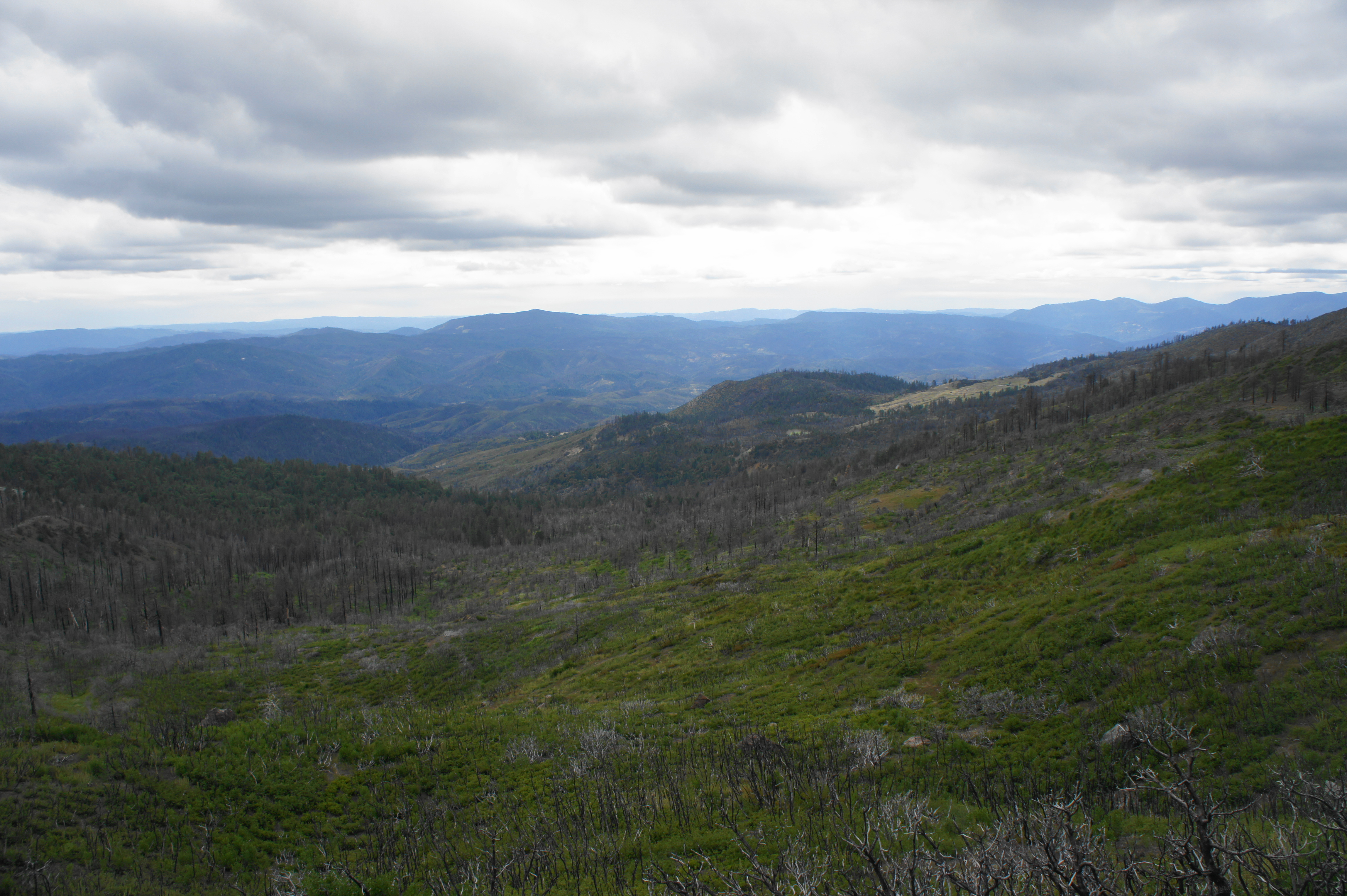
The woods beyond were heavily affected by the recent fires. But the sound of flowing water and lush undergrowth suggests the area is experiencing a slow regrowth. At 4.8 miles, the route passes Upper Bear Creek Springs on the right, continuing to skirt the Snow Mountain hillside. As the trail bears south, the bottom drops out of the Bear Creek drainage, creating a steep canyon sporting tall pines, many of which appeared to survive the fires. At 5.2 miles, the trail crosses a broader wash, with Lower Bear Creek Springs (the main source of Bear Creek) downstream to the right.
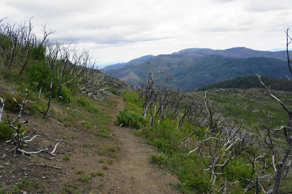
By now one has already spotted the onward route – a sudden and sharp ascent out of the shady drainage to a high pass. The ascent begins as a series of switchbacks, emerging out of the trees after 2/10 mile. While the views from the saddle at 5.7 miles are terrific, the scenery around is haunting: what once was a partly wooded slope has been reduced to ashes; scarcely a stump rises more than eight feet above the ground.


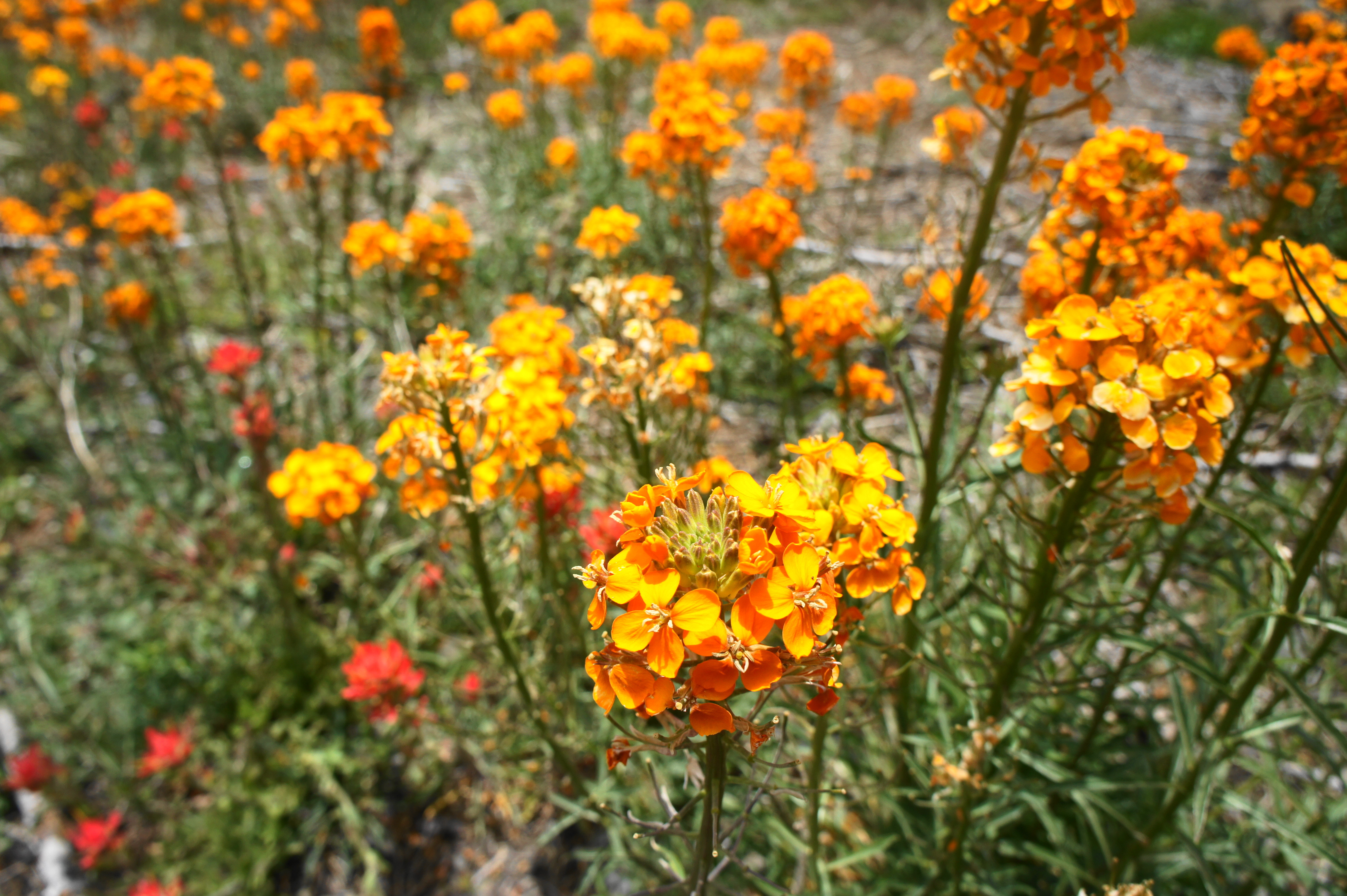
The terrain to the south looks just as eerie: an entire valley of tall conifers, virtually all reduced to skeletons. The saving grace as the trail descends into this forbidding landscape is the lush bloom of stunning orange wallflowers in late spring/early summer. As the Milk Ranch Loop Trail drops into the Grassy Spring area, the route becomes fainter but generally skirts the left side of a broad meadow of corn lilies. (Note: Route-finding in the opposite direction would be particularly challenging.) At 6.1 miles, most of the way around the loop, the trail skirts the drainage that leads down to Grassy Spring, then suddenly ascends again. (Note: There are some decent campsites and viewpoints across the wash to the south; these are possible alternatives to Cedar Camp.)
From here it is a short and mild walk back to Cedar Camp. Skirt around the west side of Cedar Pond, hop across a small stream, and then return to the Cedar Camp junction. This marks the end of the Snow Mountain/Milk Ranch circuit, which clocks in at about 6.6 miles.
Cedar Camp to Deafy Glade Trailhead (5.9 mi.)
If you camped at Cedar Camp the previous night, welcome back home! Hikers on a 3-day journey can call it a day here and spend another night. But those on a 2-day trek should pick up their belongings and prepare for the nearly six-mile return back to the trailhead. The route retraces one’s steps from the first day, although the 3,000-foot descent is largely preferred to the grueling uphill of the initial approach.


Do be careful, however, as one drops down Morale-Buster Hill and into the Stony Creek drainage. The 25-percent grade is steep and slippery, necessitating a slow and careful descent. After crossing Stony Creek again, a steep but short uphill turns into a mild ascent along the initial logging road. After 2-3 days and more than 18 miles of hiking, the Deafy Glade Trailhead is a welcome sight. Be sure to check out at the trail register.

All told, this strenuous but rewarding hike is best done as an overnight backpack, making it a possible weekend trip from Sacramento or Bay Area.
(Note: Wildflowers spotted on my mid-June 2020 hike: Indian paintbrush, mugwort, fringed Indian pink, lupine, pussypaws, scarlet larkspur, western wallflower, southwestern pricklypoppy.)

A beautiful writeup and photos of an area I’ve only seen from a distance. There’s an excellent support group for Berryessa-Snow Mountain National Monument, with this Facebook page: https://www.facebook.com/BerryessaSnowMountain/
Thanks for letting me know; I will definitely be following!
Between 1985 and 2000 I spent many days in snow mountain wilderness. Although I live in Idaho the biggest black bear I have ever seen was in bear wallow Creek.
Aside from the biggest black bear I’ve killed some nice bucks in that country as well. The turkey hunting was very rewarding as well. I love Idaho and I wouldn’t trade the hunting here for anywhere on Earth. However, I will always cherish my days afield with my old pard Bill Curtis he was a state trapper from the 50s through the late seventies and snow mountain held a special place in his life as well.
Pingback: Top 10 Hikes in 2020 | Live and Let Hike
Thanks for this informative report on a great trip. I’ll put this on the list. Are there any decent camping spots along Stony or Deafy Creek, say within a couple miles of the trailhead? Do you know if fishing is allowed in this area? Thanks!
Pingback: Phantom Falls Loop (North Table Mountain Ecological Reserve, CA) | Live and Let Hike