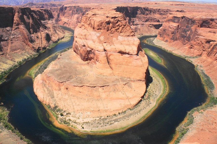

There once was a time when Horseshoe Bend—an entrenched meander along the Colorado River—was a relatively sleepy destination, known largely only to locals living in northern Arizona. But today, thanks to social media (and its high propensity for showing up as a Windows desktop background), the hairpin turn in Glen Canyon has become one of the most popular attractions in the Page, Arizona area. To be sure, Horseshoe Bend is a spectacular feat of geology in which the Colorado traces a 270-degree course through the ruddy sandstone. However, the Disneyland-like crowds and hefty parking fees ($10/vehicle) make this one of the most over-hyped destinations in the area. The newly-renovated trail to the Horseshoe Bend Overlook is wide, well-graded, and deemed ADA-accessible, but steady inclines could make wheelchair access difficult.
The hike
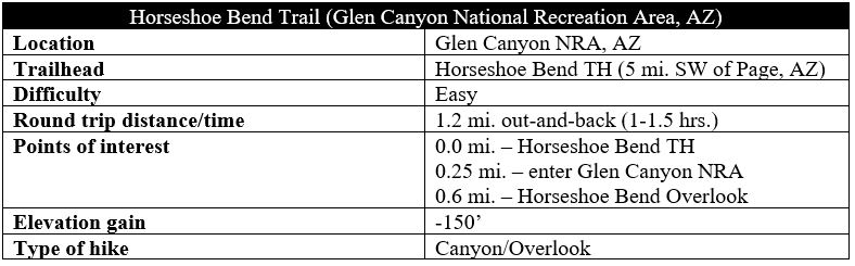
The Horseshoe Bend Trail in Glen Canyon National Recreation Area is situated about 1.6 miles down Highway 89 from its junction with Route 98, just southwest of Page, Arizona. The well-marked turnoff leads to an entrance station, where visitors must pay a $10 parking fee. The massive parking lot beyond often hosts dozens and dozens of tour buses and private vehicles.

There is now basically only one official trail leading from the parking area: the path to Horseshoe Bend skirts a modest hill on the left, with broad views across the scrubby escarpment north to Lake Powell and Page, with the Vermilion Cliffs off to the northwest. There is little shade on this highly sun-exposed trail, save for two man-made overhangs, the first of which is encountered on the right after 2/10 mile.

After clearing the initial hill, the route officially enters Glen Canyon NRA and then passes a second overhang at about 1/3 mile. From here the trail begins a steady and winding descent, wrapping down to the ever-popular overlook after about 6/10 mile of “hiking.”

While the main viewing area has a fence for protection, much of the surrounding rim is entirely exposed, with the vertical cliffs of the Navajo sandstone dropping precipitously to the Colorado River. Having encountered a particularly resistant chunk of the bedrock, the river here instead goes around it, forming the incised, or entrenched, meander visible today. Beyond Horseshoe Bend to the west, the flat plateau gives way to the higher cliffs of the Paria Canyon area and the Vermilion Cliffs, formed by older Jurassic period rocks.

After wrestling a place to snap a few photos at this scenic but immensely tourist-mobbed destination, return the way you came. All told, this short walk should occupy no more than 1-1.5 hours of your day, leaving plenty of time to explore some of the area’s more spectacular and lesser-visited hikes.
