

Rising to 3,304 feet, Chalone Peak is the highest point in California’s Pinnacles National Park and a worthy challenge for peak-baggers who seek to brave the exposed sun and 2,000 feet in elevation gain to reach the summit. The Chalone Peak Trail juts off from the end of Bear Gulch Cave in the eastern section of Pinnacles and climbs through a section of the park’s namesake spires and knobs before ascending a scrubby ridgeline to the windy highpoint. In terms of distance and elevation gain, this is probably the most difficult maintained hike in the park.
The hike
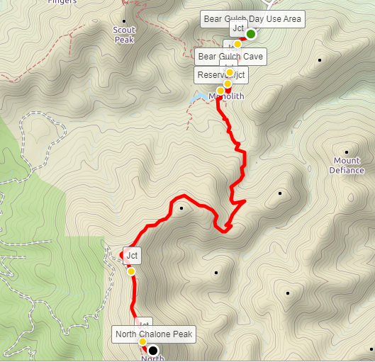
To reach the trail’s start, drive west along Pinnacles Highway from the Pinnacles Visitor Center in the eastern section of the park, continuing for 3.3 miles to the end of the road. Park at the Bear Gulch Day Use Area, which has a restroom and picnic tables. Tucked away in a shady canyon, Bear Gulch is a popular starting point for the short jaunt through Bear Gulch Cave, one of the area’s finest examples of a boulder-choked talus cave. (Note: For a full description of this shorter hike, see my post from January 13, 2020. To reach the trailhead, continue past the Bear Gulch Nature Center, which serves as the starting point for the excellent Condor Gulch-High Peaks Trail Loop. Parking is somewhat limited at the Bear Gulch Day Use Area; if there are no spots, backtrack to the Nature Center and park there, then follow an easy, wide path through a picnic area for ¼ mile to reach the trailhead.)
The approach to Chalone Peak begins by climbing the Moses Spring Trail from the parking area, traversing a shady oak woodland and entering a narrow gorge rimmed by rhyolitic breccia. Stay left at the first trail junction, then follow the path through a short, man-made tunnel. Take the left fork again at the next junction, turning onto the Bear Gulch Cave Trail. From here it is a short walk to the entrance of Lower Bear Gulch Cave, about 4/10 mile from the trailhead. (Note: Bring a flashlight for the cave, and check at the Visitor Center to ensure that the caves are accessible. Upper Bear Gulch Cave is generally open for only a short window in late March and late October and thus excluded from this description. The lower cave is usually open year-round except between mid-May and mid-July. If both caves are closed, use the Moses Springs Trail to bypass the cave to the west.)

Lower Bear Gulch Cave is dark and spooky, with vaunted ceilings formed by massive chockstones adorned with green lichen. After crossing the often-dry Bear Creek drainage, the trail climbs a long, winding staircase to bypass a series of dryfalls. After about 1/10 mile, the footpath leads through a narrow cut and reemerges into the sunlight above the cave. (Note: A spur near the end of the dark passage leads to Upper Bear Gulch Cave on the right but is closed most of the year.)
At the top of the cave, bear left at the subsequent trail junction, staying on the Bear Gulch Cave Trail. From here the path ascends a scrubby hillside, then follows the boulder-choked canyon to a second, shorter cave at 6/10 mile. The chockstones in this dark passage, wedged between the canyon walls, are enormous and nearly touch the floor, requiring hikers to duck their heads as they pass.


Emerging out of the cave, hikers ascend a narrow staircase to reach the Bear Gulch Reservoir, a man-made lake that is nonetheless scintillating in its calmness amid a setting of towering stones. This is a popular lunch spot and turn-around point for day hikers.

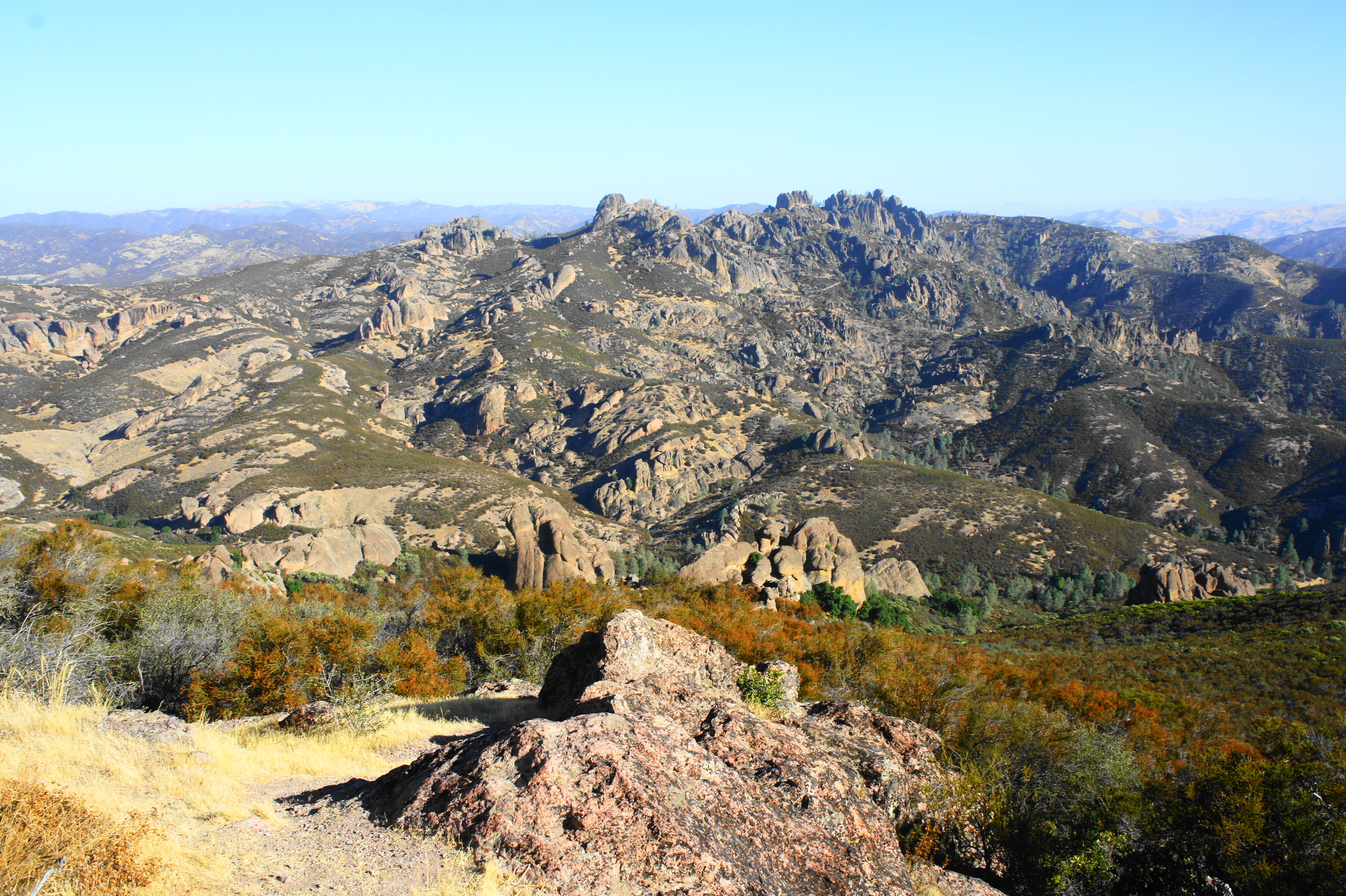
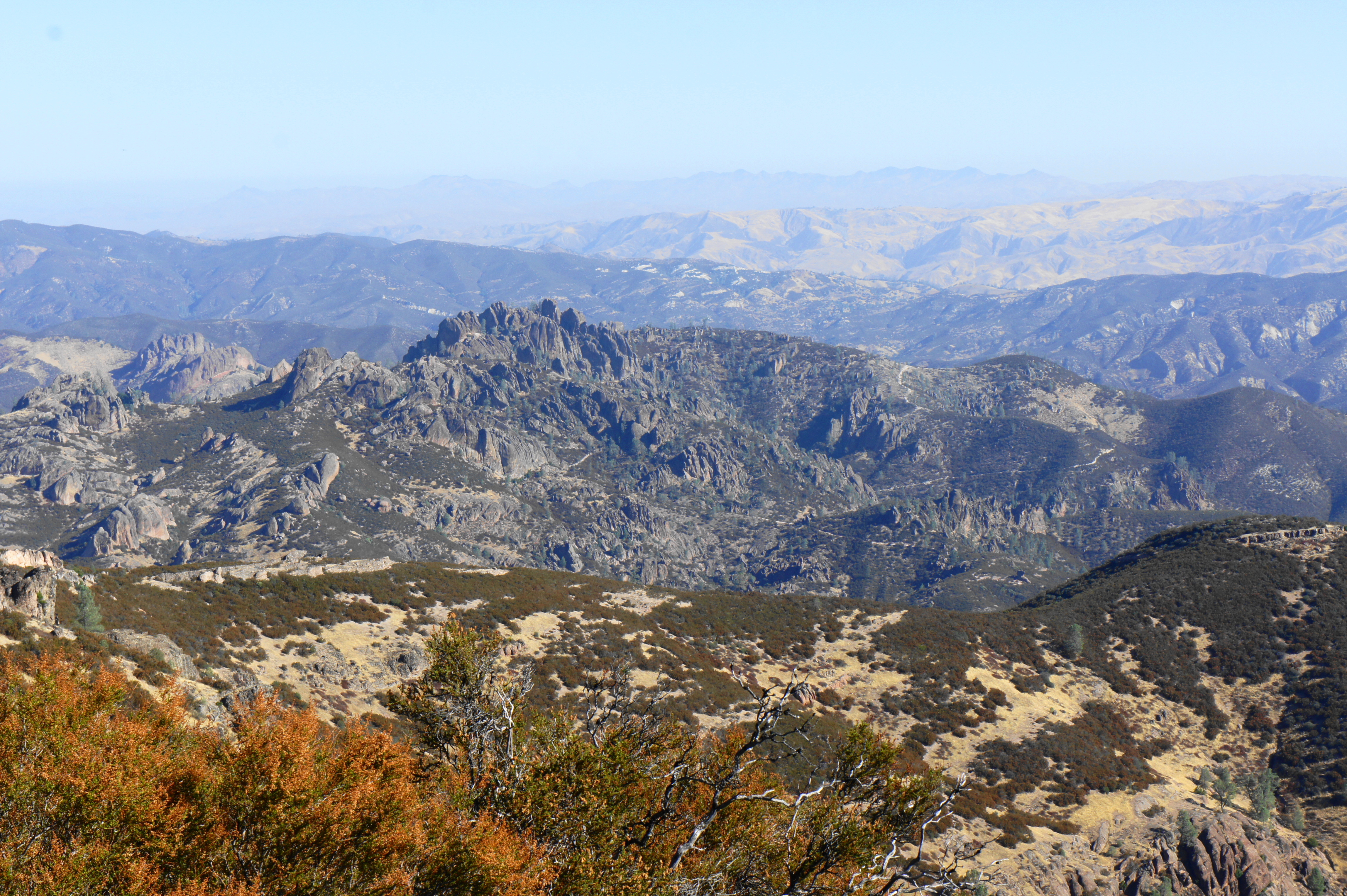
Having cleared the cave section, bear left at the reservoir at the start of the Chalone Peak Trail, which hugs the lake’s eastern shoreline. Pass a spur to “The Sisters” climbing area on the left, staying on the main track as it bears southward. Around ¾ mile from the trailhead, the trail cuts left and leaves the reservoir behind, beginning a steady ascent through a side canyon in an area known as the Little Pinnacles. As you gain height, look back to the north for distant views of the High Peaks, the towering heart of Pinnacles National Park.
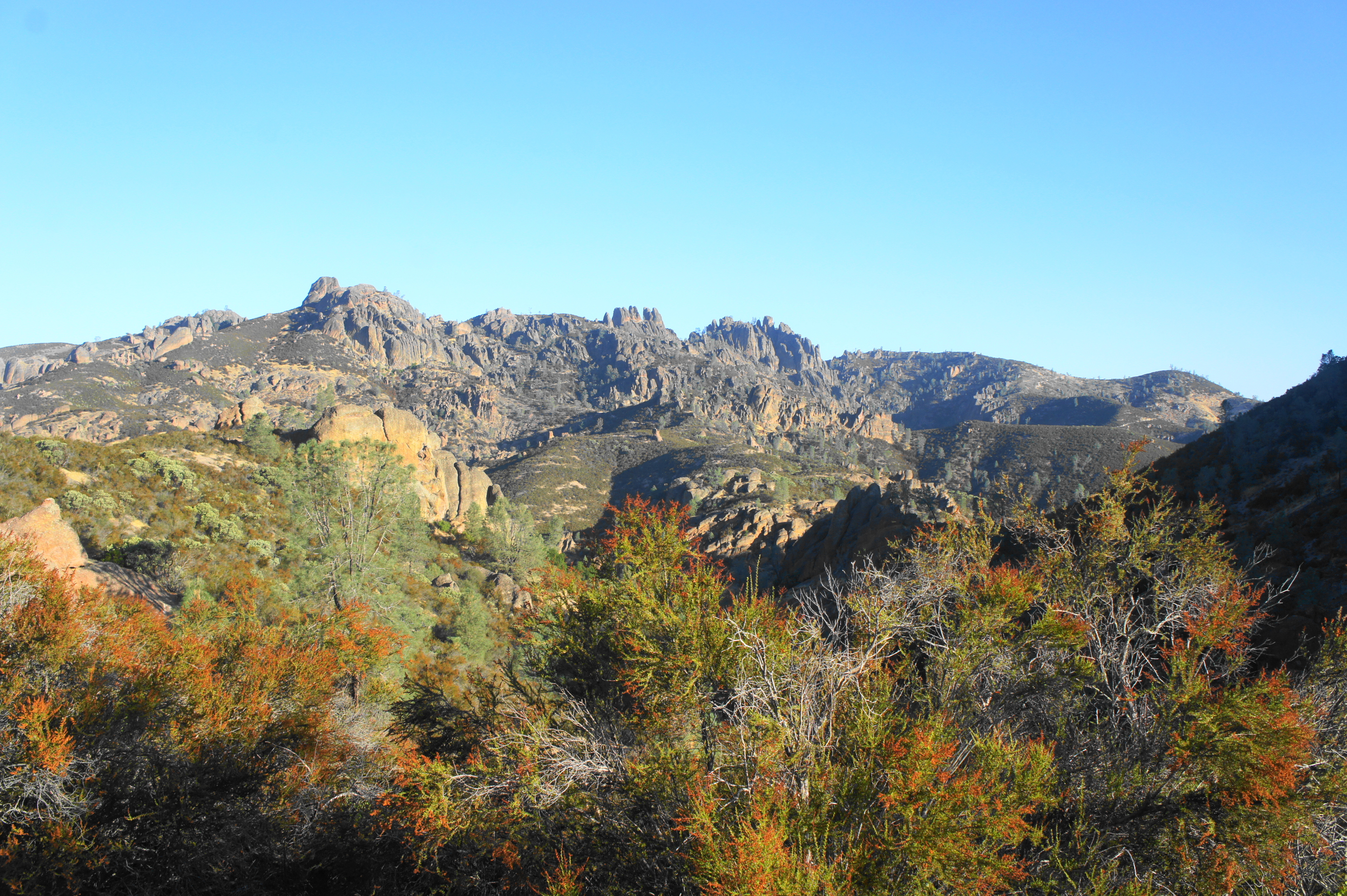
Although not particularly steep, the ever-climbing trail gains 200 feet in elevation before cresting a ridgeline at 1.25 miles. One can now see down Frog Canyon to the east, flanked by the imposing Mount Defiance (2,657’) beyond. While not as ubiquitous as in the High Peaks, the rhyolitic pinnacles on the right are impressive in their own right. Even better, the crowds are likely to be minimal, leaving one virtually alone in the rock-strewn wilderness.

Beyond the ridgeline, the Chalone Peak Trail ascends again, hugging the western slopes of Frog Canyon. After a set of switchbacks, hikers encounter sporadic manzanitas, sporting lime green leaves and deep red bark. Overtaking another ridgeline at about the two-mile mark, hikers get their first views of Chalone Peak in the distance. The plant life here is all scrubby chaparral, with the predominant shrub being the ubiquitous chamise.
From the saddle at the top of Frog Canyon, the trail continues right, beginning a long and arduous climb up the northern rib of the Chalone Peak behemoth. The north-facing hillside offers tremendous views of the Pinnacles region, including Bear Gulch and the High Peaks. At 2.5 miles, a rock outcrop provides perhaps the best viewpoint of the entire hike (because the Pinnacles are more distant from the summit of Chalone Peak).
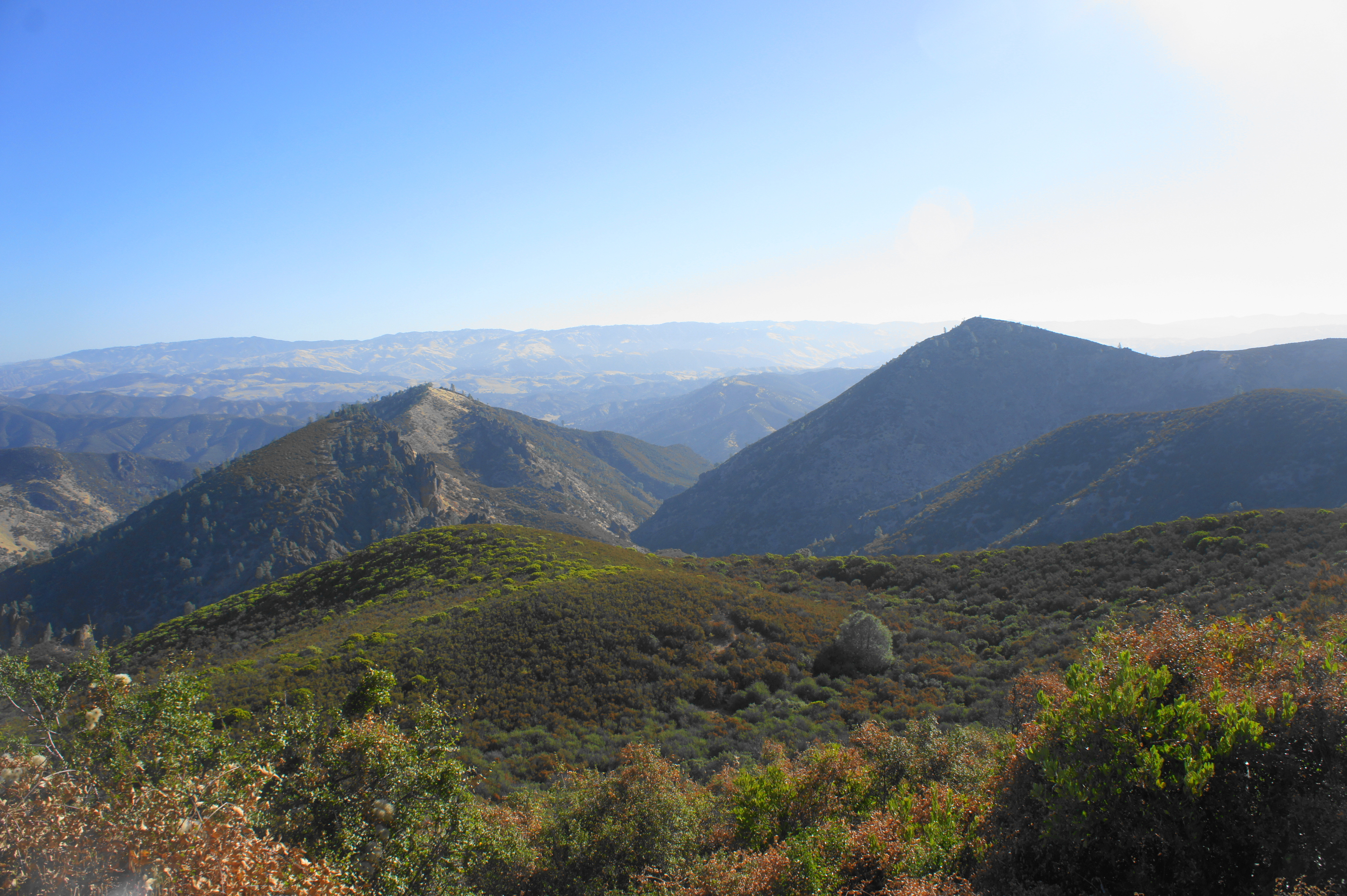
As the trail bends south, take in westward views over Salinas Valley to the Santa Lucia Range beyond. Down in this valley is the town of Soledad, the gateway to the western reaches of Pinnacles National Park.
A little over three miles into the hike, the trail reaches a cattle fence, with a wooden stile providing onward passage. Follow the fence on the left as the trail continues to climb. At 3.2 miles, the Chalone Peak Trail merges with a wide gravel road. Continue left, following the broad track as it approaches the peak to the south. By now you have gained more than 1,500 feet in elevation.


After a brief descent to a high saddle, the ascent picks up again, following the west-facing flank of North Chalone Peak. This is the steepest part of the hike and often in the sun. At 3.7 miles, pass through a metal gate, passing the easy-to-miss spur to South Chalone Peak (2,269’) on the right. (Note: Technically this hike describes a climb to North Chalone Peak, the highest of the two. But it is possible to continue from here on an unmaintained path to South Chalone Peak.) Just beyond, the road passes under a string of power lines.

Finally, at 3.8 miles, the path rounds a left-hand bend, and the abandoned tower atop Chalone Peak appears ahead. Follow the road as it winds around to the top, just under four miles from the trailhead.


While the tower itself is closed to visitors, circling the summit provides panoramic views of the region. To the north, one can peer over the Pinnacles region, with the Gabilan Range continuing beyond. The Coast Range sprawls eastward toward the Central Valley, with Mount Defiance in the foreground to the northeast.


The southward view is dominated by South Chalone Peak, a summit accessible to hikers by way of an additional 1.6-mile one-way track. To the west, one can see across Salinas Valley to Soledad and the Santa Lucia Range, with the Pacific Ocean obscured behind the high mountains. In short, North Chalone Peak, the third-highest mountain in the Gabilan Range, is one of the best viewpoints in the region.


The drawback, of course, is the looming reality of a 4-mile hike back the way you came to return to the trailhead. Yet the downhill slope is considerably more pleasant than the earlier ascent, and shifting light offers different perspectives of the pinnacles, peaks, and canyons along the way. Once back at the Bear Gulch Reservoir, there are a few options to return to the Bear Gulch Day Use Area: the first is to return down Bear Gulch Cave, the second is to follow the cave trail part way down and then turn on the Moses Spring Trail, and the third is to follow the scenic Rim Trail along the western slopes before descending the High Peaks Trail back to the start.
If taking the shortest route (through the caves), the entire round-trip hike clocks in at about 7.8 miles, a half-to-full day of hiking for many. Allot at least four hours for the out-and-back; all but the heartiest hikers will probably need at least five or six.

Pingback: Top 10 Hikes in 2019 | Live and Let Hike
Pingback: Top 10 Hikes in 2020 | Live and Let Hike