Echo Park Road

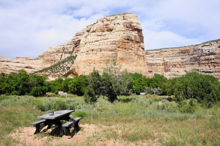
Steamboat Rock, Dinosaur National Monument, June 2022 Roughly straddling the border between Utah and Colorado, Echo Park Road extends 12 miles and connects the paved Harpers Corner Road with its namesake Echo Park—a hidden flat near the confluence of the Green and Yampa Rivers in Dinosaur National Monument. Here travelers will find a campground and …

Continue reading Echo Park Road

Jones Hole Trail & Ely Creek Falls (Dinosaur National Monument, UT)

Jones Hole Trail, Dinosaur National Monument, June 2022 Although most famous for its prehistoric fossils, Dinosaur National Monument in northeast Utah and northwest Colorado covers more than 200,000 acres of canyon country that rivals the “Mighty Five” national parks farther south. Here the Green and Yampa Rivers—and their various tributaries—have carved a labyrinth of snaking …

Continue reading Jones Hole Trail & Ely Creek Falls (Dinosaur National Monument, UT)

Grimes Point Petroglyph Trail (Grimes Point Archaeological Area, NV)

Grimes Point Petroglyph Trail, Grimes Point Archaeological Area, September 2020 For travelers driving Nevada’s Highway 50—the “Loneliest Road in America”—Grimes Point is an excellent spot to get out and stretch your legs, taking advantage of a short trail to a fantastic set of ancient petroglyphs. Undoubtedly more vivid and more interesting than Hickison Petroglyphs, which …

Continue reading Grimes Point Petroglyph Trail (Grimes Point Archaeological Area, NV)

Hickison Petroglyphs Interpretive Trail (Hickison Petroglyphs Recreation Area)

Hickison Petroglyphs Interpretive Trail, Hickison Petroglyphs Recreation Area, September 2020 Highway 50, which stretches for more than 400 miles across central Nevada, is called the “Loneliest Road in America” for a reason. Services and cell service are in limited supply as travelers skirt the desolate mountain ranges and sagebrush-studded valleys of the Great Basin region. …

Continue reading Hickison Petroglyphs Interpretive Trail (Hickison Petroglyphs Recreation Area)

Rings Loop Trail (Mojave National Preserve, CA)

The Rings Loop Trail at Mojave National Preserve’s Hole-in-the-Wall area meanders through Banshee Canyon, a wild, narrow notch named by early settlers for its howling desert winds. Though only 1.4 miles, this brief circuit packs a punch, passing through desert scrub to a set of ancient petroglyphs before ascending a pair of ring ladders, bolted …

Continue reading Rings Loop Trail (Mojave National Preserve, CA)

Utah Highway 279 from Moab

Moab, Utah—the now iconic hangout for hikers, bikers, climbers, and alas, jeep enthusiasts—is situated amid a sea of slickrock and flanked by the Colorado River, the blissful sculptor of many of the American Southwest’s grandest canyons. While millions flock to Moab’s Arches or Canyonlands National Parks each year, lesser-known Highway 279 follows one of the …

Continue reading Utah Highway 279 from Moab

Capitol Gorge Trail, including the Tanks (Capitol Reef National Park, UT)

The mostly level and shady Capitol Gorge Trail continues up the narrow canyon where the scenic Capitol Gorge Road ends. A geological cousin of nearby Grand Wash, Capitol Gorge also played a central role in the area’s human history. For nearly 80 years, despite its extreme narrows, the canyon was the only reliable transit point …

Continue reading Capitol Gorge Trail, including the Tanks (Capitol Reef National Park, UT)

Secrets of Capitol Reef National Park

In many ways, Capitol Reef National Park is Utah’s best-kept secret. Despite its central location—roughly halfway between tourist behemoths Arches National Park and Bryce Canyon National Park—Capitol Reef packs as great as a punch as its more popular neighbors with far smaller crowds. Even the park’s most travelled areas—the Highway 24 corridor and Scenic Drive—offer …

Continue reading Secrets of Capitol Reef National Park

Utah Highway 211 to Canyonlands National Park’s Needles District

Canyonlands National Park’s Needles District comprises more than a hundred square miles of spindly spires, dizzying canyons, and colossal views. It also boasts some of Utah’s best hiking and backpacking opportunities, including the Chesler Park Trail, the Big Spring – Squaw Canyon Loop, and the Confluence Overlook Trail. Yet visitors making the 1 ½-hour drive …

Continue reading Utah Highway 211 to Canyonlands National Park’s Needles District

Natural Bridges Loop Trail, including Mesa Trail (Natural Bridges National Monument, UT)

The principal wonder of Natural Bridges National Monument in southeast Utah is this: nowhere else in North America—perhaps the world—can you see three of Earth’s largest natural bridges in one day’s hike. Yes, that’s natural bridges, not arches, mind you—the former are carved by continuously-flowing streams, while the latter rely on the erosional forces of …

Continue reading Natural Bridges Loop Trail, including Mesa Trail (Natural Bridges National Monument, UT)