

Some places have great stories, and popular hiking destination Cohab Canyon in Utah’s Capitol Reef National Park is exactly one of those places. For the Mormon faith’s remaining polygamists in Utah, the late 1800s were a trying time: the state had just consented to the Edmunds Act, which bans the practice. Federal law enforcement officials were intermittently sent to the state’s most remote corners, including the tiny town of Fruita, to stamp out plural marriage. As legend has it, Fruita’s polygamists evaded suspicion by hiding their many wives in a nearby canyon—hence the name of today: Cohab (for “cohabitation”) Canyon.
Beginning just over a mile from the Capitol Reef Visitor Center, the 1.7-mile hike (one-way) through Cohab Canyon is one of the park’s most popular. Whether or not the legend is true (there are many unbelievers), it is hard not to let your imagination run wild amid Cohab Canyon’s speckled walls, towering fins, and thin slots. A colorful hoodoo and hidden natural arch add to the allure, and a pair of spur trails climb to excellent overlooks of the Fremont River and Fruita historic area.
The hike
The best way to hike Cohab Canyon, if possible, is one-way with a shuttle pick-up. There is a loop option—beginning at the Hickman Bridge Trailhead, climb through Cohab Canyon to the Frying Pan Trail, then swing around via Grand Wash—but at 10.5 miles (including two miles of road-walking), this is a lengthy haul. A decent 1-2 hour option is to hike 1.1 miles from the Cohab Canyon Trailhead (off the Scenic Drive), turn left to visit the overlooks, then return the way you came; this is a 3.4-mile round-trip. Those who complete the entire round-trip route from end to end, plus the overlooks, are looking at a 4.6-mile, 2.5- to 4-hour hike.
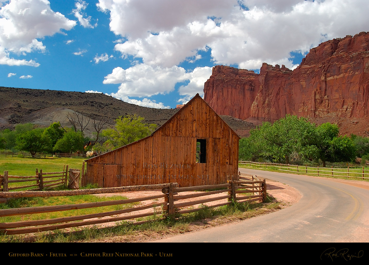
The Cohab Canyon Trailhead is situated 1.2 miles down the Scenic Drive from the Capitol Reef Visitor Center. At the sight of the old Pendleton Barn, look for a small parking area on the left. There is sufficient parking here for 4-5 cars; if full, backtrack 2/10 mile and park at the picnic area. Those staying at the Fruita Campground can simply cross the street and bear slightly north to catch the trail.
From the parking area opposite the historic barn, hikers must walk south along the Scenic Drive for 20 yards or so to reach the well-marked trailhead.
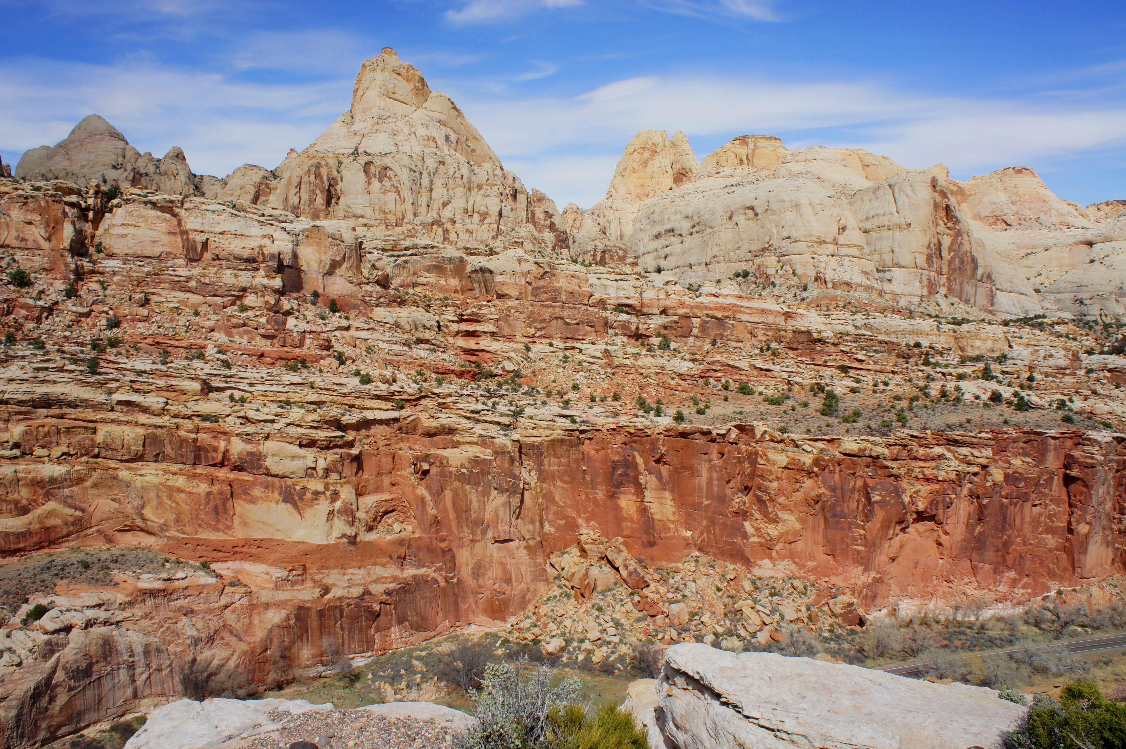
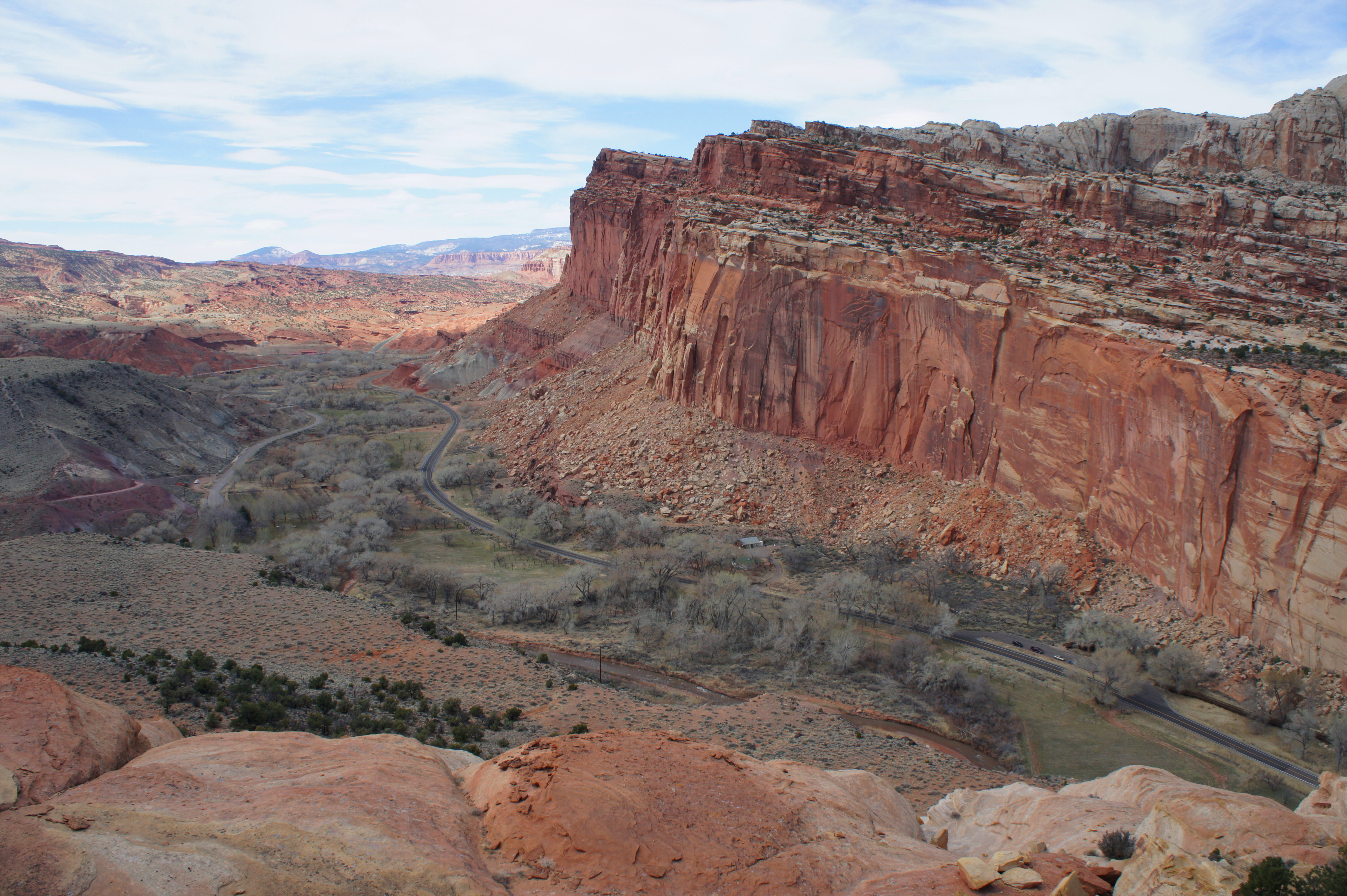
The Cohab Canyon Trailhead sits at the base of a pastel-colored Chinle slope composed partially of soft bentonite clay. Above the three visible “members” of the Chinle is the mighty Wingate sandstone—near-vertical cliffs, rich in iron, flaunting a remarkable orange hue—into which much of Cohab Canyon is carved. To reach the Wingate first requires surmounting a set of exactly 22 switchbacks, an ascent that covers 400 feet in elevation gain over the course of 1/4 mile. Breaks are in order—not only to catch your breath, but to enjoy the spectacular views back west, where the Fruita historic area, Johnson Mesa, and the stunning Fruita Cliffs unfurl below. To the southwest, the Fremont River cuts sharply into the Moenkopi layer, forming a deep gorge.

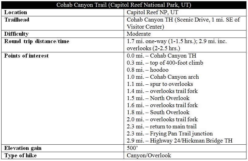
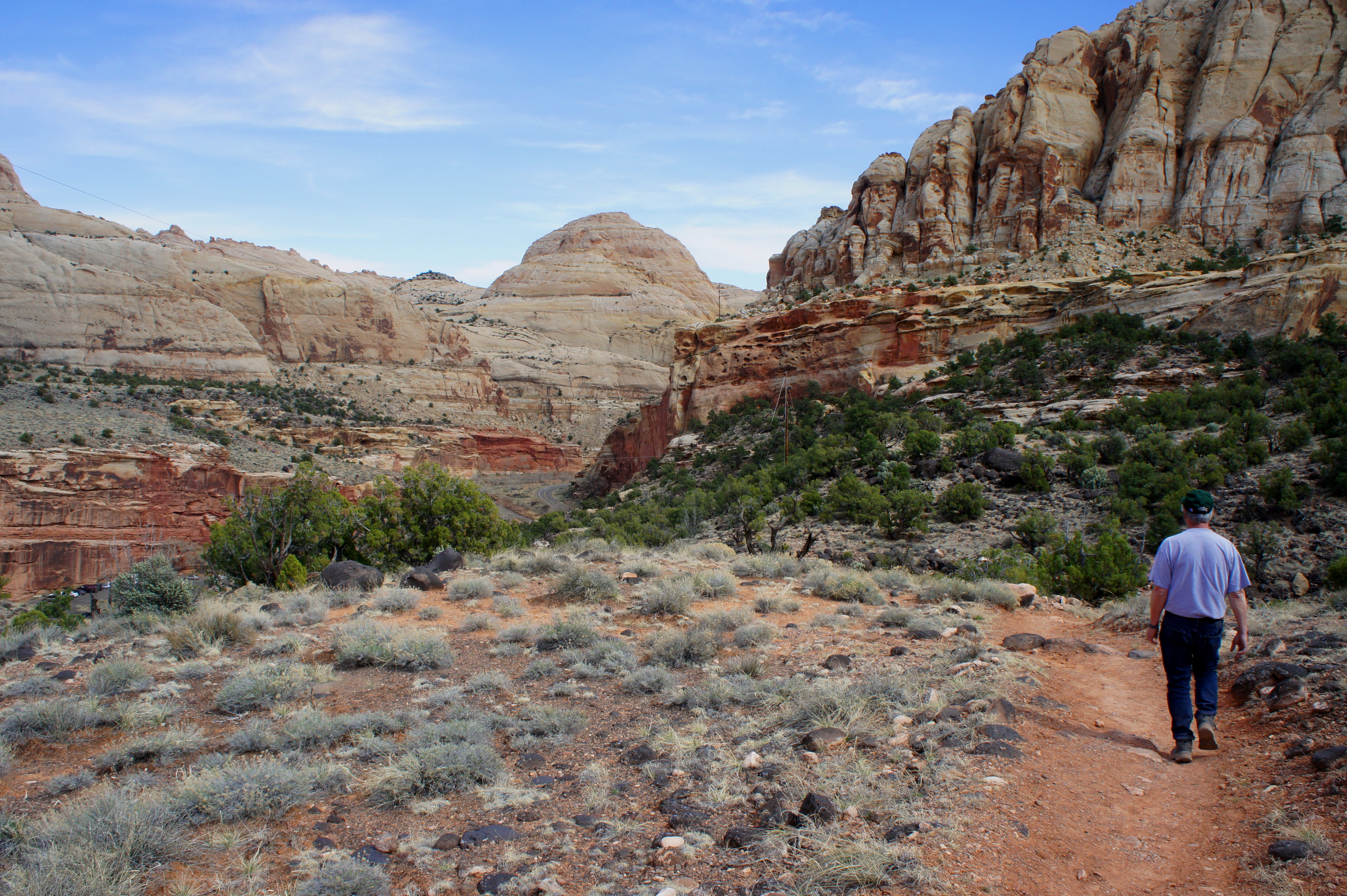
Following the switchbacks, the trail flattens out and edges south, reaching the mouth of Cohab Canyon after 1/3 mile of hiking. Cohab Canyon, formed from vertical jointing in the Wingate, is an example of a “hanging canyon,” as it sits high above the Fremont River floodplain. An aerial view reveals a narrow gorge that slices east-west through a series of north-south running cuts. (Note: in keeping with tradition, the north-south slots navigable by canyoneers are widely known as “the Wives.”)
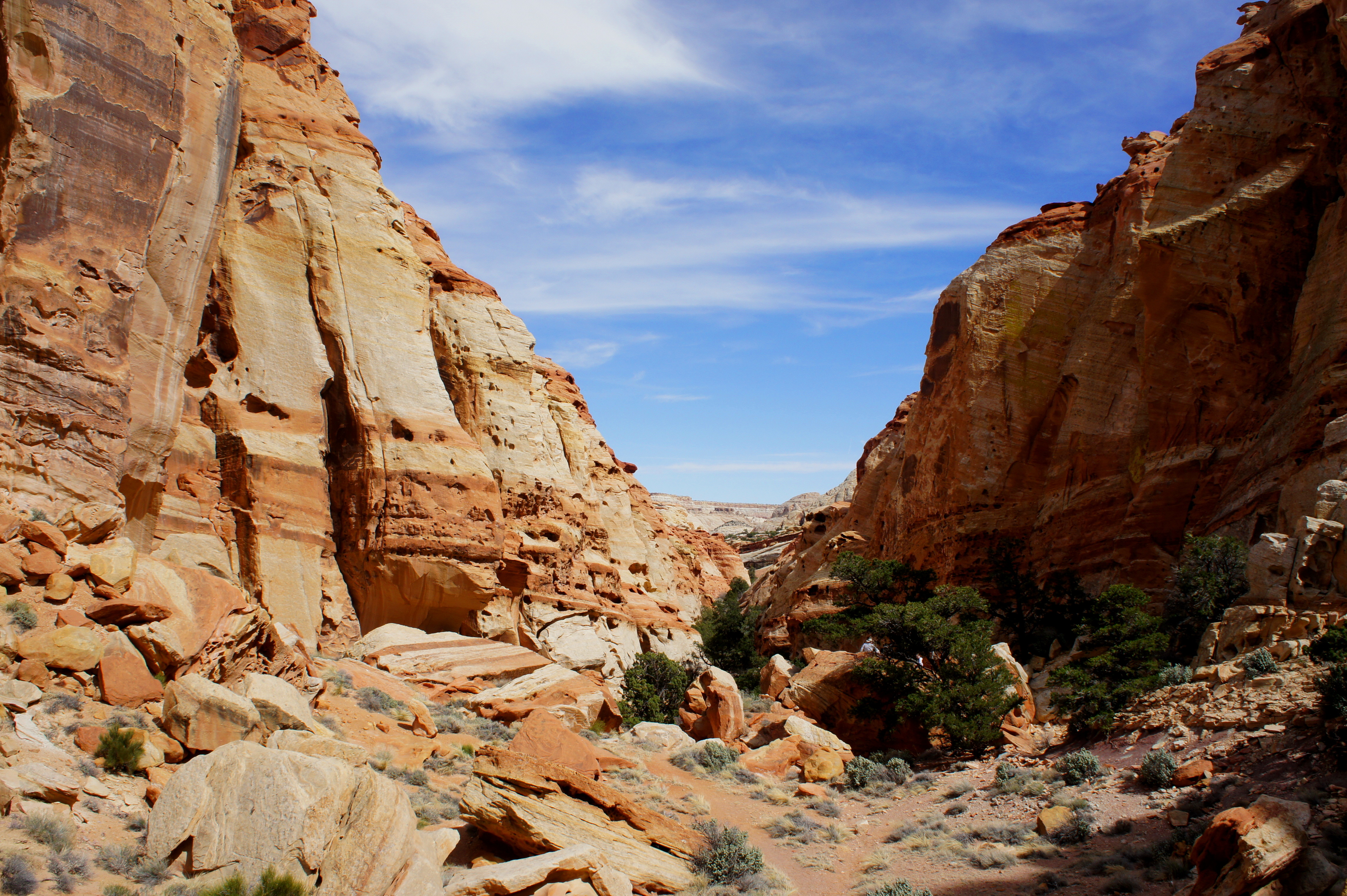
Perhaps the most striking feature of this landscape of striped fins is the thousands upon thousands of Swiss cheese-like holes in the Wingate walls. These “solution pockets” or “tafoni” are not the handiwork of burrowing animals; rather, they were formed through the dissolution of fine sand grains once glued together by calcium carbonate. With exposure to the elements—namely water—these fragile bonds break, leaving a sponge-like system of tafoni. Walking amidst the “beehives” of Cohab Canyon can feel like an otherworldly experience.
Leaving the splendid views of Fruita behind, the trail plunges into Cohab Canyon, staying first to the right side, then simply follows the sandy wash bottom. For a ¼-mile section, the trail disappears into the arroyo; simply walk in the wash bed until signage indicates otherwise. Vegetation becomes more prevalent, and the canyon gradually widens. It is worth exploring one or two of the side canyons on the right (the “Wives”); one boasts a dramatic, curved chamber, while another comprises a skinny, 50-yard slot ending at an impassable dryfall. It’s fun to imagine a gaggle of Mormon wives gathering in one of these spots, on the run from the authorities.

The Wingate withers away in the lead-up to a minor pouroff in the Kayenta formation, a slightly younger sedimentary rock layer dating to the early Jurassic Period. The Kayenta is a multicolored tier of ledges and benches; the highlight of the Kayenta section in Cohab Canyon is a 20-foot mushroom-shaped hoodoo surrounded by slickrock.

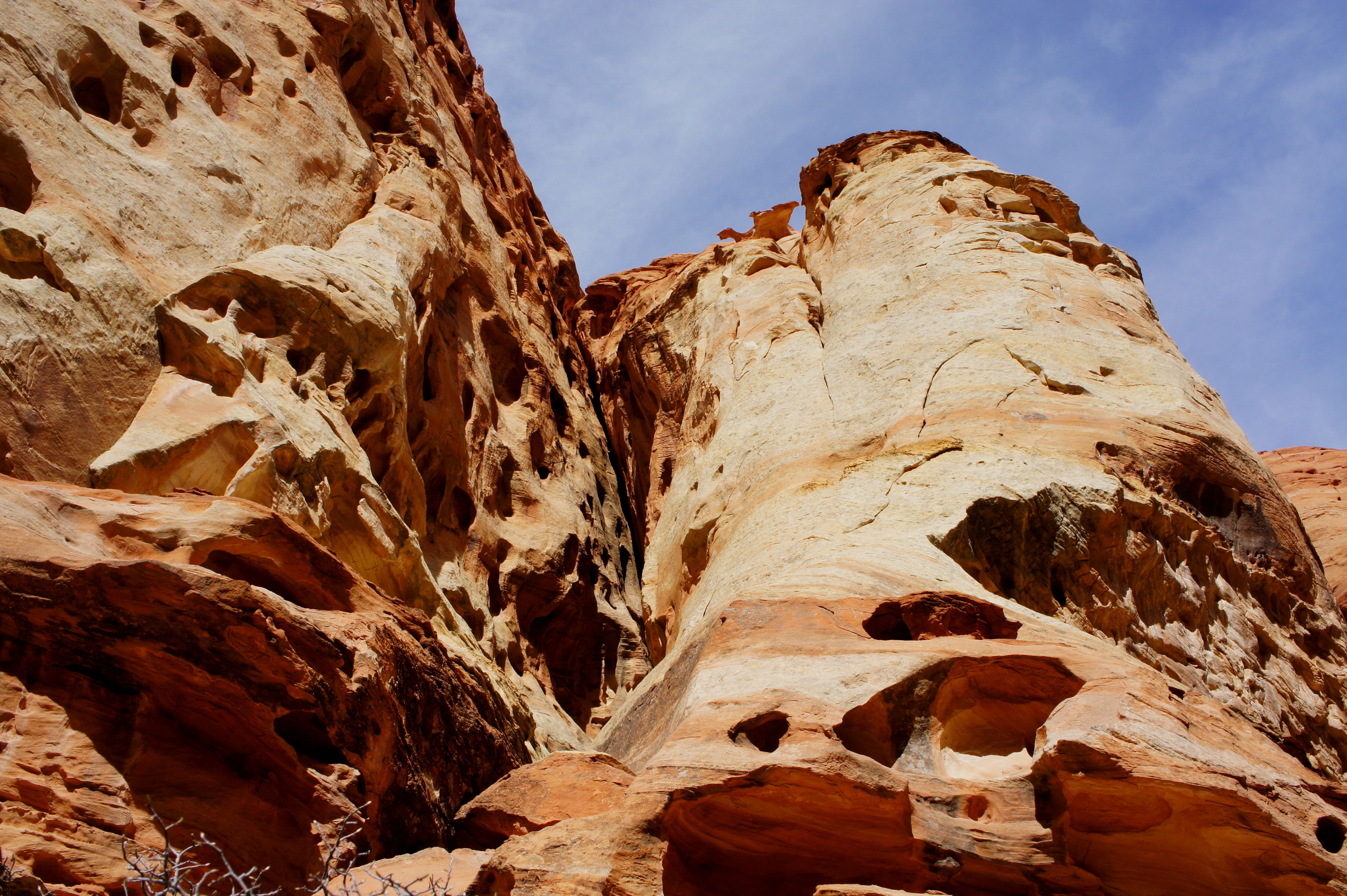
From the mushroom, it is a short walk back to the wash bottom (look for the small Cohab Canyon Arch, a hollowed pothole, along the right-hand wall) and to the first trail junction. This is the start of the spur to the Fruita Overlooks.
The diversion to the overlooks is a worthy endeavor for its bird’s eye views of Cohab Canyon, the Fremont River, and Fruita. The first 1/3 mile involves steep switchbacking up to the top of a flat strath terrace, at which point the trail forks. A right turn leads in 1/10 mile to the North Overlook, which offers fine vistas of the Fremont River Canyon, Walker Peak, and the sea of cream-colored Navajo sandstone across Highway 24.
A right turn back at the junction leads in about ¼ mile to the South Overlook, which is similar to the view from atop the hike’s initial switchbacks.
Returning to the main trail, follow Cohab Canyon southeast as it continues cutting through the Kayenta. Less than a minute from the start of the overlook spur, the trail climbs partway up the southern bank to the Frying Pan Trail junction. This magnificent, 3-mile trail connects Cohab Canyon with the Cassidy Arch and Grand Wash Trails.
The final 6/10 mile down to Highway 24 and the Hickman Bridge Trailhead comprises several fine views of the Fremont River Canyon, as well as the iconic Capitol Dome. The descent is gradual, steepening only in a couple of places near the end, after passing under a string of telephone lines. The trail spits out at Highway 24 slightly east of the Hickman Bridge Trailhead; cross the road and walk a short distance west to reach the parking area. If no vehicle pick-up awaits, return the way you came—climbing gradually back into Cohab Canyon, then dropping steeply down the switchbacks to Fruita.

Cohab canyon is magnificent! We were luck to have it to ourselves so we could gawk at all the features along the way. The overwhleming number of solution pockets made this extra exciting. We enjoyed checking out the few little side slots along the way. Super views from the overlook! Great photos and description, Andrew!
We had such a good time in Utah, and your trail guides are the best! Capitol Reef is amazing, and not nearly as crowded.
Pingback: Top 10 Hikes in Capitol Reef National Park’s “Frontcountry” | Live and Let Hike
Hi! We would like take the shuttle near the Hickman Bridge TH (as you suggest) to come back to Fruita campground after doing Cohab Canyon Trail, but I can’t find any information about a shuttle in Capitol Reef… we are in Capitol Reef Friday 7th Sept. Thanks for the help!
Hi there – my apologies for being unclear in the post. There is not a shuttle – I meant if you had a car with someone sitting out the hike would could pick you up on the other hand. Unfortunately you would have to do an out-and-back (or walk along the road to form a loop) without a pickup.
Hi Andrew, thanks for your answer! Perfect, now it’s all clear. Thank you very much again!
Pingback: Return to Capitol Reef National Park | Live and Let Hike
Again, Andrew, your assessment of the best hike rang true for us. What an incredible hike and our favorite in the north part of the park. My husband and I climbed this in Oct 2020 with winds howling along the initial steep climb and got especially fierce at the canyon opening, lessening as you hiked the canyon itself. Beauty abounded! Wow. Loved the little side slots and how up close all the beauty of the canyon walls were. We took the side hike, as recommended, to the north overlook – which was another great vista point.
Pingback: Utah Mighty 5 Road Trip Guide - Seacliff Creative
Pingback: Utah Mighty 5 Road Trip Guide | Moutamadriss
Pingback: The Good 10-Day Utah Nationwide Parks Street Journey Itinerary: Utah Mighty 5 Street Journey Information - Brand Rator
Pingback: Utah Mighty 5 Road Trip Guide | Sky Pacific Trip
Pingback: Utah Mighty 5 Road Trip Guide | Travel Experientia
Pingback: Utah Mighty 5 Road Trip Guide | Get Travel Cheaper
Pingback: Utah Mighty 5 Road Trip Guide | Voyage Veritas
Pingback: Utah Mighty 5 Road Trip Guide | Drop Align
Pingback: Utah Mighty 5 Road Trip Guide | Trip Wherever
Pingback: Utah Mighty 5 Road Trip Guide | Safari World Travel
Pingback: Utah Mighty 5 Road Trip Guide | Rileys Travel
Pingback: Utah Mighty 5 Road Trip Guide | Ticket Bucks
Pingback: Utah Mighty 5 Road Trip Guide - Travel Savings
Pingback: Utah Mighty 5 Road Trip Guide | travel zzy
Pingback: Utah Mighty 5 Road Trip Guide | Travels Budget
Pingback: The Perfect 10-Day Utah National Parks Road Trip Itinerary: Utah Mighty 5 Road Trip Guide - Newsbuddy
Pingback: Utah Mighty 5 Road Trip Guide | Travel Introduction