

After spending four months as a seasonal interpretive volunteer at Capitol Reef National Park, I have completed a whopping 46 blog posts for Live and Let Hike about Capitol Reef, including 42 detailed descriptions of the park’s trails and routes. Alas, despite wishful thinking, your average visitor to Capitol Reef is not likely to research dozens of hikes before arriving. Most come unprepared, asking at the Visitor Center: “So…which one is the best?”
The answer is inherently subjective, especially in a park encompassing 378 miles of diverse terrain. Furthermore, hiking experiences are inevitably colored by a number of variables, including weather, crowds, difficulty, group size, pace, and the general temperament of the hiker. Wildlife sightings add to the appeal. Stubbed toes? The opposite.
Caveats aside, the following is my valiant effort to make sense of the morass: a completely subjective (but at least well-researched?) list of the top ten hikes in Capitol Reef’s frontcountry. By this I mean the park’s 15 maintained trails in the central Fremont River District—along Utah Highway 24 and the Scenic Drive—plus a handful of nearby short but unmaintained routes (e.g., The Castle Trail, Pleasant Creek). The backcountry—including Spring Canyon, Cathedral Valley, and the southern Waterpocket District—is another beast and is covered in a second “top ten” list.
For now, consider this your homework: a top-ten guide to trails and routes in Capitol Reef’s frontcountry. (Note: See also, “Top 10 Hikes in Capitol Reef National Park’s ‘Backcountry’,” or, for a complete list of hikes, check out the Capitol Reef Hiking Guide.)

- Fremont River Trail (Easy to Moderate; 2.6 mi. out-and-back, 1.5-2 hrs.)
Capitol Reef’s Fremont River Trail begins in the historic town of Fruita amid drooping cottonwoods, neatly cultivated orchards, and the perennial stream for which the hike is named. The first 4/10 mile are flat, easy, and wheelchair-accessible, but the trail beyond takes on a different flavor as it climbs steadily out of Fremont Gorge and terminates atop a windswept hill. From this viewpoint, the immense and colorful Waterpocket Fold, a 100-mile long wrinkle in the Earth’s crust, unfolds to the east.
See my post on February 26, 2015 for a full trail description.

- Capitol Gorge Trail + the Tanks (Easy to Moderate; 2.2-5.4 mi. out-and-back, 1.5-4 hrs.)
Arguably not as spectacular as its nearby cousin (see #5 below), Capitol Gorge is nonetheless a narrow canyon with an important role in the area’s history. Constructed in 1883, the “Blue Dugway” provided passage for wagons—and eventually automobiles—through Capitol Gorge and served as the only road across the 100-mile long Waterpocket Fold for almost 80 years. Now open only to hikers, the narrowest reaches of Capitol Gorge still bear remnants of the pioneers who passed through a century ago, including a myriad of inscriptions and old telephone lines. Many hikers turn around at the Tanks, a series of water-bearing potholes situated a hundred feet above the canyon floor, but the trail continues for another 1.5 miles to the park’s eastern boundary.
See my post on June 14, 2015 for a full trail description.

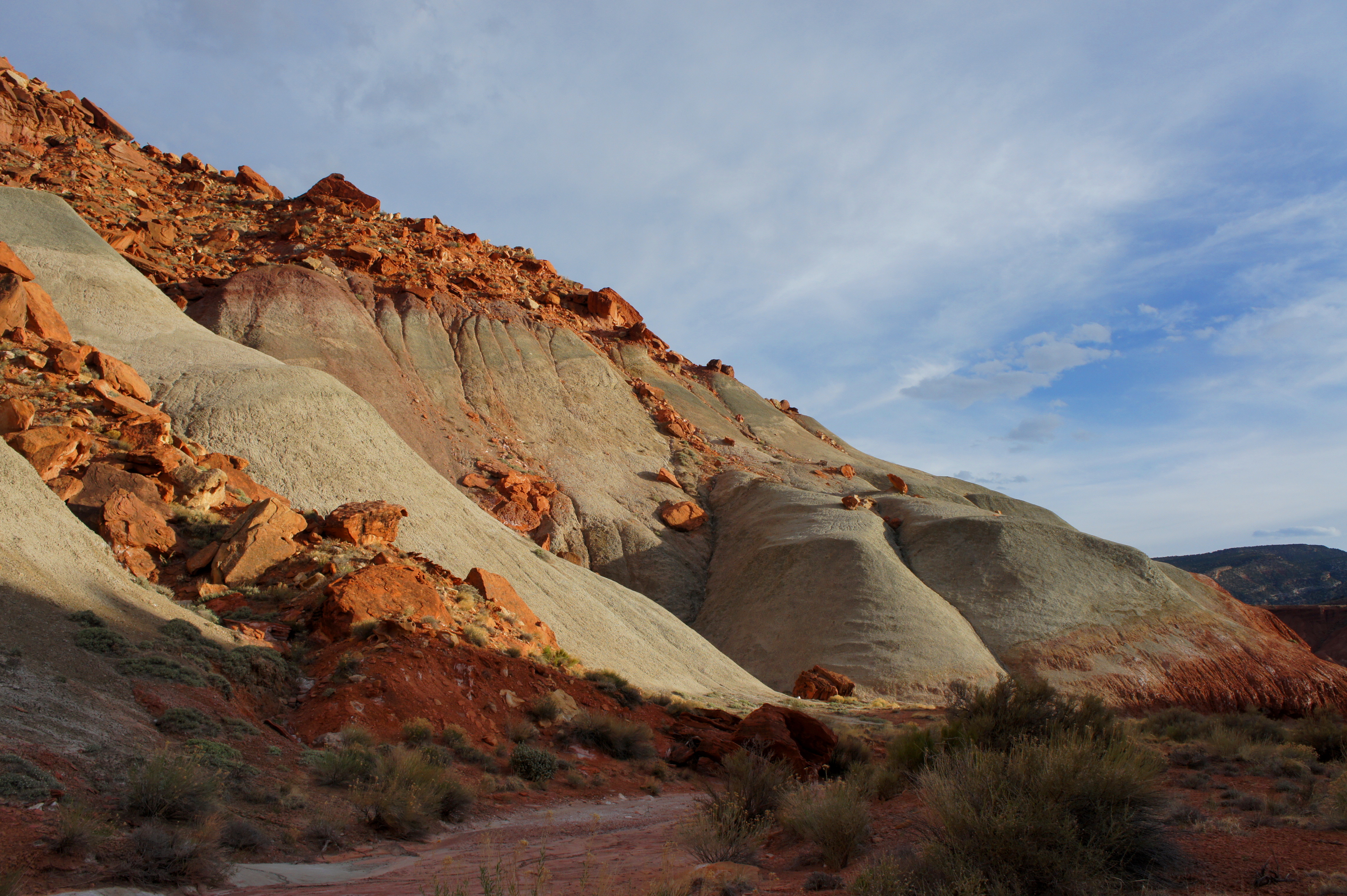
- The Castle Trail (Moderate; 2.4 mi. out-and-back, 1-2 hrs.)
The Castle Trail is actually no longer a trail, having been decommissioned (I believe) in the 1970s. For this reason, it is entirely absent from guidebooks and known perhaps only to rangers and local Capitol Reef enthusiasts. Nonetheless, the Castle Trail is signed and cairned in places. The hike begins across Highway 24 from the Visitor Center and winds through a dogleg canyon around The Castle into an eerie landscape of Martian-like badlands and pastel-colored hoodoos—a setting all-but-assured to be free of crowds.
See my post on April 21, 2015 for a map and full route description.

- Frying Pan Trail (Moderate to Strenuous; 2.9 mi. one-way, 1.5-2 hrs.)
The Frying Pan Trail serves as a connector route between the Cohab Canyon Trail and the Cassidy Arch Trail, but it is also far more than that. Aside from a dip into Frying Pan Canyon (a worthy side trip), the trail sits high atop the ledgey benches of the Kayenta formation, which affords excellent views in nearly all directions. Along the way, hikers will encounter enticing side canyons, dense pinyon-juniper concentrations, moqui marbles, and a series of peculiar-shaped spires (see if you can spot the duck and the buffalo).
See my post on January 24, 2015 for a map and full trail description.

- Cassidy Arch Trail (Moderate to Strenuous; 3.4 mi. out-and-back, 2-3 hrs.)
According to oral tradition, infamous outlaw Butch Cassidy and his “Wild Bunch” frequently passed through the Waterpocket Fold during their criminal heyday in the late 1880s. Whether Cassidy ever spotted the arch that now bears his name is an open question, but it is fun to imagine the crew of bandits weaving through Grand Wash and scaling the Kayenta ledges to the archway, just as hikers can do today. It is a 1.7-mile, moderately strenuous climb from the Grand Wash Trailhead to the top of the arch, complete with spectacular views and long stretches of classic slickrock.
See my post on January 22, 2015 for a full trail description.

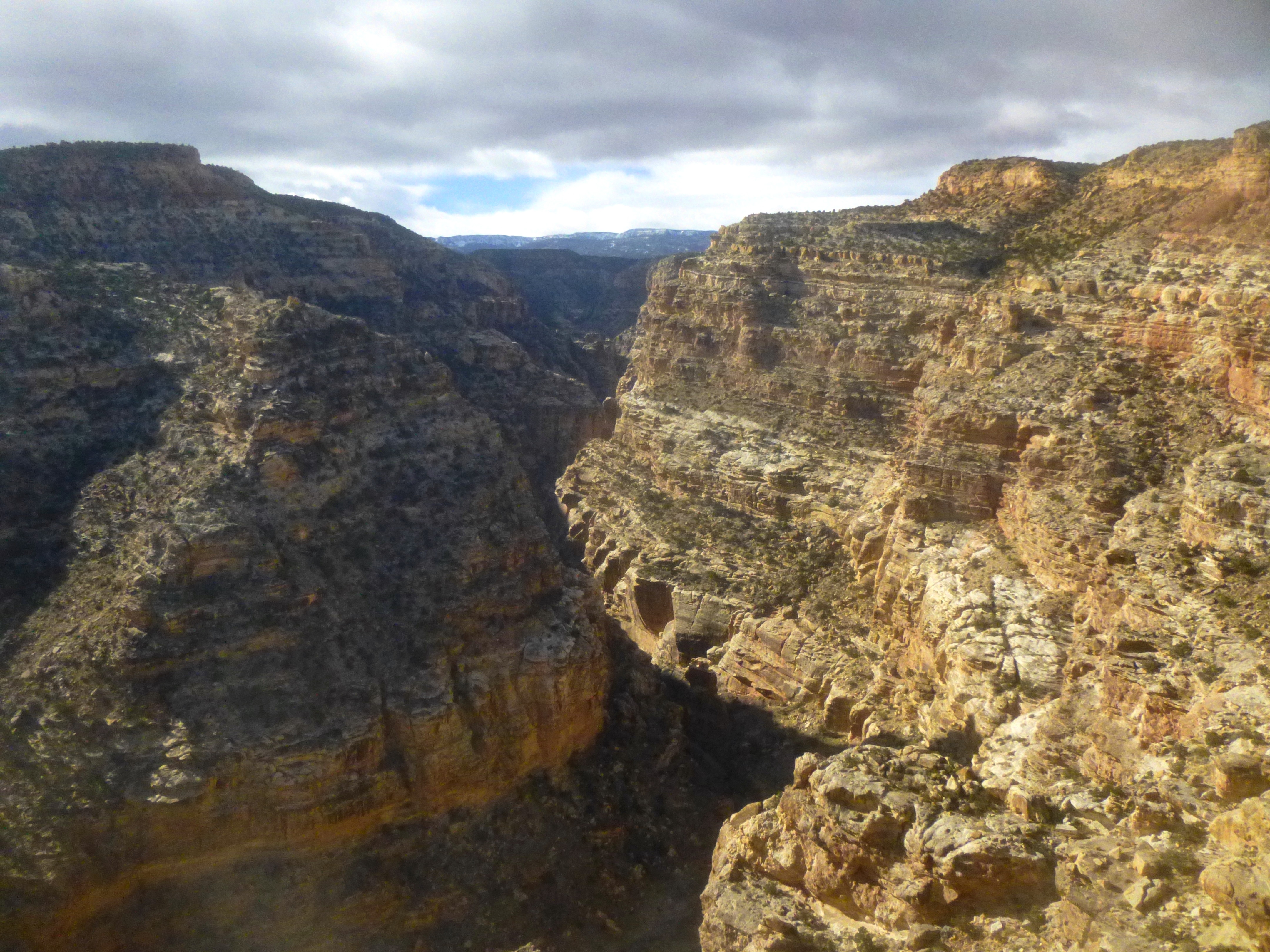
- Grand Wash Trail (Easy; 4.8 mi. out-and-back, 2 hrs.)
Grand Wash is one of the “must-sees” in the Fremont River District and a great hike for families and introductory hikers. The flat, easy trail simply follows the wash bottom as it weaves through three different rock layers, including a ½-mile stretch dubbed “The Narrows,” where passage through the towering Navajo sandstone thins to 16 feet. Access from either the Grand Wash Road or Highway 24.
See my post on December 15, 2014 for a map and full trail description.

- Sulphur Creek (Strenuous; 5.5 mi. one-way, 4-6 hrs.)
The Sulphur Creek route is a magical walk through an alluring canyon with colorful narrows, waterfalls, and enticing swimming holes. Hikers must work to reach these gems, however: this is a rugged route in which careful scrambling is required to bypass the three waterfalls, and wet boots are nearly impossible to avoid in a handful of spots. Most complete the 5.5-mile trek as a shuttle hike, beginning at the Chimney Rock Trailhead and hiking downstream to the Visitor Center.
See my post on April 8, 2015 for a full trail description.
- Fremont Gorge Overlook Trail (Moderate to Strenuous; 4.6 mi. out-and-back, 3-4 hrs.)
Surprisingly, the Fremont Gorge Overlook Trail is frequently overlooked; it is one of the least travelled of the area’s 15 maintained trails. Yet it certainly one of the most spectacular, featuring sweeping views of the Waterpocket Fold, the Fruita historic district, and the Fremont River Gorge. Much of the hike is spent climbing—first some 300 feet from the Scenic Drive, then another 600 feet to the overlook of Fremont Gorge—but the ascent is interrupted by a lengthy stroll across flattop Johnson Mesa, littered with mysterious black basalt boulders.
See my post on December 21, 2014 for a map and full trail description.

- Rim Overlook and Navajo Knobs Trail (Strenuous; 9.4 mi. out-and-back, 4-5 hrs.)
Navajo Knobs offers arguably the finest panoramic view in the Fremont River District accessible by trail, while the halfway point—Rim Overlook—is not too shabby, either. Both provide excellent vantage points of the Fruita area, Cohab Canyon, Waterpocket Fold, and Miners Mountain, while “the Knobs” throw in a peek to the north into Spring Canyon and the Cathedral Valley District beyond. The trail to the two overlooks is steep and persistent, and the final ascent to Navajo Knobs requires modest scrambling.
See my post on December 21, 2014 for a map and full trail description.

- Cohab Canyon Trail (Moderate; 1.7-2.9 mi. one-way, 1-2.5 hrs.)
There is arguably no more elaborately carved canyon in Capitol Reef than Cohab Canyon, where the walls of Wingate sandstone are speckled with honeycombed solution pockets and sliced dramatically into hundreds of minor slots. Beyond the Wingate are an impressive hoodoo and small archway in the Kayenta formation, as well as two short spur trails to overlooks high above Fruita and the Fremont River. The Cohab Canyon Trail is best completed as a shuttle hike, beginning at the Fruita Campground and ending at the Hickman Bridge Trailhead along Highway 24.
See my post on May 31, 2015 for a full trail description.
—
There you have it—a Spark Notes guide of sorts to Capitol Reef’s frontcountry hikes. Comments welcome!

I’m heading to Capitol Reef in October Andrew, and your posts have been part of my extensive research into the various trails, in all sections, of the park. I enjoy your descriptions, writing style, and obvious appreciation, of the area. Keep writing, it is being read.
Thanks John! Means a lot that fellow hikers are finding it useful. Capitol Reef is a spectacular – and underrated – park that is well-worth the research!
Great list of hikes, Andrew! We still a few hikes we didn’t get to even after 18 days there this year and a 10 day visit two years ago. Maybe next spring the rain won’t be quite as bad as this year. We really appreciate your posts with all the detail and photos. Thanks for helping us out several times with great directions.
We were interp rangers for 4 years and feel your pain. Do some basic research people! That said, your guides are much better than the park’s web pages.
Pingback: Top 10 Hikes in Capitol Reef National Park’s “Backcountry” | Live and Let Hike
Pingback: Introducing the Capitol Reef Trail Guide! | Live and Let Hike
Thank you! We are taking our young kids in a couple of weeks and are wanting to hit the least populated but most scenic hikes. Your info has been very helpful.
Glad to hear! Have a great trip!
Thank you! Planning my trip to Utah and found it very helpful. Check out my Moab blog 🙂
Yes! I’m so happy to find this page as the descriptions are clear and concise and definitely inspiring. We will be there in a few weeks with our children and your research is very much appreciated. Thank you.
Great, glad you like it! Have a great trip!
Thankful you have put time recounting your hikes. Very helpful for out of town travelers looking for hikes off the beaten path, but still nearby-ish!
Glad you liked it!
Pingback: Top 10 Hikes in 2017 | Live and Let Hike
I like this list. I have hiked half and will get to them all eventually. However, you left off a really good family hike up to Hickman Natural Bridge.
Thanks Gordon – I have mixed feelings about Hickman Bridge. It’s a nice and quick hike, but more crowded and not nearly as spectacular as some of the other hikes in the area.
Andrew,
Thanks for the detailed information. My wife and I are spending a couple of days in capital reef this July. What would you recommend as a couple of must do hikes?
Matt
Hi Matt – I would recommend a day doing a couple of these hikes – especially Cohab Canyon, maybe Grand Wash/Frying Pan, then spend a second day in the backcountry, which is even better: https://liveandlethike.com/2015/07/15/top-10-hikes-in-capitol-reef-national-parks-backcountry/
Andrew – love your summaries of Capital Reef hikes. This will be our third trip to Capital Reef in three years and have done Hickman Bridge as well as Grand Wash/Frying Pan/Cassidy Arch as well as driving the Burr Trail. We only have a day and a half in this area – trying to decide between a few possibilities. We thought we would do Cohab Canyon and then possibly Upper Muley Twist or Lower Spring Canyon. Would love to do Upper Muley but we are staying right in Torrey so with travel time – would make for a pretty long day. Would love your suggestions! We are fit hikers – often do 10-15 mile hikes & come to Utah to get outdoors and get our shoes dirty. I bring a camera along so we enjoy to challenge ourselves with our hikes but also to capture some beautiful vistas. Would love your suggestions! Bev & Rick
Hi Bev – glad you like the site! Can’t go wrong with Cohab Canyon. Alas, yes, Upper Muley is a drive, but well worth it – far from the crowds and doable in a long day if the roads are in good condition. Lower Spring is only worth it if you have two cars, as it is a one-way hike (with a chilly river crossing at the end!). Check out the trail descriptions for all these hikes elsewhere on the site!
How to choose? These all sound wonderful. We are staying a night in the Fruita campground, coming from Zion and Bryce and heading to Arches and Dead Horse Point. We will probably have time for one shortish hike when we arrive in the afternoon and a longish one the next morning (for that, we are thinking of Cohab/Frying Pan/Cassidy Arch shuttle.
Thanks for sharing. I’m from Australia and plan to be in the area in March. Your tips have added the my chaotic list of venues I’d like to see.
Pingback: Top 10 Hikes in 2018 | Live and Let Hike
An interesting take on the options available to visitors to the park. As ‘older’ non-US citizens, we did some homework before we came as part of a ‘Utah Loop’ vacation. I’d heard much about Capitol Reef and it certainly lived up to the expectations. I’d just have one minor quibble; for us, the Capitol Gorge Trail was much more satisfying a trek than the Grand Wash (though in September it was in the mid 90’s F for both!) but I wish I’d found this site before we went as I would have been ‘all over’ the Castle Trail as that sounds (and photographically) looks very interesting. I still came away with a wealth of images and an array of very fond memories. We just need to find the time to come back (when it’s cooler…). Keep up the great work – these places need people like you to build on experiences.
Great to hear; thanks for the feedback! In the end, you can’t go wrong with any of these trails. Capitol Reef is great 🙂
Headed there with my 3 teens and am so excited to read that we can skip the crowds here. Heading to Utah was starting to feel more and more like a Disney trip so it was great to read your posting and I’m excited again. I don’t want to miss the wonders of Zion and Arches but I’m guessing Capitol Reef might be the one on our “we have to come back here” trip.
Agreed that Utah’s parks are getting overcrowded – but fortunately Capitol Reef is still a relatively undiscovered gem!
thank you for input—I always love reading about which hikes other hikers recommend. We have been here less than 24 hours but we have managed to hike the Rim Overlook trail all the way up to Navajo Knobs, Grand Wash, Cassidy arch and Cohab Canyon. We have half a day left and we will hit Capitol Gorge up to the tanks and Golden Throne tomorrow . morning.
Pingback: Top 10 Hikes in 2019 | Live and Let Hike
Pingback: Return to Capitol Reef National Park | Live and Let Hike
Great assessment of recommended hikes. We did three of these in Oct 2020 – Castle, Grand Wash and Cohab and found your information reliable and accurate. Thank you so much! Weather was perfect for these.
Pingback: Top 10 Hikes in 2020 | Live and Let Hike
Pingback: Top 10 Hikes in 2021 | Live and Let Hike
We’re out-of-state folks headed to see the fabulous parks in Utah and will be visiting Capitol Reef soon. Unfortunately, we only only have a few days to stay in Capitol Reef on this trip, but this fantastic resource will help us make the most of the limited time we have. Thank you so much for the effort you put into creating and sharing this awesome guide (and your whole website, for that matter) with others!