Bear Gulch Cave – Rim Trail Loop (Pinnacles National Park, CA)

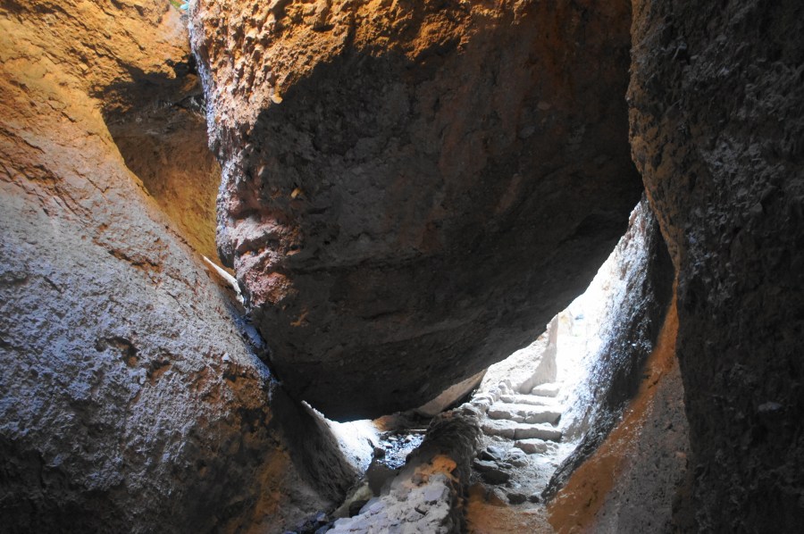
Sporting one of California’s finest talus caves and shoreline access to a picturesque, rock-hewn reservoir, the Bear Gulch Cave Trail is one of the most popular hikes in Pinnacles National Park. Here a jumble of boulders, so large and tightly-packed that it blankets the ground with darkness, forms subterranean passages home to a resident colony …

Continue reading Bear Gulch Cave – Rim Trail Loop (Pinnacles National Park, CA)

Top 10 Hikes in 2019

2019 has come and gone, and it was an excellent year for hiking. Over the course of the year, I added 43 posts to Live and Let Hike and notched nearly 150,000 site visits (81,000 visitors). As always, the travel was diverse, spanning hikes and scenic drives from 13 states (plus the District of Columbia), …

Continue reading Top 10 Hikes in 2019

Condor Gulch – High Peaks Trail Loop (Pinnacles National Park, CA)

Originally the work of volcanoes 23 million years ago, the rocks of today’s Pinnacles National Park were moved, upended, chiseled, and weathered by water, wind, and the infamous temper of the San Andreas Fault in central California. The result is a wild paradise of formations, boulders, spires, and talus caves, less than a two-hour’s drive …

Continue reading Condor Gulch – High Peaks Trail Loop (Pinnacles National Park, CA)

Mount Diablo via Eagle Peak and Mitchell Canyon (Mount Diablo State Park, CA)

At 3,849 feet, Mount Diablo is one of the highest and most prominent peaks in the San Francisco Bay Area and perhaps the most well-known mountain in the East Bay. Taking its name from a linguistic accident in the early 19th century, this “Devil’s Mountain” makes for a very long and imposing climb for modern …

Continue reading Mount Diablo via Eagle Peak and Mitchell Canyon (Mount Diablo State Park, CA)

North Dome Trail, inc. Indian Rock (Yosemite National Park, CA)

Most visitors seeking views of Yosemite Valley from above will drive out to the end of the Glacier Point Road for a fantastic, but crowded, vista. Those looking for a greater challenge with arguably greater payoff, however, should consider the all-day hike out to North Dome (7,542’), which has maybe the best vantage point of …

Continue reading North Dome Trail, inc. Indian Rock (Yosemite National Park, CA)

Ben Johnson-Bootjack Trail Loop (Muir Woods National Monument, CA)

The redwood groves of Muir Woods National Monument, while lovely, have a people problem. Within a half-mile radius of the park’s tiny visitor center, there are scores and scores of visitors. Yet the western stretches of the park—or better yet, the areas belonging to Mount Tamalpais State Park that surround Muir Woods—solitude and wildness are …

Continue reading Ben Johnson-Bootjack Trail Loop (Muir Woods National Monument, CA)

Coastal Trail to Tennessee Point (Golden Gate National Recreation Area, CA)

Named for the SS Tennessee, a commercial steamer that wrecked nearby in 1853, Tennessee Point is one of the best vantage points overlooking the Pacific Ocean in Golden Gate National Recreation Area’s Marin Headlands area. A relatively easy hike leads to the popular vista, following a section of the California Coastal Trail before branching off …

Continue reading Coastal Trail to Tennessee Point (Golden Gate National Recreation Area, CA)

Point Bonita Lighthouse Trail (Golden Gate National Recreation Area, CA)

Throughout much of San Francisco’s history, ships seeking to enter the Bay Area flirted with disaster: jagged rocks, shallow beds, dense fog, and nasty waves left hundreds of vessels in the 19th and 20th centuries capsized, torn apart, and buried at the ocean floor. As thousands of gold prospectors—from all over the world—flocked to San …

Continue reading Point Bonita Lighthouse Trail (Golden Gate National Recreation Area, CA)

Purisima Creek Redwoods Loop (Purisima Creek Redwoods Open Space Preserve, CA)

The San Francisco Bay Area in northern California is a fantastic launching point for redwood hunters, with accessible groves of these mesmerizing trees within an hour and a half both north and south of the Golden Gate. While the largest groves lie further north, the Santa Cruz Mountains between the Bay Area and Santa Cruz …

Continue reading Purisima Creek Redwoods Loop (Purisima Creek Redwoods Open Space Preserve, CA)

Coastal Trail – Lands End Section, including Mile Rock Beach (Golden Gate National Recreation Area, CA)

Coastal Trail - Lands End Section, Golden Gate National Recreation Area, December 2017 The windswept shoreline of Lands End forms the northwest tip of the San Francisco Peninsula and is easily accessible from northern California’s iconic cultural capital. For those looking for a brief urban escape, the Land’s End section of the Coastal Trail offers …

Continue reading Coastal Trail – Lands End Section, including Mile Rock Beach (Golden Gate National Recreation Area, CA)